Class 11 Humanities . History . Themes In World History . Writing and City Life
Chapter 1: WRITING AND CITY LIFE
Ch 1
History
Class 11 Humanities
Introduction & Mesopotamia and Its Geography
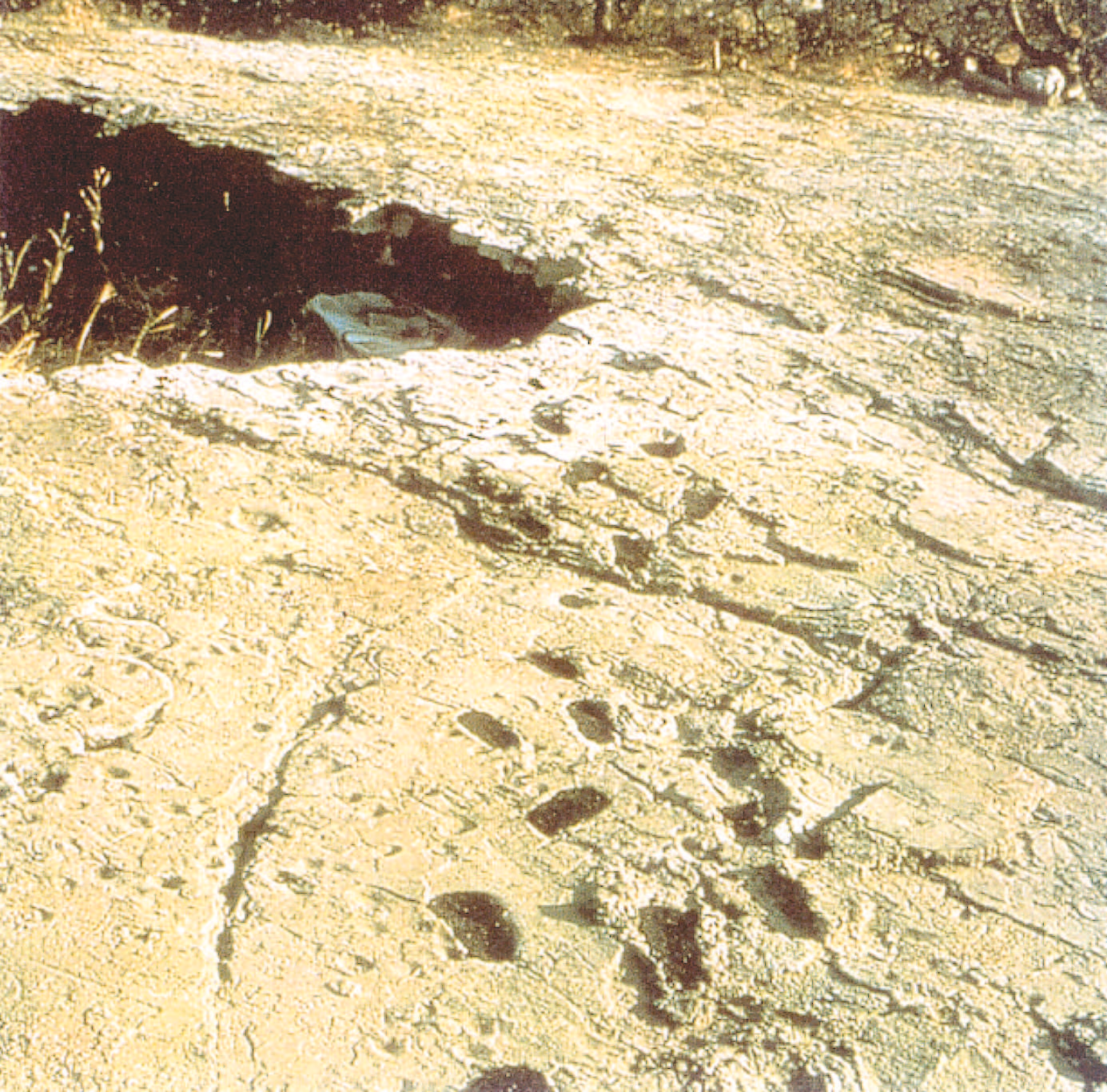
From Early Communities to Cities
Early societies — Communities whose lives and changes are reconstructed mainly through archaeological remains and other surviving evidence.
How archaeologists reconstruct early life
- Evidence: Bones and stone tools help investigate early humans; remains can also reveal shelters, food, and forms of expression.
- Developments: The use of fire and language were important changes in early human life.
- Early livelihoods: People gathered plant foods and hunted animals before farming became established.
- Mesopotamia: Archaeological remains and many written documents help reconstruct the lives of craftspeople, scribes, labourers, priests, rulers, and pastoral people.
Long-term changes before the first cities
- Growing knowledge of plants → people learned where and when useful plants grew.
- Cultivation and animal domestication → food production became more dependable.
- Settled farming → people stayed near fields and built more permanent homes.
- New technologies and exchange → pottery, improved tools, metals, and long-distance movement of goods developed.
- Growing settlements and trade → villages, towns, small states, and eventually cities emerged.
Changes linked to farming
- Crops: West Asia grew wheat, barley, peas, and pulses; East and Southeast Asia grew millet and rice; millet was also grown in Africa.
- Animals: Sheep, goats, cattle, pigs, and donkeys were domesticated; cattle and donkeys were later used to pull ploughs and carts.
- Materials: Cotton and flax plant fibres, and animal wool, were woven into cloth.
- Pottery and tools: Earthen pots stored and cooked food; mortars and pestles processed grain, while polished stone axes and hoes helped clear and cultivate land.
- Metals and exchange: Copper and tin ores were used; people also moved goods such as wood, stone, metals, shells, and obsidian between places.
Selected landmarks in the timeline
- 6 million–500,000 years agoAustralopithecus fossils are recorded in Africa; evidence of fire use is listed for Africa and China.
- 195,000 BPHomo sapiens fossils are recorded in Africa; fossils are also listed in West Asia at 100,000 BP.
- 30,000–10,000 BCCave and rock-shelter paintings are recorded in Africa and Europe.
- About 10,000 years agoThe gradual shift from nomadic life to settled agriculture began.
- 8000–7000 BCESheep and goats were domesticated and wheat and barley cultivated in West Asia.
- 7000–6000 BCEAgriculture began in the north-eastern plains of Iraq; early agricultural settlements are recorded in Baluchistan.
- 5000–4000 BCEThe timeline records copper use in West Asia and cotton cultivation in South Asia; cattle and donkeys were harnessed to ploughs and carts around 5,000 years ago.
- 3600 BCEThe wheel for transport is recorded in West Asia.
- 4000–3000 BCEThe timeline records the potter’s wheel, bronze, and writing in Mesopotamia, dated to 3200 BCE.
- 3000–2000 BCECities developed in Mesopotamia; the Harappan cities and their script are recorded in South Asia.
- After 2000 BCEBabylon became an important city and Mesopotamian writing and literature spread to parts of the eastern Mediterranean, Syria, and Turkey.
How to read historical timelines
- Processes and events: Gradual changes in ordinary people’s lives are harder to date precisely than events such as wars.
- Dates: A date may mark the beginning of a process or the time it became established.
- Changing evidence: Historians may revise dates as new evidence or methods of assessment become available.
- Geographical divisions: Timeline columns are convenient categories; historical developments often crossed these boundaries.
- Gaps and overlaps: Processes may overlap in time; blank spaces can mean that evidence is not yet known, not that nothing happened.
Mesopotamia and Its Historical Background
Mesopotamia — A region between the Euphrates and Tigris rivers, in present-day Iraq; its name comes from Greek words meaning “middle” and “river.”
Why Mesopotamia is significant
- Urban life: Some of the earliest cities emerged in Mesopotamia, especially in its southern region; cities developed around temples and became centres of long-distance trade.
- Achievements: The civilisation is known for city life, extensive literature, mathematics, astronomy, and writing.
- Regional influence: After 2000 BCE, Mesopotamian writing and literature helped kingdoms in surrounding regions communicate with one another and with Egypt.
- Sources: Archaeologists use buildings, statues, ornaments, graves, tools, seals, and thousands of written documents to study the region.
| Name or language | Period or change | Key point |
|---|---|---|
| Sumer and Akkad | Beginning of recorded history | Names used for the land, mainly its urbanised south. |
| Sumerian | Earliest known language of the land | Gradually replaced by Akkadian. |
| Akkadian | Around 2400 BCE onward | Arrived with Akkadian speakers and flourished until about Alexander’s time, with regional changes. |
| Babylonia | After 2000 BCE | Name used for the southern region as Babylon became important. |
| Aramaic | Entered from about 1400 BCE; widely spoken after 1000 BCE | Similar to Hebrew and still spoken in parts of Iraq. |
| Assyria | From about 1100 BCE | Name associated with the kingdom established by the Assyrians in the north. |
Archaeology and interpretations of Mesopotamian history
- 1840sArchaeological work in Mesopotamia began; excavations at sites such as Uruk and Mari continued for decades.
- 1873A British Museum expedition, funded by a British newspaper, searched for a tablet telling the Flood story mentioned in the Bible.
- By the 1960sScholars no longer treated Old Testament stories as literal accounts; they considered them possible expressions of memories about historical changes.
| Evidence | Interpretation | |
|---|---|---|
| Earlier approach | Biblical references to places such as “Shimar,” identified with Sumer, and the brick-built cities. | Some European travellers and scholars hoped archaeology would prove the literal truth of the Old Testament. |
| Later approach | Archaeological techniques and the study of many material and written sources became more developed. | From the 1960s, scholars focused more on reconstructing past changes and the lives of ordinary people. |
Flood stories
- Biblical account: Noah builds an ark and saves pairs of animals and birds from the Flood.
- Mesopotamian tradition: A similar Flood story features Ziusudra or Utnapishtim.
- Historical significance: Flood myths may preserve or express memories of important changes in people’s past.
Mesopotamia’s Geography and Resources
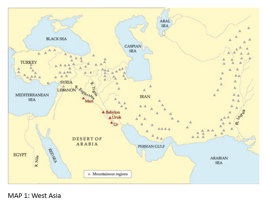
| Region | Environmental features | Livelihood or importance |
|---|---|---|
| North-east | Green plains rise towards wooded mountains; streams and rainfall are available. | Crops could grow; agriculture began here between 7000 and 6000 BCE. |
| North | Upland steppe with grasses and low shrubs after winter rains. | Sheep and goat herding was often more suitable than farming. |
| East | Tigris tributaries connect towards the mountains of Iran. | Routes of communication into the mountains. |
| South | Desert, crossed by the Euphrates and Tigris from northern mountains. | River silt and irrigation supported fertile fields, cities, and writing despite low rainfall. |
How southern Mesopotamia supported farming
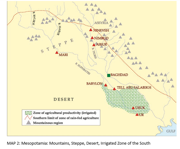
- Rivers rise in northern mountains → the Euphrates and Tigris carry fine silt.
- Floods or managed water → fertile silt is deposited and river water can be directed onto fields.
- Channels in the desert → small channels of the Euphrates could function as irrigation canals.
- Crops grow with controlled watering → wheat, barley, peas, and lentils could be cultivated despite insufficient rainfall.
Resources beyond agriculture
- Herding: Sheep and goats grazed on the steppe, north-eastern plains, and mountain slopes, producing meat, milk, and wool.
- Other food: Rivers provided fish, while date palms produced fruit in summer.
- Key point: Rural food and resources mattered, but they alone do not explain why cities grew.
The Significance of Urbanism
Urban economy — An economy in which activities beyond food production—such as trade, manufacturing, and services—support life in towns and cities.
Features of urban life
- Not just population: A city is not simply a place with many people; its economy includes specialised work outside food production.
- Interdependence: City people are not self-sufficient and rely on products and services from other city and village people.
- Specialisation: A seal carver could specialise in fine carving but depend on others for bronze tools and coloured stones.
- Division of labour: Different people performed different jobs, such as making tools, obtaining metals, supplying fuel, and carving seals.
- Organisation and authority: Trade, storage, food deliveries, and distribution needed coordination; some people gave commands that others obeyed.
- Written records: Records helped manage complex urban activities and supplies.
Interdependence in city production
- Materials and fuel arrive → metals, stones, wood, and charcoal must be obtained from different sources.
- Specialists make goods → toolmakers, traders, and craftspeople each perform particular tasks.
- Trade and storage are organised → supplies of materials and food must be coordinated and kept available.
- Authority and records support coordination → commands and written documents help manage complex urban activities.
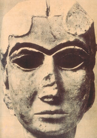
The Warka Head as evidence of urban specialisation
- Material: The woman’s head was carved from hard white marble, which had to be brought from a distance.
- Decoration: The eyes and eyebrows probably had inlays of blue lapis lazuli, white shell, and black bitumen.
- Skills and supply chains: Its production required access to imported materials and the work of specialists in obtaining, preparing, and carving them.
- Silt
- Fine mud carried by rivers and deposited on land, helping make soil fertile.
- Irrigation
- Supplying water to fields through channels or other managed means.
- Urbanism
- A way of life based on towns and cities, with specialised work and interdependent economic activities.
- Division of labour
- The organisation of work so different people specialise in different tasks.
Why could cities grow in the dry south of Mesopotamia?
What makes an economy urban, beyond having a large population?
How did the study of Mesopotamian history change over time?
Quick recap
- Farming and settlement: Cultivation and animal domestication encouraged settled life and helped transform communities over thousands of years.
- Cities: Mesopotamian cities developed around temples and depended on trade, specialised work, organised supplies, authority, and written records.
- Geography: Rivers, silt, irrigation, steppe herding, fish, and date palms supported life in Mesopotamia’s different environments.
- History and evidence: Archaeological remains and written sources reveal Mesopotamian life; interpretations changed as evidence and research methods developed.
- Urbanism: Specialisation and interdependence—not population size alone—are central features of city life.
Movement of Goods Into Cities
Trade and Transport
Mesopotamia’s resources and trade
- Resource shortage: Southern Mesopotamia had abundant food but little stone or metal; its date-palm and poplar wood was unsuitable for carts, wheels and boats.
- Exports: Mesopotamians could exchange textiles and agricultural produce for materials they lacked.
- Imports: Wood, copper, tin, silver, gold, shell and stones came from Turkey, Iran and across the Gulf, regions with more minerals but less agricultural land.
- Organisation: Regular exchange required social organisation to equip expeditions and manage trade.
| Region | Resources / role |
|---|---|
| Southern Mesopotamia | Agricultural produce and textiles; needed minerals, stone and suitable timber. |
| Turkey, Iran and regions across the Gulf | Sources of wood, metals, shell and stones; generally less scope for agriculture. |
| Point | Water transport | Land transport |
|---|---|---|
| Cost and effort | Generally the cheapest mode; boats could use river currents and/or wind. | Pack animals and bullock carts required time and animal feed. |
| Mesopotamian routes | Rivers, canals and natural channels linked large and small settlements. | Goods could also be carried by animals and carts. |
| Importance | Efficient movement of grain and charcoal helped make city economies viable. | Excessive time or feed costs could undermine a city’s economy. |
The Development of Writing
Writing — A form of verbal communication that represents spoken sounds as visible signs.
Why writing began
- First records: The earliest Mesopotamian tablets had picture-like signs and numbers, recording goods such as oxen, fish and bread.
- Purpose: Around 5,000 lists recorded goods brought into or distributed from the temples of Uruk.
- Urban need: City transactions involved many people, varied goods and different times, creating a need for reliable records.
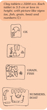
Clay tablets and record-keeping
- Writing surface: Scribes shaped and smoothed moist clay, then pressed signs into it with the cut end of a reed.
- Cuneiform: The reed produced wedge-shaped signs; sun-dried tablets hardened and could last like pottery.
- Separate records: Once dry, a tablet could not be written on again, so each transaction needed its own tablet.
- Historical evidence: Large numbers of tablets survive; these records make Mesopotamia better documented than contemporary India.
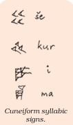
Development and use of Mesopotamian writing
- c. 3200 BCEEarly tablets used picture-like signs and numbers to record goods.
- c. 2600 BCEWriting had developed into cuneiform, used to write Sumerian.
- After 2400 BCEAkkadian gradually replaced Sumerian as the spoken language.
- Until the first century CECuneiform continued to be used for Akkadian for more than 2,000 years.
Changing uses of writing
- Beyond accounts: Writing came to serve dictionaries, legal records of land transfers, royal achievements and announcements of changes to customary laws.
- Language change: Sumerian was the earliest known Mesopotamian language; Akkadian gradually replaced it after 2400 BCE.
- Long use: Cuneiform continued to be used for Akkadian until the first century CE.
The System of Writing
Cuneiform signs
- Syllabic system: A cuneiform sign represented a syllable, not a single consonant or vowel.
- Complexity: Scribes had to learn hundreds of signs and write quickly before the wet clay dried.
- Achievement: Writing converted the sounds of a particular language into a visual system and required considerable skill.
Literacy
Who could read and write?
- Limited literacy: Few Mesopotamians could read and write because the script had hundreds of signs, many of them complex.
- Spoken communication: Letters were often read aloud to rulers; their wording reflected spoken forms of address.
- Oral learning: Myths and other works were also remembered and passed on by elders, scholars and parents, and could reach people such as herdsmen.
- Status: A king who could read might boast of this ability in an inscription.
The Uses of Writing
Enmerkar, trade and writing
- Uruk: Mesopotamian tradition called it “The City”; Enmerkar was remembered as one of its earliest rulers and as an organiser of Sumer’s first trade.
- Trade mission: Enmerkar sought lapis lazuli and precious metals for a temple and sent a messenger to the distant land of Aratta.
- Need for writing: The messenger made repeated journeys carrying the king’s messages. When he became confused and mixed them up, Enmerkar wrote the words on a clay tablet.
- Meaning of the story: The epic links kingship with organising trade and writing, which stored information and carried messages over distance.
How trade and urban life encouraged writing
- City life involved many people and different goods.
- Trade and distribution took place at different times.
- These exchanges needed dependable records and messages.
- Writing helped organise transactions and became an important feature of urban culture.
- Cuneiform
- Wedge-shaped writing signs impressed on clay tablets.
- Sumerian
- The earliest known language of Mesopotamia.
- Akkadian
- A language that gradually replaced Sumerian after 2400 BCE.
- Scribe
- A trained person who wrote records on clay tablets.
Do not treat the Enmerkar epic as a literal historical account; it reveals Mesopotamian ideas about the links between kingship, trade and writing.
Why did writing develop in Mesopotamian cities?
What made cuneiform difficult to learn, and why was it a major achievement?
Quick recap
- Southern Mesopotamia traded food and textiles for scarce stone, metals and suitable timber.
- Rivers, canals and natural channels were economical routes for moving goods into and between settlements.
- The earliest tablets recorded goods; urban transactions created a need for written records.
- Cuneiform used hundreds of wedge-shaped signs, each representing a syllable.
- Writing expanded from accounts to legal records, dictionaries and royal inscriptions; literacy remained limited.
- The Enmerkar epic connects kingship, trade and writing, but should not be read as literal history.
Urbanisation in Southern Mesopotamia: Temples and Kings
The Growth of Temples and Cities
Early urban settlements
- Beginnings: Settlements in southern Mesopotamia developed from about 5000 BCE; some grew into cities.
- City types: Cities grew around temples, as trade centres, or as imperial cities. This lecture focuses on temple towns and trade centres.
- Temples: Villagers repeatedly built temples at selected sites. The earliest known was a small shrine made of unbaked bricks.
- Design: Temples grew larger, with brick rooms around open courtyards. Their outer walls had regular in-and-out projections, unlike ordinary buildings.
- Gods: A temple was understood as the residence of a god, such as the Moon God of Ur or Inanna, goddess of love and war.
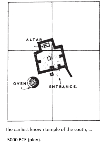
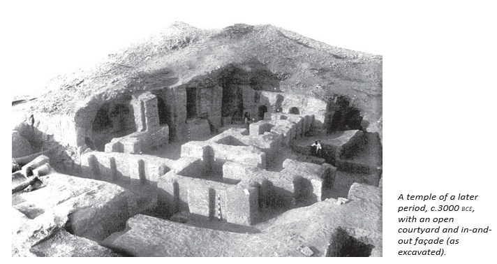
The temple as an urban institution
- Offerings: People brought grain, curd and fish to the god; thick layers of fish bones were found on some temple floors.
- Ownership: The god was considered the theoretical owner of the community’s fields, fisheries and herds.
- Production: Temples organised activities beyond the household, including oil pressing, grain grinding, spinning and wool weaving.
- Administration: Temples employed merchants and kept written records of goods distributed, including grain, plough animals, bread, beer and fish.
- Importance: As production and record-keeping expanded, the temple became the principal urban institution.
Conflict, Kingship and the Rise of Uruk
Why conflict over land and water occurred
- Euphrates channels sometimes flooded fields or changed course.
- Upstream communities could divert water or fail to clear silt from canals.
- Downstream villages could lose water and crops.
- Disputes over land and water became recurrent in the countryside.
From war leaders to kings
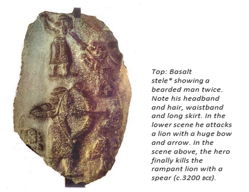
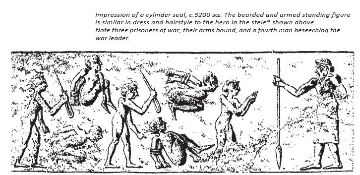
- Warfare gave successful chiefs loot and captives, increasing their influence.
- Chiefs offered valuable booty to gods and improved community temples.
- Leaders organised the acquisition of materials and accounted for temple wealth.
- Efficient management and temple patronage strengthened leaders’ authority and status as kings.
Uruk: population, labour and technology
- Population shift: Uruk’s growth drew people from nearby villages; surveys show dozens of villages were deserted as the city expanded.
- Defence: Uruk developed a defensive wall early. Leaders encouraged people to settle close together for safety and to assemble an army quickly.
- Compulsory work: Captives and local people worked for temples or rulers. Labour, rather than agricultural tax, was compulsory; workers received rations.
- Ration records: Hundreds of lists record people’s names and allocations of grain, cloth or oil.
- Construction scale: One temple was estimated to require 1,500 workers, labouring 10 hours daily for five years.
- Building and crafts: Bronze tools, brick columns and coloured clay-cone mosaics were used; fine sculpture was made from imported stone.
- Potter’s wheel: It enabled workshops to produce many similar pots, supporting an urban economy.
Key dates and periods
- From 5000 BCESettlements began developing in southern Mesopotamia.
- c. 4200 BCE–c. 400 CEUruk was continuously occupied.
- c. 3200 BCEA cylinder-seal impression depicts prisoners before a leader.
- Around 3000 BCEUruk reached about 250 hectares; technical advances included bronze tools and brick columns.
- By c. 2800 BCEUruk had expanded to about 400 hectares.
- 2500 BCEAbu Salabikh covered about 10 hectares and had fewer than 10,000 residents.
- Around 2000 BCEMari flourished as a royal capital; Ur’s residential area is also shown for this period.
- 1810–1760 BCEZimrilim ruled Mari.
- Until the end of the first millennium BCEMesopotamians used cylindrical stone seals.
The Seal: An Urban Artefact
How seals worked and why they mattered
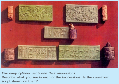
- Form: Mesopotamian seals were pierced cylinders of stone fitted onto a stick; rolling them over wet clay made a continuous image.
- Carving and inscriptions: Skilled craftsmen carved the seals. Some named the owner, their god or their official position.
- Security: A seal could mark the clay securing a package’s knot or a pot’s opening, helping protect its contents.
- Authentication: Rolled onto a clay-tablet letter, the seal served as a mark of authenticity.
- Urban role: A seal identified its owner’s place in public life. In contrast, early Indian stone seals were stamped.
Life in the City
Social hierarchy and family life
- Ruling elite: A small section of society held a large share of wealth. Royal graves at Ur contained jewellery, gold vessels, musical instruments inlaid with shell and lapis lazuli, and gold daggers.
- Family: Legal texts show that the nuclear family—man, wife and children—was the norm, though a married son might live with his parents. The father headed the family.
- Marriage: Marriage required the couple’s willingness and the bride’s parents’ consent. The groom’s family gave a gift to the bride’s family; both sides exchanged gifts at the wedding.
- Wedding customs: The families ate together and made temple offerings. When the bride left with her mother-in-law, her father gave her inheritance share.
- Inheritance: Sons inherited their father’s house, herds and fields.
Houses and streets at Ur
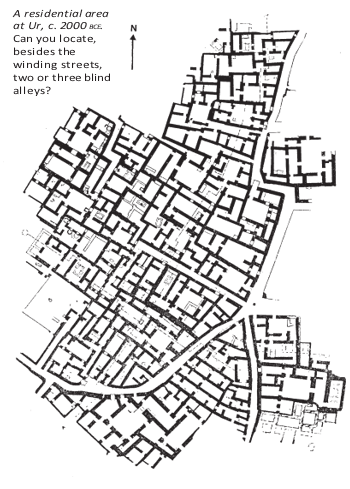
- Street pattern: Narrow, winding streets and irregular house plots show that Ur lacked systematic town planning; wheeled carts could not reach many houses.
- Transport: Donkeys carried sacks of grain and firewood to houses.
- Drainage: Unlike Mohenjo-daro, Ur had no street drains. Courtyard drains and clay pipes channelled rainwater into covered sumps.
- House structure: Roofs probably sloped inward so rainwater ran into courtyard drains. Doorways opening onto courtyards provided light and privacy.
- Rising street levels: Household refuse was swept into streets, raising their level; house thresholds had to be raised to keep rainwater and mud out.
- Burials: Ur had a cemetery for royalty and commoners, while some people were buried beneath house floors.
- Omen beliefs: Tablets linked a raised threshold with wealth and a door not facing another house with good luck; an outward-opening main door was considered unlucky for the wife.
Sump — A covered basin in the ground into which water and sewage flow.
Mari: A Trading Town in a Pastoral Zone
Agriculture, herding and cultural exchange
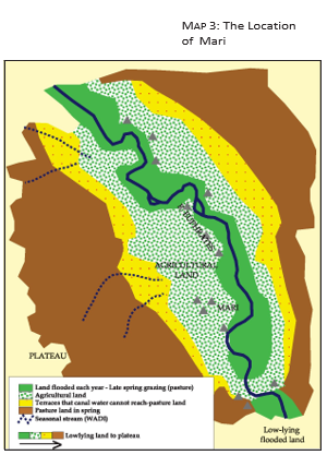
- Location: Mari stood upstream on the Euphrates, beyond the highly productive southern plain, where farming and animal herding existed side by side.
- Pastoral economy: Much of Mari’s territory was pasture for sheep and goats; some communities combined farming and herding.
- Exchange: Herders traded young animals, cheese, leather and meat for grain and metal tools. Manure from penned flocks benefited farmers.
- Sources of conflict: Flocks could damage crops by crossing fields; herders could raid villages, while settled communities could restrict access to river and canal water.
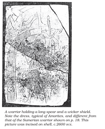
- Migration and settlement: Western desert groups entered the agricultural heartland as herders, harvest workers or soldiers; some prospered, settled and established dynasties.
- Peoples and rulers: Akkadians, Amorites, Assyrians and Aramaeans came from pastoral societies. Mari’s kings were Amorites, who also built a temple to Dagan, god of the steppe.
- Cultural openness: Mari’s rulers respected Mesopotamian gods while retaining links to their own traditions; interaction among peoples contributed to cultural vitality.
- Royal surveillance: Officials monitored tribal herder camps. Letters report night-time fire signals that could indicate a planned raid or attack.
Mari’s prosperity through trade
- Mari’s position on the Euphrates connected southern cities with mineral-rich uplands in Turkey, Syria and Lebanon.
- Boats carried wood, copper, tin, oil, wine and other goods along the river.
- Officials inspected cargo and charged about one-tenth of its value before boats continued downstream.
- A boat could carry 300 wine jars; barley travelled in special grain boats.
- Copper from Alashiya (Cyprus) and tin supported bronze production, making Mari exceptionally prosperous despite limited military strength.
Excavating Mesopotamian Towns
Archaeological methods and discoveries at Abu Salabikh
- Modern approach: Excavators now record evidence more carefully and usually avoid digging huge areas; limited funding also restricts the size of teams.
- Surface scraping: Removing a thin layer of soil exposed differences in colour, texture and lines that revealed walls, pits and other features.
- Recovery: Archaeologists excavated some houses and sieved large quantities of soil to find plant and animal remains.
- Food and fuel: Charred fish bones in streets and seeds and fibres left by burned dung cakes revealed diet and fuel use.
- Animals: Teeth of very young pigs found in streets suggest pigs roamed freely. Pig bones in one house burial may have been food for the dead in the afterlife.
- Room use: Rooms with many plant and fibre remains were identified as kitchens; living rooms had fewer traces.
- Roofing: Microscopic study of floors helped distinguish roofed rooms from open courtyards.
| Evidence | Interpretation | |
|---|---|---|
| Fish remains | Large quantities of charred fish bones in streets | Fish was eaten, and household refuse was swept into streets. |
| Seeds and fibres | Remains left after dung cakes were burned | These traces helped identify kitchens. |
| Young pig teeth | Teeth of very young pigs on streets | Pigs probably roamed freely through the town. |
| Floor traces | Microscopic differences on room floors | Archaeologists inferred which rooms were roofed and which were open to the sky. |
The Palace at Mari under Zimrilim
The palace as a royal and administrative centre
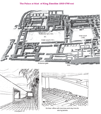
- Zimrilim: He ruled Mari from 1810 to 1760 BCE.
- Functions: The palace housed the royal family, ran administration and supported production, especially of precious metal ornaments.
- Scale: It had 260 rooms and covered 2.4 hectares; there was a single entrance on the north.
- Audience and ceremony: The king received foreign dignitaries and subjects in room 132, decorated with wall paintings.
- Daily life: Food lists record flour, bread, meat, fish, fruit, beer and wine supplied for the king’s table.
- Courtyards: Large open courtyards, including courtyard 131, were paved; the king may have dined with many people in or near courtyard 106.
- Nuclear family
- A man, his wife and their children.
- Cylinder seal
- A carved stone cylinder rolled on clay to create an impression.
- Pastoralist
- A person whose livelihood depends mainly on herding animals.
- Alashiya
- The ancient name for Cyprus, a source of copper traded with Mari.
- Sump
- A covered ground basin that receives water and sewage.
How did temples become the main urban institution in southern Mesopotamia?
Why was Mari prosperous even though it was not militarily strong?
Quick recap
- Temples combined worship, resource ownership, production, employment and record-keeping.
- Water and land disputes encouraged warfare; victorious leaders strengthened their authority through temple patronage and administration.
- Uruk’s expansion involved population shifts, compulsory labour, ration systems and new craft technologies.
- Cylinder seals secured goods, authenticated documents and signalled a person’s public role.
- Ur’s streets, houses, drains, family customs and burials reveal the everyday life and social divisions of a city.
- Mari prospered through trade and interaction between farming communities, herders and incoming pastoral peoples.
- Archaeologists use traces such as bones, seeds, fibres and floor marks to infer ancient diet, activities and buildings.
Cities in Mesopotamian Culture
City Life and the Epic of Gilgamesh
- City pride: Mesopotamians valued cities as places where people from many communities and cultures lived together.
- Gilgamesh Epic: After failing to find immortality, Gilgamesh returned to Uruk and took comfort in admiring its walls and foundations.
Writing, Mathematics and Timekeeping
Transmission of Mesopotamian Timekeeping
- Mesopotamian time divisions
- Adopted by the successors of Alexander
- Passed into the Roman world
- Passed to the world of Islam and then medieval Europe
Schools and the Preservation of Knowledge
- Schools: Students read and copied earlier tablets, preserving written knowledge across generations.
- Learning: Some students became intellectuals who built on earlier scholarship, not merely record keepers for the administration.
Assurbanipal’s Library at Nineveh
- Assyrian scholarship: Assyrian kings valued Babylonia as the centre of high culture and collected its literary and scholarly traditions.
- Preservation: Scribes copied and catalogued tablets on history, epics, omens, astrology, hymns and poetry.
Babylon and Nabonidus as a Preserver of the Past
Mesopotamian Chronology
- c. 7000–6000 BCEAgriculture began in the northern Mesopotamian plains.
- c. 5000 BCEThe earliest temples were built in southern Mesopotamia.
- c. 3200 BCEThe first writing appeared in Mesopotamia.
- c. 3000 BCEUruk developed into a huge city, with increasing use of bronze tools.
- c. 2700–2500 BCEEarly kings ruled, possibly including the legendary Gilgamesh.
- c. 2600 BCECuneiform script developed.
- c. 2400 BCEAkkadian replaced Sumerian as a spoken language.
- 2370 BCESargon ruled as king of Akkad.
- c. 2000 BCECuneiform spread to Syria, Turkey and Egypt; Mari and Babylon became important urban centres.
- c. 1800 BCEMathematical texts were composed, and Sumerian ceased to be spoken.
- c. 1100 BCEThe Assyrian kingdom was established.
- c. 1000 BCEIron came into use.
- 720–610 BCEThe Assyrian empire reached its height.
- 668–627 BCEAssurbanipal ruled.
- 625 BCENabopolassar freed Babylonia from Assyrian domination.
- 539 BCEThe Achaemenids conquered Babylon.
- 331 BCEAlexander conquered Babylon.
- c. 1st century CEAkkadian and cuneiform remained in use.
- 1850sCuneiform was deciphered.
- Cuneiform
- The wedge-shaped writing system used in Mesopotamia.
- Ziggurat
- A stepped tower forming part of a Mesopotamian city’s religious centre.
- Stele
- An upright stone slab bearing an inscription or carved image.
- Tribute
- Goods or resources extracted by a ruling power from subject peoples.
How did writing and schools support Mesopotamian scholarship?
What were the main features of Assurbanipal’s library?
How did Nabonidus use evidence from the past?
Quick recap
- Mesopotamians valued diverse city life, and the Gilgamesh Epic ends by celebrating Uruk and its wall.
- Mesopotamian scholars developed mathematics, astronomy and time divisions preserved through written records.
- Schools copied earlier tablets and kept Sumerian learning alive after it ceased to be spoken.
- Assurbanipal’s Nineveh library collected, checked, catalogued and preserved thousands of tablets.
- Nabonidus used ancient images and inscriptions to restore religious customs and honour earlier rulers.
- Babylon grew into a vast centre of power, trade, monumental building and scholarship.