SOLUTIONS

2022 BOARD EXAM

CBSE Class 12 Humanities Geography Board Paper 2022 — Set 1 Solutions

2022

Geography

Class 12 Humanities

CBSE EXAMINATION PAPER-2022

GEOGRAPHY

(Solved)

Time allowed : 3 hours

Maximum Marks : 37

General Instructions :

Read the following instructions carefully and follow them :

  1. This question paper contains 13 questions. All questions are compulsory.
  2. This question paper is divided into 3 sections.
  3. Section A – questions number 1 to 2 are case based questions
  4. Section B – questions number 3 to 9 are short answer
  5. Section C – questions number 10 to 13 are long answer
  6. There is no overall choice given in the question paper. However, an internal choice has been provided in few questions.
  7. Use of calculator is NOT allowed.

Section A

Question 1.

Read the following source and answer the questions that follow :

The concept of development is dynamic and has evolved during the second half of twentieth century. In the post World War II era, the concept of development was synonymous to economic growth which is measured in terms of temporal increase in Gross National Product (GNP) and per capita income/per capita consumption. But, even the countries having high economic growth, experienced speedy rise in poverty because of its unequal distribution. So, in 1970s, the phrases such as redistribution with growth and growth and equity were incorporated in the definition of development. While dealing with the questions related to redistribution and equity, it was realised that the concept of development cannot be restricted to the economic sphere alone. It also includes the issues such as improving the well-being and living standard of people, availing of the health, education and equality of opportunity and ensuring political and civil rights. By 1980s, development emerged as a concept encapsulating wide-spread improvement in social as well as material well-being of all in a society.

(1) Explain the meaning of 'Multidimensional concept of development'.

[1 Mark]
Answer: The 'Multidimensional concept of development' refers to an understanding of development that goes beyond mere economic growth measured by metrics like Gross National Product (GNP) and per capita income. It encompasses a variety of factors that contribute to the overall well-being of individuals and society. This includes improving the living standards, access to health care and education, ensuring equality of opportunity, and protecting political and civil rights. In the 1970s, it became evident that simple economic indicators did not adequately reflect the situation of many countries, where even economic growth was accompanied by rising poverty due to inequality in wealth distribution. Consequently, development began to be seen as a positive transformation that is holistic and integrates social, economic, and environmental considerations. By the 1980s, development had evolved into a comprehensive concept aimed at improving the social and material well-being of all members of society, highlighting the interconnectedness of economic, social, and environmental factors in the pursuit of progress.
Key Points: Economic growth alone is inadequate; focus on inequality; improvement of well-being; access to health and education; political and civil rights; holistic transformation; encapsulation of social and material well-being.

(2) Define the term 'sustainable development'.

[1 Mark]
Answer: Sustainable development is a holistic concept that emphasizes the need for positive, irreversible transformation in the economy, society, and environment, ensuring that current development meets the needs of the present without compromising the ability of future generations to meet their own needs. This concept emerged in response to the growing awareness of environmental issues and the realization that economic growth alone cannot ensure the well-being of society if it leads to environmental degradation and social inequalities. Sustainable development aims to balance economic growth, social equity, and environmental protection, advocating for a development process that enhances the quality of life for all, promotes health and education, and guarantees civil rights.
Key Points: holistic concept-economic growth-social equality-environmental protection-quality of life-education-health-civil rights

(3) Explain the difference between 'growth' and 'development'.

[1 Mark]
Answer: The concepts of 'growth' and 'development' often lead to confusion, yet they hold distinct meanings in the context of economics and societal well-being. 'Growth' refers to a quantitative increase in a country's economic output, typically measured by metrics such as Gross National Product (GNP) or per capita income. It is a value-neutral term; while it indicates an increase in economic activity, it does not provide insight into the distribution of wealth or the overall well-being of the population. For instance, a country may experience significant economic growth, yet a significant portion of its population could still live in poverty due to unequal distribution of resources.

On the other hand, 'development' entails a qualitative transformation in a society that emphasizes not just economic indicators but also the improvement of living standards, access to education and healthcare, and the promotion of equity and rights among its citizens. The shift in understanding towards development in the 1970s highlighted the importance of redistribution and equity alongside growth, emphasizing that sustainable progress must address both economic and social dimensions. Overall, while growth can occur without development, true development is contingent upon equitable growth that benefits all sections of society, thereby indicating that the two concepts, although related, are not synonymous.
Key Points: Growth is quantitative, value-neutral; Development is qualitative, value-positive; Growth does not guarantee equitable distribution; Development includes social well-being; Economic growth can coexist with poverty.
Question 2.

On the given political outline map of India, locate and label any five from the following ‘geographical features’ with appropriate symbols :
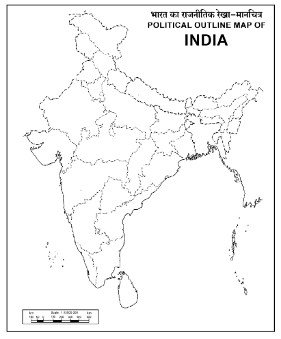
Diagram 1 – CBSE Class 12 Humanities Geography 2022 Set 1 Solutions

(1)

Ratnagiri-iron-ore mines.

[1 Mark]
Answer: To locate the Ratnagiri iron ore mines on the political outline map of India, first identify the Ratnagiri district located in the state of Maharashtra on the western coast. The iron ore mines can be marked approximately in the eastern part of Ratnagiri district. Use a symbol such as a small blue circle with 'Fe' inside to represent the iron ore mines, as iron is denoted by 'Fe' in chemistry. This will clearly indicate the presence of iron ore mines in the area of Ratnagiri.
Key Points: Locate Ratnagiri in Maharashtra-Identify the eastern part of Ratnagiri district-Mark with a blue circle symbol for iron ore-Label with 'Fe' for clarity

(2)

Bauxite mines located in Odisha.

[1 Mark]
Answer: Bauxite mines in Odisha are prominently located in the districts of Kalahandi, Sambalpur, Bolangir, and Koraput. When marking these locations on the map, use a triangle symbol to represent the bauxite mines. Kalahandi and Sambalpur are the largest producers, indicating that the area is rich in this mineral resource. Additionally, these districts are part of the larger mineral-rich geography of Odisha, which plays a crucial role in India's mining sector.
Key Points: Odisha - largest bauxite producer-Kalahandi, Sambalpur, Bolangir, Koraput- triangle symbol for mines

(3)

An oil refinery in Uttar Pradesh.

[1 Mark]
Answer: To locate and label an oil refinery in Uttar Pradesh on the political outline map of India, begin by identifying the state of Uttar Pradesh on the map. Then, pinpoint a specific oil refinery within the state. One notable oil refinery in Uttar Pradesh is the Mathura Refinery, located near the city of Mathura. Once you have located the refinery, use an appropriate symbol, such as a drop of oil, to label it clearly on the map. This refinery is significant as it contributes to the energy resources of India and is part of the larger network of oil supply in the region.
Key Points: Identify Uttar Pradesh on the map - Locate Mathura Refinery - Use a drop of oil symbol for labeling - Mention its significance in energy resources

(4)

Hazribagh copper mines.

[1 Mark]
Answer: The Hazribagh copper mines are located in Jharkhand, India. On the map, they can be represented with a suitable symbol for copper mines, usually a small mine icon or a circular symbol filled with orange or brown color. This area is part of the Himalayan mineral belt where various metallic minerals, including copper, are mined.
Key Points: Located in Jharkhand-copper mines-mining icon-symbol representation

(5)

The eastern-most station on the East-West corridor.

[1 Mark]
Answer: The eastern-most station on the East-West corridor is located at Silchar in Assam. To mark this on the political outline map of India, you would label the location of Silchar using a specific symbol, such as a star or a dot, indicating its significance as a key point on the East-West corridor. This corridor facilitates connectivity across the country, making Silchar an important geographical reference point in the northeastern region of India.
Key Points: Identify Silchar as the eastern-most station - Use appropriate symbols for labeling - Highlight its importance in the East-West corridor

(6)

The Southern-most metropolitan city connected by Golden Quadrilateral.

[1 Mark]
Answer: The southern-most metropolitan city connected by the Golden Quadrilateral is Chennai. Located in the southeastern part of India, Chennai serves as a major economic and cultural hub. It is one of the four metropolitan cities linked by the Golden Quadrilateral project, which aims to enhance connectivity across India by connecting Delhi, Mumbai, Chennai, and Kolkata through a network of highways. The marked location on the map can be symbolized with a dot or triangle represented appropriately as a metropolitan city.
Key Points: Chennai-Golden Quadrilateral-Connecting metro cities

Section B

Question 3.

How has ‘tourism’ become the world's single largest tertiary activity in terms of total revenues ? Explain with examples.

[3 Marks]
Answer: Tourism is travel undertaken for recreation and has become the world's single largest tertiary activity because it generates a large number of jobs and revenue. It accounts for 250 million registered jobs globally and contributes about 40 percent of the total GDP. Tourism creates employment in services such as accommodation, meals, transport, entertainment, and souvenir shops. It also promotes growth in infrastructure, retail trading, and craft industries. For example, many regions depend on seasonal tourism during favorable weather, while others attract visitors year-round. Medical tourism, where medical treatment is combined with travel, is another growing sector. Thus, tourism's extensive service network and revenue generation have made it the largest tertiary activity worldwide.
Key Points: Tourism generates huge employment - Contributes about 40 percent of GDP - Includes accommodation, transport, entertainment, and souvenirs - Promotes infrastructure and retail growth - Medical tourism expands the sector
Question 4.

"Iron and Steel industry is called a basic industry." Support the statement with examples.

[3 Marks]
Answer: The Iron and Steel industry is called a basic industry because its products are used as raw materials to make other goods and industries. For example, iron and steel are used to manufacture machines and tools. These machines help in producing goods in other industries like textile industry where iron/steel machines are used to make clothes. Therefore, iron and steel form the foundation for many other industries and products that consumers use directly or indirectly. Without iron and steel, many consumer goods industries like textile, automobile, and construction would not function properly.
Key Points: Iron and Steel industry produces raw materials - Used in manufacturing of machines and tools - Supports other industries like textile and automobile
Question 5.

" ‘High technology’ is known as the latest generation of manufacturing activities in the world." Support the statement with examples.

[3 Marks]
Answer: High technology involves the use of advanced scientific knowledge and engineering techniques in manufacturing. It represents the latest generation of industrial activities characterized by intensive research and development (R and D). For example, industries like semiconductor manufacturing, aerospace, biotechnology, and pharmaceutical industries rely heavily on high-tech methods.
These industries use automated and computer-controlled processes to enhance quality, reduce waste, and innovate new products. For instance, pharmaceutical companies develop new medicines with cutting-edge research, while aerospace industries design aircraft with complex technology.
Moreover, high-tech industries employ mostly professional workers who handle white-collar jobs requiring specialized skills. The use of robotics, feedback control systems, and automation is common in such industries, promoting efficiency and precision.
Thus, high technology involves the integration of research, development and automation in manufacturing, making it the most modern and advanced form of industrial activity in the world.
Key Points: High technology uses advanced scientific and engineering knowledge - Involves intensive research and development (R and D) - Examples include semiconductor, aerospace, biotechnology, and pharmaceutical industries - Uses automation and computer control systems - Employs mostly professional, white-collar workers
Question 6.

Why is ‘access to market’ essential for setting up industries in the world ? Explain.

[2 Marks]
Answer: Access to market is vital for setting up industries as it directly influences their profitability and sustainability. A market is defined not only by the presence of consumers but also by their purchasing power, allowing industries to sell their products. In areas with dense populations, like developed regions of Europe and North America, the potential customer base is large, promoting industrial growth. Conversely, remote areas with few people represent small markets, making them less viable for industries. Furthermore, industries that cater to global markets, like aircraft and arms manufacturing, require strategic locations that maximize access to potential buyers worldwide. Ultimately, without a reliable market, industries struggle to thrive, as the absence of demand limits production and economic viability.
Key Points: Importance of market access, Relationship between market size and profitability, Distinction between large markets (developed regions) and small markets (remote areas), Global markets for specific industries, Conclusion on viability and sustainability of industries
Question 7.

“Tertiary activities includes both production and exchange.” Support the statement.

[2 Marks]
Answer: Tertiary activities encompass both the production and exchange of services, which are crucial for the economy. Production in this context refers to the provision of services that are consumed rather than tangible goods. For instance, professionals like plumbers and electricians offer essential services that do not yield physical products, yet are invaluable. Additionally, tertiary activities facilitate exchange through trade, transport, and communication, helping to connect producers and consumers. This exchange reduces distance barriers and enhances economic interactions. Thus, while tertiary activities may not handle raw materials like secondary sectors, they are vital in providing and exchanging services, significantly contributing to the economy’s overall functioning.
Key Points: Tertiary activities provide services-consumed, not tangible goods; involve professionals like plumbers and electricians; facilitate exchange through trade and transport; reduce distance barriers; crucial for economic interactions.
Question 8.

Mention any four features of the ‘North-Eastern Plateau Region’ mineral belt of India.

[2 Marks]
Answer: The North-Eastern Plateau Region mineral belt of India is characterized by several significant features. First, it is rich in a variety of minerals, including iron ore, coal, manganese, bauxite, and mica, which are essential for industrial development. Second, this region includes major areas such as the Chhotanagpur Plateau in Jharkhand and parts of Odisha and West Bengal, making it crucial for both geography and mineral extraction. Third, it supports the establishment of major iron and steel industries due to the proximity of these mineral resources. Finally, it has a distinctive geological structure formed by ancient crystalline rocks, contributing to its rich mineral wealth.
Key Points: Rich in diverse minerals; Major industrial area; Includes Chhotanagpur Plateau; Distinct geological structure
Question 9.

Mention any four features of the ‘South-Western Plateau Region’ mineral belt of India.

[2 Marks]
Answer: The South-Western Plateau Region of India is characterized by several notable features. First, it is rich in mineral resources, particularly ferrous metals such as iron ore, which are fundamental for the iron and steel industry. Second, this region includes vital mineral deposits of manganese, bauxite, and coal, supporting various industries. Third, the geography of the area comprises plateaus and hilly terrains, facilitating easier extraction of these minerals. Lastly, it spans across Karnataka, Goa, and parts of Tamil Nadu and Kerala, highlighting its economic significance in mineral extraction.
Key Points: Rich in ferrous minerals, includes iron ore and bauxite, varied geography with plateaus and hills, spans Karnataka, Goa, Tamil Nadu, and Kerala

Section C

Question 10. How are pollutants from human activities responsible for water pollution? Explain with examples.
[5 Marks]
Answer: Human activities have a profound impact on water quality, leading to significant water pollution. Key sources of these pollutants include industrial discharges, agricultural runoff, and improper waste disposal. For instance, untreated industrial waste released into rivers often contains heavy metals like lead and mercury, which can be toxic to aquatic life and accumulate in the food chain. Agricultural runoff frequently carries fertilizers and pesticides, resulting in nutrient overloads that cause eutrophication, leading to algae blooms that deplete oxygen levels and harm aquatic organisms. Additionally, sewage and human excreta can introduce harmful pathogens and bacteria into water bodies, resulting in health risks for humans and animals. These pollutants not only degrade the ecological balance of aquatic systems but also jeopardize human health and drinking water supplies, illustrating the urgent need for sustainable practices and proper waste management.
Key Points: 1) Industrial waste disposal containing heavy metals; 2) Agricultural runoff with fertilizers and pesticides; 3) Sewage contamination introducing harmful pathogens.
Question 11.

"India has one of the largest road networks in the World." Examine the statement.

[5 Marks]
Answer: India has the second largest road network in the world with a total length of about 62.16 lakh km as per the Ministry of Road Transport and Highways Annual Report 2020-21. The road network is classified mainly into National Highways, State Highways, and Other Roads. National Highways cover about 1,36,440 km, State Highways about 17,681 km, and Other Roads form the majority with 59,02,539 km, summing up to a total of 6,21,5797 km. This extensive network connects remote villages to cities and facilitates transportation of goods and passengers across the country.

Unlike developed countries where the roads are generally of uniform good quality and many are expressways or motorways for faster travel, Indian roads vary in quality. Road construction and maintenance require heavy expenditure which is a challenge for a developing country like India. Despite this, India has made significant progress in improving its road infrastructure to support economic growth and mobility.

In conclusion, the statement that India has one of the largest road networks in the world is true, as it ranks second globally in terms of total road length. However, there is scope for enhancing road quality and expanding expressways to match developed nations.
Key Points: India has second largest road network - Total length about 62.16 lakh km - Includes National Highways, State Highways, Other Roads - India ranks second in world by road length - Road quality varies - Road construction needs high expenditure - Significant progress made in road infrastructure
Question 12.

What is a 'transport network' ? Describe the main features of road transport in the World.

[5 Marks]
Answer: (a) What is a Transport Network?
A transport network is a system where several places called nodes are connected by routes known as links forming a pattern. Nodes are points such as towns or cities where two or more routes meet. Links are the roads or paths that connect these nodes. A well-developed transport network has many links, ensuring places are well-connected for easy movement of people and goods.

(b) Main Features of Road Transport in the World
1. Widespread Use: Road transport is the most common and widely used mode of transportation worldwide. Roads connect almost all inhabited areas.
2. Flexibility: Roads provide door-to-door service and connect remote areas to cities, offering great flexibility in movement.
3. Speed and Accessibility: For short and medium distances, roads offer quick and easy access to different locations.
4. Variety of Vehicles: Numerous types of vehicles such as cars, buses, trucks, and two-wheelers operate on roads, catering to passengers and freight.
5. Development and Maintenance: Many countries invest heavily in building and maintaining road networks to support economic activity.
6. Limitations: Road transport can be affected by weather conditions, congestion, and higher pollution levels compared to some other modes.
In conclusion, the road transport network forms an essential part of the world’s transport system due to its flexibility, reach, and convenience.
Key Points: Definition of transport network - Nodes and links - Importance of well-connected network - Road transport is widely used - Flexibility and accessibility of roads - Variety of vehicles used - Importance of maintenance and development
Question 13.

Define the term ‘trans-continental railways’. Describe the main characteristics of trans-Siberian railway.

[5 Marks]
Answer: Trans-continental railways are extensive railway networks that traverse a continent, linking its farthest geographical points. These railways were developed primarily for economic and political purposes, facilitating efficient transportation of goods and passengers across vast distances. One of the most significant examples is the Trans-Siberian Railway, which stretches approximately 9,332 kilometers from St. Petersburg in the west to Vladivostok in the east. This railway crosses major geographical features, including the Ural Mountains and significant rivers such as the Ob and Yenisei. It is fully electrified, making it one of the longest double-tracked railways globally. This vital route has significantly contributed to the integration of Russia's Asian regions with West European markets, promoting economic development. Key stops along the route include major cities like Moscow, Ufa, and Irkutsk, which serve as critical trade and cultural centers. Additionally, the Trans-Siberian Railway has vital connections to other regions, enhancing its importance as a transcontinental link.
Key Points: Definition of trans-continental railways - Extensive transport networks - Economic and political significance - Trans-Siberian Railway as a key example - Length and major cities along the route - Connections to other regions and markets

Paper Details

CBSE Board Exam 2022

Class

Class 12 Humanities

Subject

Geography

Year

2022

Set

Set 1

Other Years — Geography

2022 Set-1

2022 Set-2

2022 Set-3

2022 Set-4

2022 Set-5

2023 Set-1

2023 Set-2

2023 Set-3

2023 Set-4

2023 Set-5

2024 Set-1

2024 Set-2

2024 Set-3

2024 Set-4

2024 Set-5

2025 Set-1

2025 Set-2

2025 Set-3

2025 Set-4

2025 Set-5

2025 Set-6

CBSE Class 12 Geography 2022 Set 1 Solutions | Prepzy