SOLUTIONS

2022 BOARD EXAM

CBSE Class 12 Humanities Geography Board Paper 2022 — Set 2 Solutions

2022

Geography

Class 12 Humanities

CBSE EXAMINATION PAPER-2022

GEOGRAPHY

(Solved)

Time allowed : 3 hours

Maximum Marks : 37

General Instructions :

Read the following instructions carefully and follow them :

  1. This question paper contains 13 questions. All questions are compulsory.
  2. This question paper is divided into 3 sections.
  3. Section A – questions number 1 to 2 are case based questions
  4. Section B – questions number 3 to 9 are short answer
  5. Section C – questions number 10 to 13 are long answer
  6. There is no overall choice given in the question paper. However, an internal choice has been provided in few questions.
  7. Use of calculator is NOT allowed.

Section A

Question 1.

Read the following source and answer the questions that follow:

The social benefits derived from Integrated Tribal Development Project (ITDP) include tremendous increase in literacy rate, improvement in sex ratio and decline in child marriage. The female literacy rate in the region increased from 1·88 per cent in 1971 to 65 per cent in 2011. The difference between males and females in literacy level i.e., gender inequality, has also declined. Traditionally, the Gaddis had subsistence agricultural-cum-pastoral economy having emphasis on foodgrains and livestock production. But during the last three decades of twentieth century, the cultivation of pulses and other cash crops has increased in Bharmaur region. But the crop cultivation is still done with traditional technology. The declining importance of pastoralism in the economy of the region can be gauged from the fact that at present only about one-tenth of the total households practise transhumance. But the Gaddis are still very mobile as a sizeable section of them migrate to Kangra and surrounding areas during winter to earn their living from wage labour.

(1) Why is the importance of pastoralism declining in Bharmaur region?

[1 Mark]
Answer: The importance of pastoralism is declining in Bharmaur region because only about one-tenth of the households practise transhumance now. Also, with the increase in cultivation of pulses and cash crops, people are relying less on livestock. Many Gaddis migrate for wage labour showing a shift from traditional pastoralism, as mentioned in the case passage.
Key Points: Only one-tenth households practise transhumance - Increase in cultivation of pulses and cash crops - Migration of Gaddis for wage labour

(2)

Mention any two priorities of 'Integrated Tribal Development Project (ITDP).'

[1 Mark]
Answer: Two priorities of Integrated Tribal Development Project (ITDP) are the development of transport and communications, and promoting agriculture and allied activities. These priorities aimed to improve the quality of life of the Gaddis and reduce the development gap between Bharmaur and other regions, as mentioned in the case.
Key Points: Development of transport and communications - Agriculture and allied activities - Improve quality of life of Gaddis

(3)

How has 'Integrated Tribal Development Project (ITDP)' affected the life of 'Gaddis' ? Explain.

[1 Mark]
Answer: The Integrated Tribal Development Project (ITDP) has improved the life of Gaddis by increasing literacy rates from 1.88 per cent in 1971 to 65 per cent in 2011 and reducing gender inequality. It also helped reduce child marriage and improve the sex ratio, enhancing social conditions among the Gaddis.
Key Points: Increase in literacy rate - Improvement in sex ratio - Decline in child marriage
Question 2.

On the given political outline map of India, locate and label any five from the following geographical features with appropriate symbols :
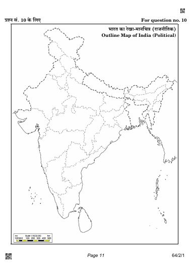
Diagram 1 – CBSE Class 12 Humanities Geography 2022 Set 2 Solutions

(1)

Ratnagiri - Iron-ore mines

[1 Mark]
Answer: The Ratnagiri Iron-ore mines are located in the Ratnagiri district of Maharashtra. These mines are significant for iron ore extraction, contributing to the region's mining industry. On the map, the Ratnagiri Iron-ore mines should be marked with an 'X' symbol to indicate their location. This area is strategically located near the western coast of India, which facilitates easy shipping and transport of iron ore. It's important to note that these mines are part of India's broader iron ore reserves, which are mainly concentrated in states like Odisha, Jharkhand, and Karnataka, but Ratnagiri's proximity to the Arabian Sea adds logistical advantages.
Key Points: Location in Ratnagiri district, Maharashtra - Mark with 'X' symbol - Importance in iron ore extraction - Proximity to Arabian Sea for shipping - Part of India's overall iron ore reserves

(2)

Jamnagar - Oil refinery

[1 Mark]
Answer: To locate and label the Jamnagar Oil Refinery on the political outline map of India, first identify its geographic position in Gujarat, situated on the western coast of the country. Use a droplet symbol to represent the oil refinery. The specific coordinates for Jamnagar are approximately 22.4668° N latitude and 69.1834° E longitude. Label the symbol clearly as 'Jamnagar Oil Refinery' for proper identification.
Key Points: Location in Gujarat-Droplet symbol-Coordinates approximately 22.4668° N, 69.1834° E-Label clearly as 'Jamnagar Oil Refinery'

(3)

Eastern-most station of the East-West Corridor

[1 Mark]
Answer: The easternmost station of the East-West Corridor is Silchar, located in the state of Assam. It serves as a crucial point that connects the eastern regions of India to the western and central parts via the extensive road networks established by the East-West Corridor. On the map, Silchar can be marked with a star symbol to denote its significance as a key transportation node.
Key Points: Easternmost station - Silchar, Assam - connects East-West Corridor - marked with a star symbol

(4)

Shimoga - Manganese mines

[1 Mark]
Answer: The Shimoga Manganese mines are located in the Shivamogga district of Karnataka. To mark this on the map, I would place a triangle symbol at the appropriate location. This area is significant for manganese production, contributing to both local industry and the overall mineral wealth of India. It is situated in the southern part of India, which is part of the broader mineral belt that stretches across Karnataka, including other regions rich in manganese.
Key Points: Location: Shivamogga district in Karnataka - Symbol: Triangle - Significance: Major manganese producer - Relation: Part of a larger mineral belt

(5)

Neyveli - Coal mines

[1 Mark]
Answer: To locate the Neyveli Coal mines on the political outline map of India, first identify the state of Tamil Nadu, which is located in the southern part of the country. The Neyveli Coal mines are situated in the Cuddalore district of Tamil Nadu. You can represent the Neyveli Coal mines using a black square symbol to signify coal mining. Make sure to label it clearly on the map, indicating its position just north of the town of Neyveli.
Key Points: Locate Neyveli in Tamil Nadu - Use a black square symbol - Label clearly on the map - Located north of Neyveli town - Cuddalore district

(6)

Southern-most metropolitan city connected by 'Golden Quadrilateral'.

[1 Mark]
Answer: The southern-most metropolitan city connected by the Golden Quadrilateral is Chennai. It is strategically located and serves as a key junction in the GQ, enhancing connectivity to other metros such as Delhi, Mumbai, and Kolkata. The city is marked as 'Chennai' on the provided map with an appropriate symbol (circle).
Key Points: Identify Chennai as the southern-most metropolitan city-Explain its connection to the Golden Quadrilateral-Use a distinct symbol to label the city on the map

Section B

Question 3.

Why are higher percentage of workers employed in services in more developed countries? Explain with examples.

[3 Marks]
Answer: In more developed countries, a higher percentage of workers are employed in services because of better economic development and urbanisation.
As countries develop, more people move away from agriculture and manufacturing jobs towards service-based jobs like teachers, lawyers, doctors, and consultants, which require skilled and professional training.
For example, in highly urbanised areas like Delhi and Chandigarh, many workers are engaged in services due to limited farming land and the growth of industries and cities.
Compared to less developed countries where many people work in farming or basic manufacturing, developed countries have advanced economies where services like banking, education, and healthcare are in high demand.
Thus, with development, employment shifts from primary and secondary sectors to the tertiary sector providing diverse and specialised services.
Key Points: Higher economic development leads to more service jobs - Urbanisation reduces farming jobs and increases service demand - Developed countries have more skilled and specialised service workers
Question 4.

"Major concentrations of modern manufacturing have flourished in a few number of places in the world." Support the statement with examples.

[3 Marks]
Answer: Major concentrations of modern manufacturing are predominantly found in regions like Western Europe and the northeastern United States. These areas account for less than 10% of the world’s land but are highly industrialized due to advanced transportation systems, skilled labor, and established infrastructure. Industries such as iron and steel, textiles, automobiles, and electronics thrive here. The growth of manufacturing in these regions has historically attracted investments and expertise, solidifying their role as global manufacturing hubs.
Key Points: Concentration in Western Europe and northeastern U.S.A.-Less than 10% of world land area-Importance of transport systems-Sectors: iron/steel, textiles, automobiles, electronics-Skilled labor and infrastructure support
Question 5.

"Cottage industry is the smallest manufacturing unit." Support the statement with examples.

[3 Marks]
Answer: Cottage industry is called the smallest manufacturing unit because the production is carried out in homes or small workshops using simple tools and local raw materials. It is usually done by artisans with the help of family members or part-time labour. For example, a man making pots in his courtyard in Nagaland or a man weaving bamboo baskets by the roadside in Arunachal Pradesh are typical examples of cottage industries. These industries produce goods mainly for local consumption or sale in village markets. Since the scale is small and capital investment is low, the influence of transportation and commercial demand is limited, which makes cottage industries unique and important for rural employment and preserving traditional skills.
Key Points: Smallest manufacturing unit - Production in homes using simple tools - Use of local raw materials - Involvement of family members or part-time labour - Examples: pottery in Nagaland, bamboo basket weaving in Arunachal Pradesh - Products for local consumption or sale
Question 6.

Why is 'access to transportation and communication' necessary for industries ? Explain.

[2 Marks]
Answer: Access to Transportation and Communication is necessary for industries because of the following reasons:
1. Transportation helps carry raw materials to factories and finished goods to markets efficiently and quickly, reducing cost and time which is essential for industrial growth.
2. Good transport facilities enable industries to get raw materials from distant places and distribute products to wider markets, which helps industries expand.
3. Communication facilities help industries to exchange information timely for management, coordination, and marketing which improves productivity.
4. Improved transportation and communication lead to regional specialisation where industries concentrate in certain areas for economic development.
Therefore, access to efficient transportation and communication systems plays a crucial role in the location, development, and success of industries.
Key Points: Transportation reduces cost and time in moving goods - Communication facilitates information exchange and management - Leads to economic development and regional specialisation
Question 7.

"Rural marketing centres cater to nearby settlements." Explain the statement.

[2 Marks]
Answer: Explanation:
Rural marketing centres are small trading hubs that mainly serve the local rural population living in nearby villages. They are known as quasi-urban centres because they are not fully developed urban areas but have some urban features.
These centres act as local collection and distribution points where farmers and rural people can sell their agricultural products and buy essential goods. They usually have mandis (wholesale markets) and retail shops to meet the daily needs of the rural community.
Personal and professional services in these centres are not highly developed, but they provide the basic services and goods required by rural people. Market days are often fixed, and the market may move from one place to another.
Thus, rural marketing centres play an important role in connecting rural producers and consumers with the wider market, supporting their economic activities and providing access to goods that are frequently needed near their settlements.
Key Points: Rural marketing centres serve nearby villages - They are quasi-urban centres - Have mandis and retail shops - Provide basic goods and services - Act as collection and distribution points - Support rural economy
Question 8.

Mention any four features of the 'North-Western Region' mineral belt in India.

[2 Marks]
Answer: The North-Western Region mineral belt in India is characterized by several distinct features. Firstly, it extends along the Aravali range in Rajasthan and part of Gujarat, indicating its geographical significance. Secondly, it is rich in important minerals such as copper and zinc, which are crucial for various industrial applications. Thirdly, Rajasthan is known for its abundant deposits of building stones, including sandstone, granite, and marble. Lastly, this region also contains deposits of gypsum and Fuller’s earth, contributing to its diverse mineral resources.
Key Points: Geographical extension along Aravali range; Rich in copper and zinc; Abundant building stones in Rajasthan; Deposits of gypsum and Fuller’s earth.
Question 9.

Mention any four characteristics of 'metallic minerals'.

[2 Marks]
Answer: Metallic minerals possess several distinct characteristics. Firstly, they are the primary sources of metals, with examples including iron ore and copper, indicating their economic significance. Secondly, they are divided into ferrous and non-ferrous minerals, where ferrous minerals contain iron, such as iron ore, while non-ferrous minerals, like copper and bauxite, do not. Thirdly, metallic minerals are unevenly distributed across different geographical regions, affecting their availability. Lastly, there tends to be an inverse relationship between the quality and quantity of metallic minerals: high-quality ores are often found in lower quantities, which impacts mining practices and resource management.
Key Points: Sources of metals; Ferrous and non-ferrous classification; Uneven geographical distribution; Inverse relationship between quality and quantity.

Section C

Question 10.

How is 'urban waste disposal' a serious problem in India? Suggest measures to solve this problem.

[5 Marks]
Answer: Urban waste disposal is a critical issue in India, particularly in metropolitan areas where rapid urbanization has outpaced infrastructural development. Approximately 90% of solid waste produced in cities like Mumbai and Bengaluru is collected; however, much of it is improperly disposed of, often being washed into drains and rivers during rainfall. The concentration of industrial units exacerbates the problem, leading to significant water pollution as industrial waste is frequently dumped into water bodies. This pollution results in severe health issues for communities downstream, including waterborne diseases. Overcrowding and insufficient sanitation facilities contribute to poor living conditions, further complicating waste management efforts. Measures to address urban waste disposal include enhancing waste segregation at the source, establishing comprehensive recycling programs, and investing in waste-to-energy projects to minimize landfill use. Improved public awareness campaigns are essential to educate citizens on waste management practices. Additionally, government policies should enforce stricter regulations on industrial waste disposal to ensure that pollutants are treated before being released into the environment. Engaging the community in sustainable practices can foster a collective responsibility toward maintaining cleaner urban spaces, thereby alleviating the urban waste crisis.
Key Points: High waste generation in metropolitan areas, Water pollution from industrial waste, Health risks due to untreated sewage, Need for better waste segregation, Importance of recycling programs, Government regulations for industrial waste, Community engagement in sustainability.
Question 11.

"Inland waterways faced many problems in India." Examine the statement with examples.

[5 Marks]
Answer: Inland waterways in India, comprising rivers, canals, and lakes, have historically been significant for transportation, yet they face numerous challenges. One major issue is the competition from road and rail transport, which has diminished the usage of inland waterways. Additionally, the diversion of river water for irrigation has rendered many waterways non-navigable, reducing their effectiveness as transport channels. For example, the Ganges faces severe navigability issues due to water extraction for agricultural purposes. Furthermore, environmental concerns such as river pollution also impede the use of these waterways, with industrial waste and sewage contaminating many rivers. Despite having 14,500 km of navigable waterways, they contribute only about 1% of India's transport sector, highlighting the need for better management and investment. Effective solutions could include improving navigability through dredging, implementing stricter pollution controls, and exploring inter-linking rivers to ensure year-round water flow. The potential for inland waterways remains significant, but addressing these challenges is critical for their development and sustainability.
Key Points: Competition from road and rail transport-diversion of river water for irrigation issues-river pollution and environmental concerns.
Question 12.

Define the term 'Trans-Continental Railways'. Explain any four characteristics of Trans-Canadian Railway.

[5 Marks]
Answer: (a) Definition of Trans-Continental Railways:
Trans-Continental Railways are railway lines that run across an entire continent, connecting its two farthest ends. These railways are constructed primarily for economic and political reasons to facilitate long-distance travel and transportation of goods in various directions across the continent.

(b) Four Characteristics of the Trans-Canadian Railway:
1. Length and Route: The Trans-Canadian Railway is approximately 7,050 km long and runs from Halifax in the east to Vancouver on the Pacific Coast in the west, passing through major cities like Montreal, Ottawa, Winnipeg, and Calgary.
2. Historical Importance: Constructed in 1886, the railway was initially built to fulfill an agreement that enabled British Columbia to join the Canadian Federation, linking the east and west coasts.
3. Economic Significance: It plays a vital economic role by connecting important agricultural and industrial regions. The railway carries key exports such as wheat and meat, making it Canada's economic artery.
4. Connectivity and Infrastructure: The railway includes a loop line from Winnipeg to Thunder Bay connecting it to one of the world's important waterways. It is double-tracked and electrified, enhancing efficiency and capacity for freight and passenger services.

Thus, the Trans-Canadian Railway is a major trans-continental railway that has contributed significantly to Canada's political unity and economic development.
Key Points: Railway across continent connecting two ends - Length of 7,050 km from Halifax to Vancouver - Built in 1886 to connect British Columbia with Canada - Important for carrying wheat and meat exports - Loop line connecting to major waterway - Double-tracked and electrified
Question 13.

Define the term 'Highways.' Explain any four points of importance of highways in North America.

[5 Marks]
Answer: Highways are metalled roads designed to facilitate easy and uninterrupted vehicle movement between distant places. They are typically eight meters wide, comprising various features like separate traffic lanes and dual carriageways to ensure smooth traffic flow. In North America, highways play a crucial role in enhancing connectivity and economic development. Firstly, they enable efficient transportation of goods and people, reducing travel time significantly. Secondly, highways stimulate economic growth by connecting cities with ports and industrial hubs, aiding trade and commerce. Thirdly, they enhance national security by allowing swift movement for defense personnel and resources. Lastly, highways also promote tourism, making it easier for travelers to explore diverse regions across the continent, contributing to local economies.
Key Points: Definition of highways as metalled roads for vehicle movement; Importance in transportation of goods and people; Role in economic growth through connectivity; Contribution to national security; Promotion of tourism and local economies

Paper Details

CBSE Board Exam 2022

Class

Class 12 Humanities

Subject

Geography

Year

2022

Set

Set 2

Other Years — Geography

2022 Set-1

2022 Set-2

2022 Set-3

2022 Set-4

2022 Set-5

2023 Set-1

2023 Set-2

2023 Set-3

2023 Set-4

2023 Set-5

2024 Set-1

2024 Set-2

2024 Set-3

2024 Set-4

2024 Set-5

2025 Set-1

2025 Set-2

2025 Set-3

2025 Set-4

2025 Set-5

2025 Set-6

CBSE Class 12 Geography 2022 Set 2 Solutions | Prepzy