SOLUTIONS
2022 BOARD EXAM
CBSE Class 12 Humanities Geography Board Paper 2022 — Set 3 Solutions
2022
Geography
Class 12 Humanities
CBSE EXAMINATION PAPER-2022
GEOGRAPHY
(Solved)
General Instructions :
Read the following instructions carefully and follow them :
- This question paper contains 13 questions. All questions are compulsory.
- This question paper is divided into 3 sections.
- Section A – questions number 1 to 2 are case based questions
- Section B – questions number 3 to 9 are short answer
- Section C – questions number 10 to 13 are long answer
- There is no overall choice given in the question paper. However, an internal choice has been provided in few questions.
- Use of calculator is NOT allowed.
Section A
Read the following source and answer the given questions:
The process of development of tribal area of Bharmaur started in 1970s when Gaddis were included among ‘scheduled tribes’. Under the Fifth Five Year Plan, the tribal sub-plan was introduced in 1974 and Bharmaur was designated as one of the five Integrated Tribal Development Projects (ITDP) in Himachal Pradesh. This area development plan was aimed at improving the quality of life of the Gaddis and narrowing the gap in the level of development between Bharmaur and other areas of Himachal Pradesh. This plan laid the highest priority on the development of transport and communications, agriculture and allied activities, and social and community services.
The most significant contribution of the tribal development sub-plan in Bharmaur region is the development of infrastructure in terms of schools, healthcare facilities, potable water, roads, communications, and electricity. But the villages located along the river Ravi in Holi and Khani areas are the main beneficiaries of infrastructural development. The remote villages in Tundah and Kugti areas still do not have sufficient infrastructure.
(1) Mention the main objective of the ‘integrated tribal development project’ in Bharmaur region.
[1 Mark](2) Explain the outcome of tribal development sub-plan in this region.
[1 Mark](3) Why is it necessary to develop infrastructural facilities for integrated development of a region? Explain.
On the given political outline map of India, locate and label any five from the following Geographical features with appropriate symbols :
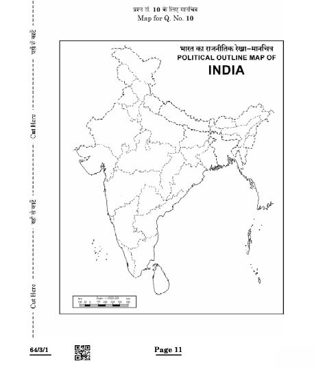
(1) Raniganj — Coal mines
This highlights its significance as a major coal mining centre in India.
(2) The southern-most station of North-South Corridor.
(3) Khetri— Copper mines
(4) The eastern-most metropolitan city connected by golden quadrilateral.
(5) Jamnagar — Oil refineries.
(6) Balaghat — Manganese mines
Section B
"The quaternary sector along with the tertiary sector has replaced most of the primary and secondary employment." Support the statement.
The quaternary sector involves knowledge-based services like information technology, research, and management. People working as CEOs, IT professionals, and medical transcriptionists belong to this sector. It focuses on collection, production, and distribution of information.
The tertiary sector includes services such as trade, transport, communication, banking, education, and health.
With economic development, many people moved away from farming and manufacturing (primary and secondary sectors) to service-oriented jobs. Over half the workers in developed economies are employed in these service sectors.
This shift is because services now have higher demand and contribute more to economic growth.
Thus, the increase in employment in quaternary and tertiary sectors and the decrease in primary and secondary sectors shows a structural change in the economy towards knowledge and services.
This supports the statement that the quaternary and tertiary sectors have replaced most primary and secondary employment.
Cottage industries are small scale industries where production is done at home using simple tools and family labour. They involve less capital investment and produce goods in small quantities. These industries use local raw materials and provide local employment.
On the other hand, large scale industries require huge capital investment and advanced technology. They use specialised skilled workers and large machinery to produce goods on a large scale. Production is done in big factories and products are meant for national and international markets.
Key Differences:
1. Scale of Production: Cottage industries produce small quantities whereas large scale industries produce large quantities.
2. Capital: Cottage industries use less capital; large scale industries need large capital.
3. Labour: Cottage industries use family or unskilled labour; large scale industries employ skilled and specialised workers.
4. Technology: Cottage industries use simple tools; large scale industries use advanced machines.
5. Location: Cottage industries are located in homes; large scale industries are located in factories.
This shows how large scale industries differ significantly from cottage industries in size, technology, production, and capital requirements.
Why is ‘technological innovation’ essential for industries ? Explain.
“Transport is an organised industry created to satisfy man’s basic need of mobility.” Support the statement.
Mention any four features of non-metallic minerals in India.
Mention any four features of ‘Geothermal energy’ in India.
Section C
Examine any five factors that are responsible for population flow from rural to urban areas in India.
Population flow from rural to urban areas in India is mainly due to certain social, economic and environmental factors. The five important factors are:
1. Search for Employment Opportunities: One of the major reasons for migration is the lack of job opportunities in rural areas. Urban areas offer better employment options in industries, services, and businesses.
2. Higher Income and Better Living Standards: People move to cities attracted by better income, improved standard of living, and availability of amenities such as healthcare, education, and recreation.
3. Educational Facilities: Urban areas have better educational institutions and facilities than rural areas. Family members, especially the younger generation, migrate to access better education.
4. Social Factors: Migration is influenced by social reasons such as joining family members, getting rid of caste restrictions, or seeking a modern lifestyle.
5. Mechanization of Agriculture: With the introduction of modern farming techniques and machines, fewer laborers are needed in rural agriculture, forcing surplus rural labor to migrate to cities in search of jobs.
Thus, these factors collectively contribute to an increasing population flow from rural to urban India, leading to rapid urbanization.
"Pipelines are the most convenient and efficient mode of transporting liquids and gases over long distances in India." Examine the statement.
Pipelines are indeed the most convenient and efficient way to transport liquids and gases over long distances in India for several reasons.
Firstly, pipelines provide a continuous and uninterrupted flow of materials such as water, petroleum, natural gas, and even liquidified coal. This reduces dependency on other slower modes of transport like road or rail.
Secondly, pipelines are safer and cause less pollution compared to transport by road or rail. They have fewer chances of accidents or spills and reduce the risk of theft or damage.
Thirdly, pipelines are cost-effective in the long run. Although the initial cost of laying pipelines is high, the maintenance and operational cost is low, making it economical for transporting large quantities.
Fourthly, pipelines require less manpower and have minimal impact on the environment. They help in reducing traffic congestion by lowering the number of tankers and trucks needed.
In India, Oil India Limited (OIL) and other organisations operate extensive networks of oil and gas pipelines which help in the efficient supply of energy resources across the country.
Moreover, pipelines can even transport solids converted into slurry, increasing their utility.
To conclude, pipelines are the most suitable mode for transporting liquids and gases over long distances in India due to their efficiency, safety, cost-effectiveness, and environmental benefits.
"Road transport is the most economical for short distances compared to railways in the world." Support the statement.
1. Door-to-Door Service: Road transport provides direct door-to-door delivery of passengers and goods. This reduces loading and unloading costs and time, making it more efficient for short distance travel.
2. Flexibility and Accessibility: Roads connect remote and rural areas where railways may not reach. This makes road transport more accessible and practical for shorter trips.
3. Cost-effective for Short Distances: For short distances, the cost of constructing and maintaining railway infrastructure is not practical. Roads are simpler and cheaper to build and maintain for short routes.
4. Time Efficiency: For short distances, road transport is faster as it does not require fixed schedules like trains. Vehicles can start their journey immediately without waiting.
5. Volume of Traffic: Approximately 85 percent of passengers and 70 percent of freight in many countries are transported by road annually, showing its dominance especially in short distances.
6. Suitability for Less Bulk Goods: Road transport is better for transporting smaller loads or less bulky goods over short distances.
In conclusion, while railways are ideal for long distances and heavy goods, road transport offers an economical, flexible, and time-saving solution for short distance travel and freight movement, making it the preferred choice worldwide for such purposes.
Waterways have been used as a means of transport since ancient times. Inland waterways such as rivers, canals, lakes, and coastal areas are important channels for transporting cargo and passengers. One of the greatest advantages of waterways is that they do not require the construction of roads or railways, which reduces infrastructure costs. Water transport is very fuel-efficient and eco-friendly because water causes less friction than land, thus consuming less energy.
Water transport is also the cheapest mode for carrying heavy and bulky goods over long distances, making it economically beneficial. For example, India has about 14,500 km of navigable waterways, which contribute around 1% to its total transport capacity. The navigability of waterways depends on factors like channel depth and width, continuous water flow, and the technology used.
Although waterways face competition from roads and railways, their ability to carry large volumes cost-effectively remains crucial. Oceanic waterways connect countries worldwide and require only port facilities at the start and end. Thus, waterways are vital for both inland and international trade and passenger travel, providing an efficient and sustainable transport option.
Paper Details
CBSE Board Exam 2022
Class
Class 12 Humanities
Subject
Geography
Year
2022
Set
Set 3
Other Years — Geography