Section B
[1 Mark]
-
(A) Only I, II and III
-
(B) Only II, III and IV
-
(C) Only I, III and IV
-
(D) Only I, II and IV
Explanation: The correct answer is 'Only I, II and III'. According to the provided context, the branches of the Dravidian language family are South Dravidian and Central Dravidian. However, East Dravidian is not mentioned as a branch, making only I (Central Dravidian), II (East Dravidian), and III (South Dravidian) a valid combination based on classifications provided.
[1 Mark]
-
(A) Both (A) and (R) are true, but (R) is not the correct explanation of (A).
-
(B) (A) is correct, but (R) is incorrect.
-
(C) Both (A) and (R) are true and (R) is the correct explanation of (A).
-
(D) (A) is incorrect, but (R) is correct.
Explanation: Both (A) and (R) are true, and (R) is the correct explanation of (A). The context states that there is indeed an inverse relationship between the quality and quantity of minerals, confirming that good quality minerals are less abundant compared to lower quality ones, which directly supports the assertion.
[1 Mark]
-
(A) National Highways Authority of India
-
(B) Border Roads Organisation
-
(C) State Public Works Department
-
(D) Central Public Works Department
Explanation: The correct answer is 'Border Roads Organisation' because the context states that this organization has constructed roads in high altitude mountainous terrain, specifically mentioning the road that joins Chandigarh with Manali and Leh, indicating their role in this project.
[1 Mark]
-
(A) Public Transport with Ring Railway
-
(B) Carpooling with Metro Rail
-
(C) Metro Rail with CNG Buses
-
(D) Ring Railway with CNG Buses
Explanation: The correct option is 'Metro Rail with CNG Buses.' This combination is effective for controlling air pollution as the Metro Rail provides a mass rapid transit solution that reduces the number of vehicles on the road, thereby minimizing emissions. Additionally, CNG buses are a cleaner alternative to diesel or petrol vehicles, further contributing to lower air pollution levels.
[1 Mark]
-
(A) Welfare Approach
-
(B) Capability Approach
-
(C) Income Approach
-
(D) Basic Needs Approach
Explanation: The correct option is 'Welfare Approach'. This approach views human beings as beneficiaries or targets of all development activities, emphasizing the role of government in increasing human development through welfare expenditures.
[1 Mark]
-
(A) Mixed Farming
-
(B) Co-operative Farming
-
(C) Plantation Agriculture
-
(D) Extensive Commercial Grain Cultivation
Explanation: The correct answer is 'Extensive Commercial Grain Cultivation' because this type of agriculture is explicitly mentioned in the context as being well-developed in the Australian Downs. It is characterized by large farm sizes and the mechanized cultivation of crops such as wheat, which aligns with the description provided in the context.
[1 Mark]
-
(A) Secondary
-
(B) Primary
-
(C) Tertiary
-
(D) Quaternary
Explanation: The correct answer is 'Secondary' because secondary activities are specifically concerned with manufacturing, processing, and construction industries, which transform raw materials into finished products. This is noted in the context that states secondary activities add value to natural resources by transforming them into valuable products.
[1 Mark]
-
(A) Rural Marketing Centres
-
(B) Retail Trading
-
(C) Urban Marketing Centres
-
(D) Wholesale Trading
Explanation: The correct answer is 'Retail Trading.' This is because retail trading involves the sale of goods directly to consumers, and automatic vending machines and internet sales are forms of non-store retail trading, where purchases are made directly by the consumer without a physical store.
[1 Mark]
-
(A) Both growth and development are always positive.
-
(B) Growth may be positive or negative, but development is always positive.
-
(C) Development may be positive or negative, but growth is always positive.
-
(D) Both growth and development may be positive or negative.
Explanation: Growth may be positive or negative, but development is always positive. This is because growth refers to quantitative changes that can show increases or decreases, while development signifies a qualitative change that inherently requires a positive enhancement in conditions and cannot occur without positive growth.
[1 Mark]
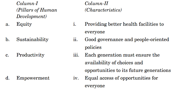
-
(A) a iii, b iv, c ii, d i
-
(B) a iii, b iv, c i, d ii
-
(C) a iv, b iii, c ii, d i
-
(D) a iv, b iii, c i, d ii
Explanation: The correct option is a iv, b iii, c ii, d i This matches the natural and cultural features with their respective classifications in the context provided. 'i' aligns with the identification of patterns, 'ii' pertains to distribution, 'iii' and 'iv' refer to labor classifications and the nature of work based on color of the collar, which are correctly matched.
[1 Mark]
-
(A) Only I, III and IV are correct.
-
(B) Only II, III and IV are correct.
-
(C) Only I, II and III are correct.
-
(D) Only I, II and IV are correct.
Explanation: The correct answer is 'Only I, II and IV are correct.' because tertiary activities involve all types of services (I), include trade, transport, and communication (II), and examples consist of various service providers like teachers and lawyers (IV). Statement III is incorrect as tertiary activities do not involve the transformation of raw materials into finished goods; this is characteristic of secondary activities.
[1 Mark]
-
(A) Goods and services travel faster and move farther
-
(B) Goods and services move farther
-
(C) Goods and services travel faster
-
(D) Better connectivity only in a region concerned
Explanation: The correct option is 'Goods and services travel faster and move farther.' This is supported by the context which states, 'With the development of transport and communication systems, goods and services can travel faster and farther than ever before,' highlighting the impact of these systems on the efficiency and reach of trade.
[1 Mark]
-
(A) Entire area to the right side of main canal
-
(B) Entire area north of Jaisalmer district
-
(C) Entire area to the left side of main canal
-
(D) Entire area south of Bikaner district
Explanation: The correct option is 'Entire area to the right side of main canal' because, according to the context provided, all the lift canals of the Indira Gandhi Canal system originate at the left bank of the main canal, while the canals on the right bank are flow channels.
[1 Mark]
-
(A) Both (A) and (R) are true and (R) is the correct explanation of (A).
-
(B) (A) is incorrect, but (R) is correct.
-
(C) (A) is correct, but (R) is incorrect.
-
(D) Both (A) and (R) are true, but (R) is not the correct explanation of (A).
Explanation: Both (A) and (R) are true and (R) is the correct explanation of (A) because the context explains that India's population distribution varies significantly due to various factors such as geography, socio-economic conditions, and historical influences, which supports the assertion of uneven population distribution.
[1 Mark]
-
(A) Policy Formulator
-
(B) Insurance Provider
-
(C) Teacher
-
(D) Bank Clerk
Explanation: The correct answer is 'Policy Formulator.' Gold Collar professionals are highly skilled individuals who hold senior positions and possess specialized knowledge, such as business executives and consultants. In the context provided, these include roles involving significant responsibilities and advanced expertise, which aligns with the nature of a Policy Formulator.
[1 Mark]
-
(A) Trade liberalisation
-
(B) Trade restriction
-
(C) Trade value
-
(D) Trade quantity
Explanation: The correct option is 'Trade liberalisation' because the context states that free trade is defined as the act of opening up economies for trading, which is referred to as trade liberalisation. It emphasizes reducing trade barriers like tariffs to allow goods and services to compete in the market.
[1 Mark]
-
(A) Developed countries
-
(B) Developing countries
-
(C) Both under-developed and developed countries
-
(D) Both developed and developing countries
Explanation: The correct answer is 'Developing countries'. The context highlights that globalization and free trade can adversely affect the economies of developing countries by imposing unfavorable conditions and not providing an equal playing field. This leads to challenges such as competition from richer countries and potential harm to domestic producers due to cheaper, dumped goods.
Section C
[3 Marks]
Answer: The uneven distribution of modern manufacturing industries globally can be attributed to several key factors. Firstly, geographical advantages play a significant role, with industries often located near resources like raw materials and energy sources, leading to cost efficiency. Secondly, historical development has led to the concentration of industries in developed regions, particularly in North America and Europe, where a skilled workforce and advanced infrastructure already exist. Additionally, advances in technology and capital investment are more pronounced in economically developed areas, allowing for the establishment of large-scale manufacturing units. Lastly, the urbanization trend facilitates access to labor markets and transport facilities, further skewing industrial distribution toward urban centers. These factors collectively create a scenario where manufacturing is concentrated in specific regions rather than being evenly distributed across the globe.
Key Points: Geographical advantages; historical development; concentration in developed regions; access to skilled labor; technological advancement; capital investment; urbanization trends; transportation facilities
[3 Marks]
Answer: Industries can be classified based on their products into two main categories: basic industries and consumer goods industries. Basic industries, such as iron and steel, produce raw materials that are utilized in manufacturing other goods. These industries are essential for the production processes of various sectors. On the other hand, consumer goods industries focus on producing items directly consumed by the end-users, like food products (breads, biscuits) and electronics (televisions). Basic industries typically require heavier investments and are foundational to an economy, while consumer goods industries are more diverse and cater to daily needs.
Key Points: Classification into basic and consumer goods industries-basic industries produce raw materials-consumer goods industries produce direct consumer products-importance of basic industries in production processes-diversity of consumer goods industries in meeting daily needs
[3 Marks]
Answer: Humans rely on natural resources for survival and well-being, exemplified by food, clothing, and shelter. Primitive societies depended on their immediate environments, gathering edible plants and hunting animals. As societies advanced, they learned to cultivate crops and rear livestock, utilizing land, soil, and water as essential resources. Additionally, forests provide timber and medicinal plants, while water bodies supply fish and support agriculture. Our cultural practices, such as clothing suited to weather conditions, further illustrate this dependency on nature's bounty.
Key Points: Direct dependence on nature for survival, examples of food and clothing, cultivation of crops, utilization of land and water, cultural adaptation to environment
[3 Marks]
Answer: Water quality refers to the physical, chemical, and biological characteristics of water, determining its suitability for various uses including drinking, recreation, and irrigation. In India, surface water quality is deteriorating due to various factors. Firstly, indiscriminate usage of water for agricultural and industrial purposes results in contamination. The discharge of pollutants from factories, along with untreated sewage, significantly increases the levels of harmful substances. Additionally, agricultural runoff containing fertilizers raises nitrate concentrations. Cultural activities further elevate pollution levels, impacting health and ecosystems. Therefore, most surface water bodies in India are not safe for consumption.
Key Points: Definition of water quality; Factors contributing to poor surface water quality; Indiscriminate water use; Industrial discharge and sewage contamination; Agricultural runoff and fertilizers; Cultural activities causing pollution; Conclusion on safety for consumption
Section D
[5 Marks]
Answer: The statement that urban centres in India are more differentiated in terms of socio-economic, politico-cultural, and other development indicators is indeed valid. Urban centres like Mumbai and Delhi showcase stark contrasts in wealth, infrastructure, and cultural representation. For instance, while affluent localities in Mumbai, such as South Mumbai, boast high-rise apartments and modern amenities, areas like Dharavi highlight socio-economic struggles. Politically, urban settings experience diverse party representations, influencing their socio-cultural landscape. Additionally, urban centres attract a booming rural-urban migration due to enhanced employment opportunities and improved living conditions. In contrast, most rural areas largely depend on agriculture with limited economic diversity. The differentiation within urban centres illustrates the complexities of urban development, where some areas thrive while others lag, influenced by socio-economic factors and urban planning initiatives. Furthermore, this variation showcases the socio-political dynamics at play, where urban centres act as engines of growth while still reflecting disparities and inequalities.
Key Points: 1. Differential socio-economic statuses in urban centres like Mumbai and Delhi. 2. Urban areas exhibit stark contrasts between affluent and impoverished localities. 3. Political representations in urban settings show diversity affecting socio-cultural dynamics. 4. Significant rural-urban migration to urban centres for better opportunities. 5. Rural areas predominantly rely on agriculture with limited economic diversity. 6. Urban centres reflect complexities of growth, highlighting inequalities and disparities.
[5 Marks]
Answer: Land degradation is predominantly driven by human activities rather than natural processes, making it a more pressing concern. Human actions like deforestation for plantation crops, overgrazing of pastures, and mining contribute significantly to land degradation. For instance, the clearing of forests for agriculture not only destroys habitats but also leads to soil erosion and loss of fertility, exemplified by regions in India facing severe deforestation. Moreover, industrial wastelands often arise due to improper waste management and land use, further exacerbating land quality issues. Faulty irrigation practices cause problems such as salinisation and waterlogging, which severely affect agricultural productivity. Research indicates that while natural processes contribute to land degradation, the scale and severity of human-induced degradation overshadow them, making sustainable land management essential to prevent the conversion of fertile lands into wastelands. Therefore, it is critical to address human factors in land degradation to preserve agricultural productivity and environmental integrity.
Key Points: Human activities lead to significant land degradation; Examples include deforestation for agriculture, overgrazing, and mining; Industrial wastelands due to improper management; Faulty irrigation causes salinisation and waterlogging; Natural processes are overshadowed by human impact; Importance of sustainable land management.
[5 Marks]
Answer: Indian farming practices can primarily be classified into two categories based on the source of moisture: irrigated farming and rainfed farming (barani). Irrigated farming aims to provide sufficient soil moisture during the cropping season to achieve high productivity and is subdivided into protective irrigation, which safeguards crops against adverse weather conditions, and productive irrigation, which focuses on maximizing yields. Protective irrigation is utilized in areas where annual rainfall is less than 75 cm, enabling the cultivation of hardy crops like ragi, bajra, moong, and gram, using techniques such as soil moisture conservation and rainwater harvesting. In contrast, rainfed farming depends entirely on rainfall, and is further divided into dryland and wetland farming. Dryland farming occurs in arid regions with limited rainfall, while wetland farming thrives in areas with excess moisture during the rainy season, often resulting in floods. This method supports water-intensive crops like rice, jute, and sugarcane and may involve aquaculture practices in freshwater bodies. Ultimately, these classifications underscore the diversity of agricultural methods in India shaped by climatic conditions.
Key Points: Classification based on moisture source; Irrigated farming (protective and productive); Rainfed farming (dryland and wetland); Protective irrigation for soil safeguard; Specific crops for dryland vs. wetland; Techniques like soil moisture conservation and rainwater harvesting; Aquaculture practices.
[5 Marks]
Answer: Common Property Resources (CPRs) are natural resources owned collectively by a community, allowing access and usage rights to all members without individual ownership. Examples include community forests, pasture lands, and village water bodies. CPRs play a vital role in the livelihoods of landless and marginal farmers, who depend on these resources for fodder and fuel. With limited land access, many families rely on their livestock for income derived from these shared resources. Moreover, women often bear the responsibility of collecting fuel and fodder from CPRs, engaging in labor that supports household needs. The sustainable management of CPRs ensures not only the availability of essential resources but also strengthens community ties and economic resilience among the most vulnerable sections of society. Overall, CPRs provide a safety net, supporting food security and maintaining local livelihoods, thus sustaining the rural economy.
Key Points: Definition of Common Property Resources; Examples of CPRs (community forests, pasture lands, water bodies); Importance of CPRs to landless/marginal farmers; Role of CPRs in livestock income; Significance for women in resource collection; Sustainable management leading to community and economic resilience
[5 Marks]
Answer: Population distribution across the world is influenced by various factors that determine how people are spread over the Earth’s surface. Geographic factors, such as climate, landforms, and natural resources, significantly impact where populations settle. Areas with fertile land and favorable climates, such as river valleys, tend to be densely populated. Economic opportunities also play a key role, with urban centers attracting people for jobs. Additionally, cultural aspects, such as historical migration patterns and community ties, affect population density. Political stability and government policies shape migration trends, leading to variations in population distribution. Regions with conflict or instability often experience lower populations, while peaceful areas attract more residents. Therefore, the intricate interplay of environmental, economic, cultural, and political factors leads to the uneven distribution of the global population, emphasizing the importance of these elements in understanding demographic patterns.
Key Points: Geographic factors like climate and natural resources, Economic opportunities in urban areas, Cultural influences from historical migration, Political stability affecting migration trends, The interplay of these factors leading to uneven global population distribution
[5 Marks]
Answer: Migration is the process by which people relocate from one place to another, driven by various factors in search of improved living conditions, economic opportunities, or safety. It can be permanent, temporary, or seasonal and involves a movement from a place of origin to a place of destination. Push factors, such as unemployment, political instability, and poor living conditions in the place of origin, make it less attractive for residents. Conversely, pull factors, like better job prospects, security, and a favorable climate at the destination, attract migrants, resulting in population growth in the new location. Understanding these factors helps to explain population dynamics and migration patterns.
Key Points: Definition of migration-Push factors: unemployment, poor living conditions, political turmoil-Pull factors: better job opportunities, security, pleasant climate-Impact on population distribution.
[5 Marks]
Answer: The composition of India's imports has witnessed significant changes from 2015 to 2022. Historically, India has relied heavily on imports of crude petroleum, precious stones, and metals. However, the trend indicates a gradual decline in the share of capital goods and food products. The import of crude petroleum remains a prominent contributor, reflecting the energy needs of an expanding economy. The steady growth in non-ferrous metals and precious commodities highlights India's shift towards higher-value imports. This change is also influenced by the country's industrial policies and the rising demand for technology and machinery in manufacturing. Meanwhile, the decline in agriculture and food imports showcases improvements in domestic production capabilities. Additionally, the overall volume of imports has increased, outpacing exports, further indicating a growing trade deficit. Consequently, policy focus must address the implications of these trends on India's economy and strive to enhance export competitiveness alongside managing import dependency.
Key Points: Changing import composition; Decline in capital goods and food imports; Rise in crude petroleum and precious stones; Increase in total import volume; Trade deficit implications; Impact on domestic production capabilities; Policy focus required for enhancing export competitiveness.
[5 Marks]
Answer: The Trans-Canadian Railway, completed in 1886, is a monumental 7,050 km rail line that runs from Halifax in the east to Vancouver on the west coast of Canada. This railway was primarily constructed to facilitate the joining of British Columbia to the Canadian Confederation, addressing both political and economic needs. As the economic artery of Canada, it connects major cities including Montreal, Ottawa, Winnipeg, and Calgary, enabling the efficient transport of goods, notably wheat and meat. Additionally, the railway features a vital loop line from Winnipeg to Thunder Bay, which connects to important waterways. Remarkably, the Trans-Canadian Railway is one of the longest double-tracked, electrified rail lines in the world, enhancing its efficiency and capacity. Its role in opening up Canada’s vast regions to trade has been significant, fostering economic development and integration across the continental area. Overall, this railway is not just a transportation route but a crucial lifeline for Canada’s economy, linking diverse regions and enabling the trade of essential commodities.
Key Points: 7,050 km length connecting Halifax to Vancouver; constructed in 1886 for political and economic purposes; major cities include Montreal, Ottawa, Winnipeg, Calgary; facilitates export of wheat and meat; features a loop from Winnipeg to Thunder Bay; one of the longest double-tracked and electrified railways; significant for trade and economic integration.
[5 Marks]
Answer: The Trans-Siberian Railway is a vital rail route that connects St. Petersburg in the west to Vladivostok in the east, stretching approximately 9,332 kilometers, making it the longest railway line in the world. This double-tracked and electrified line passes through significant cities like Moscow, Ufa, Novosibirsk, Irkutsk, Chita, and Khabarovsk. It has played a crucial role in facilitating trade and opening up the Asian region to West European markets. The railway crosses the Ural Mountains and significant rivers, including the Ob and Yenisei. The line connects with other important routes, extending to cities in Ukraine, Uzbekistan, Mongolia, and China, enhancing regional and international connectivity. In Russia, rail transport is paramount, covering about 90% of the country's land transport, with Moscow serving as the central hub.
Key Points: Connects St. Petersburg to Vladivostok, longest railway in the world, passes through major cities, double-tracked and electrified, supports trade with West European markets, crosses significant geographical features, links to other regional and international routes, crucial for Russian transport system.