Class 9 . Social Science . Understanding Society India and Beyond Part I . Shaping of the Earth S Surface
Chapter 2: Shaping of the Earth’s Surface
Ch 2
Social Science
Class 9
Plate Tectonics Part-1
Landform — A landform is a natural feature of Earth’s surface shaped by processes such as weathering, erosion, deposition and movement of Earth’s crust.
Examples of landforms
- Examples: Mountains, valleys, plateaus, plains, deserts and coastal features.
Plate Tectonics
Plate tectonics — The theory, given by W.J. Morgan, explains how pieces of Earth’s outer layer move and shape the surface.
Core idea
- Tectonic plates: Earth’s outermost solid layer is divided into large and small slabs rather than forming one continuous piece.
- Movement: Plates move slowly over the semi-molten layer beneath them, generally by a few centimetres per year.
- Effects: Their movement helps form mountains, volcanoes and other landforms, and causes earthquakes.
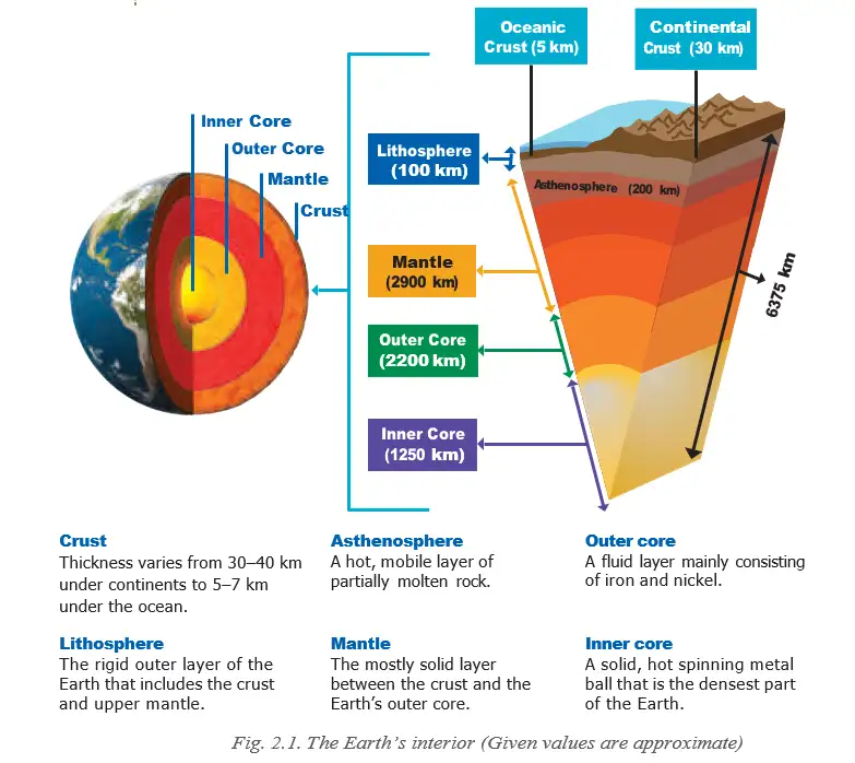
| Layer | Position / description |
|---|---|
| Crust | Outermost layer; the surface on which we live. |
| Mantle | Very thick, hot layer below the crust. |
| Core | Innermost, extremely hot and heavy layer. |
| Lithosphere | Crust plus the upper part of the mantle; broken into tectonic plates. |
| Asthenosphere | Semi-molten layer beneath the lithosphere; allows plates to move. |
| Type | What it carries |
|---|---|
| Continental | Continents |
| Oceanic | Ocean floors |
| Mixed | Both continents and oceans |
Major tectonic plates
- Major plates: Pacific, Eurasian, African, North American, South American, Indo-Australian and Antarctic.
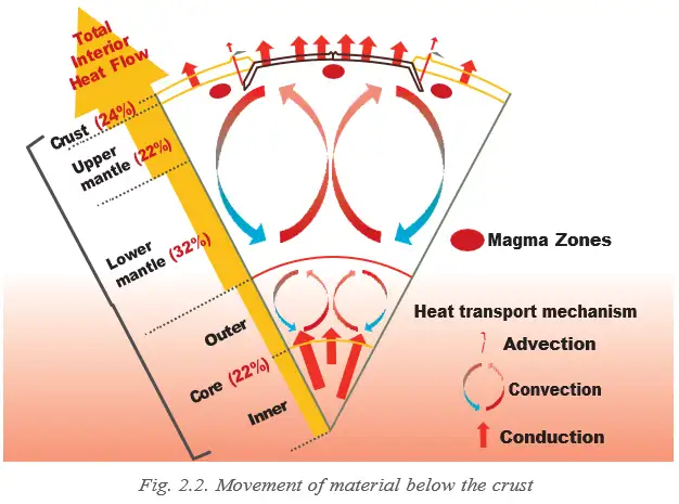
Plate Movement and Boundaries
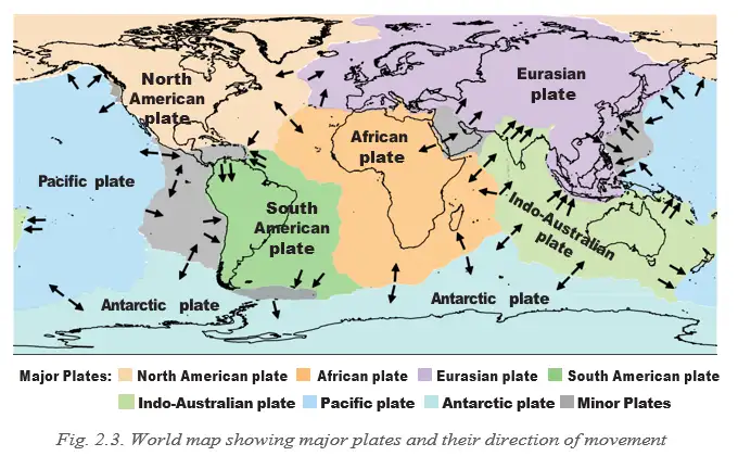
Convection currents move plates
- Heat from Earth’s core warms mantle material.
- Hot, molten material rises while cooler material sinks.
- This continuous circulation creates convection currents in the mantle.
- The currents push and pull tectonic plates, moving them in different directions.
Plate boundary — The edge where two tectonic plates meet.
| Boundary | Plate movement | Main result | Example |
|---|---|---|---|
| Convergent | Plates move towards each other. | Continental collision forms fold mountains. An oceanic plate sinking beneath a continental plate can cause volcanoes and earthquakes. | Himalaya (continental collision) |
| Divergent | Plates move away from each other. | Magma rises and forms new crust, creating features such as mid-ocean ridges. | Mid-Atlantic Ridge |
| Transform | Plates slide past each other. | Crust is neither created nor destroyed; movement mainly causes earthquakes. | San Andreas Fault, United States |
How Plate Tectonics Shapes Earth
Landforms and natural hazards
- Surface features: Plate movement contributes to the formation of mountains, valleys, ocean basins and volcanoes.
- Continents and oceans: Plate tectonics helps explain their distribution across Earth.
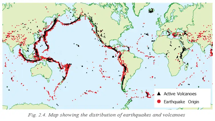
- Earthquakes and volcanoes: Most occur along plate boundaries, especially around the Pacific Ocean in the region called the Ring of Fire.
- Lithosphere
- The crust and upper mantle, divided into tectonic plates.
- Asthenosphere
- The semi-molten layer beneath the lithosphere that allows plates to move.
- Convection currents
- Circulating mantle movement caused by hot material rising and cooler material sinking.
- Ring of Fire
- The region around the Pacific Ocean where many earthquakes and volcanoes occur.
How do convection currents cause tectonic plates to move?
What correlation is seen between plate boundaries, earthquakes and volcanoes?
Quick recap
- Earth’s lithosphere is divided into tectonic plates that move slowly over the asthenosphere.
- The crust, mantle and core are Earth’s three main interior layers.
- Convection currents in the mantle drive plate movement.
- Convergent, divergent and transform boundaries produce different landforms and hazards.
- Plate movement shapes mountains, ocean basins and other surface features.
- Most earthquakes and volcanoes occur along plate boundaries, especially in the Ring of Fire.
Plate Tectonics Part-2
Why Plate Tectonics Matters
Uses of the Theory
- Plate tectonics explains how Earth’s surface changes and how many landforms and natural disasters originate.
- Hazard mapping helps identify regions prone to earthquakes and volcanoes.
- Disaster management can use these risk zones to prepare for and reduce the effects of natural disasters.
Earthquake Risk in India
Hazard and Human Impact
- India’s experience: Major earthquakes have caused thousands of deaths.
- Risk: A large earthquake in a densely populated area can severely damage lives and the environment.
- Vulnerability: Earthquake-prone regions face greater risk; dense population can increase the number of people affected.
Earthquake Example
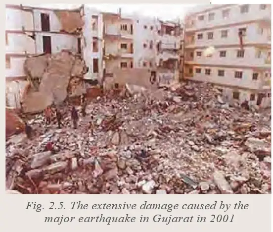
- 2001A major earthquake caused severe damage in Gujarat.
Early Indian Understanding of Earthquakes
- Bhūkampa means the shaking of the Earth.
- Bṛihatsaṁhitā: Varāhamihira dedicated a section to earthquakes and described possible signs such as changes in wind, rain, clouds, animal behaviour and planetary alignments.
- Four forces: Vāyu (wind), Agni (fire), Indra (heaven/thunder) and Varuṇa (water) were linked to particular constellations and regions.
- Significance: This account reflects an early Indian attempt to combine observations with cosmological reasoning about physical phenomena.
Volcanic Eruptions and Surface Effects
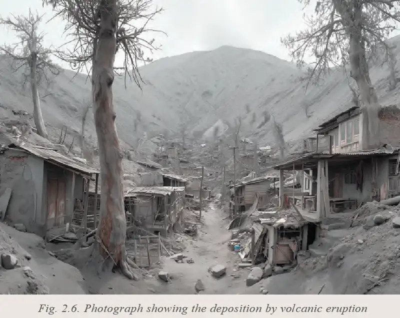
- Eruption deposits: Volcanic ash and debris can settle around villages after an eruption.
- Earth’s internal forces: These deposits show how processes inside Earth can affect the surface and nearby communities.
| Point | Fiery volcanoes | Mud volcanoes |
|---|---|---|
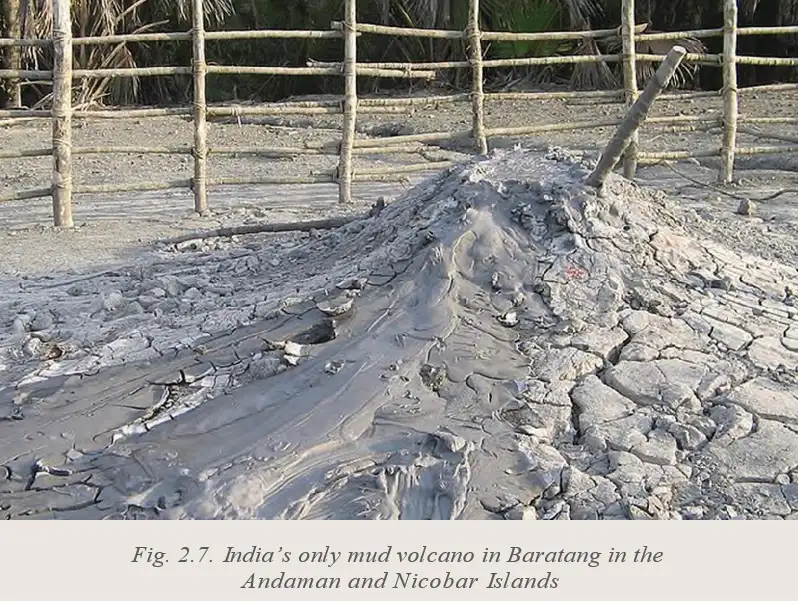
| Material released | Volcanic ash and debris may be deposited during eruptions | Mud bubbles out |
| Cause described | Volcanic eruption | Natural underground gases and pressure |
| Example | Volcanic deposits around a village after an eruption | Baratang Island, Andaman and Nicobar Islands |
- Earthquake-prone region
- An area at greater risk of experiencing earthquakes.
- Volcanic ash
- Fine material deposited around an area after a volcanic eruption.
- Mud volcano
- A feature where mud bubbles out under pressure from natural underground gases.
Quick recap
- Plate tectonics explains changing landforms and helps identify earthquake- and volcano-prone areas.
- Earthquakes can cause severe loss of life and environmental damage, especially in densely populated areas.
- The 2001 Gujarat earthquake illustrates the destructive impact earthquakes can have on buildings.
- Varāhamihira’s account combined observations of possible earthquake signs with cosmological reasoning.
- Volcanic eruptions can leave ash and debris around settlements.
- Baratang Island has a mud volcano driven by underground gases and pressure.
Process of Weathering and Erosion
How Weathering and Erosion Shape the Surface
- Together: Weathering breaks down rock, while erosion transports material; over time, they reshape mountains, valleys and plains.
- Landforms: These processes also help form caves, cliffs and river deltas.
Weathering
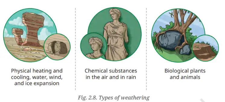
Weathering — The breakdown of rocks at the Earth’s surface into smaller pieces, without movement of the broken material.
| Type | Cause | Example or result |
|---|---|---|
| Physical | Temperature changes, frost or wind | Rock breaks into smaller pieces. |
| Chemical | Reactions with water, air or acids | Rock minerals change and form new substances. |
| Biological | Plants, animals or micro-organisms | Plant roots grow into cracks and split rocks. |
Why Weathering Matters
- Role: Weathering helps shape the Earth’s surface and contributes to soil formation.
Erosion
Erosion — The wearing away and movement of soil, rocks and other surface material from one place to another by natural agents.
| Type | Agent or cause | Where or how it acts |
|---|---|---|
| Water | Rivers, rain or ocean waves | Wears away and transports surface material. |
| Wind | Moving wind | Common in dry, sandy areas. |
| Glacial | Moving ice | Ice scrapes and carries rocks. |
| Coastal | Sea waves | Wears away land along the shore. |
| Point | Weathering | Erosion |
|---|---|---|
| Main process | Breaks rock into smaller pieces. | Wears away and transports material. |
| Movement | Broken material stays in place. | Material is carried to another place. |
| Agents | Temperature, frost, wind, chemical reactions and living things. | Water, wind, ice and waves. |
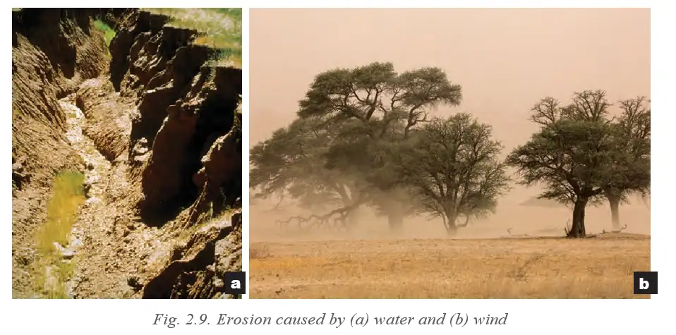
Effects of Erosion on People and Livelihoods
| People or occupation | Effect of erosion |
|---|---|
| Farmers | Loss of fertile topsoil reduces crop yields. |
| River- and coastal-area residents | Erosion can wash away land, houses and roads, causing property loss. |
| Construction and mining workers | Unstable land creates safety risks. |
| Tourism and fishing | Damage to beaches, rivers and fertile lands can harm these industries. |
Soil and Water Conservation Practices
Traditional and Integrated Practices
- Sindhu-Sarasvatī civilisation: Used contouring, bunding, terracing, dams and canals for water management.
- Written knowledge: The Vedas, Kṛiṣhiparāśhara, Kauṭilya’s Arthaśāstra and Vṛikṣhāyurveda document these practices.
- Arthaśāstra: Includes guidance on assessing and classifying land by fertility and productivity.
- Zabo system: An integrated farming approach in Nagaland that uses earthen bunds on hillslopes to conserve soil and water.
- Check dams: Built across small streams to slow water, limit soil erosion, encourage sediment deposition and support groundwater recharge.
| Practice | How it works |
|---|---|
| Contouring / continuous contour trench (CCT) | Trenches follow hillside contour lines, slowing and holding rainwater so it can infiltrate; this reduces erosion and recharges groundwater. |
| Bunding | Earthen embankments along contour lines slow surface run-off, reduce erosion and increase water infiltration and soil moisture. |
| Terracing | Creates level or gently sloping steps on hillsides to prevent soil erosion. |
- Weathering
- Breakdown of rock in place, without transport.
- Erosion
- Wearing away and transport of surface material.
- CCT
- Continuous contour trench; a trench dug along a hillside contour to conserve water and soil.
- Zabo system
- Nagaland’s integrated farming approach using earthen bunds to conserve soil and water.
- Check dam
- A small-stream structure that slows water and helps reduce erosion.
How do weathering and erosion differ?
Name the main types of weathering and give an example of biological weathering.
How does erosion affect farmers and how can contour trenches help?
Quick recap
- Weathering breaks rocks down in place; erosion transports worn material.
- Weathering may be physical, chemical or biological.
- Water, wind, ice and waves are agents of erosion.
- Erosion can damage farmland, settlements, infrastructure and livelihoods.
- Contouring, bunding, terracing and check dams help conserve soil and water.
- The Zabo system is an integrated soil- and water-conservation approach in Nagaland.
Agents of Gradation Part-1
Agents of Gradation
Agents of gradation — Natural forces that wear down, transport and deposit materials, gradually lowering high areas and filling low areas.
Main agents and their effects
- Main agents: Running water, glaciers, wind, waves and groundwater.
- Running water: Erodes rocks and soil, forming valleys and plains.
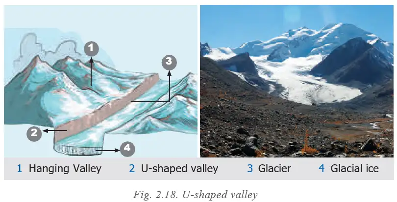
- Glaciers: Scrape and carry large quantities of material, carving U-shaped valleys.
- Wind and waves: Wind erodes and deposits sand; waves reshape coastlines.
- Groundwater: Dissolves rocks such as limestone, forming caves and sinkholes.
| Landform | Influence and example |
|---|---|
| Rivers and fertile plains | The Ganga, Nile, Brahmaputra and Indus supported agriculture and early cities. |
| Mountains | The Himalayas acted as a barrier and protection, while passes such as the Khyber Pass enabled cultural exchange. |
| Deserts | The Thar limited large settlements but encouraged trade routes such as the Silk Route. |
| Coasts and harbours | They supported trade, travel and cultural contacts, helping kingdoms in south India flourish. |
Running Water
River processes — Rivers shape the land through erosion, transportation and deposition along their course.
| River course | Conditions and typical landforms |
|---|---|
| Upper | Steep gradient and strong erosion; V-shaped valleys, waterfalls and rapids. |
| Middle | Meandering flow and increasing deposition; meanders, oxbow lakes and floodplains. |
| Lower | Slower flow and abundant deposition; deltas, levees and alluvial fans. |
Waterfalls
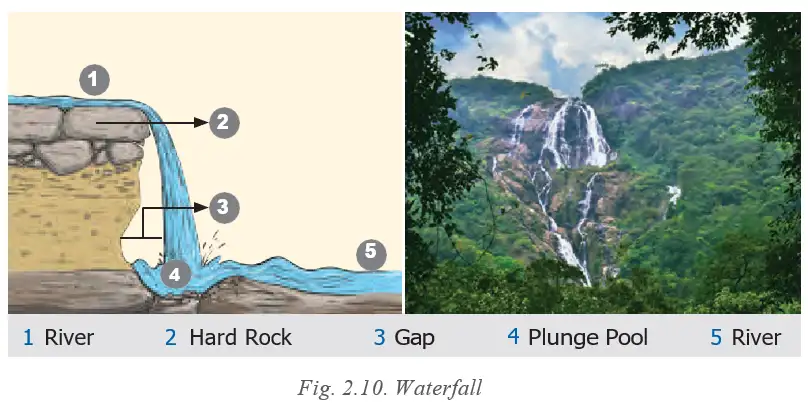
Waterfall — A landform where a river flows over a steep cliff or vertical drop.
Formation and importance
- Formation: In the upper course, hard rock resists erosion while softer rock below wears away, creating a sudden drop.
- Uses and importance: Waterfalls attract tourists, support recreation and may be used to generate hydroelectric power.
- Cultural value: Some waterfalls have cultural or religious significance.
Meanders
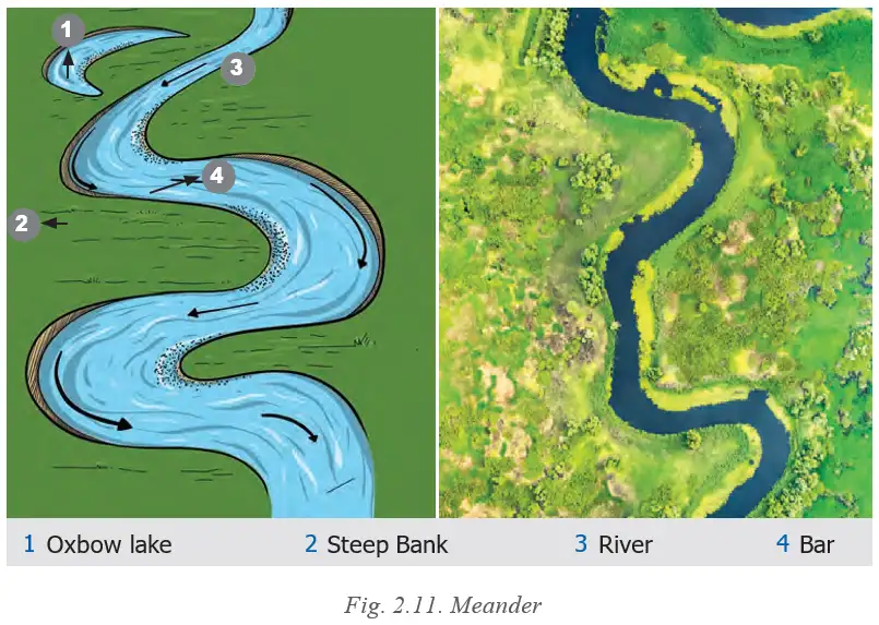
Meander — A winding curve or bend in a river, usually in its middle or lower course, formed by lateral erosion and deposition.
Formation and importance
- Outer bank: The river erodes the outside of a bend, forming a steep bank.
- Inner bank: The river deposits sediment on the inside, forming a bar.
- Over time: Continued erosion and deposition enlarge the bends; cut-off loops can leave oxbow lakes.
- Human importance: Fertile soil supports farming; nearby gentle slopes attract settlements. Rivers may also support navigation, irrigation and tourism.
- Example: The Grand Anicut, also known as Kallanai, in Tamil Nadu is used for irrigation.
Deltas
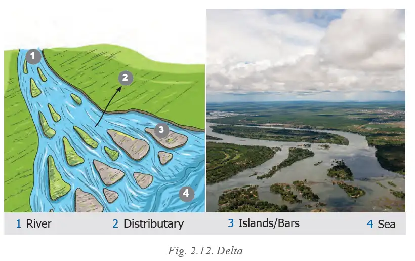
Delta — A fan-shaped or triangular area formed by sediment deposited where a river enters a sea, ocean or lake.
Features and importance
- Formation: The river deposits sediment at its mouth; deposits accumulate and the river may divide into distributaries.
- Soil and livelihoods: Fertile alluvial soil supports crops such as rice and jute; mixed fresh and salt water supports aquatic life and fishing.
- Settlement and trade: Deltas support dense settlements and can become trade and transport centres because rivers provide navigable routes.
- Risk: Deltas are prone to flooding, which can affect people and their activities.
Waves, Currents and Beaches
Coastal shaping
- Waves and currents: Their constant movement reshapes land along the coastal zone.
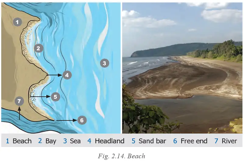
- Coastal landforms: Their action forms beaches, sand bars, sea cliffs, sea caves, arches and stacks.
Beach — A shoreline landform of sand, pebbles or rocks, formed mainly by wave deposition.
Beach formation and importance
- Shaping: Waves, tides and currents move and deposit material along the coast, continually changing beaches.
- Human uses: Beaches support tourism, recreation and fishing; some coastal communities collect sand and shells.
- Natural protection: Beaches can reduce the force of strong waves and help protect settlements from coastal erosion.
Coastal Erosion Landforms
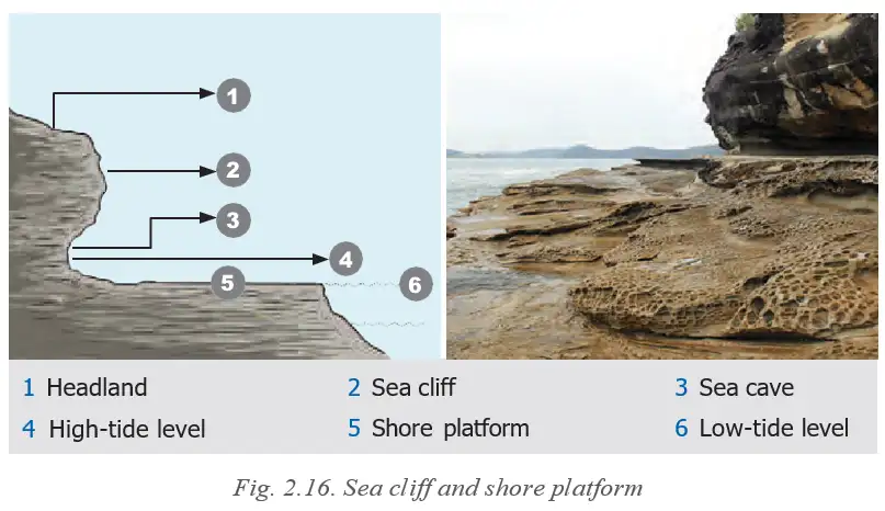
Coastal erosion — The wearing away of coastal land by waves, tides and currents.
| Landform | How it forms |
|---|---|
| Sea cliff | Waves undercut the coast at its base, leaving a steep rock face. |
| Wave-cut platform | A relatively flat area left as a sea cliff retreats. |
| Sea cave | Forms when waves erode a weak part of the rock. |
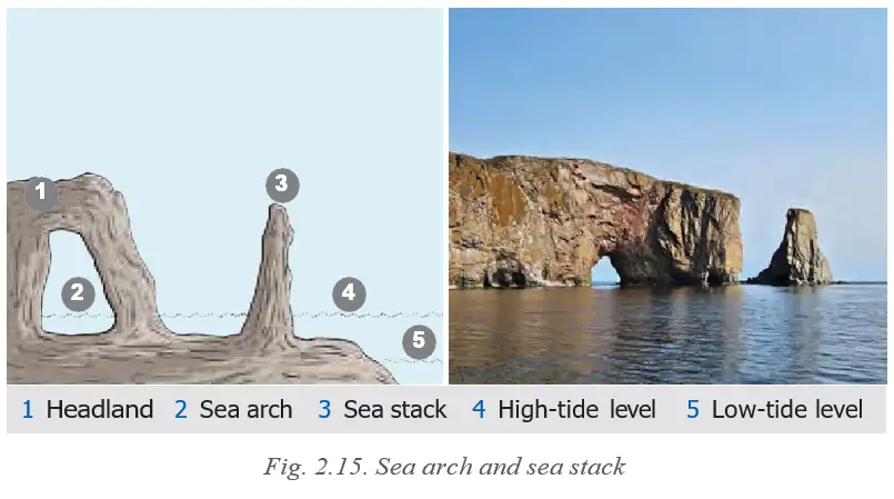
| Sea arch | Forms when caves eroding from opposite sides of a headland meet. |
| Sea stack | An isolated rock pillar left after an arch collapses. |
Formation of a Sea Arch and Stack
- Waves erode weak sections of a headland → caves form.
- Caves deepen and meet through the headland → an arch forms.
- The arch roof collapses → an isolated sea stack remains.
- Erosion
- Wearing away of rock or soil by natural agents.
- Transportation
- Movement of eroded material from one place to another.
- Deposition
- Laying down of transported material when an agent loses energy.
- Distributary
- A channel branching away from a river, commonly across a delta.
- Alluvial soil
- Fertile soil formed from river-deposited sediments.
How does a waterfall form?
How are meanders formed?
How do coastal arches and stacks form?
Quick recap
- Gradation agents erode, transport and deposit material, gradually reshaping the Earth's surface.
- River landforms vary by course: upper-course valleys and waterfalls, middle-course meanders and floodplains, and lower-course depositional features.
- Waterfalls form where hard rock resists erosion while softer rock below wears away.
- Meanders form through erosion on outer banks and deposition on inner banks; deltas form through deposition at river mouths.
- Waves and currents deposit beach material and erode coasts into cliffs, platforms, caves, arches and stacks.
- Landforms influence settlement, farming, trade, transport and other human activities.
Agents of Gradation Part-2
Glaciers
Moraines
Why moraines matter
- Fertile soil: Moraine deposits can support agriculture.
- Water resources: Moraines can form natural dams and lakes used for water supply and irrigation.
- Energy: Some moraine-created lakes can be used for hydroelectric power.
Wind
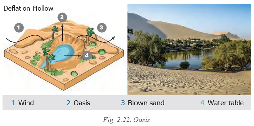
Sand Dunes
Why dunes matter
- Protection: Dunes can act as barriers against desertification and wind erosion.
- Coastal defence: Coastal dunes can protect settlements from strong winds and waves.
- Uses: Dunes support tourism and adventure sports; their sand is sometimes used for construction.
Underground Water and Karst Topography
| Point | Stalactites | Stalagmites |
|---|---|---|
| Position | Hang from the cave ceiling. | Rise from the cave floor. |
| Shape | Icicle-shaped. | Grow upward from the floor. |
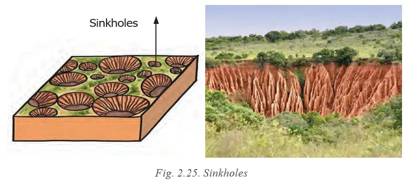
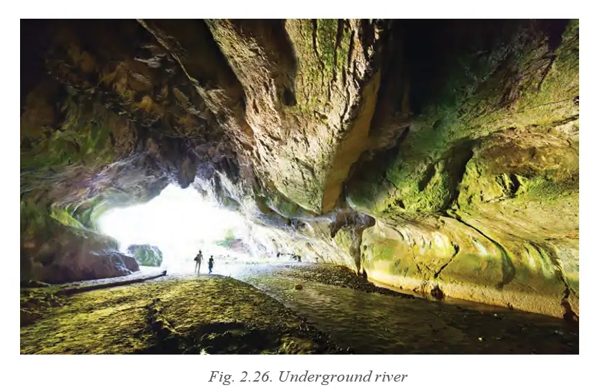
Why karst landforms matter
- Water: Caves and underground rivers can provide fresh water.
- Tourism and study: Caves and their formations attract visitors, geologists and adventurers.
- Cultural significance: Some caves have cultural or religious importance.
Quick recap
- Glaciers erode land to form U-shaped valleys, cirques, arêtes, hanging valleys and fjords.
- Moraines are glacial deposits of till; lateral, terminal and medial moraines differ by position and formation.
- Wind erosion forms yardangs, ventifacts, deflation hollows and desert pavements.
- Wind deposits sand to form dunes, including barchan, longitudinal, star and parabolic types.
- Underground water dissolves soluble rock and creates karst features such as caves, sinkholes and underground rivers.
- Stalactites hang from cave ceilings, while stalagmites rise from cave floors.
Landforms and Disasters
Landslides
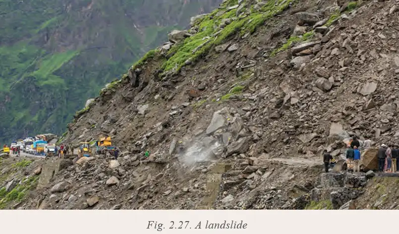
Landslide — The sudden movement of rock, soil, or debris down a slope when the slope becomes unstable.
Causes and risk factors
- Heavy, continuous rain: Water saturates soil and rocks, increasing their weight and reducing friction.
- Natural triggers: Earthquakes and volcanic eruptions shake the ground and weaken slopes.
- Slope conditions: Steep slopes and loose or weathered rocks increase the risk of slope failure.
- Human causes: Deforestation, mining, road construction, and unplanned hillside construction disturb slope stability.
- Water and land use: Poor drainage and improper land use allow excess water to accumulate and trigger sudden failure.
How a landslide occurs
- Heavy rain, shaking, or human disturbance weakens a slope
- Water and gravity reduce the slope’s stability
- Rock, soil, or debris moves downhill
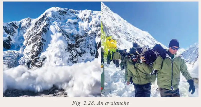
Avalanches
Avalanche — The sudden movement of unstable snow down a steep mountain slope.
Causes and triggers
- Heavy snowfall: Snow added quickly increases the snowpack’s weight, especially over weak or loosely bonded layers.
- Temperature rise: Sudden warming can partially melt snow and reduce the friction holding it together.
- Strong winds: Unevenly piled snow can form fragile layers.
- Natural disturbances: Earthquakes and vibrations can disturb snow-covered slopes.
- Human triggers: Skiing, trekking, and construction in mountain areas can destabilise snow.
How an avalanche occurs
- Heavy snowfall, melting, wind, or disturbance destabilises snow on a steep slope
- Weak snow layers lose their balance
- Snow suddenly moves downhill
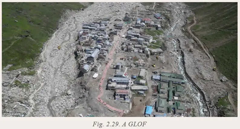
Glacial Lake Outburst Floods (GLOFs)
Glacial Lake Outburst Flood (GLOF) — A destructive flood caused by the sudden release of water stored in a glacial lake.
Causes and triggers
- Glacier melt: Rising temperatures can rapidly melt glaciers, enlarging lakes and raising their water levels.
- Natural dams: Greater water pressure can threaten lake dams made of ice or loose moraines.
- Extra water: Heavy rain or intense snowfall can add more water to a glacial lake.
- Dam failure triggers: Earthquakes, avalanches, or landslides may strike the lake or weaken its dam.
How a GLOF occurs
- Glacier melt or added rain and snowfall raises the lake’s water level
- Water pressure builds against the natural ice or moraine dam
- A disturbance weakens or collapses the dam
- Stored water rushes downstream, causing destructive floods
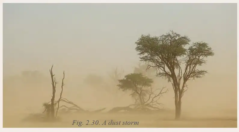
Dust Storms
Dust storm — A storm in which strong winds lift large amounts of loose, dry soil and sand into the air.
Causes and risk factors
- Dry soil: Prolonged drought and low rainfall dry out soil, making fine particles easier for wind to lift.
- Prone environments: Dust storms are common in desert and semi-arid regions with loose, dry soil.
- Sparse vegetation: Deforestation, overgrazing, and poor farming practices reduce plant cover and expose soil.
- Climate factors: Climate change and extreme weather can increase the frequency and intensity of dust storms.
How a dust storm forms
- Drought, low rainfall, or loss of vegetation leaves soil dry and exposed
- Strong winds pick up loose soil and sand
- Dust and sand are carried through the air as a storm
Quick recap
- Landslides occur when slopes are weakened by water, natural shaking, unstable materials, or human activity.
- Avalanches happen when snow on steep slopes becomes unstable due to heavy snowfall, melting, wind, or disturbances.
- GLOFs result when a glacial lake’s natural dam fails and releases stored water downstream.
- Glacier melt, heavy rain or snowfall, earthquakes, avalanches, and landslides can contribute to GLOFs.
- Dust storms form when strong winds lift loose, dry soil and sand, especially in desert and semi-arid regions.
- Drought, sparse vegetation, deforestation, overgrazing, poor farming, and extreme weather raise dust-storm risk.
Summary
Forces That Shape the Earth
Earth’s Structure and Surface Processes
- Layers: The Earth consists of the crust, mantle and core.
- Internal forces: Earthquakes, volcanic eruptions, folding and faulting move the crust and create major landforms.
- External processes: Weathering, erosion and deposition gradually wear down and reshape the surface.
- Agents of gradation: Running water, waves and tides, glaciers, wind and underground water carve landforms.
- Human connection: Landforms affect climate, resources, settlements and cultures.
Landforms and Natural Disasters
- Landform-related hazards: Landslides, avalanches, glacial lake outflows and sandstorms are associated with specific landforms.
- Why study landforms: Understanding the Earth’s surface helps people appreciate natural processes and prepare for natural disasters.
Quick recap
- The Earth has three main layers: crust, mantle and core.
- Earthquakes, volcanic eruptions, folding and faulting are internal forces that move the crust.
- Weathering, erosion and deposition reshape the surface; running water, waves and tides, glaciers, wind and underground water act as agents of gradation.
- Landforms influence climate, resources, settlements and cultures.
- Landslides, avalanches, glacial lake outflows and sandstorms are hazards associated with specific landforms.
Social Science — ALL CHAPTERS
1
The French Revolution
2
Socialism In Europe And The Russian Revolution
3
Nazism And The Rise Of Hitler
4
Forest Society And Colonialism
5
Pastoralists In The Modern World
1
Understanding Social Science
2
Shaping of the Earth’s Surface
3
Atmosphere and Climate
4
Early Humans and Beginning of Civilisation
5
State and Society up to 1000 CE
6
Democracy
7
Elections
8
Building Blocks in Economics: The Problem of Choice
9
The Price Puzzle: What Drives the Market