Class 12 Humanities . History . Themes In Indian History Part II . An Imperial Capital Vijayanagara C Fourteenth to Sixteenth Century
Chapter 3: AN IMPERIAL CAPITAL VIJAYANAGARA (C. FOURTEENTH TO SIXTEENTH CENTURY)
Ch 3
History
Class 12 Humanities
Introduction & the Discovery of Hampi
Vijayanagara and Hampi
The Discovery of Hampi
Mackenzie: Work and Viewpoint
- Career: Born in 1754, Mackenzie was an engineer, surveyor and cartographer. He became the first Surveyor General of India in 1815 and held the post until his death in 1821.
- Purpose: He collected local histories and surveyed historic sites to understand India’s past and to assist the East India Company’s governance.
- Colonial viewpoint: Mackenzie described British rule as a “benign influence” after earlier “bad management”; this reflected a colonial perspective rather than a neutral account.
- Local assistants: The painting’s caption names his peon Kistnaji, holding a telescope, and Brahmana assistants, including a Jaina pandit and the Telugu Brahmana Cauvellery Ventak Letchmiah.
How does the painting portray Mackenzie and his indigenous informers?
Key Dates
- 1336Tradition and epigraphic evidence credit Harihara and Bukka with founding the Vijayanagara Empire.
- Fifteenth centuryThe Gajapati ruling lineage was powerful in Orissa.
- 1498The Portuguese arrived on the west coast and attempted to establish trading and military stations.
- 1565Vijayanagara was sacked; the city was subsequently deserted.
- Seventeenth–eighteenth centuriesThe city fell into ruin.
- 1754Colin Mackenzie was born.
- 1800Mackenzie brought Hampi’s ruins to light and prepared the site’s first survey map.
- 1815–1821Mackenzie served as the first Surveyor General of India.
- 1836Epigraphists began collecting inscriptions at Hampi and other temples.
- 1856Photographers began recording Hampi’s monuments.
Rayas, Nayakas and Sultans
| Title | Meaning | Associated rulers |
|---|---|---|
| Gajapati | Lord of elephants | A ruling lineage powerful in fifteenth-century Orissa |
| Ashvapati | Lord of horses | Deccan Sultans in Vijayanagara popular traditions |
| Narapati | Lord of men | Vijayanagara rayas in popular traditions |
Building on Earlier Traditions
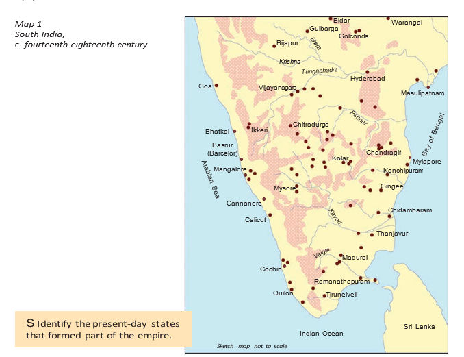
- Earlier states: Areas incorporated into Vijayanagara had seen powerful states, including the Cholas in Tamil Nadu and the Hoysalas in Karnataka.
- Temple patronage: Earlier ruling elites supported elaborate temples, including Brihadishvara at Thanjavur and Chennakeshava at Belur.
- Vijayanagara rulers: The rayas built on these traditions and developed them further.
Kings and Traders
Trade, Warfare and State Power
- Warfare depended on effective cavalry
- → imported horses from Arabia and Central Asia became strategically important
- → Arab traders initially controlled the horse trade, with kudirai chettis also participating
- → from 1498, Portuguese traders and military forces became additional actors in regional politics
- → trade in horses and other valuable goods contributed to the state’s prosperity
What sources helped historians reconstruct Vijayanagara’s history?
Why were horses and overseas trade important to Vijayanagara?
- Krishna-Tungabhadra doab
- The region between the Krishna and Tungabhadra rivers.
- Epigraphist
- A scholar who studies inscriptions.
- Karnataka samrajyamu
- The name contemporaries used for the empire historians call Vijayanagara.
- Kudirai chettis
- Local merchants who participated in the horse trade.
Quick recap
- Vijayanagara means “city of victory”; at its height, the empire stretched from the Krishna river to the peninsula’s southern tip.
- Hampi’s rediscovery drew on local oral traditions and archaeological, epigraphic and written sources.
- Colin Mackenzie surveyed Hampi with local assistance; his writings reflected a colonial viewpoint.
- Harihara and Bukka are traditionally credited with founding the empire in 1336; its rulers were called rayas.
- Vijayanagara competed with neighbouring powers while also exchanging architectural ideas with them.
- Imported horses were important for cavalry, while trade in horses and other valuable goods supported state prosperity.
The Apogee and Decline of the Empire
Ruling Dynasties and Krishnadeva Raya
Krishnadeva Raya’s Expansion
- 1509–1529Krishnadeva Raya ruled; his reign was marked by expansion and consolidation.
- 1512Vijayanagara acquired the Raichur doab, between the Tungabhadra and Krishna rivers.
- 1514The rulers of Orissa were subdued.
- 1520The Sultan of Bijapur suffered a severe defeat.
Achievements and Prosperity
- Military strength: The kingdom remained prepared for war while experiencing considerable peace and prosperity.
- Building: Krishnadeva Raya built temples and added impressive gopurams to important South Indian temples.
- Nagalapuram: He founded this suburban township near Vijayanagara and named it after his mother.
- Accounts of the city: Some of the most detailed descriptions of Vijayanagara date from his reign or shortly afterwards.
Imperial Strain and the Fall of Vijayanagara
Decline and Change of Capital
- 1529Krishnadeva Raya died; his successors faced rebellions by nayakas.
- By 1542Central power had shifted to the Aravidu ruling lineage.
- 1565At Rakshasi-Tangadi (Talikota), Rama Raya’s army was defeated by the combined armies of Bijapur, Ahmadnagar and Golconda.
- Within a few years after 1565The sacked city of Vijayanagara was abandoned; the empire’s focus shifted east.
From Political Strain to the Abandonment of the City
- Krishnadeva Raya’s death in 1529 → rebellious nayakas challenged his successors.
- Rama Raya pursued an adventurous policy of playing one Sultan against another → the Deccan Sultanates combined against Vijayanagara.
- The allied forces of Bijapur, Ahmadnagar and Golconda defeated Rama Raya at Rakshasi-Tangadi in 1565 → Vijayanagara was sacked.
- The city was abandoned within a few years → the Aravidu rulers moved their centre east, first to Penukonda and later to Chandragiri near Tirupati.
Relations with the Deccan Sultanates
| Point | Cooperation / intervention | Conflict / rivalry |
|---|---|---|
| Nature of relations | Relations were not always hostile despite religious differences. | Shifting military alliances and ambitions could lead to war. |
| Examples | Krishnadeva Raya supported claimants in the Sultanates and used the title “establisher of the Yavana kingdom”. The Sultan of Bijapur also intervened in Vijayanagara succession disputes after Krishnadeva Raya’s death. | Rama Raya’s policy of setting one Sultan against another prompted the Sultanates to unite against Vijayanagara. |
| Underlying concern | Vijayanagara rulers and the Sultans each sought stability in the other’s state. | Rival ambitions could override earlier cooperation. |
Kings, Trade and Military Power
Amuktamalyada — A Telugu work on statecraft composed by Krishnadeva Raya.
Why the King Encouraged Trade
- Imports: Krishnadeva Raya urged rulers to improve harbours and encourage imports such as horses, elephants, precious gems, sandalwood and pearls.
- Military purpose: Good horses and elephants strengthened the army; keeping these goods from enemies supported the kingdom’s security.
- Foreign traders: The king advised welcoming foreign sailors in difficulty and attracting merchants with audiences, gifts and fair profits.
- Beneficiaries: The king and army gained access to valuable supplies; merchants gained trade and profits, while port communities and other traders benefited from commerce.
Yavana — A Sanskrit term used for Greeks and other peoples who entered the subcontinent from the north-west.
The Rayas and the Nayakas
- Nayaka
- A military chief, often controlling forts and armed followers; many spoke Telugu or Kannada.
- Amara-nayaka
- A military commander granted a territory by the raya to govern and collect revenue.
- Amara-nayaka system
- Vijayanagara’s political and military arrangement in which amara-nayakas governed territories and maintained troops.
- Iqta system
- A system of the Delhi Sultanate from which features of the amara-nayaka system were likely derived.
Nayakas and Their Relationship with the King
- Power and movement: Nayakas usually controlled forts and armed supporters; they could move between regions, sometimes with peasants seeking fertile land.
- Submission and rebellion: Many accepted the raya’s authority, but some rebelled and had to be subdued by military action.
- System’s significance: The amara-nayaka system was a major political innovation of Vijayanagara; some features likely came from the Delhi Sultanate’s iqta system.
| Role or duty | What it involved |
|---|---|
| Grant | The raya assigned a territory to a military commander. |
| Revenue collection | Amara-nayakas collected taxes and dues from peasants, craftspersons and traders. |
| Use of revenue | They kept part for personal use and maintained a required contingent of horses and elephants; some revenue supported temples and irrigation works. |
| Service to the king | Their troops strengthened the royal army and helped extend Vijayanagara control across the southern peninsula. |
| Tribute and loyalty | They sent annual tribute and attended the royal court with gifts. |
| Royal control | Kings sometimes transferred nayakas from one territory to another to assert authority. |
| Later change | During the seventeenth century, many nayakas established independent kingdoms, hastening the collapse of central imperial authority. |
Meaning of “Amara” and Nayaka Centres
- Possible origins: “Amara” is thought to derive from Sanskrit *samara* (“battle” or “war”); it also resembles the Persian *amir* (“high noble”).
- Centres of nayaka power: Chandragiri, Madurai, Ikkeri, Thanjavur and Mysore were centres associated with nayaka authority.
- Geography and communication: Rivers and hills could facilitate or hinder travel between these centres and Vijayanagara, depending on routes and terrain.
Why did the Vijayanagara rulers encourage foreign trade?
What caused the defeat of Vijayanagara at Rakshasi-Tangadi in 1565, and what followed?
How did the amara-nayaka system support Vijayanagara’s rulers?
Quick recap
- The Sangama, Saluva, Tuluva and Aravidu dynasties successively held central power.
- Krishnadeva Raya expanded the empire and promoted temples, prosperity and trade.
- After his death, nayaka rebellions and Sultanate alliances weakened the empire.
- Rama Raya’s defeat at Talikota in 1565 led to Vijayanagara’s sack and abandonment.
- Relations between the rayas and Sultans included both cooperation and conflict.
- Amara-nayakas governed territories, collected revenue and maintained military contingents; many later became independent.
Vijayanagara the Capital and Its Environs
The City and Its Zones
Physical layout
- Setting: Vijayanagara lay in a natural basin around the Tungabhadra River, enclosed by rocky granite hills and crossed by streams.
- Zones: The city plan shows three major areas: the Sacred Centre, the Royal Centre and the urban core.
- Paes’s account: The city was so vast and spread among several hills that it could not be seen from one viewpoint; he described gardens, water channels, lakes and fruit trees near the palace.
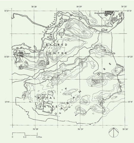
Evidence for Reconstructing the City
Inscriptions and travellers
- Inscriptions: Records of kings and nayakas document temple donations and significant events.
- Fifteenth-century visitors: Nicolo de Conti (Italian trader), Abdur Razzaq (Persian ruler’s ambassador) and Afanasii Nikitin (Russian merchant) visited the city.
- Sixteenth-century visitors: Portuguese travellers Duarte Barbosa, Domingo Paes and Fernao Nuniz left accounts of Vijayanagara.
Travellers and City Works
- Fifteenth centuryNicolo de Conti, Abdur Razzaq and Afanasii Nikitin visited Vijayanagara.
- Early fifteenth centuryThe major reservoir now known as Kamalapuram tank was built.
- Sixteenth centuryDuarte Barbosa, Domingo Paes and Fernao Nuniz visited or wrote about the city.
Water Resources
Reservoirs, canals and aqueducts
- Need for storage: Vijayanagara was in an arid part of the peninsula, so embankments across streams formed reservoirs to store rainwater.
- Kamalapuram tank: Water irrigated nearby fields and was channelled to the Royal Centre.
- Hiriya canal: A dam across the Tungabhadra diverted water to irrigate the cultivated valley between the Sacred Centre and the urban core; it was apparently built by Sangama rulers.
- Aqueducts: Water channels and aqueducts carried water across uneven ground into parts of the city.
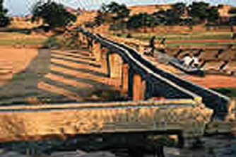
A royal tank described by Paes
- Krishnadeva Raya’s tank: Built where two hills met, it gathered runoff and received water through pipes from a lake more than three leagues (about 15 kilometres) away.
- Waterworks: Paes described three large carved pillars connected to pipes that supplied water for irrigating gardens and rice fields.
- Scale: Paes reported that about 15,000–20,000 people worked on the tank’s construction.
Fortifications and Roads
Fortified city
- Seven lines of forts: Abdur Razzaq described seven fortification lines enclosing the city, its agricultural hinterland and forests.
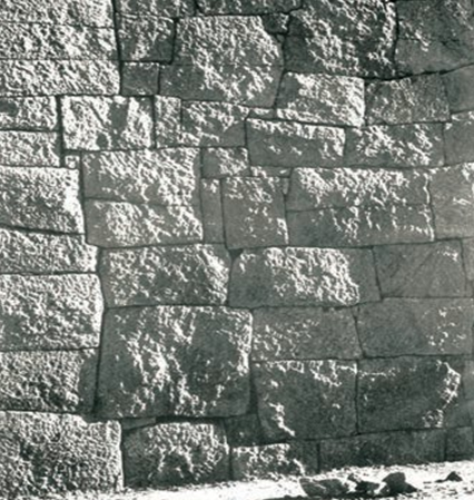
- Construction: The outer wall linked surrounding hills. Wedge-shaped stone blocks held together the tapered masonry without mortar; the wall’s inner core was packed earth and rubble, with projecting square or rectangular bastions.
- Layers of defence: Further walls enclosed the inner urban area and then the Royal Centre; groups of major buildings inside it could have their own walls.
- Protected farmland: Cultivated fields, gardens and houses lay between the outer walls. Archaeological evidence also confirms farmland between the Sacred Centre and urban core.
Why Protect Agricultural Land?
- Medieval sieges could last for months or years.
- Attackers could try to starve the defenders into surrender.
- Vijayanagara’s rulers enclosed cultivated land as well as the city.
- The protected agricultural belt and its canals helped maintain food supplies during a siege.
Gates and roads
- Gates: Well-guarded gateways connected the fortified areas to major roads and controlled access.
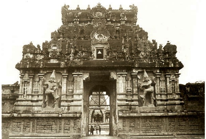
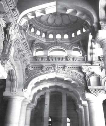
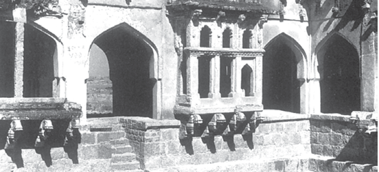
- Indo-Islamic features: Arches and domes on gateways are regarded as features introduced by Turkish Sultans. Art historians call this style Indo-Islamic; it developed through continuing interaction with local building practices.
- Roads: Archaeologists traced routes through gateways and pavement remains. Roads generally followed valleys to avoid rocky ground.
- Bazaars: Some important roads extended from temple gateways and were lined with markets.
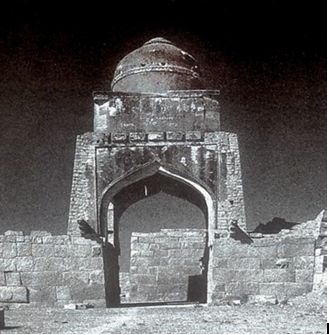
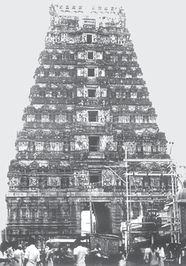
| Point | Fort gateway | Temple gopuram |
|---|---|---|
| Main role | Controlled entry through the fortification | Marked the entrance to a temple |
| Typical features | Arch and dome; associated with Indo-Islamic forms | Tall, tiered and decorated tower; characteristic of South Indian temples |
| Architectural significance | Shows architectural forms associated with Turkish Sultans and interaction with local practices | Shows a distinct temple gateway form |
Indo-Islamic architecture
- Style: Arches and domes at gateways are associated with architectural forms introduced by Turkish Sultans.
- Development: Art historians use the term Indo-Islamic for this style, which developed through interaction with local building practices in different regions.
The Urban Core
People, homes and water
- Ordinary houses: Few remains survive. Barbosa described thatched but well-built houses arranged in long streets by occupation, with open spaces.
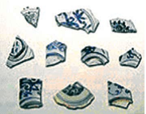
- Rich traders: Finds of fine Chinese porcelain, especially in the north-eastern urban core, suggest that wealthy traders lived there.
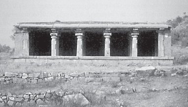
- Muslim residential quarter: This area contained tombs and mosques. Although their functions differed, their architecture resembled Hampi temple mandapas.
- Religious life: Numerous shrines and small temples suggest that different communities supported a variety of cults.
- Water for residents: Wells, rainwater tanks and temple tanks may have served as water sources for ordinary town dwellers.
- Sacred Centre
- The zone containing temples and other religious structures.
- Royal Centre
- The zone containing royal buildings and associated structures.
- Urban core
- The city area with residential quarters, streets, shrines and other urban features.
- Indo-Islamic architecture
- An architectural style shaped by interaction between Turkish architectural forms and local building practices.
Why were agricultural tracts enclosed within Vijayanagara’s fortifications?
What evidence helps historians reconstruct Vijayanagara’s layout and life?
What were the main features of Vijayanagara’s water-management system?
Quick recap
- Vijayanagara’s main zones were the Sacred Centre, Royal Centre and urban core, set within a hilly basin by the Tungabhadra.
- Inscriptions, travellers’ accounts and archaeological remains are key sources for studying the city.
- Tanks, embankments, canals and aqueducts stored and distributed scarce water.
- Multiple fortification lines enclosed the city, hinterland and farmland; protected agriculture helped meet the danger of long sieges.
- Roads followed valleys, passed through guarded gateways and often connected temple entrances to bazaars.
- The urban core included ordinary homes, wealthy traders, a Muslim quarter, shrines and possible local water sources.
The Royal Centre
Location, Buildings and Royal Authority
The royal centre was not exclusively a palace or residential area: it also contained many temples.
The Audience Hall and Mahanavami Dibba
Mahanavami Festival and Royal Power
Festival as a Display of Kingship
- Autumn Mahanavami festival
- Rituals, performances and processions take place
- The king’s prestige, power and suzerainty are displayed
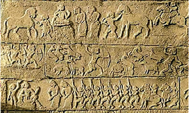
- The king inspects armies; nayakas offer gifts and tribute
Other Buildings in the Royal Centre
Elevation — A vertical view of a structure, showing features that may not be visible in a photograph.
Plan — A horizontal view of a structure.
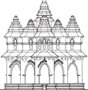
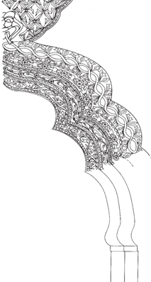
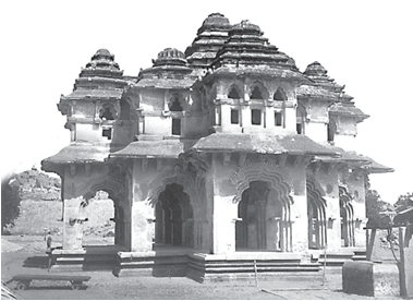
The Elephant Stables
- Name and evidence: The nearby complex is known as the “elephant stables”; its elevation and plan show its form, but the name alone does not prove its precise use.

Hazara Rama Temple and Nayaka Building Traditions
How did the Mahanavami festival reinforce the king’s authority?
Why is the function of the Lotus Mahal uncertain?
Why might the nayakas have continued Vijayanagara’s palatial building traditions?
- Suzerainty
- Supreme authority exercised over subordinate rulers or territories.
- Mahanavami dibba
- A massive raised platform associated with royal Mahanavami ceremonies.
- Nayaka
- A subordinate chief or ruler who served the king and owed tribute.
- Elevation
- A vertical view of a structure.
- Plan
- A horizontal view of a structure.
Quick recap
- The south-western royal centre included about 30 palace complexes and more than 60 temples; temple patronage helped legitimise royal authority.
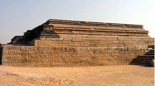
- Paes called the audience hall and mahanavami dibba together the “House of Victory”; the uses of several structures remain uncertain.
- The mahanavami dibba was a large platform, and the festival’s ceremonies displayed royal power, prestige and suzerainty.
- The Lotus Mahal’s function is uncertain; Mackenzie’s map suggests it may have been a council chamber.
- An elevation is a vertical view; a plan is a horizontal view of a structure.
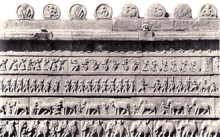
- The Hazara Rama temple was probably used by the royal family and preserves Ramayana panels; nayakas continued Vijayanagara’s palatial building tradition.
The Sacred Centre
A Sacred Landscape and the Choice of Capital
Sacred traditions of the northern hills
- Ramayana tradition: Local accounts associated the hills beside the Tungabhadra with the monkey kingdom of Vali and Sugriva.
- Pampadevi and Virupaksha: Tradition held that Pampadevi, the local mother goddess, performed penance in the hills to marry Virupaksha, the kingdom’s guardian deity and a form of Shiva.
- Continuing worship: The marriage of Pampadevi and Virupaksha was celebrated annually at the Virupaksha temple.
- Earlier sacred presence: Jaina temples from before the Vijayanagara period also stood among the hills.
- Capital site: The existing shrines of Virupaksha and Pampadevi may have influenced the choice of Vijayanagara as a capital.
Temples, Kingship and Political Authority
Why temples mattered
- Established tradition: Temple building in the region had a long history under dynasties including the Pallavas, Chalukyas, Hoysalas and Cholas.
- Royal patronage: Rulers built, repaired and maintained temples to associate their authority with the divine; the deity could be linked explicitly or implicitly with the king.
- Temple resources: Rulers and other donors gave land and resources to support temples.
- Community role: Temples became religious, social, cultural, economic and learning centres.
- Political purpose: Temple patronage helped rulers gain support and recognition for their power, wealth and piety.
Vijayanagara rulers and Virupaksha
- Divine sovereignty: Vijayanagara kings claimed to rule on behalf of Virupaksha.
- Royal orders: Orders were signed “Shri Virupaksha”, usually in Kannada script.
- Royal title: “Hindu Suratrana” adapted the Arabic title Sultan into Sanskrit; it meant “Hindu Sultan”.
- Public connection: Kings’ temple visits became important state occasions, attended by leading nayakas.
- Royal images: Portrait sculptures of kings were displayed in temples, extending earlier traditions in new ways.
Temple Architecture and Ritual Spaces
| Feature | What it was | Importance |
|---|---|---|
| Raya gopuram | A monumental royal gateway, often larger than the tower over the central shrine | Made the temple visible from far away and displayed the ruler’s ability to command resources, techniques and skilled labour. |
| Mandapa | A pavilion or pillared hall | Provided space for ceremonies, performances and other temple activities. |
| Pillared corridors | Long corridors running around shrines within the complex | Connected and defined spaces within the temple. |
The Virupaksha Temple
Growth and uses of the temple
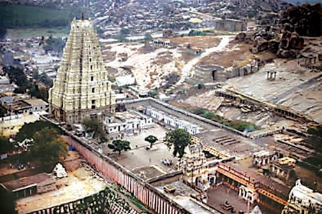
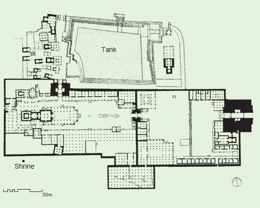
- Long development: Inscriptions indicate that the earliest shrine dated to the ninth–tenth centuries; the complex was greatly enlarged after the Vijayanagara Empire was established.
- Krishnadeva Raya’s building: He commissioned the hall before the main shrine to mark his accession and is also credited with building the eastern gopuram.
- Changing scale: The additions made the central shrine a relatively small part of the expanded complex.
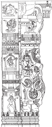
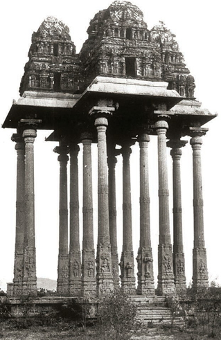
- Ritual and performance: Halls hosted special programmes of music, dance and drama, with images of gods placed there to witness them.
- Deity festivals: Other halls were used for divine weddings or for swinging deity images. Special images were used for these events, separate from those in the small central shrine.
The Vitthala Temple and Temple Streets
A temple drawing on different traditions
- Principal deity: Vitthala was a form of Vishnu generally worshipped in Maharashtra.
- Imperial culture: Introducing Vitthala worship in Karnataka shows how Vijayanagara rulers drew on diverse traditions to shape an imperial culture.
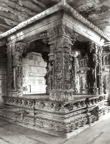
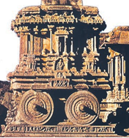
- Distinctive shrine: The temple contained several halls and a unique shrine designed as a chariot.
- Chariot streets: Straight streets extended from temple gopurams; they were paved with stone slabs and lined with pillared pavilions.
- Trade: Merchants used the pillared pavilions as shops, connecting temple activity with urban commerce.
Nayakas and temple building
- Continuation and elaboration: Nayakas carried forward and expanded earlier traditions of temple building, just as they did with fortification.
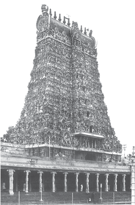
- Local patronage: Some of the most impressive gopurams were built by local nayakas, including those at Madurai.
How Vijayanagara Adapted Earlier Ritual Architecture
- Earlier regional temple traditions and sacred sites provided an established religious foundation.
- Vijayanagara rulers patronised temples and linked their kingship to Virupaksha.
- They enlarged temple complexes with monumental raya gopurams, mandapas, corridors and royal imagery.
- New and expanded halls supported performances, deity weddings and other rituals.
- Nayakas continued the tradition, while temple streets and shops tied religious centres to urban life.
- Raya gopuram
- A monumental royal gateway to a temple, often towering above the shrine’s own tower.
- Mandapa
- A pavilion or hall, often pillared, used for temple ceremonies and events.
- Kalyana mandapa
- A hall used to celebrate the marriage of deities.
- Hindu Suratrana
- A Vijayanagara royal title meaning “Hindu Sultan”.
- Nayaka
- A local military-political leader who also continued and expanded temple building traditions.
How and why did Vijayanagara rulers adopt and adapt earlier traditions of ritual architecture?
Temple Development
- Ninth–tenth centuriesThe earliest shrine at the Virupaksha temple dates to this period, according to inscriptions.
- Vijayanagara EmpireThe Virupaksha temple was substantially enlarged; Krishnadeva Raya added a hall and the eastern gopuram.
Quick recap
- Sacred setting: Vijayanagara’s northern hills held Hindu and Jaina traditions, and local shrines may have shaped the capital’s location.
- Kingship: Rulers claimed to govern for Virupaksha, signed orders in his name and used the title “Hindu Suratrana”.
- Temple role: Temples were religious, social, cultural, economic and learning centres, supported by royal and other grants.
- Architecture: Raya gopurams proclaimed authority; mandapas and corridors supported rituals and temple life.
- Virupaksha: The complex expanded over centuries, with Krishnadeva Raya adding a hall and eastern gateway.
- Vitthala and nayakas: Vitthala worship brought a Maharashtra tradition into Karnataka; nayakas continued temple building and patronage.
Plotting Palaces, Temples and Bazaars
Surveying and Mapping Vijayanagara's Remains
How the site was documented
- Sources: Early surveys by Mackenzie were supplemented by travellers’ accounts and inscriptions.
- Preservation: The Archaeological Survey of India and the Karnataka Department of Archaeology and Museums helped preserve the site.
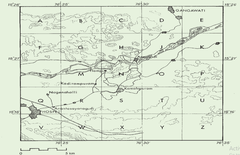
- Mapping project: In the early 1980s, a major project began to document Vijayanagara’s material remains through detailed surveys and varied recording methods.
- Scale of work: Dozens of scholars from around the world worked on the project for nearly twenty years.
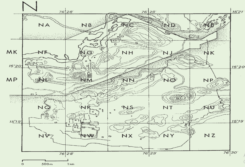
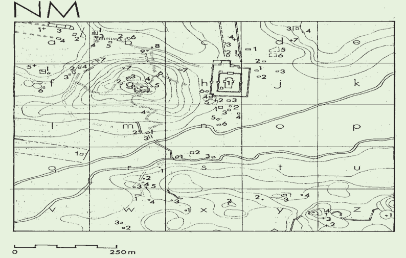
- Grid method: Surveyors divided the area into 25 lettered squares, then subdivided each into progressively smaller units to locate structures precisely.
Documentation of Vijayanagara
- 1976Hampi was recognised as a site of national importance.
- Early 1980sAn extensive project began to document Vijayanagara’s material remains.
- Nearly twenty yearsScholars worked to compile and preserve detailed survey information.
What surveys revealed
- Structures: Surveys documented thousands of remains, from small shrines and residences to elaborate temples.
- Urban features: Traces of roads, paths and bazaars were also identified.
- Markets: Pillar bases and platforms helped locate former market areas, even though the markets themselves had disappeared.
Reading the remains
- Surviving materials: Stone structures remain, but many wooden elements—such as columns, beams, ceilings, eaves and towers—have vanished.
- Reconstruction: Travellers’ descriptions help historians imagine lost features, including plaster and painted decoration.
- Caution: Maps and surviving structures provide evidence, but missing parts cannot always be reconstructed with certainty.
Understanding temple layouts
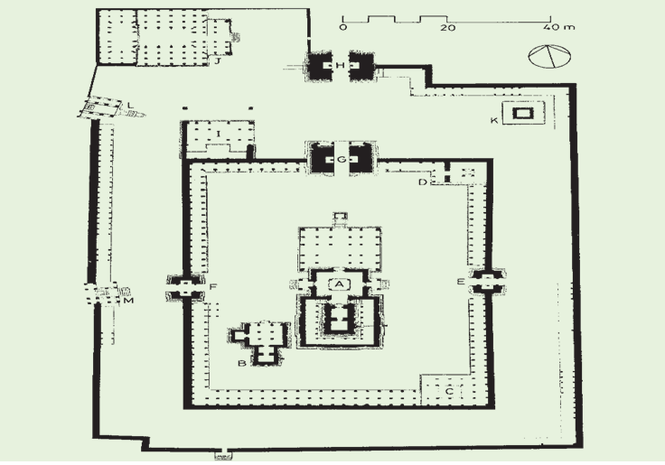
- Main features: Temple plans can show the central shrine, halls, colonnades, enclosing walls and gopurams (gateway towers).
- Route: From an outer entrance, worshippers passed through the gateway and temple spaces, such as halls and colonnades, towards the central shrine.
Markets and the City’s Everyday Life
Travellers’ accounts of the bazaar
- Paes: Described a broad, busy street of merchants selling precious stones, pearls and cloth, alongside an evening fair with horses, fruit, garden produce and wood.
- Provisions: Paes called the city exceptionally well supplied; rice, wheat, grains, barley, beans and pulses were abundant and inexpensive.
- Fernao Nuniz: Reported plentiful, cheap fruits such as grapes, oranges, limes, pomegranates, jackfruit and mangoes.
- Meat: Nuniz also described meat and birds being sold in abundance in the market of Bisnaga, his name for Vijayanagara.
What Buildings Can—and Cannot—Tell Us
| Evidence | Interpretation | |
|---|---|---|
| What buildings reveal | Their layout, uses, construction materials and techniques can be studied. | Fortifications, for example, help assess a city’s defence needs and military preparedness. |
| Ideas and influence | Architectural features can be compared with buildings elsewhere. | Comparisons can indicate cultural influences and ideas that builders or patrons wished to express. |
| Symbols | Buildings may contain symbols shaped by their cultural context. | Understanding them requires other sources, including literature, inscriptions and popular traditions. |
Limits of architectural evidence
- Ordinary people: Buildings alone do not reveal what most residents—men, women and children—thought about grand architecture.
- Access and response: We cannot tell from structures alone whether ordinary people entered the royal or sacred centres, or how they understood their sculpture.
- Workers’ experience: The thoughts and experiences of people who laboured on major construction projects remain difficult to recover.
Royal Image and the Builders
Krishnadeva Raya: Two Perspectives
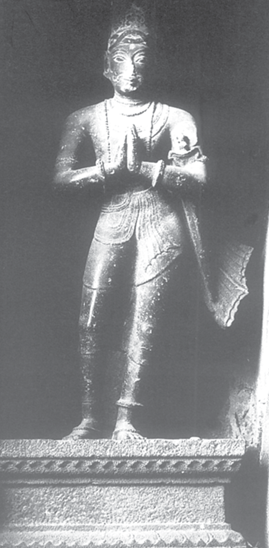
- Royal image: A statue of Krishnadeva Raya on a temple gopuram at Chidambaram, Tamil Nadu, shows how the ruler could be publicly represented.
- Paes’s description: The traveller described the king as of medium height, fair complexion and good build, rather fat than thin, with smallpox marks on his face.
- Historical perspective: A royal statue conveys an intended image; a traveller’s account offers a different kind of description.
Questions about construction
- Decisions: Rulers decided what to build, where to build it, which materials to use and what style to follow.
- Unanswered details: Buildings alone do not identify who planned them, where specialists and labourers came from, their wages, who supervised construction or how materials were transported.
- Further evidence: Research using sources beyond the buildings may help answer these questions.
- Material remains
- Surviving physical traces of the past, including buildings and their remains.
- Topographic survey
- Detailed recording of a site's features and terrain.
- Gopuram
- A monumental gateway tower at a temple entrance.
- Bisnaga
- The name Fernao Nuniz used for Vijayanagara.
How did archaeologists document the remains of Vijayanagara?
What can buildings reveal about a city, and what are their limits as historical evidence?
What did Paes and Nuniz report about Vijayanagara’s markets?
Quick recap
- Hampi became a site of national importance in 1976; a major documentation project began in the early 1980s.
- Surveys mapped Vijayanagara in a grid and recorded thousands of structures, roads, paths and market remains.
- Stone survives, while many wooden architectural elements are lost; travellers’ accounts help reconstruct the past.
- Paes and Nuniz described well-stocked, inexpensive markets with diverse goods, food and meat.
- Buildings reveal organisation, defence and cultural ideas, but cannot answer every question about ordinary people or construction workers.
- Krishnadeva Raya’s statue reflects royal representation, while Paes provides a distinct description of the king.
History — ALL CHAPTERS
1
BRICKS, BEADS AND BONES THE HARAPPAN CIVILISATION
2
KINGS, FARMERS AND TOWNS EARLY STATES AND ECONOMIES (C. 600 BCE-600 CE)
3
KINSHIP, CASTE AND CLASS EARLY SOCIETIES (C. 600 BCE-600 CE)
4
THINKERS, BELIEFS AND BUILDINGS CULTURAL DEVELOPMENTS (C. 600 BCE - 600 CE)
1
THROUGH THE EYES OF TRAVELLERS PERCEPTIONS OF SOCIETY (C. TENTH TO SEVENTEENTH CENTURY)
2
BHAKTI- SUFI TRADITIONS CHANGES IN RELIGIOUS BELIEFS AND DEVOTIONAL TEXTS (C. EIGHTH TO EIGHTEENTH CENTURY)
3
AN IMPERIAL CAPITAL VIJAYANAGARA (C. FOURTEENTH TO SIXTEENTH CENTURY)
4
PEASANTS, ZAMINDARS AND THE STATE AGRARIAN SOCIETY AND THE MUGHAL EMPIRE (C. SIXTEENTH- SEVENTEENTH CENTURY)
1
COLONIALISM AND THE COUNTRYSIDE EXPLORING OFFICIAL ARCHIVES
2
REBELS AND THE RAJ THE REVOLT OF 1857 AND ITS REPRESENTATIONS
3
MAHATMA GANDHI AND THE NATIONALIST MOVEMENT CIVIL DISOBEDIENCE AND BEYOND
4
FRAMING THE CONSTITUTION THE BEGINNING OF A NEW ERA