Class 12 Humanities . Geography . India People And Economy . Unit II Human Settlements
Chapter 2: UNIT -II HUMAN SETTLEMENTS
Ch 2
Geography
Class 12 Humanities
Introduction ,ytpes of Rural and Urban Settlement
Meaning and Range of Human Settlements
Human settlement — A cluster of dwellings where people live, together with the territory they use as an economic support base.
Settlement characteristics
- Formation: People group together, build dwellings and other structures, and use a surrounding territory as a resource base.
- Range: Settlements vary from small hamlets to metropolitan cities; their size, spacing, economic activities, social structure, ecology and technology also vary.
- Villages: Usually smaller and more sparsely spaced; they mainly specialise in agriculture and other primary activities.
- Urban settlements: Usually fewer in number but larger, with activities mainly in the secondary and tertiary sectors.
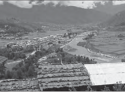
Rural and Urban Settlements
| Point | Rural settlements | Urban settlements |
|---|---|---|
| Economic base | Depend on land-based primary activities, including agriculture. | Depend on processing raw materials, manufacturing finished goods and a range of services. |
| Role and connections | Supply food and raw materials to cities. | Act as economic-growth nodes and provide goods and services to rural settlements in their hinterlands. |
| Social relations | People are generally less mobile, so social relations are intimate. | Life is complex and fast-paced, and social relations are generally formal. |
| Attitudes and outlook | Differ from those in urban areas; rural life is generally less mobile and more closely connected through intimate social relations. | Differ from those in rural areas; urban life is generally fast-paced and complex, with more formal social relations. |
Rural–urban functional relationship
- Villages supply food and raw materials to towns and cities.
- Cities supply goods and services to rural settlements.
- Transport and communication networks enable this exchange.
Types of Rural Settlement
Rural settlement pattern — A settlement pattern is determined mainly by the extent of the built-up area and the distance between houses.
Factors shaping rural settlement patterns in India
- Physical: Terrain, altitude, climate and availability of water.
- Cultural and ethnic: Social structure, caste and religion.
- Security: The need to defend against theft and robbery.
| Type | Main features | Examples of distribution or cause |
|---|---|---|
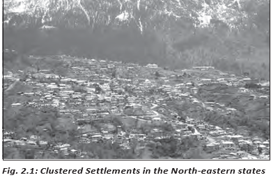
| Clustered, agglomerated or nucleated | Compact, closely built houses; the living area is distinct from surrounding farms, barns and pastures. The layout may be rectangular, radial or linear. | Fertile alluvial plains and northeastern states; also Bundelkhand and Nagaland for security, and Rajasthan where water scarcity encourages compact settlement. |
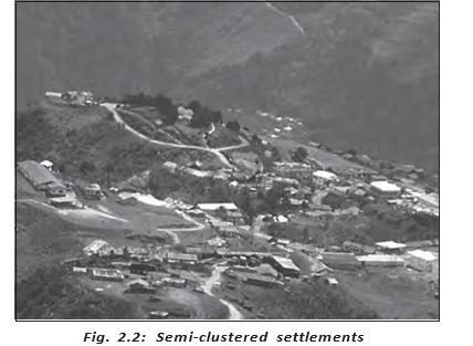
| Semi-clustered or fragmented | A settlement has a main cluster with one or more sections located some distance away; this can follow fragmentation or clustering in a restricted area. | Dominant landowners may occupy the centre while lower-status groups and menial workers live on the outer edges. Common in the Gujarat plain and parts of Rajasthan. |
| Hamleted | A village is split into physically separate units that share a common name; local names include panna, para, palli, nagla and dhani. | Often linked to social and ethnic divisions; common in the middle and lower Ganga plain, Chhattisgarh and lower Himalayan valleys. |
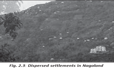
| Dispersed or isolated | Isolated huts or small hamlets lie among farms or pastures, often in remote forests or on hillsides. | Often caused by highly fragmented terrain and habitable land; found in parts of Meghalaya, Uttarakhand, Himachal Pradesh and Kerala. |
Urban Settlements
Characteristics and connections
- Form and size: Urban settlements are generally larger and more compact than rural settlements.
- Functions: They perform varied non-agricultural, economic and administrative functions.
- Connections: Cities link with nearby villages and with one another, directly or through market towns.
- Exchange: Goods and services move between cities and rural areas through these linked settlements.
Urban settlement (Census of India, 1991 definition) — A place with a municipality, corporation, cantonment board or notified town area committee; at least 5,000 people; at least 75% of male workers in non-agricultural pursuits; and a population density of at least 400 persons per square kilometre.
What factors determine rural settlement patterns in India?
State the four broad types of rural settlement.
What criteria define an urban settlement in the 1991 Census definition?
Quick recap
- A human settlement is a group of dwellings and the territory that supports its inhabitants.
- Rural settlements mainly depend on primary activities; urban settlements focus on manufacturing, services and administration.
- Rural and urban settlements differ in economic base, social relations, attitudes and outlook.
- Urban and rural places exchange goods and services through transport and communication networks.
- Rural settlement patterns are shaped by physical, cultural, ethnic and security factors; the four types are clustered, semi-clustered, hamleted and dispersed.
- The 1991 Census definition uses local-body status, population, male-worker occupation and population-density criteria.
Evolution of Towns in India
Towns by Historical Evolution
Historical classification — Indian towns are grouped by the period of their development as ancient, medieval or modern towns.
Broad Stages of Town Development
- Prehistoric times and the Indus Valley CivilisationTowns existed in India; Harappa and Mohenjodaro are early examples.
- Ancient and medieval periodsTowns developed through successive periods, with periodic ups and downs.
- Eighteenth centuryEuropean arrival marked a new phase in the development of Indian towns.
- After 1850Towns based on modern industries began to develop.
- After independenceNew administrative and industrial towns, satellite towns, and medium and small towns developed.
| Type | Main features | Examples |
|---|---|---|
| Ancient | Many have a history spanning over 2,000 years; most developed as religious and cultural centres. | Varanasi, Prayag (Allahabad), Pataliputra (Patna), Madurai |
| Medieval | About 100 existing towns have medieval roots; many were kingdom or principality headquarters and fort towns built on ancient-town ruins. | Delhi, Hyderabad, Jaipur, Lucknow, Agra, Nagpur |
| Modern | Developed through European influence, modern industries, colonial administration and post-independence planning. | Mumbai, Chennai, Kolkata, Jamshedpur, Chandigarh |
Development of Modern Towns
European and British Urban Development
- Coastal footholds: Europeans first developed trading ports, including Surat, Daman, Goa and Pondicherry.
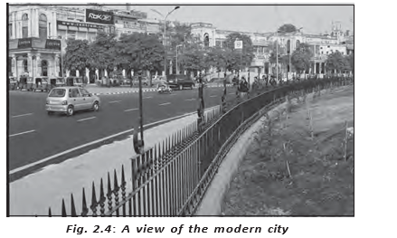
- British centres: The British consolidated power around Mumbai (Bombay), Chennai (Madras) and Kolkata (Calcutta), developing them in the British style.
- Colonial expansion: British rule established administrative centres, hill towns as summer resorts, and new civil, administrative and military areas.
- Industrial towns: Modern industrial towns emerged after 1850; Jamshedpur is an example.
Town Growth after Independence
- Administrative centres: Chandigarh, Bhubaneswar, Gandhinagar and Dispur developed as administrative headquarters.
- Industrial centres: Durgapur, Bhilai, Sindri and Barauni developed as industrial towns.
- Satellite towns: Ghaziabad, Rohtak and Gurugram grew around Delhi.
- Further growth: Investment in rural areas also encouraged medium and small towns to develop across the country.
Urbanisation in India
Level of urbanisation — The percentage of the total population living in urban areas.
is the urban population and is the total population.
Key Trends
- 2011 level: India was 31.16 percent urbanised, which was low compared with developed countries.
- Twentieth-century growth: India's total urban population increased eleven-fold.
- Main contributors: Enlargement of existing urban centres and the emergence of new towns increased urban population and urbanisation.
- Recent pace: The growth rate of urbanisation slowed during the last two decades covered in the text.
| Year | Towns/UAs | Urban population (thousands) | Share of total population | Decennial growth |
|---|---|---|---|---|
| 1901 | 1,827 | 25,851.9 | 10.84 percent | — |
| 1911 | 1,815 | 25,941.6 | 10.29 percent | 0.35 percent |
| 1921 | 1,949 | 28,086.2 | 11.18 percent | 8.27 percent |
| 1931 | 2,072 | 33,456.0 | 11.99 percent | 19.12 percent |
| 1941 | 2,250 | 44,153.3 | 13.86 percent | 31.97 percent |
| 1951 | 2,843 | 62,443.7 | 17.29 percent | 41.42 percent |
| 1961 | 2,365 | 78,936.6 | 17.97 percent | 26.41 percent |
| 1971 | 2,590 | 1,09,114 | 19.91 percent | 38.23 percent |
| 1981 | 3,378 | 1,59,463 | 23.34 percent | 46.14 percent |
| 1991 | 4,689 | 2,17,611 | 25.71 percent | 36.47 percent |
| 2001 | 5,161 | 2,85,355 | 27.78 percent | 31.13 percent |
| 2011 | 6,171 | 3,77,000 | 31.16 percent | 31.08 percent |
Functional Classification of Towns
Functional classification — Towns may be grouped by their dominant or specialised function, while also serving as central or nodal places and performing several functions.
| Type | Dominant function | Examples |
|---|---|---|
| Administrative | Hosts higher-order administrative headquarters. | Chandigarh, New Delhi, Bhopal, Shillong, Guwahati, Imphal, Srinagar, Gandhinagar, Jaipur, Chennai |
| Industrial | Industry is the main driving activity. | Mumbai, Salem, Coimbatore, Modinagar, Jamshedpur, Hugli, Bhilai |
| Transport | Ports handle exports and imports; other towns act as inland transport hubs. | Ports: Kandla, Kochchi, Kozhikode, Vishakhapatnam; inland hubs: Agra, Dhulia, Mughalsarai, Itarsi, Katni |
| Commercial | Specialises in trade and commerce. | Kolkata, Saharanpur, Satna |
| Mining | Developed in mineral-rich areas. | Raniganj, Jharia, Digboi, Ankaleshwar, Singrauli |
| Garrison or cantonment | Developed as military garrison towns. | Ambala, Jalandhar, Mhow, Babina, Udhampur |
| Educational | Grew from centres of education into major campus towns. | Roorkee, Varanasi, Aligarh, Pilani, Allahabad |
| Religious and cultural | Prominent because of religious or cultural significance. | Varanasi, Mathura, Amritsar, Madurai, Puri, Ajmer, Pushkar, Tirupati, Kurukshetra, Haridwar, Ujjain |
| Tourist | Attracts visitors as a tourist destination. | Nainital, Mussoorie, Shimla, Pachmarhi, Jodhpur, Jaisalmer, Udagamandalam (Ooty), Mount Abu |
Smart Cities Mission
- Objective: Promote cities with core infrastructure, a clean and sustainable environment, and a decent quality of life.
- Smart solutions: Improve infrastructure and services, reduce disaster vulnerability, use fewer resources and provide cheaper services.
- Development approach: Focus on sustainable and inclusive development in compact areas; create replicable models for other aspiring cities.
Changing Urban Functions
- Dynamic functions: A town's functions can change as it grows.
- Multifunctional cities: Specialised towns may develop into metropolises where industry, business, administration and transport all become important.
- Classification limit: As functions become intertwined, a city may no longer fit into a single functional class.
What were the main patterns in the development of Indian towns after independence?
Why can a large city be difficult to place in one functional class?
Quick recap
- Indian towns existed from prehistoric times and are historically classified as ancient, medieval or modern.
- European ports and British colonial centres developed alongside administrative, military, hill and industrial towns.
- After independence, administrative and industrial centres, satellite towns, and medium and small towns expanded.
- India was 31.16 percent urbanised in 2011; its urban population grew eleven-fold during the twentieth century.
- Functional classes include administrative, industrial, transport, commercial, mining, garrison, educational, religious-cultural and tourist towns.
- Cities can change function and become multifunctional; the Smart Cities Mission promotes inclusive, sustainable development and better urban services.
Geography — ALL CHAPTERS
1
Human Geography Nature And Scope
2
The World Population Distribution, Density And Growth
3
Human Development
4
Primary Activities
5
Secondary Activities
6
Tertiary And Quaternary Activities
7
Transport And Communication
8
International Trade
1
UNIT -I POPULATION DISTRIBUTION ,DENSITY, GROWTH AND COMPOSITION
2
UNIT -II HUMAN SETTLEMENTS
3
UNIT- III LAND RESOURCES AND AGRICULTURE
4
UNIT -III WATER RESOURCES
5
UNIT - III MINERAL AND ENERGY RESOURCES
6
UNIT -III PLANNING AND SUSTAINABLE DEVELOPMENT IN INDIAN CONTEXT
7
UNIT -IV TRANSPORT AND COMMUNICATION
8
UNIT -IV INTERNATIONAL TRADE
9
UNIT - V GEOGRAPHICAL PERSPECTIVE ON SELECTED ISSUES AND PROBLEMS