Class 12 Humanities . Geography . India People And Economy . Unit III Land Resources and Agriculture
Chapter 3: UNIT- III LAND RESOURCES AND AGRICULTURE
Ch 3
Geography
Class 12 Humanities
Land Use Categories
Land use — The way people use land for production, residence and recreation.
Land-Use Records and Area
How Land Area Is Recorded
- Land-use records: Maintained by the Land Revenue Department; the categories together make up the reporting area.
- Geographical area: Measured by the Survey of India for administrative units and remains fixed according to its measurements.
- Reporting area: May vary somewhat as estimates in land revenue records change.
| Point | Reporting area | Geographical area |
|---|---|---|
| Recorded or measured by | Land Revenue Department records | Survey of India |
| Nature | Sum of land-use categories | Area of administrative units |
| Change over time | Can vary with land-record estimates | Fixed according to Survey of India measurements |
Land-Use Categories in Land Revenue Records
| Category | Meaning and key points |
|---|---|
| Forests | Area identified and demarcated by the Government for forest growth. This recorded area differs from actual forest cover; it can increase without an increase in actual forest cover. |
| Barren and wastelands | Land generally not cultivable with available technology, such as barren hills, deserts and ravines. |
| Land put to non-agricultural uses | Settlements (rural and urban), infrastructure such as roads and canals, industries and shops. Expansion of secondary and tertiary activities increases this land-use category. |
| Permanent pastures and grazing lands | Mostly owned by village Panchayats or the Government; only a small share is privately owned. Panchayat-owned land is a Common Property Resource. |
| Miscellaneous tree crops and groves | Includes orchards and fruit trees; excluded from net sown area. Much of this land is privately owned. |
| Culturable wasteland | Land left uncultivated for more than five years. It can be cultivated after improvement through reclamation. |
| Current fallow | Land left uncultivated for one agricultural year or less. Fallowing gives land a rest and allows natural processes to restore lost fertility. |
| Fallow other than current fallow | Cultivable land left uncultivated for more than one year but less than five years. After more than five years, it is classified as culturable wasteland. |
| Net area sown | Physical extent of land on which crops are sown and harvested. |
| Category | Time left uncultivated | Key point |
|---|---|---|
| Current fallow | One agricultural year or less | Allows the land to rest and regain fertility naturally. |
| Fallow other than current fallow | More than one year but less than five years | Still classified as cultivable land. |
| Culturable wasteland | More than five years | May be brought under cultivation after reclamation. |
How are current fallow, other fallow and culturable wasteland distinguished?
Why can recorded forest area increase without an increase in actual forest cover?
Quick recap
- Land is used for production, residence and recreation.
- Land-use records are maintained by the Land Revenue Department; the Survey of India measures geographical area.
- Reporting area may vary, while geographical area is fixed according to Survey of India measurements.
- Recorded forest area is the Government-demarcated area, not necessarily actual forest cover.
- Panchayat-owned pastures are Common Property Resources; orchards and fruit groves are excluded from net sown area.
- Fallow categories depend on duration: current fallow is up to one year, other fallow is one to five years, and culturable wasteland is over five years.
- Net area sown is the physical extent on which crops are sown and harvested.
Land-use Changes in India
How Economic Change Affects Land Use
Land use — The way land in a region is used is strongly influenced by its economic activities.
- Fixed resource: Land area is limited, while the size and structure of the economy change over time.
- Economic growth: Population growth, rising incomes and improved technology increase pressure on land, bringing marginal land into use.
- Sectoral shift: Secondary and tertiary sectors generally grow faster than agriculture, shifting land from agricultural to non-agricultural uses—especially near large urban areas.
- Ongoing farm pressure: Agriculture’s share of GDP may fall without a matching fall in the population dependent on it; the growing population also needs to be fed.
Three Economic Changes and Their Land Effects
- Economic size grows with population, income and technology → pressure on fixed land area rises → marginal lands are brought into use.
- Secondary and tertiary sectors expand faster than agriculture → land shifts to non-agricultural uses, particularly around large cities.
- Agriculture’s GDP contribution declines, but its dependent population falls more slowly and food demand grows → pressure on agricultural land continues.
Patterns of Land-Use Change
Periods Compared
- 1950–51 to 2014–15Land-use changes are discussed using percentages of India’s reporting area.
- 1950–51 and 2019–20The figure compares the land-use categories for these two years.
How to Read the Land-Use Data
- Basis: Percentages are calculated relative to the reporting area, which remained relatively constant over time.
- Connection: A decline in one land-use category usually corresponds to an increase in another category.
- Overall pattern: The text reports increases in five categories and declines in four; it specifically discusses four increasing categories.
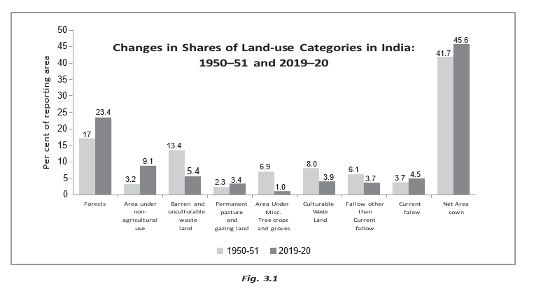
| Category | Trend and explanation |
|---|---|
| Area under non-agricultural uses | Highest rate of increase; driven by growth of industry and services, infrastructure, and urban and rural settlements. It expands at the expense of wasteland and agricultural land. |
| Area under forest | The increase reflects more land being demarcated as forest, not necessarily an actual increase in forest cover. |
| Current fallow land | It varies greatly with rainfall and cropping cycles, so two time points alone cannot explain its trend. |
| Net area sown | Its recent increase resulted from bringing culturable wasteland into agriculture. Earlier it declined slowly, largely as land shifted to non-agricultural uses. |
| Category | Main explanation |
|---|---|
| Barren and wasteland | Declined as pressure from agricultural and non-agricultural uses increased. |
| Culturable wasteland | Declined as pressure from agricultural and non-agricultural uses increased; some was brought into cultivation. |
| Area under tree crops and groves | Declined mainly because of pressure to expand agricultural land. |
| Fallow lands | Registered a decline; the text gives no separate explanation for this category. |
Actual Increase and Rate of Increase
| Point | Actual increase | Rate of increase |
|---|---|---|
| Meaning | The change in the land-use value between two years. | The change expressed relative to the base-year value. |
| Calculation | Terminal-year value minus base-year value. | Difference divided by base-year value, then multiplied by 100 for a percentage. |
| Result | Same units as the original land-use data. | A percentage, allowing comparison across categories of different sizes. |
Use the terminal year value and subtract the base year value.
For a percentage rate, divide the difference by the base-year value and multiply by 100.
For the 1950–51 to 2014–15 comparison, use 1950–51 as the base year. The numerical data needed for category-wise calculations are not provided in this lecture text.
Why can pressure on agricultural land remain high even when agriculture’s contribution to GDP declines?
Why does an increase in area demarcated as forest not necessarily mean that forest cover has increased?
Quick recap
- Land area is fixed, but economic growth increases competition for it and can bring marginal lands into use.
- Faster growth of industry and services shifts land from agriculture to non-agricultural uses, especially near urban areas.
- Agricultural land remains under pressure because food needs rise and agricultural dependence declines slowly.
- Non-agricultural uses had the highest increase rate; forest, current fallow and net area sown also increased in the discussion.
- Wastelands, culturable wastelands, tree crops and groves, and fallow lands registered declines.
- Actual increase is a difference; rate of increase compares that difference with the base-year value.
Common Property Resources and Cropping Season
Common Property Resources (CPRs)
| Point | Private land | Common property resources |
|---|---|---|
| Ownership | Owned by an individual or a group of individuals. | State-owned for community use. |
| Rights | Property rights belong to the owner(s). | Community members have access and use rights, with specified obligations; no individual holds property rights. |
Common Property Resource (CPR) — A community natural resource that members may access and use under shared obligations, without individual property rights.
Uses and importance
- Examples: Community forests, pasture lands, village water bodies and public spaces used and managed by groups larger than a household.
- Resources: CPRs supply livestock fodder, household fuel and minor forest products such as fruits, nuts, fibre and medicinal plants.
- Livelihoods: They are especially important to landless and marginal farmers and other weaker sections, many of whom rely on livestock income.
- Women’s work: Rural women often collect fuel and fodder; degraded CPR land can make this work especially time-consuming.
Agricultural Land Use in India
Why land matters in agriculture
- Land-based activity: Agriculture depends directly on land, unlike secondary and tertiary activities; land contributes more directly to agricultural output.
- Poverty link: Limited access to land is closely associated with rural poverty.
- Land quality: The quality of land directly affects agricultural productivity.
- Social and security value: In rural areas, land ownership can provide credit security, protection against natural hazards and life contingencies, and social status.
Total cultivable land — The total stock of agricultural land resources, calculated by adding net area sown, all fallow lands and culturable wasteland.
| Agricultural land-use category | Of reporting area, 1950–51 | Of reporting area, 2019–20 | Of total cultivable land, 1950–51 | Of total cultivable land, 2019–20 |
|---|---|---|---|---|
| Culturable wasteland | ||||
| Fallow land other than current fallow | ||||
| Current fallow | ||||
| Net area sown | ||||
| Total cultivable land |
Land-saving technologies and cropping intensity
- Land availability: The total cultivable land stock declined slightly as a share of reporting area between 1950–51 and 2019–20; scope to add more land to the net sown area is limited.
- Need: India must adopt land-saving technologies to raise agricultural output from limited land.
- Yield-raising technology: Increases the yield of a particular crop per unit area.
- Land-use-intensity technology: Raises total annual output per unit area by growing more crops on the land.
- Why intensity matters: It makes fuller use of scarce land and increases labour demand, helping reduce rural unemployment in a land-scarce, labour-abundant country.
is gross cropped area and is net sown area.
Cropping Seasons in India
| Season | Period | Northern states: major crops | Southern states: major crops |
|---|---|---|---|
| Kharif | June–September; largely coincides with the south-west monsoon. | Rice, cotton, bajra, maize, jowar, tur | Rice, maize, ragi, jowar, groundnut |
| Rabi | October–March in the table; begins with winter in October–November and ends in March–April. | Wheat, gram, rapeseeds and mustard, barley | Rice, maize, ragi, groundnut, jowar |
| Zaid | April–June; short summer season after rabi harvest. | Vegetables, fruits, fodder | Rice, vegetables, fodder |
Seasonal conditions
- Kharif: Monsoon conditions support tropical crops such as rice, cotton, jute, jowar, bajra and tur.
- Rabi: Low winter temperatures favour temperate and subtropical crops such as wheat, gram and mustard.
- Zaid: Watermelons, cucumbers, vegetables and fodder crops are grown on irrigated land during this short summer season.
- Southern India: The same seasonal distinction is less marked because temperatures allow tropical crops to grow through the year if soil moisture is available; the same crop may be grown three times in one agricultural year when moisture is sufficient.
- Net area sown (NSA)
- Land sown with crops at least once in the agricultural year.
- Gross cropped area (GCA)
- The total area sown, counting areas cropped more than once in the same year each time.
- Cropping intensity
- The percentage relationship between gross cropped area and net sown area.
- Culturable wasteland
- Land that can be cultivated but is not currently being used for cultivation.
Why is high cropping intensity desirable in India?
How do cropping seasons differ between northern and southern India?
Quick recap
- CPRs are community resources used and managed under shared rights and obligations; they support rural livelihoods.
- Agricultural land affects productivity, poverty, rural security and social status.
- Total cultivable land includes net area sown, all fallow lands and culturable wasteland.
- Land-saving technology raises yield per crop or increases annual output by intensifying land use.
- Cropping intensity is calculated as .
- Kharif, rabi and zaid are the three main cropping seasons; southern India’s seasons are less distinct when soil moisture is available.
Type of Farming
Farming by Source of Moisture
Irrigated farming — Farming in which irrigation supplies water to crops, either as a supplement to rainfall or to ensure adequate moisture for high yields.
| Point | Protective irrigation | Productive irrigation |
|---|---|---|
| Aim | Protect crops from harmful soil-moisture deficiency; irrigation supplements rainfall. | Provide sufficient moisture through the cropping season to achieve high productivity. |
| Water per unit area | Lower input. | Higher input than protective irrigation. |
| Coverage or result | Spread available moisture over the maximum possible area. | Support high crop productivity. |
Rainfed farming (barani) — Farming that depends mainly on rainfall rather than irrigation.
| Type | Moisture conditions | Crops and practices | Main concerns |
|---|---|---|---|
| Dryland farming | Soil moisture is limited; in India, mainly regions receiving less than annual rainfall. | Hardy, drought-resistant crops such as ragi, bajra, moong, gram and guar (fodder); soil-moisture conservation and rainwater harvesting. | Frequent moisture stress. |
| Wetland farming | Rainfall exceeds plants’ soil-moisture requirements during the rainy season. | Water-intensive crops such as rice, jute and sugarcane; aquaculture in freshwater bodies. | Flooding and soil erosion hazards. |
Foodgrains and Cereals
Importance and Classification
- Importance: Foodgrains occupy about two-thirds of India’s total cropped area and are important in both subsistence and commercial farming.
- Classification: By grain structure, foodgrains are divided into cereals and pulses.
- Cereals: Cover about of the total cropped area; India produces about of the world’s cereals and ranks third after China and the U.S.A.
- Cereal types: Fine grains include rice and wheat; coarse grains include jowar, bajra, maize and ragi.
Rice
Rice: Conditions, Seasons and Distribution
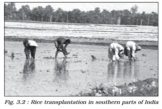
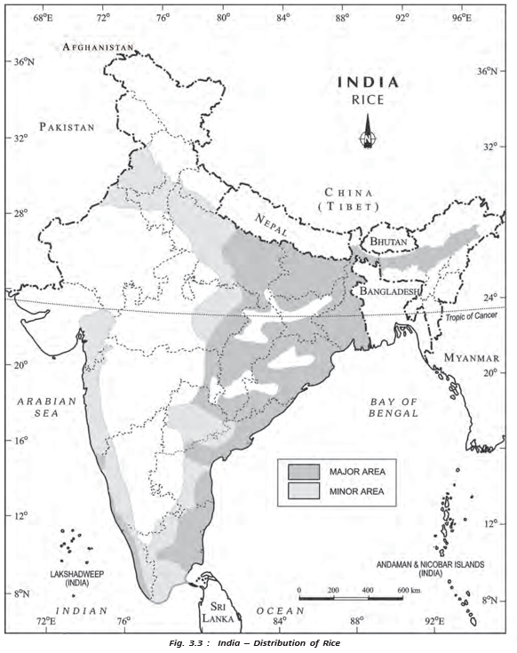
- Importance: Rice is the staple food of the overwhelming majority of India’s population and covers about one-fourth of the country’s cropped area.
- Adaptability: Though associated with humid tropical areas, rice grows across varied climates—from sea level to about altitude, and in both humid eastern India and dry, irrigated areas in the northwest.
- Multiple crops: Southern states and West Bengal can grow two or three rice crops in a year; West Bengal’s crops are aus, aman and boro.
- Season: In the Himalayas and northwestern India, rice is mainly a kharif crop grown during the southwest monsoon.
- Leading producers: West Bengal, Uttar Pradesh and Punjab are the leading rice-producing states.
- World position: India produced of the world’s rice and ranked second after China in 2018.
Rice: Yields and Regional Differences
- High yields: Punjab, Tamil Nadu, Haryana, Andhra Pradesh, Telangana, West Bengal and Kerala have high rice yields.
- Irrigation: Almost all rice land in Punjab, Haryana, Tamil Nadu and Andhra Pradesh is irrigated.
- New rice regions: Punjab and Haryana were not traditional rice-growing areas; irrigation brought rice cultivation there in the 1970s after the Green Revolution.
- Reasons for high yields in Punjab and Haryana: Improved seed varieties, relatively heavy fertiliser and pesticide use, and lower pest susceptibility in the dry climate.
- Low yields: Rainfed rice-growing areas of Madhya Pradesh, Chhattisgarh and Odisha have low yields.
Wheat
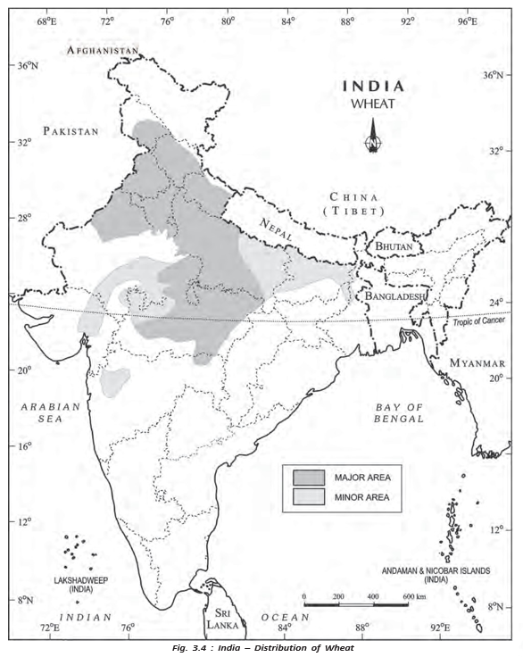
Wheat: Conditions and Distribution
- Importance: Wheat is India’s second most important cereal after rice; it accounted for about of world wheat production in 2017.
- Season: A temperate-zone crop grown in India during winter, in the rabi season.
- Concentration: About of wheat area is in northern and central India—especially the Indo-Gangetic Plain, Malwa Plateau and Himalayas up to about altitude.
- Water source: Mostly irrigated because it is a rabi crop; rainfed in Himalayan highlands and parts of the Malwa Plateau in Madhya Pradesh.
- Area and leading states: Covers about of India’s cropped area. Uttar Pradesh, Madhya Pradesh, Punjab, Haryana and Rajasthan are leading producers.
Wheat: Yield Differences
- Very high yields: Punjab and Haryana produce more than .
- Moderate yields: Uttar Pradesh, Rajasthan and Bihar.
- Low yields: Rainfed wheat in Madhya Pradesh, Himachal Pradesh and Jammu and Kashmir.
Coarse Cereals
Jowar (Sorghum)
- Area and role: Coarse cereals together cover about of cropped area; jowar alone covers about . It is a main food crop in semi-arid central and southern India.
- Leading producer: Maharashtra produces more than half of India’s jowar; other producers are Karnataka, Madhya Pradesh, Andhra Pradesh and Telangana.
- Seasons and use: Grown in both kharif and rabi seasons in southern states; in northern India it is a kharif crop, mostly used as fodder.
- Yield: South of the Vindhyachal, jowar is rainfed and yields are very low.
Bajra
- Conditions: Grown in hot, dry northwestern and western India; it tolerates frequent dry spells and drought.
- Cropping pattern and area: Cultivated alone or in mixed cropping; occupies about of total cropped area.
- Leading producers: Rajasthan, Maharashtra, Gujarat, Uttar Pradesh and Haryana.
- Yield improvement: Drought-resistant varieties and expanded irrigation have raised yields in Rajasthan, Haryana and Gujarat in recent years.
Maize
- Use and conditions: Both a food and fodder crop; grown in semi-arid climates and on inferior soils.
- Area and spread: Covers about of cropped area and is grown across India, except Punjab and the eastern and northeastern regions.
- Leading producers: Karnataka, Madhya Pradesh, Bihar, Andhra Pradesh, Telangana, Rajasthan and Uttar Pradesh.
- Yield: Higher than other coarse cereals; highest in southern states and declines towards central India.
Pulses
Importance and Distribution of Pulses
- Food value: Pulses are an important part of vegetarian diets because they are rich in protein.
- Soil fertility: As legumes, pulses improve natural soil fertility through nitrogen fixation.
- Area and location: They occupy about of India’s total cropped area and are concentrated in the drylands of the Deccan and central plateaus and the northwest.
- Production: India is a leading pulse producer globally, but rainfed dryland cultivation leads to low and year-to-year variable yields.
- Main crops: Gram and tur are the principal pulses cultivated in India.
Gram
Gram: Cultivation and Distribution
- Conditions and season: A subtropical crop, mostly rainfed and grown in the rabi season across central, western and northwestern India.
- Water need: Usually requires only one or two light showers or irrigations for successful growth.
- Cropping change: After the Green Revolution, wheat displaced gram from cropping patterns in Haryana, Punjab and northern Rajasthan.
- Area and producers: Covers about of cropped area; main producers are Madhya Pradesh, Uttar Pradesh, Maharashtra, Andhra Pradesh, Telangana and Rajasthan.
- Yield: Generally low and variable from year to year, even in irrigated areas.
Tur (Arhar)
Tur: Cultivation and Distribution
- Other names: Red gram or pigeon pea; India’s second most important pulse crop.
- Conditions: Grown on marginal land under rainfed conditions in dry areas of central and southern India.
- Area and production: Occupies about of India’s cropped area. Maharashtra produces about one-third of the total.
- Other leading producers: Uttar Pradesh, Karnataka, Gujarat and Madhya Pradesh.
- Yield: Per-hectare output is very low and inconsistent.
| Point | Cereals | Pulses |
|---|---|---|
| Main role | Major foodgrains; include fine and coarse grains. | Protein-rich food, especially important in vegetarian diets. |
| Examples | Rice, wheat, jowar, bajra and maize. | Gram and tur. |
| Land or soil effect | Crop conditions and water needs vary by cereal. | Legumes fix nitrogen and improve natural soil fertility. |
| India’s cropped area | About . | About . |
- Barani farming
- Rainfed farming that depends mainly on rainfall.
- Kharif
- Crop season associated with the southwest monsoon.
- Rabi
- Winter cropping season; wheat and gram are grown in this season.
- Nitrogen fixation
- Process through which legume crops add nitrogen to the soil and improve its natural fertility.
Differentiate protective irrigation from productive irrigation.
Why are pulse yields generally low and variable in India?
Name the three rice crops grown in West Bengal and state when rice is mainly grown in northwestern India.
Quick recap
- Farming is irrigated or rainfed; irrigation may be protective or productive.
- Rainfed farming is dryland where moisture is scarce and wetland where rainfall exceeds crop needs.
- Foodgrains cover about two-thirds of India’s cropped area and consist of cereals and pulses.
- Rice is widely adaptable; wheat is mainly a winter, rabi crop concentrated in northern and central India.
- Jowar, bajra and maize are coarse cereals with differing climate needs, locations and yields.
- Pulses provide protein and improve soil fertility through nitrogen fixation, but their rainfed yields are often low and variable.
Oil Seeds and Fiber Crops
Oilseeds
| Crop | Season and conditions | Main regions and key facts |
|---|---|---|
| Groundnut | Mostly a rainfed kharif crop of drylands; also grown in the rabi season in southern India. | Leading producers: Gujarat, Rajasthan, Tamil Nadu, Telangana, Andhra Pradesh, Karnataka, and Maharashtra. Tamil Nadu has comparatively high yields, partly due to irrigation; yields are low in Telangana, Andhra Pradesh, and Karnataka. |
| Rapeseed and mustard | Subtropical rabi crops, sensitive to frost; yields can fluctuate from year to year. | Includes rai, sarson, toria, and taramira. Grown mainly in north-western and central India. Rajasthan produces about one-third of national output; Haryana and Madhya Pradesh are also leading producers. |
| Soybean | An important oilseed crop. | Madhya Pradesh and Maharashtra together produce about 90% of India’s soybean output. |
| Sunflower | An important oilseed crop. | Concentrated in Karnataka, Andhra Pradesh, Telangana, and adjoining Maharashtra. A minor crop in northern India, where irrigation supports high yields. |
Oilseed Production and Yield Patterns
- Groundnut: India produced about 18.8% of world output in 2018; it occupies about 3.6% of India’s cropped area.
- Rapeseed and mustard: Together occupy about 2.5% of cropped area. About two-thirds of their cultivated area is irrigated.
- Yield improvement: Irrigation expansion and improved seed technology have helped raise and stabilise rapeseed and mustard yields.
- High yields: Rapeseed and mustard yields are comparatively high in Haryana and Rajasthan.
Fibre Crops
- Purpose: Fibre crops provide raw material for cloth, bags, sacks and other products.
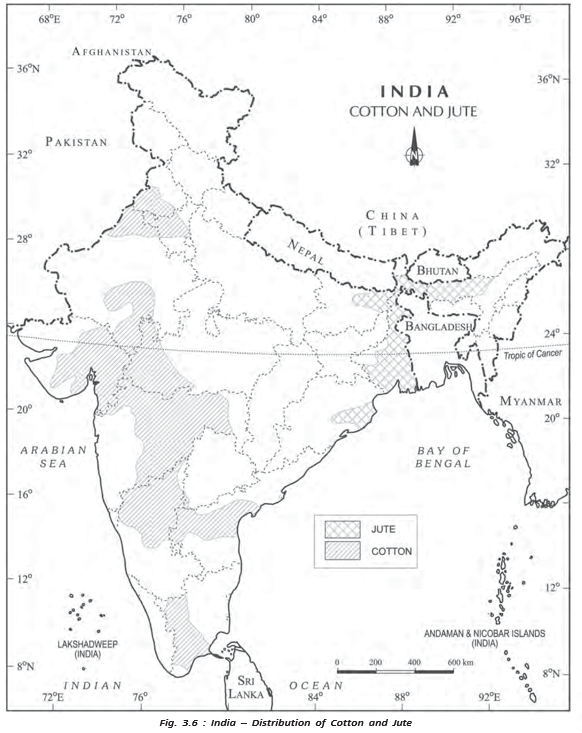
- Main crops: Cotton and jute are the two principal fibre crops grown in India.
Cotton
Jute
- Uses: Jute is used to make coarse cloth, bags, sacks and decorative items.
- Distribution: West Bengal is the chief producer; Bihar and Assam are also important growing areas.
- Production: India produces about three-fifths of the world’s jute. The crop occupies about 0.5% of India’s cropped area.
Other Important Crops
- Crop group: This section moves from fibre crops to other economically important crops, including plantation and beverage crops.
Sugarcane
Tea
Tea Cultivation in India
- 1840sTea plantation began in India’s Brahmaputra Valley in Assam.
Coffee
- Oilseed
- A crop grown mainly to extract oil.
- Fibre crop
- A crop grown to provide fibre for textiles and other products.
- Plantation crop
- A commercial crop cultivated on plantations; tea and coffee are examples.
- Rainfed crop
- A crop grown mainly using rainfall rather than irrigation.
Name India’s main oilseed crops and state where soybean is concentrated.
Describe cotton’s main growing regions and yield pattern in India.
State India’s world position in sugarcane, tea, and coffee in 2018.
Quick recap
- Oilseeds cover about 14% of India’s cropped area; the main crops are groundnut, rapeseed and mustard, soybean, and sunflower.
- Groundnut is mainly rainfed; rapeseed and mustard yields have benefited from irrigation and improved seed technology.
- Cotton is a kharif crop of semi-arid regions; Gujarat, Maharashtra, and Telangana are leading producers.
- Jute is concentrated in eastern India, especially West Bengal, which produces about three-fourths of India’s crop.
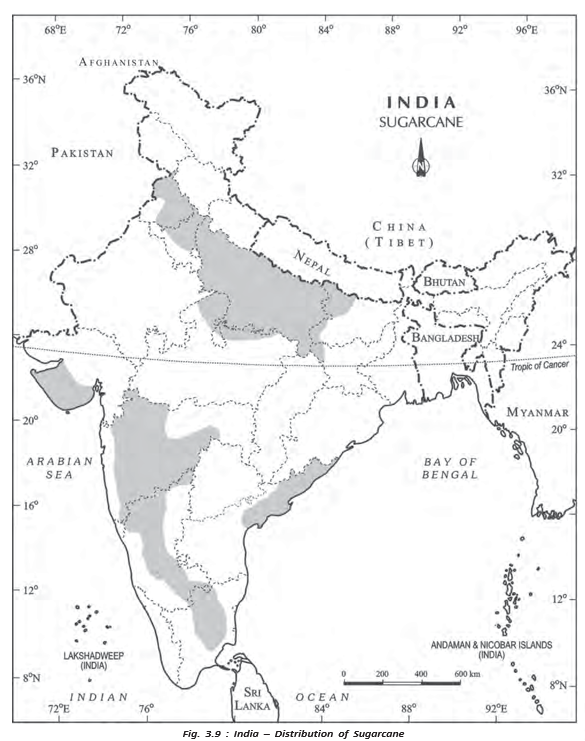
- Sugarcane is largely irrigated; Uttar Pradesh leads production, while several western and southern states have high yields.
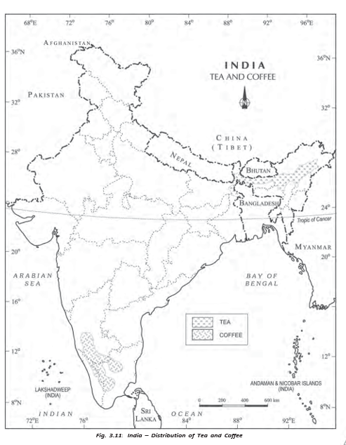
- Tea is concentrated in Assam, West Bengal, and Tamil Nadu; coffee is grown mainly in Western Ghats highlands, especially Karnataka.
Agricultural Development in India
Agriculture Before and After Independence
Starting conditions and early measures
- Before Independence: Agriculture was largely subsistence-based and performed poorly in the first half of the twentieth century; droughts and famines were severe.
- Partition: About one-third of undivided India’s irrigated land went to Pakistan, reducing the share of irrigated land in independent India.
- Immediate post-Independence aims: Shift some land from cash crops to food crops, intensify cropping on existing farmland, and bring cultivable and fallow land under cultivation.
- Initial result: Foodgrain output rose at first, but agricultural production stagnated in the late 1950s.
- Response: The Intensive Agricultural District Programme (IADP) and Intensive Agricultural Area Programme (IAAP) were launched to address stagnation.
Food crisis in the mid-1960s
- Two consecutive droughts
- Foodgrain shortages and a national food crisis
- India imported foodgrains from other countries
Green Revolution
Green Revolution — A rapid rise in foodgrain production resulting from the use of high-yielding varieties (HYVs) and modern agricultural inputs.
Technology, requirements and effects
- HYV seeds: New wheat varieties came from Mexico and rice varieties from the Philippines; they became available by the mid-1960s.
- Package technology: HYV seeds were introduced with chemical fertilisers, initially in irrigated areas of Punjab, Haryana, western Uttar Pradesh, Andhra Pradesh and Gujarat.
- Essential condition: Reliable irrigation was necessary to provide assured soil moisture for the technology to succeed.
- Benefits: Foodgrain production rose rapidly, making India self-reliant in foodgrain production; growth also stimulated agro-input, agro-processing and small-scale industries.
- Uneven spread: Initially limited to irrigated areas, the Green Revolution increased regional disparities. After the 1970s, the technology spread to eastern and central India.
Green Revolution: inputs to outcomes
- HYV seeds + fertilisers + assured irrigation
- Rapid increase in foodgrain production
- Greater national self-reliance in foodgrains
- New regional disparities because adoption was initially concentrated in irrigated regions
Balanced and Sustainable Agricultural Development
Agro-climatic planning and diversification
- 1980s: The Planning Commission focused on problems in rainfed areas.
- Agro-climatic planning: Initiated in 1988 to encourage regionally balanced agricultural development.
- Diversification: Planning also promoted dairy farming, poultry, horticulture, livestock rearing and aquaculture.
National Mission for Sustainable Agriculture (NMSA) — A government mission to make agriculture productive, sustainable, remunerative and climate-resilient while conserving natural resources.
NMSA and organic farming
- Approach: Promote location-specific integrated or composite farming systems.
- Conservation: Use suitable soil- and moisture-conservation measures to protect natural resources.
- Organic farming schemes: Paramparagat Krishi Vikas Yojana (PKVY) and Rashtriya Vikas Yojana (RKVY) promote organic farming.
Liberalisation and agriculture
- 1990s: The adoption of liberalisation and a free-market economy influenced the direction of agricultural development in India.
Growth of Agricultural Output and Technology
Main changes over the last 50 years
- Crop output: Production and yields of rice and wheat rose substantially; sugarcane, oilseeds and cotton production also increased appreciably.
- Irrigation: Expansion of irrigated land helped raise output and enabled the use of modern seeds, fertilisers, pesticides and farm machinery.
- Modern inputs: Adoption of modern agricultural technology spread rapidly across many parts of the country.
- Fertilisers: Chemical fertiliser consumption increased 15-fold since the mid-1960s.
- Pesticides: Their use rose significantly from the 1960s because HYV crops are highly susceptible to pests and diseases.
Role of irrigation in modernising agriculture
- Expansion of irrigation
- More reliable water supply and increased net irrigated area
- Greater scope to use HYV seeds, fertilisers, pesticides and farm machinery
- Higher agricultural output
Farmer’s Portal of India
Information and services
- Purpose: An online platform where farmers can access information related to agriculture.
- Topics: Farmers’ insurance, storage, crops, extension activities, seeds, pesticides and farm machinery.
- Other information: Fertilisers, market prices, package practices, programmes and welfare schemes.
- Interactive map: Provides block-level details on soil fertility, storage, insurance and training.
- Downloads: Farm-friendly handbooks and scheme guidelines are available.
Key periods in agricultural development
- Before IndependenceAgriculture was largely subsistence-based and performed poorly.
- First half of the twentieth centurySevere droughts and famines affected agricultural performance.
- PartitionAbout one-third of undivided India’s irrigated land went to Pakistan.
- Late 1950sAgricultural production stagnated after initial post-Independence gains.
- Mid-1960sTwo consecutive droughts caused a food crisis; HYV-based technology was introduced.
- After the 1970sGreen Revolution technology spread to eastern and central India.
- 1980sThe Planning Commission focused on agricultural problems in rainfed areas.
- 1988Agro-climatic planning began to support regionally balanced development.
- 1990sLiberalisation and the free-market economy influenced agricultural development.
- Subsistence agriculture
- Farming mainly intended to meet the needs of the farmer and their household.
- HYV
- High-yielding variety of seed, used with modern inputs to increase crop output.
- Rainfed area
- Farmland dependent mainly on rainfall rather than assured irrigation.
- Agro-climatic planning
- Agricultural planning that considers regional climate and conditions to support balanced development.
What were the main features and effects of the Green Revolution in India?
Why was irrigation important to the Green Revolution?
What are the aims of the National Mission for Sustainable Agriculture?
Quick recap
- Before Independence, Indian agriculture was mainly subsistence-based and affected by poor performance, droughts and famines.
- Post-Independence measures aimed to increase foodgrain production, but stagnation and drought-related shortages led to new programmes and food imports.
- The Green Revolution combined HYV seeds, fertilisers and irrigation, increasing foodgrain output but initially widening regional disparities.
- Agro-climatic planning, diversification and NMSA support balanced, sustainable and climate-resilient agriculture.
- Irrigation and modern inputs helped raise crop output; fertiliser use rose 15-fold since the mid-1960s.
- The Farmer’s Portal provides farmers with agricultural information, block-level services and downloadable guidance.
Problem of Indian Agriculture
Nature of Agricultural Problems
- Regional variation: Agricultural problems differ across India because regions have distinct agro-ecological conditions and historical experiences.
- Common challenges: Despite these differences, farmers face shared physical constraints and institutional hindrances.
Dependence on an Erratic Monsoon
Examples of Flash Floods in Drylands
- 2006Flash floods affected drylands in Maharashtra, Gujarat and Rajasthan.
- 2017Flash floods again affected drylands in Maharashtra, Gujarat and Rajasthan.
Low Productivity
- Crop yields: Per-hectare yields of many Indian crops are low compared with international levels.
- Labour productivity: High pressure on land resources contributes to low labour productivity; yields are especially low in many rainfed drylands.
Financial Constraints and Indebtedness
- High costs: Modern agricultural inputs are expensive, while marginal and small farmers often have little or no savings to invest.
- Indebtedness: Many farmers borrow from institutions or moneylenders; crop failures and low returns can trap them in debt.
Lack of Land Reforms
- Historical inequality: Land was unequally distributed under the colonial revenue systems; Zamindari was especially exploitative of peasants.
- Weak implementation: After Independence, land reforms received priority but were not effectively implemented, partly because of weak political will and opposition from landlord interests.
Small and Fragmented Landholdings
- Small holdings: Population pressure has reduced the average size of farms, and many farmers are marginal or small landholders.
- Fragmentation: Holdings are often split into scattered plots; repeated division across generations has made many farms uneconomic.
- Consolidation: Some states have not consolidated holdings, while others require another round as fragmentation has returned.
Climate-Resilient Agrifood Systems
Agrifood Investment Forum
- January 24, 2024NITI, the Agriculture Ministry and FAO launched an investment forum to advance climate-resilient agrifood systems.
Lack of Commercialisation
- Subsistence farming: Many farmers grow mainly for family consumption and have too little land to produce a surplus.
- Limited commercialisation: Modernisation and commercial farming have developed chiefly in irrigated areas.
Vast Underemployment
- Seasonal unemployment: Underemployment is widespread, particularly in unirrigated areas, where workers may lack work for four to eight months.
- Limited farm work: Even during the cropping season, agricultural operations do not provide continuous work throughout the year.
Degradation of Cultivable Land
How Agricultural Practices Can Degrade Land
- Faulty irrigation and intensive farming
- Salinisation, alkalisation, waterlogging and chemical build-up
- Reduced soil fertility and productive capacity
- Rainfed agriculture
- Farming that depends directly on rainfall rather than irrigation.
- Consolidation of holdings
- Combining scattered plots into more compact holdings.
- Waterlogging
- Excess water in soil that harms its condition and agricultural use.
- Nitrogen fixation
- A natural process that adds usable nitrogen to soil; leguminous crops help support it.
Quick recap
- Agricultural problems differ by region, but include both physical and institutional constraints.
- Only about 33% of cultivated land is irrigated, leaving much production exposed to uncertain rainfall.
- Low yields, small fragmented farms, costly inputs and debt constrain agricultural productivity.
- Unequal land distribution, weak land-reform implementation and limited commercialisation hinder development.
- Unirrigated regions face substantial seasonal underemployment.
- Faulty irrigation, chemical overuse and intensive cropping can degrade soil and reduce fertility.
Geography — ALL CHAPTERS
1
Human Geography Nature And Scope
2
The World Population Distribution, Density And Growth
3
Human Development
4
Primary Activities
5
Secondary Activities
6
Tertiary And Quaternary Activities
7
Transport And Communication
8
International Trade
1
UNIT -I POPULATION DISTRIBUTION ,DENSITY, GROWTH AND COMPOSITION
2
UNIT -II HUMAN SETTLEMENTS
3
UNIT- III LAND RESOURCES AND AGRICULTURE
4
UNIT -III WATER RESOURCES
5
UNIT - III MINERAL AND ENERGY RESOURCES
6
UNIT -III PLANNING AND SUSTAINABLE DEVELOPMENT IN INDIAN CONTEXT
7
UNIT -IV TRANSPORT AND COMMUNICATION
8
UNIT -IV INTERNATIONAL TRADE
9
UNIT - V GEOGRAPHICAL PERSPECTIVE ON SELECTED ISSUES AND PROBLEMS