Class 12 Humanities . Geography . India People And Economy . Unit III Planning and Sustainable Development in Indian Context
Chapter 6: UNIT -III PLANNING AND SUSTAINABLE DEVELOPMENT IN INDIAN CONTEXT
Ch 6
Geography
Class 12 Humanities
Introduction and Bharmaur Tribal Rigion
Planning and Its Approaches
- Planning: The process of formulating and implementing actions to achieve economic development goals.
- Approaches: Sectoral planning develops specific economic sectors, while regional planning addresses development across different areas.
Planning Institutions and Regional Imbalances
- Planning institutions: India moved from centralised planning after Independence to decentralised, multi-level planning; NITI Aayog replaced the Planning Commission on 1 January 2015.
- Regional imbalances: Uneven development between areas calls for spatial planning to reduce disparities.
Target Area and Target Group Planning
- Target area planning: Directs development efforts towards economically backward regions, including resource-rich areas that lack investment and technology.
- Programmes: Examples include the Command Area, Drought Prone Area, Desert Development and Hill Area Development programmes.
- Target groups: SFDA and MFDA programmes were designed to support small and marginal farmers.
Hill Area Development Programme
- Initiation: Hill Area Development Programmes began during the Fifth Five Year Plan and covered 15 districts.
- Identification: In 1981, the National Committee on the Development of Backward Areas recommended treating hill areas above 600 m, outside the tribal sub-plan, as backward hill areas.
- Focus: Plans were tailored to local conditions and promoted horticulture, agriculture, animal husbandry, forestry and small-scale and village industries.
Drought Prone Area Programme
Drought-Prone Regions of India
- Main belt: Semi-arid and arid areas of Rajasthan, Gujarat and western Madhya Pradesh.
- Other regions: Marathwada in Maharashtra; Rayalaseema and Telangana plateaus; Karnataka plateau and highlands; and interior Tamil Nadu.
- Relatively protected areas: Drought-prone parts of Punjab, Haryana and northern Rajasthan benefit substantially from the spread of irrigation.
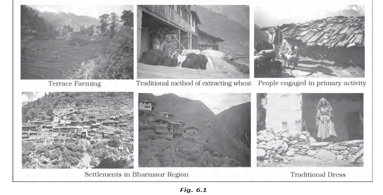
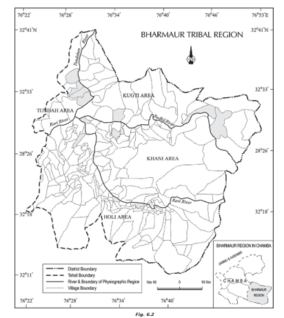
Bharmaur: Region and People
People, Livelihood and Development Challenges
- Population: In the 2011 Census, Bharmaur sub-division had 39,113 people, averaging 21 persons per sq km.
- Challenges: Harsh climate, a fragile environment and a limited resource base combined with historical geographical and political isolation and socio-economic deprivation.
- Traditional economy: Subsistence farming and pastoralism, especially food grains and livestock; sheep and goat rearing are important allied activities.
Integrated Tribal Development Project (ITDP)
ITDP Outcomes and Remaining Gaps
- Sectoral planning
- Planning for the development of specific sectors of the economy.
- Regional planning
- Planning that addresses spatial differences in development between regions.
- Target area
- A geographically defined area selected for focused development.
- Target group
- A particular population group selected for focused development support.
- Transhumance
- Seasonal movement associated with pastoral livelihoods.
- ITDP
- Integrated Tribal Development Project.
How do target area and target group planning differ?
What were the main aims and priorities of Bharmaur's ITDP?
State two benefits and one limitation of the ITDP in Bharmaur.
Quick recap
- Planning coordinates economic development; sectoral and regional planning address different needs.
- Target-area and target-group programmes aim to reduce regional and social disparities.
- Hill development adapts programmes to local topography, ecology and livelihoods.
- Drought-area planning combines employment and productive assets with watershed development and ecological restoration.
- Bharmaur is a high-altitude Gaddi tribal region with a traditional farming-pastoral economy.
- ITDP outcomes include improved infrastructure and social indicators, but benefits remain uneven and pastoralism has declined.
Sustainable Development
Development as a Multidimensional Concept
Development — A positive, irreversible transformation of a society’s economy, social conditions and environment.
How Development Takes Shape
- Interaction: Development reflects the changing relationship between human societies and their bio-physical environment.
- Technology and institutions: These shape human–environment interactions and are themselves transformed by the momentum of those interactions.
- Dimensions: Development involves connected changes in the economy, society and environment.
| Period | Main understanding |
|---|---|
| Post-World War II | Development was often equated with economic growth, measured by increases in GNP, per capita income and per capita consumption. |
| 1970s | Unequal distribution of growth led to the ideas of “redistribution with growth” and “growth and equity.” |
| By the 1980s | Development included widespread improvement in the social and material well-being of everyone in society, alongside health, education, equal opportunity, and political and civil rights. |
Emergence and Meaning of Sustainable Development
Why the Idea Emerged
- Environmental concern: In the late 1960s, awareness grew in the Western world about harmful environmental effects of industrial development.
- Influential publications: Ehrlich’s *The Population Bomb* (1968) and Meadows and others’ *The Limits to Growth* (1972) heightened concern about environmental limits.
Sustainable development — Development that meets the needs of the present without compromising the ability of future generations to meet their own needs.
Core Principles
- Balance: Consider ecological, social and economic aspects of development together.
- Conservation: Use and conserve resources so future generations can also meet their needs.
- Common future: Consider the development and well-being of humankind as a whole.
Development of the Sustainable Development Idea
- 1968Paul Ehrlich’s The Population Bomb added to environmental concern.
- 1972The Limits to Growth, by Meadows and others, further increased concern about environmental issues.
- 1987The UN World Commission on Environment and Development (WCED), headed by Norwegian Prime Minister Gro Harlem Brundtland, published Our Common Future, known as the Brundtland Report.
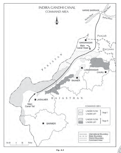
Case Study: Indira Gandhi Canal Command Area
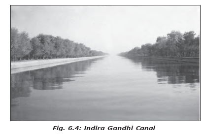
Indira Gandhi Canal — One of India’s largest canal systems, developed to irrigate dry parts of Rajasthan.
Canal System: Key Facts
- Earlier name: Rajasthan Canal.
- Origin and route: Conceived by Kanwar Sain; it starts at Harike Barrage in Punjab and runs through the Thar Desert, about 40 km from the Pakistan border on average.
- Scale: Planned system length is 9,060 km, serving a total culturable command area of 19.63 lakh hectares.
- Irrigation plan: About 70% of the command area was planned for flow irrigation and the rest for lift irrigation.
- Lift irrigation: Water is raised so it can flow against the slope of the land.
- Canal layout: Lift canals begin on the main canal’s left bank; canals on its right bank are flow channels.
Construction and Irrigation Timeline
- 1948Kanwar Sain conceived the canal.
- 31 March 1958The canal project was launched.
- Early 1960sIrrigation began in the Stage I command area.
- Mid-1980sThe Stage II command area began receiving irrigation.
| Stage | Districts covered | Culturable command area | Land and conditions |
|---|---|---|---|
| Stage I | Ganganagar, Hanumangarh and northern Bikaner | 5.53 lakh hectares | Gently undulating topography. |
| Stage II | Bikaner, Jaisalmer, Barmer, Jodhpur, Nagaur and Churu | 14.10 lakh hectares | Desert land with shifting sand dunes; summer temperatures can reach 50°C. |
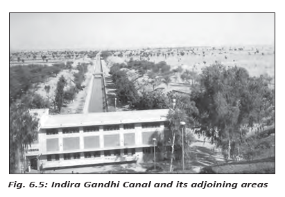
Effects of Canal Irrigation
| Aspect | Positive effects | Negative effects |
|---|---|---|
| Environment | Longer-lasting soil moisture and afforestation and pasture development under CAD helped green the land. | Intensive irrigation and excessive water use caused waterlogging and soil salinity. |
| Land condition | Greening helped reduce wind erosion and siltation of canal systems. | Waterlogging and salinity degrade the physical environment and threaten sustainable agriculture. |
Agricultural and Economic Changes
- Cultivation: Greater soil moisture expanded cultivated area and cropping intensity.
- Crop shift: Traditional gram, bajra and jowar were replaced by wheat, cotton, groundnut and rice as irrigation intensified.
- Productivity: Agricultural and livestock productivity initially increased substantially.
- Long-term risk: Waterlogging and salinity eventually hamper the sustainability of agriculture.
Canal Irrigation: Gains and Risks
- Canal water increases soil moisture → cultivated area and cropping intensity rise.
- More intensive cultivation → agricultural and livestock productivity initially increase.
- Excessive irrigation → waterlogging and soil salinity develop.
- Waterlogging and salinity → land degrades and long-term agricultural sustainability is threatened.
Measures to Promote Sustainable Development
Seven Measures for the Command Area
- 1. Manage water: Strictly implement the policy of protective irrigation in Stage I and extensive irrigation of crops and pasture development in Stage II.
- 2. Select suitable crops: Avoid water-intensive crops and encourage plantation crops such as citrus fruits.
- 3. Reduce conveyance losses: Implement CAD programmes, including lining watercourses, land development and levelling, and warabandi for equal distribution of canal water within an outlet’s command area.
- 4. Reclaim damaged land: Restore areas affected by waterlogging and soil salinity.
- 5. Restore ecosystems: Use afforestation, shelterbelt plantations and pasture development, especially in the fragile Stage II environment.
- 6. Support land allottees: Provide adequate financial and institutional support to land allottees from poor economic backgrounds.
- 7. Diversify the economy: Develop agriculture and allied activities alongside other economic sectors, linking basic villages, agro-service centres and market centres.
Sustainability Priorities
- Ecological sustainability: Five of the seven proposed measures focus on restoring ecological balance.
- Social sustainability: Requires financial and institutional support for poorer land allottees.
- Economic sustainability: Requires diversification beyond agriculture and animal husbandry, with functional links among villages, service centres and markets.
- Culturable command area
- Land within an irrigation command area that can be cultivated.
- Waterlogging
- Excess water in soil that harms land and crop conditions.
- Soil salinity
- Build-up of salts in soil that reduces its agricultural usefulness.
- Warabandi
- A system for equal distribution of canal water within the command area of an outlet.
- CAD
- Command Area Development programmes, including watercourse lining, land development and levelling, and water-distribution measures.
Define sustainable development.
Give two benefits and two environmental problems associated with Indira Gandhi Canal irrigation.
State the seven measures proposed for sustainable development in the canal command area.
Quick recap
- Development is a positive, irreversible change involving the economy, society and environment.
- By the 1980s, development included broad social and material well-being, not growth alone.
- The 1987 Brundtland Report defined sustainable development through present needs and future generations’ needs.
- The Indira Gandhi Canal was planned for 19.63 lakh hectares, with two stages and different irrigation approaches.
- Canal irrigation increased cultivation and productivity but also caused waterlogging and soil salinity.
- Sustainability needs suitable water use, ecological restoration, support for poorer landholders and economic diversification.
Geography — ALL CHAPTERS
1
Human Geography Nature And Scope
2
The World Population Distribution, Density And Growth
3
Human Development
4
Primary Activities
5
Secondary Activities
6
Tertiary And Quaternary Activities
7
Transport And Communication
8
International Trade
1
UNIT -I POPULATION DISTRIBUTION ,DENSITY, GROWTH AND COMPOSITION
2
UNIT -II HUMAN SETTLEMENTS
3
UNIT- III LAND RESOURCES AND AGRICULTURE
4
UNIT -III WATER RESOURCES
5
UNIT - III MINERAL AND ENERGY RESOURCES
6
UNIT -III PLANNING AND SUSTAINABLE DEVELOPMENT IN INDIAN CONTEXT
7
UNIT -IV TRANSPORT AND COMMUNICATION
8
UNIT -IV INTERNATIONAL TRADE
9
UNIT - V GEOGRAPHICAL PERSPECTIVE ON SELECTED ISSUES AND PROBLEMS