Class 12 Humanities . Geography . India People And Economy . Unit IV International Trade
Chapter 8: UNIT -IV INTERNATIONAL TRADE
Ch 8
Geography
Class 12 Humanities
Composition of Indias Exports and Imports
International Trade and India’s Foreign Trade
Composition of India’s Exports
Export trends
- Manufactured goods: The largest export group; it contributed 67.8% of export value in 2021–22.
- Agriculture and manufactured goods: Their shares generally declined over the period, despite year-to-year variation.
- Petroleum products: Their share rose to 16.4% in 2021–22; other commodities also increased overall.
- Ores and minerals: Their export share remained relatively small and broadly stable.
- Traditional agricultural exports: Exports such as cashew declined amid tough international competition.
- Growing agricultural exports: Floricultural products, fresh fruits, marine products and sugar recorded increases.
- Engineering goods: Their exports showed significant growth; China and other East Asian countries are major competitors.
- Gems and jewellery: They contribute a large share of India’s foreign trade.
| Commodity group | Value (Rs. crore) |
|---|---|
| Agriculture and allied products | 3,75,742 |
| Ores and minerals | 63,754 |
| Manufactured goods | 21,32,296 |
| Mineral fuels and lubricants | 5,15,310 |
Composition of India’s Imports
Historical shifts in imports
- 1950s–1960sFood shortages made foodgrains, capital goods, machinery and equipment major imports; imports exceeded exports despite import substitution efforts.
- After the 1970sGreen Revolution success ended foodgrain imports; fertilisers and petroleum became more prominent.
- 1973The energy crisis pushed up petroleum prices and increased India’s import expenditure.
Recent import patterns and reasons
- Fuel and petroleum: Import share rose to 31.6% in 2021–22. Petroleum is used as fuel and as an industrial raw material.
- Reasons for petroleum imports: Growing industrialisation, improved living standards and occasional international price rises.
- Capital goods: Their import share showed a steady decline.
- Food and allied products: Their share declined to 4.4% in 2021–22.
- Other important imports: Machinery and equipment, special steel, edible oil, chemicals, pearls and precious stones, gold, silver and non-ferrous metals.
| Commodity | Value (Rs. crore) |
|---|---|
| Fertilisers and fertiliser manufacturing | 1,05,796 |
| Edible oils | 1,41,532 |
| Pulp and waste paper | 11,934 |
| Non-ferrous metals | 4,99,766 |
| Iron and steel | 94,853 |
| Petroleum, oil and lubricants | 12,07,803 |
| Pearls, precious and semi-precious stones | 2,31,279 |
| Medical and pharmaceutical products | 67,545 |
| Chemical products | 3,08,882 |
- Largest listed import: Petroleum, oil and lubricants (Rs. 12,07,803 crore) in 2021–22.
- Next largest listed items: Non-ferrous metals, chemical products, pearls and precious stones, then edible oils.
Direction of Trade
Trade links and transport
- Trading relations: India trades with most countries and major trading blocs.
- Largest listed region: Asia and ASEAN had the highest import value among the regions shown in both years.
- Policy aim: India aims to double its share in international trade within five years.
- Measures: Import liberalisation, reduced import duties, delicensing and a shift from process patents to product patents.
- Transport routes: Most foreign trade moves by sea and air; a smaller share travels by land to Nepal, Bhutan, Bangladesh and Pakistan.
Describe the major changes in the composition of India’s exports.
How has India’s import basket changed since the 1950s and 1960s?
What are the main features of India’s direction of trade?
Quick recap
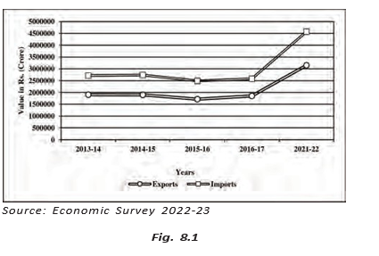
- India’s foreign trade has grown greatly in value, but imports remain higher than exports.
- Manufactured goods are the largest export group; their share was 67.8% in 2021–22.
- Engineering exports have grown, while traditional agricultural exports face strong competition.
- The Green Revolution ended foodgrain imports; petroleum and fertilisers became more prominent.
- Fuel is a major import because it serves as energy and industrial raw material.
- Asia and ASEAN are India’s largest import region in the listed regional data.
- Most of India’s foreign trade moves by sea and air.
Sea Ports as Gateways of International and Airports
India’s Sea Ports and Trade
Sea port — A coastal or river-side facility where ships load and unload goods, linking inland areas with domestic and international trade.
Role and distribution of ports
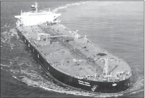
- Coastline: India is surrounded by the sea on three sides and has a long coastline; water offers low-cost transport when seas are not turbulent.
- Port names: The suffix *pattan* in some place names means port, reflecting India’s long seafaring tradition.
- Distribution: India’s west coast has more ports than its east coast.
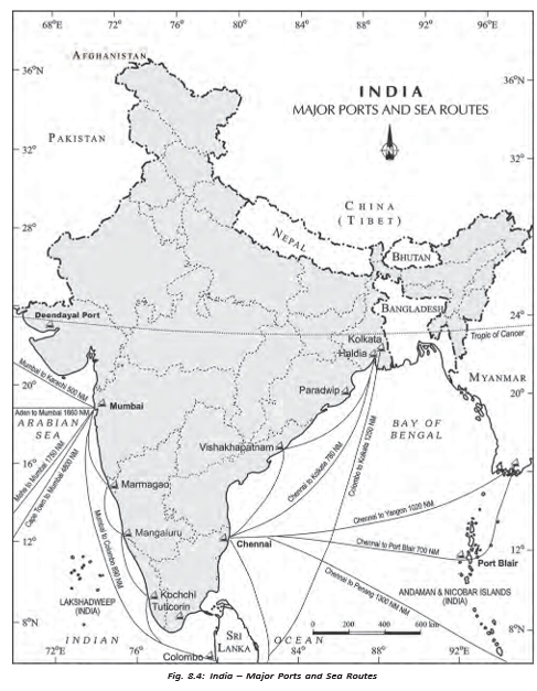
- Port categories: India has 12 major ports and 200 minor or intermediate ports; major ports handle the larger share of traffic.
- Administration: The Central Government makes policy and regulates major ports; state governments regulate minor ports.
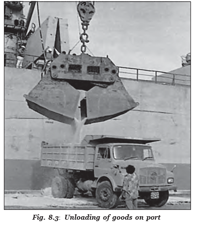
Hinterland — The inland area served by a port; the boundaries are not fixed and the hinterlands of different ports may overlap.
Ports, colonial trade and transport links
- European traders and British colonisation increased the importance of ports as gateways of international trade.
- The British used ports to draw resources from their hinterlands.
- Railway expansion linked local markets to regional markets, then national markets and international markets.
- Partition in 1947 transferred Karachi to Pakistan and Chittagong to erstwhile East Pakistan, now Bangladesh.
- To replace lost port capacity, India developed Kandla in the west and Diamond Harbour near Kolkata on the Hugli in the east.
Growth and modernisation
- Expansion: After Independence, ports continued to grow and now handle large volumes of domestic and overseas trade.
- Infrastructure: Most ports have modern infrastructure; private entrepreneurs have been invited to support modernisation and bring ports closer to international standards.
- Capacity: Cargo-handling capacity rose from 20 million tonnes in 1951 to more than 837 million tonnes in 2016.
Key dates in port development
- 1859Chennai Port was built as an artificial harbour.
- 1947Partition transferred Karachi and Chittagong ports outside India.
- 1951India’s port cargo-handling capacity was 20 million tonnes.
- 1961Marmagao was remodelled and gained importance for iron-ore exports to Japan.
- 2016Port cargo-handling capacity exceeded 837 million tonnes.
| Port | Location and role | Main hinterland / key details |
|---|---|---|
| Deendayal (Kandla) | At the head of the Gulf of Kuchchh; developed for western and north-western India and to ease pressure on Mumbai. Handles large quantities of petroleum, petroleum products and fertilisers. | Western and north-western parts of India; the Vadinar offshore terminal helps reduce pressure on the port. |
| Mumbai | Natural harbour and India’s biggest port; close to major routes serving the Middle East, Mediterranean, North Africa, North America and Europe. It is 20 km long and 6–10 km wide, with 54 berths and India’s largest oil terminal. | Madhya Pradesh, Maharashtra, Gujarat, Uttar Pradesh and parts of Rajasthan. |
| Jawaharlal Nehru (Nhava Sheva) | Satellite port developed to relieve pressure on Mumbai. | India’s largest container port. |
| Marmagao | Natural harbour at the entrance of the Zuari estuary in Goa; remodelled in 1961 for iron-ore exports to Japan. | Goa, Karnataka and southern Maharashtra; the Konkan Railway extended its hinterland. |
| New Mangalore | Karnataka port; exports iron ore and iron concentrates, and handles fertilisers, petroleum products, edible oils, coffee, tea, wood pulp, yarn, granite, molasses and other cargo. | Karnataka. |
| Kochchi | Natural harbour at the head of Vembanad Kayal, known as the ‘Queen of the Arabian Sea’; close to the Suez–Colombo route. | Kerala, southern Karnataka and south-western Tamil Nadu. |
| Kolkata | On the Hugli, 128 km inland from the Bay of Bengal; developed by the British. Its importance declined as exports shifted to other ports, including Vishakhapatnam and Paradwip, and satellite port Haldia. Silt accumulation in the Hugli obstructs the sea link. | Uttar Pradesh, Bihar, Jharkhand, West Bengal, Sikkim and the north-eastern states; also provides port facilities to land-locked Nepal and Bhutan. |
| Haldia | 105 km downstream from Kolkata; built to ease congestion there. Handles bulk cargo, including iron ore, coal, petroleum and petroleum products, fertilisers, jute and jute products, cotton and cotton yarn. | Serves as Kolkata’s satellite port. |
| Paradwip | In the Mahanadi delta, about 100 km from Cuttack; has a deep harbour suited to very large vessels and was developed mainly for large-scale iron-ore exports. | Odisha, Chhattisgarh and Jharkhand. |
| Visakhapatnam | Andhra Pradesh; a land-locked harbour connected to the sea by a channel cut through solid rock and sand. Its outer harbour handles iron ore, petroleum and general cargo. | Andhra Pradesh and Telangana. |
| Chennai | One of the oldest east-coast ports; an artificial harbour built in 1859. Shallow coastal waters make it less suitable for large ships. | Tamil Nadu and Puducherry. |
| Ennore | Newly developed port, 25 km north of Chennai, built to relieve pressure on Chennai Port. | Tamil Nadu. |
| Tuticorin | Developed to ease pressure on Chennai; handles coal, salt, food grains, edible oils, sugar, chemicals and petroleum products. | Southern Tamil Nadu and nearby areas. |
Airports and International Trade
Air transport in international trade — Air transport carries goods quickly over long distances, especially high-value or perishable goods.
| Point | Air transport | Ocean transport |
|---|---|---|
| Time and goods | Fast; suitable for high-value and perishable goods over long distances. | Slower, but suited to large volumes of trade. |
| Cost and cargo | Very costly and unsuitable for heavy, bulky commodities. | Low-cost transport, particularly where sea conditions are not turbulent. |
| Trade participation | Cost and cargo limits reduce its share of international trade compared with ocean routes. | Carries a larger share of international trade. |
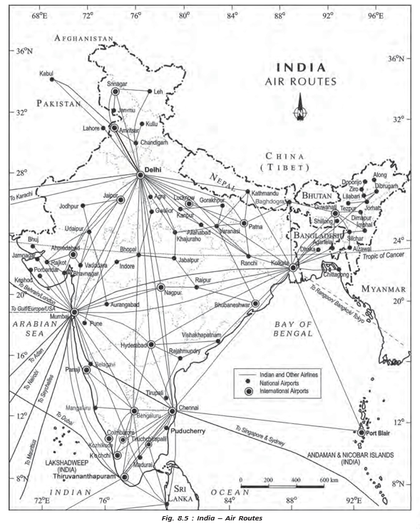
Airports in India
- Major airports: The 2016–17 Annual Report recorded 25 major airports: Ahmedabad, Bengaluru, Chennai, Delhi, Goa, Guwahati, Hyderabad, Kolkata, Mumbai, Thiruvananthapuram, Srinagar, Jaipur, Calicut, Nagpur, Coimbatore, Cochin, Lucknow, Pune, Chandigarh, Mangaluru, Vishakhapatnam, Indore, Patna, Bhubaneswar and Kannur.
- UDAN: Since 2017, the scheme has operationalised 73 unserved or underserved airports, including 9 heliports and 2 water aerodromes, as reported in 2023.
- Major port
- A port whose policy and regulation are handled by the Central Government.
- Minor or intermediate port
- A port whose policy and functions are regulated by the state government.
- Hinterland
- The inland area served by a port; boundaries can shift or overlap.
- Satellite port
- A nearby port developed to reduce congestion or pressure at a larger port.
How do major and minor ports differ in administration?
Why was Haldia developed?
Why is air transport’s share of international trade lower than that of ocean transport?
Quick recap
- Ports: India has 12 major and 200 minor or intermediate ports; major ports handle the larger share of traffic.
- Hinterlands: A port serves an inland area, but hinterland boundaries can shift and overlap.
- Colonial links: Railways connected port hinterlands to wider markets; Partition transferred Karachi and Chittagong outside India.
- Port growth: Cargo-handling capacity rose from 20 million tonnes in 1951 to over 837 million tonnes in 2016.
- Port examples: Nhava Sheva is India’s largest container port; Paradwip has a deep harbour; Haldia eases congestion at Kolkata.
- Air transport: It is fast and suited to high-value or perishable goods, but costly and unsuitable for heavy, bulky cargo.
- Airports: The 2016–17 report listed 25 major airports; by 2023, UDAN had operationalised 73 underserved or unserved airports, heliports and water aerodromes.
Geography — ALL CHAPTERS
1
Human Geography Nature And Scope
2
The World Population Distribution, Density And Growth
3
Human Development
4
Primary Activities
5
Secondary Activities
6
Tertiary And Quaternary Activities
7
Transport And Communication
8
International Trade
1
UNIT -I POPULATION DISTRIBUTION ,DENSITY, GROWTH AND COMPOSITION
2
UNIT -II HUMAN SETTLEMENTS
3
UNIT- III LAND RESOURCES AND AGRICULTURE
4
UNIT -III WATER RESOURCES
5
UNIT - III MINERAL AND ENERGY RESOURCES
6
UNIT -III PLANNING AND SUSTAINABLE DEVELOPMENT IN INDIAN CONTEXT
7
UNIT -IV TRANSPORT AND COMMUNICATION
8
UNIT -IV INTERNATIONAL TRADE
9
UNIT - V GEOGRAPHICAL PERSPECTIVE ON SELECTED ISSUES AND PROBLEMS