Class 12 Humanities . Geography . India People And Economy . Unit III Water Resources
Chapter 4: UNIT -III WATER RESOURCES
Ch 4
Geography
Class 12 Humanities
Water Resources and Water Demand in India
Water Resources: Availability and Scarcity
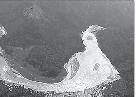
Water scarcity — A shortage of usable water caused by rising demand and shrinking supplies due to overuse and pollution.
Global water context
- Water cycle: Water is a cyclic resource, but only a small share is readily available for human use.
- Distribution: About 71% of Earth’s surface is covered by water; freshwater makes up only about 3% of all water.
- Variation: Freshwater availability varies across places and over time.
- Competition: Sharing and controlling scarce water can create disputes among communities, regions and states.
- Pressures: Population shifts, technological change, environmental degradation and increasing demand may intensify water scarcity.
- Management: Assessing water resources, using them efficiently and conserving them are essential for development.
Water Resources of India
| Measure | Amount |
|---|---|
| Share of world’s surface area | About 2.45% |
| Share of world’s water resources | About 4% |
| Share of world population | More than 17% |
| Water from annual precipitation | About 4,000 cubic km |
| Surface water and replenishable groundwater | 1,869 cubic km |
| Beneficially utilisable water | About 60% of the above; total utilisable resource is 1,122 cubic km |
Surface Water Resources
Surface water — Water present on the land surface in rivers, lakes, ponds and tanks.
River flow and usable surface water
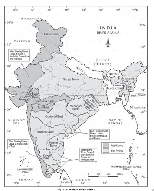
- River network: India has about 10,360 rivers and tributaries longer than 1.6 km.
- Annual flow: Mean annual flow across Indian river basins is estimated at 1,869 cubic km.
- Usable share: Only about 690 cubic km, or 32% of available surface water, can be used because of topographical, hydrological and other constraints.
- Controls on flow: River flow depends on the size of its catchment or basin and the rainfall it receives.
- Seasonality: Rainfall varies greatly across India and is concentrated mainly in the monsoon season.
| Point | Ganga–Brahmaputra–Barak basins | Southern river basins |
|---|---|---|
| Water distribution | High rainfall and large catchments; these basins cover about one-third of India but contain about 60% of its surface water resources. | The Godavari, Krishna and Kaveri are important south Indian rivers. |
| Water use development | Much of the flow in the Ganga and Brahmaputra basins is yet to be harnessed. | Much of the annual flow in the Godavari, Krishna and Kaveri has been harnessed. |
Groundwater Resources
Groundwater availability and use
- Total resource: India has about 432 cubic km of replenishable groundwater.
- High utilisation: Use is especially high in north-western river basins and parts of southern India.
- Very high-use states: Punjab, Haryana, Rajasthan and Tamil Nadu.
- Low-use states: Chhattisgarh, Odisha and Kerala use only a small share of their groundwater potential.
- Moderate-use states: Gujarat, Uttar Pradesh, Bihar, Tripura and Maharashtra.
Groundwater pressure and its consequences
- Continued growth in water demand
- Potential gap between water demand and available supplies
- Less secure water supplies can hinder development
- Severe shortages may cause social upheaval and disruption
Lagoons and Backwaters
Coastal water bodies
- Formation: India’s coastline is extensive and deeply indented in some states, resulting in lagoons and lakes.
- Important states: Kerala, Odisha and West Bengal have substantial surface water in these coastal water bodies.
- Uses: Though generally brackish, their water supports fishing and irrigation of certain paddy varieties and coconut.
Water Demand and Utilisation
Why agriculture dominates water demand
- Agrarian dependence: About two-thirds of India’s population has traditionally depended on agriculture.
- Planning priority: Irrigation development received high priority in Five Year Plans to raise agricultural production.
- Multipurpose projects: Examples include Bhakra-Nangal, Hirakud, Damodar Valley, Nagarjuna Sagar and the Indira Gandhi Canal Project.
- Present pattern: Irrigation is the largest component of India’s water demand.
| Sector | Surface water used | Groundwater used |
|---|---|---|
| Agriculture | 89% | 92% |
| Industry | 2% | 5% |
| Domestic use | 9% | Lower than its surface-water share; exact share not stated |
Changing demand
- Current pattern: Agriculture’s share of total water use is much greater than that of other sectors.
- Likely shift: With development, the shares used by industry and households are expected to rise.
Demand for Water for Irrigation
Why irrigation is needed
- Rainfall is uneven across space and concentrated in the monsoon
- Dry seasons, drought-prone regions and monsoon breaks create water shortages
- High-water crops such as rice, sugarcane and jute need dependable supplies
- Irrigation supplies moisture when rainfall is inadequate
- Assured water supports multiple cropping, higher productivity and high-yielding varieties
Irrigation and agricultural development
- Need across regions: North-western India and the Deccan Plateau are rainfall-deficient and drought-prone; dry winters and summers affect much of the country.
- Monsoon risk: Even rainy states such as West Bengal and Bihar can face harmful dry spells when the monsoon breaks or fails.
- Productivity: Irrigated land is generally more productive and makes multiple cropping possible.
- Crop varieties: High-yielding varieties require regular moisture, which reliable irrigation can supply.
- Green Revolution: Irrigation helped the strategy succeed especially in Punjab, Haryana and western Uttar Pradesh.
| Region | Net sown area irrigated | Key detail |
|---|---|---|
| Punjab | More than 85% | 76.1% of net irrigated area is supplied by wells and tubewells. |
| Haryana | More than 85% | 51.3% of net irrigated area is supplied by wells and tubewells. |
| Western Uttar Pradesh | More than 85% | Wheat and rice are grown mainly with irrigation. |
Impacts of excessive groundwater use
- Heavy groundwater use through wells and tubewells
- Over-withdrawal lowers the groundwater table
- Intensive irrigation in Punjab, Haryana and western Uttar Pradesh is increasing soil salinity and depleting groundwater.
- Over-withdrawal in parts of Rajasthan and Maharashtra has increased fluoride concentration in groundwater.
- Groundwater arsenic concentration has increased in parts of West Bengal and Bihar.
Pradhan Mantri Krishi Sinchayee Yojana
Launch
- 2015–16The Central Government launched PMKSY to expand protective irrigation and support rural prosperity.
Main objectives
- Har Khet Ko Pani: Extend access to water on farms and expand the area under assured irrigation.
- Integrated water use: Link water sources and distribution, and promote efficient use through suitable technologies and practices.
- Per Drop More Crop: Improve on-farm water efficiency, reduce wastage and increase water availability.
- Conservation: Encourage sustainable water conservation and water-saving irrigation technologies.
- Rain-fed areas: Support integrated development through soil and water conservation, groundwater regeneration and livelihood options.
Emerging Water Problems
Growing pressure on usable water
- Population increases
- Per capita water availability declines
- Industrial, agricultural and domestic effluents pollute water sources
- The supply of usable water shrinks further
- Catchment
- The area whose rainfall and runoff drain into a river or water body.
- Utilisable water
- The portion of available water that can be put to beneficial use.
- Brackish water
- Water that is more saline than freshwater but less saline than seawater.
- Net sown area
- The area sown with crops at least once during an agricultural year.
Why is utilisable surface water in India much less than its total river flow?
How does irrigation support agricultural production?
Name two consequences of excessive groundwater withdrawal.
Quick recap
- Only about 3% of the world’s water is freshwater, and its availability varies over space and time.
- India has 1,122 cubic km of utilisable water; only about 690 cubic km of surface water can be used.
- The Ganga–Brahmaputra–Barak basins hold about 60% of surface water while covering roughly one-third of India.
- Agriculture accounts for 89% of surface-water and 92% of groundwater utilisation.
- Irrigation improves agricultural production, but excessive use can deplete groundwater and increase soil salinity or groundwater contaminants.
- PMKSY, launched in 2015–16, promotes assured irrigation, efficient water use and sustainable conservation.
- Population growth and pollution from industrial, agricultural and domestic effluents reduce usable water availability.
Deterioration of Water Quality
Water Quality and Its Deterioration
Water quality — The purity of water, or how free it is from unwanted foreign substances.
How Water Becomes Polluted
- Pollutants: Micro-organisms, chemicals, industrial waste and other wastes enter water bodies.
- Movement: Toxic substances dissolve in water or remain suspended in it; some pollutants seep down and contaminate groundwater.
- Effects: Pollution makes water unfit for human use and damages aquatic systems.
Water Conservation and Management
Why Conservation Is Needed
- Pressure on freshwater: Availability is declining while demand is increasing, so conservation and effective management are essential for sustainable development.
- Limited alternative: Sea and ocean water is not a major practical source because desalination is costly.
- Public action: India needs effective policies, laws and measures, alongside water-saving technologies and pollution prevention.
| Measure | Purpose |
|---|---|
| Water-saving technologies | Reduce water use and wastage. |
| Watershed development | Improve the conservation and management of water within a watershed. |
| Rainwater harvesting | Collect and store rainwater for later use or replenishment. |
| Recycling and reuse | Use water again to reduce demand for fresh water. |
| Conjunctive use | Use water sources together to help sustain supply over the long term. |
| Pollution prevention | Protect available freshwater from further degradation. |
Prevention of Water Pollution
Sources and Pattern of River Pollution
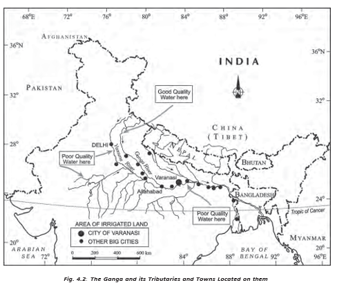
- Less densely populated upper stretches in hilly areas generally retain better river-water quality.
- In the plains, rivers are heavily used for irrigation, drinking, domestic needs and industry.
- Drains carry agricultural fertilisers and insecticides, domestic solid and liquid waste, and industrial effluents into rivers.
- Pollutants accumulate to especially high concentrations in summer, when river flow is low.
Monitoring and Pollution Hotspots
- Monitoring: The Central Pollution Control Board (CPCB), working with State Pollution Control Boards, monitors national aquatic resources at 507 stations.
- Main contamination: Monitoring data identify organic and bacterial contamination as the continuing main sources of river pollution.
- Yamuna: Identified as the country’s most polluted river stretch between Delhi and Etawah.
- Other severely polluted rivers/stretches: Sabarmati at Ahmedabad; Gomti at Lucknow; Kali; Adyar; Cooum throughout its stretches; Vaigai at Madurai; Musi at Hyderabad; and Ganga at Kanpur and Varanasi.
- Groundwater: Pollution is associated with high concentrations of heavy or toxic metals, fluoride and nitrates in different parts of India.
Water-Pollution Legislation and Reported Industry Locations
- 1974The Water (Prevention and Control of Pollution) Act was enacted.
- 1977The Water Cess Act was intended to help reduce pollution but had only a marginal impact.
- 1986The Environment Protection Act was enacted.
- 1997A total of 251 polluting industries were located along rivers and lakes.
Control and Public Awareness
- Implementation gap: The pollution-control laws have not been implemented effectively; the Water Cess Act has made only marginal impact.
- Public awareness: People need to understand the importance of water and the effects of water pollution.
- Public action: Awareness and action can help reduce pollutants from agricultural activities and domestic and industrial discharges.
Recycle and Reuse of Water
Uses and Benefits
- Reclaimed wastewater: Water of lower quality can be used by industries for cooling and firefighting, reducing their water costs.
- Household reuse: Water from bathing and washing utensils can be reused for gardening.
- Vehicle washing: Water used to wash vehicles can also be used for gardening.
- Benefit: Reuse saves better-quality water for drinking and helps replenish available water supplies.
- Scope: Recycling is currently practised on a limited scale, but it has enormous potential to increase freshwater availability.
- Water quality
- Purity of water and freedom from unwanted foreign substances.
- Reclaimed wastewater
- Wastewater treated or reused for suitable purposes rather than discharged or used as fresh drinking water.
- Conjunctive use
- Coordinated use of different water sources to sustain supply.
Quick recap
- Pollutants can dissolve or remain suspended in water, harm aquatic systems and make water unsafe for human use.
- Conservation measures include water-saving technology, watershed development, rainwater harvesting, recycling, reuse and conjunctive use.
- River pollution comes from agricultural, domestic and industrial drains; low summer flow increases pollutant concentrations.
- CPCB and State Pollution Control Boards monitor water at 507 stations; organic and bacterial contamination are major river pollutants.
- The Yamuna between Delhi and Etawah is identified as the most polluted stretch; groundwater may contain toxic metals, fluoride and nitrates.
- Pollution laws have had limited effect without effective implementation and public awareness and action.
- Reusing reclaimed and household water for suitable purposes preserves better-quality freshwater for drinking.
Watershed Management
Meaning and Objectives
Watershed management — Efficiently managing and conserving surface and groundwater, while conserving, regenerating and wisely using all resources within a watershed.
Main aims
- Water conservation: Reduce runoff and store water to recharge groundwater using methods such as percolation tanks and recharge wells.
- Integrated resource use: Conserve, regenerate and wisely use land, water, plants, animals and human resources.
- Balance: Bring society’s needs into balance with natural resources.
- Participation: The success of watershed development depends greatly on community involvement.
Watershed Programmes in India
| Programme or location | Key features |
|---|---|
| Haryali | A Central Government-sponsored project that enables rural communities to conserve water for drinking, irrigation, fisheries and afforestation. Gram Panchayats implement it with people’s participation. |
| Atal Bhujal Yojana (Atal Jal) | Implemented in 8,220 water-stressed Gram Panchayats across 229 blocks/talukas in 80 districts of Gujarat, Haryana, Karnataka, Madhya Pradesh, Maharashtra, Rajasthan and Uttar Pradesh. These states account for about 37% of India’s water-stressed blocks, classified as over-exploited, critical or semi-critical. It promotes a shift from consumption to conservation and smart water management. |
| Neeru-Meeru, Andhra Pradesh | People’s participation in constructing water-harvesting structures such as percolation tanks, dug-out ponds (johads) and check dams. |
| Arvary Pani Sansad, Alwar, Rajasthan | People’s participation in constructing water-harvesting structures such as percolation tanks, dug-out ponds (johads) and check dams. |
| Tamil Nadu | Water-harvesting structures are compulsory in houses; buildings cannot be constructed without them. |
Progress and challenge
- Progress: Some projects have helped rejuvenate local environments and economies.
- Challenge: Successful examples are limited; most programmes remain at an early stage.
- Need: Raise public awareness and strengthen integrated water resource management to ensure sustainable water availability.
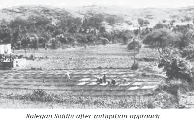
Ralegan Siddhi: A Watershed Development Case Study
Ralegan Siddhi’s transformation
- 1975Ralegan Siddhi, in Ahmadnagar district, Maharashtra, faced poverty and illicit liquor production. A retired army personnel settled there and began leading watershed development.
- After the percolation tank was builtThe tank initially failed to hold water because its embankment leaked; villagers repaired it through voluntary labour.
Background and community action
- Leadership and participation: The village leader promoted family planning and voluntary labour, reducing dependence on government financial aid. Villagers working outside the village also contributed a month’s salary each year.
- Community rules: Open grazing, tree felling and liquor production were prohibited; stall-feeding was encouraged.
- Shared costs: Voluntary contributions of labour and money spread the cost of village projects across the community.
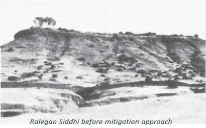
Watershed work and its effects
- A percolation tank was built, but its leaking embankment meant it could not initially hold water.
- Villagers repaired the embankment through voluntary labour.
- The seven wells below the tank filled with water in summer for the first time in living memory.
- Improved water availability helped support agriculture and wider village development.
Social and economic changes
- Tarun Mandal: The youth group worked against dowry, caste discrimination and untouchability.
- Farming: Water-intensive sugarcane was prohibited; pulses, oilseeds and lower-water cash crops were encouraged.
- Local governance: Local-body elections were based on consensus, and informal Nyay Panchayats handled disputes; no case had been referred to the police.
- Self-reliance: A school costing Rs. 22 lakh was built using village resources, without donations; borrowed money was repaid.
- Livelihoods: A system of shared labour helped landless labourers gain employment; villagers planned to buy land for them in nearby villages.
Outcomes and continuing concerns
- Achievements: Water became adequate and agriculture flourished; community pride, cooperation and self-reliance grew.
- Concern: Fertiliser and pesticide use remained very high.
- Continuity: The village’s future depends partly on whether the next generation continues the community-led work.
- Johad
- A dug-out pond.
- Nyay Panchayat
- An informal court established to handle local disputes.
What are the main aims of watershed management?
How did watershed development transform Ralegan Siddhi?
Quick recap
- Watershed management conserves water and coordinates the wise use of natural and human resources.
- Community participation is central to successful watershed development.
- Haryali, Atal Jal and community initiatives support water conservation through different approaches.
- Ralegan Siddhi combined water harvesting with voluntary labour, community rules and self-reliance.
- The village gained reliable water and flourishing agriculture, but high chemical use and continuity of community effort remain concerns.
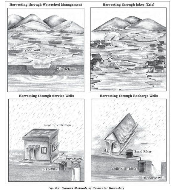
Rainwater Harvesting
Rainwater Harvesting: Meaning and Benefits
- Meaning: Rainwater harvesting captures and stores rainwater for use or to recharge groundwater aquifers.
- Benefits: It increases water availability, helps check falling groundwater levels and improves groundwater quality by diluting contaminants.
- Protection: It can reduce soil erosion and flooding, and help prevent saltwater intrusion in coastal areas.
Traditional and Modern Methods
How Harvesting Supports Water Availability
- Collect rainwater or guide it underground
- → Store water and recharge aquifers
- → Improve groundwater availability and reduce dependence on pumping
- → Support domestic needs and save pumping energy
Other Measures and Water Pricing
- Additional measures: Desalination can help in coastal areas and in arid and semi-arid regions with brackish water.
- Water transfer: Interlinking rivers can transfer water from surplus areas to water-deficit areas.
- Water pricing: Pricing is an important issue for individual users, households and communities.
National Water Policy, 2012
- Purpose: The National Water Policy, 2012 proposes a framework for action with a unified national perspective on water resources.
- Priorities: It calls for conservation, efficient use and management of water, with priority for drinking water, sanitation, food security and minimum ecosystem needs.
- Implementation: It recommends water-use benchmarks and auditing, climate-change adaptation, and community participation in managing water projects and services.
Jal Kranti Abhiyan
Key Water Initiatives
- 2012The National Water Policy set recommendations for conserving, developing and improving the management of water resources.
- 2015–16Jal Kranti Abhiyan was launched to promote water security and community involvement.
- Aquifer recharge
- The replenishment of underground water stores.
- Kund or Tanka
- A covered underground tank used in Rajasthan to store harvested rainwater.
- Water footprint
- A benchmark used to assess water use for a particular purpose.
- Model command area
- An area of about 1,000 hectares identified under Jal Kranti Abhiyan.
State four benefits of rainwater harvesting.
Name the main recommendations of the National Water Policy, 2012.
What are the main components of Jal Kranti Abhiyan?
Quick recap
- Rainwater harvesting stores rainwater or recharges aquifers, improving water availability and groundwater conditions.
- Traditional methods include surface-storage bodies and Rajasthan's Kund or Tanka tanks; modern methods harvest rooftop and open-space rain.
- Harvesting can reduce groundwater dependence, help bridge supply gaps and save pumping energy.
- The National Water Policy, 2012 prioritises essential needs, efficient use, climate adaptation and community participation.
- Jal Kranti Abhiyan (2015–16) advances water security through local action, recharge, pollution abatement and public awareness.
- The Abhiyan links water security with livelihood and food security.
Geography — ALL CHAPTERS
1
Human Geography Nature And Scope
2
The World Population Distribution, Density And Growth
3
Human Development
4
Primary Activities
5
Secondary Activities
6
Tertiary And Quaternary Activities
7
Transport And Communication
8
International Trade
1
UNIT -I POPULATION DISTRIBUTION ,DENSITY, GROWTH AND COMPOSITION
2
UNIT -II HUMAN SETTLEMENTS
3
UNIT- III LAND RESOURCES AND AGRICULTURE
4
UNIT -III WATER RESOURCES
5
UNIT - III MINERAL AND ENERGY RESOURCES
6
UNIT -III PLANNING AND SUSTAINABLE DEVELOPMENT IN INDIAN CONTEXT
7
UNIT -IV TRANSPORT AND COMMUNICATION
8
UNIT -IV INTERNATIONAL TRADE
9
UNIT - V GEOGRAPHICAL PERSPECTIVE ON SELECTED ISSUES AND PROBLEMS