Class 6 . Social Science . Exploring Society India And Beyond . Landforms and Life
Chapter 3: LANDFORMS AND LIFE
Ch 3
Social Science
Class 6
Introduction & Mountains
Landforms
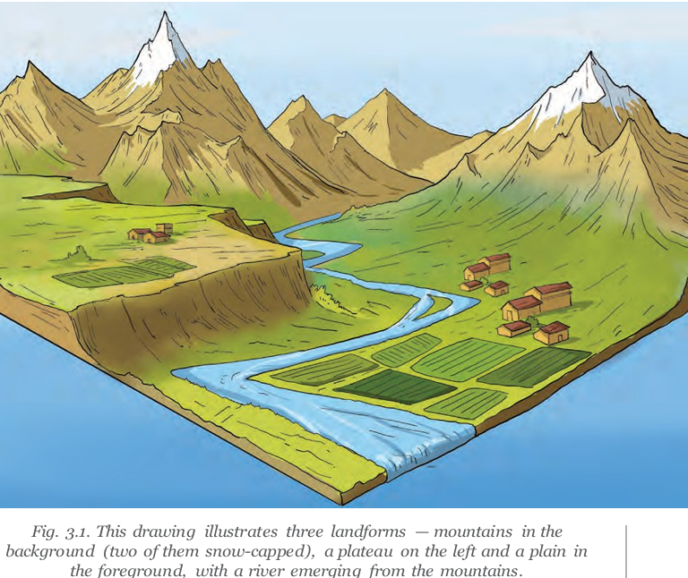
Mountains and Hills
Hill — A hill is a highland lower than a mountain, with less steep slopes and a rounded top.
Precipitation — Precipitation is water from the atmosphere reaching the ground; rain, snow and hail are common forms.
Snow and Hail
- Snow: It falls when the air at higher altitudes is cold enough and can cover the landscape.
- Solid precipitation: Snow and hailstones are water precipitating in a solid state.
Mountain Ranges and Important Peaks
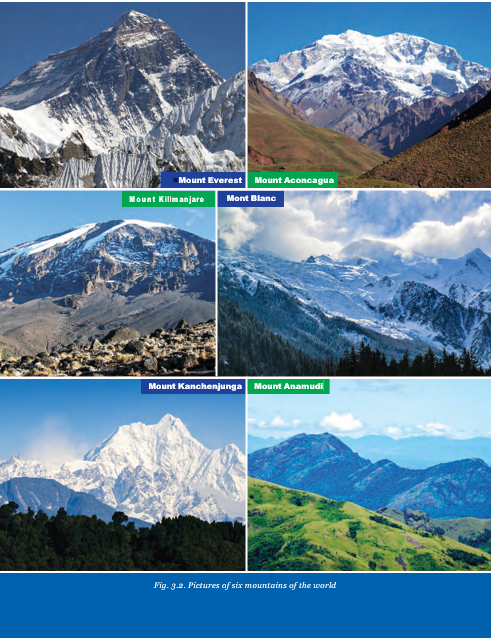
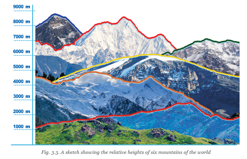
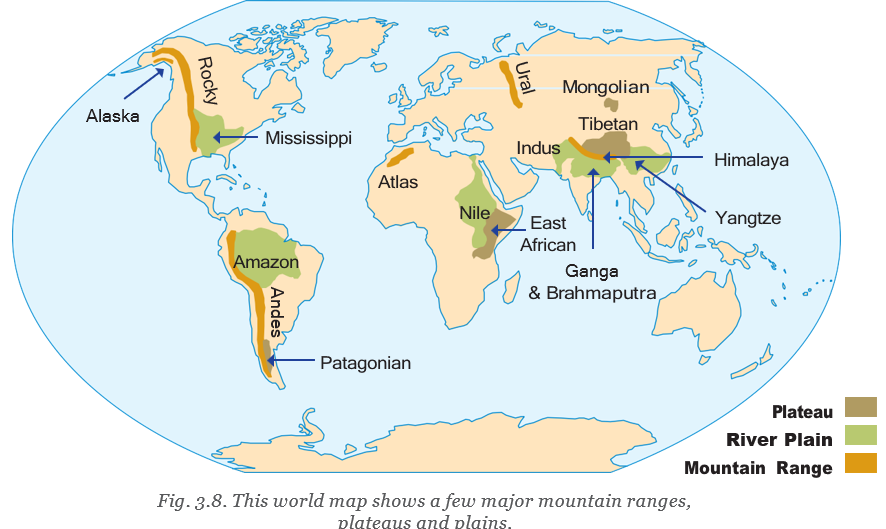
- Himalayas: In Asia; Mount Everest, between Tibet (China) and Nepal, and Kanchenjunga, between Nepal and Sikkim, are its two highest peaks.
- Andes: In South America; Mount Aconcagua is the range’s highest peak.
- Alps: In Europe; Mont Blanc is the highest mountain of the Alps.
- Kilimanjaro: An isolated mountain in eastern Africa, not part of a mountain range.
- Anamudi: Also called Anai Peak; it is the highest mountain in south India and is in Kerala.
| Point | Young mountains | Old mountains and hills |
|---|---|---|
| Shape | Often tall, with sharp peaks | Often shorter, with rounded tops |
| Formation and change | Formed relatively recently in Earth’s history, though still millions of years ago | Rounded over time by erosion |
| Example | The Himalayas | The Aravalli Range |
Mountains in the Present
- Ongoing processes: Upliftment and erosion continue in the Himalayas.
- Growing mountains: Some mountains, including the Himalayas, are still increasing in height.
- Montane forest
- A type of forest that grows in mountainous regions.
- Moss
- A small green plant without flowers or true roots, often spreading as a cushion-like cover.
Quick recap
- A landform is a physical feature on Earth’s surface; the three broad types are mountains, plateaus and plains.
- Landforms form over millions of years and have different climates, plants, animals and patterns of human settlement.
- Mountains are higher than their surroundings, with broad bases, steep slopes and narrow summits; hills are lower and rounder.
- Precipitation includes rain, snow and hail; snow and hail are solid-state precipitation.
- The Himalayas, Alps and Andes are major ranges; Kilimanjaro is an isolated mountain.
- Young mountains tend to have sharp peaks, while older mountains and hills, such as the Aravallis, are often rounded by erosion.
- Upliftment and erosion continue in the Himalayas, which are still growing.
Mountain Environment
Mountain Plants and Animals
Mountain vegetation
- Montane forests cover many mountain slopes and commonly contain conifers such as pine, fir, spruce and deodar.
- Conifers are tall, cone-shaped trees with thin, pointed leaves.
- Higher altitudes are too harsh for many trees; grasses, mosses and lichens grow there instead.
Mountain wildlife
- Habitats: Mountain forests, rivers, lakes, grasslands and caves support diverse wildlife.
- Examples: Golden eagle, peregrine falcon, Canadian lynx, snow leopard, ibex, Himalayan tahr, mountain hare, yak, grey fox and black bear.
The Himalayas and the Ganga
Geographical links
- Himalaya: The mountain range lies in northern India and stretches from the western to the eastern oceans.
- Ganga: The river descends from the Himalayas; mountain winds can carry its spray and cool people in the mountains.
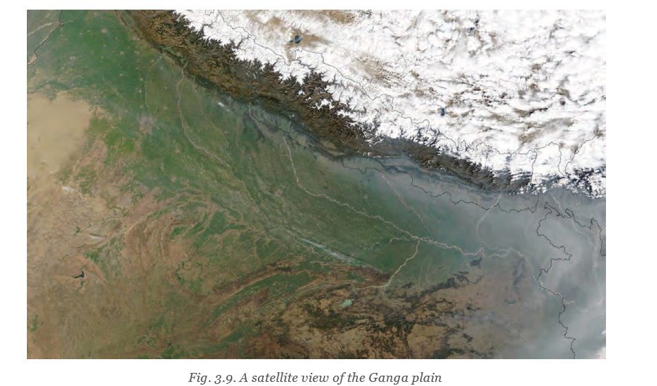
- Tributaries: The Ganga is nearly 2,500 km long. Himalayan tributaries include the Yamuna and Ghaghara; the Son (Sone) rises in the Vindhya Range, south of the Ganga Plain.
Life in the Mountains
Terrain and livelihoods
- Terrain: Mountains are usually rugged, rough and steep, so regular farming is possible mainly in valleys.
- Terrace farming: Farmers cut step-like terraces into slopes to create cultivable land.
- Herding: In many mountain regions, keeping livestock is preferred to agriculture.
- Tourism: Scenic beauty and crisp air attract visitors for sightseeing, sports and pilgrimages; tourism can provide an important income.
Tourism and mountain pressures
- Mountain scenery, fresh air and pilgrimage sites attract visitors.
- Visitors support local livelihoods and income.
- Excessive visitor numbers put pressure on the fragile mountain environment.
- Sustainable tourism requires balancing income with environmental protection.
Challenges and achievements
- Challenges: Mountain residents may face natural hazards, heavy snowfall and cold weather.
- Bachendri Pal: She became the first Indian woman to climb Mount Everest in 1984 and led many women’s climbing expeditions.
- Arunima Sinha: After losing a leg in an accident, she trained with Bachendri Pal and climbed Everest in 2013; she later climbed the highest peak on every continent.
Mountains as Sacred Places
Sacred mountains
- Everest: The world’s highest mountain is 8,849 m high. Tibetans call it Chomolungma, meaning “Mother Goddess of the World”; Nepalis call it Sagarmatha, meaning “Goddess of the Sky.”
- Mount Kailash: Sacred to followers of Hinduism, Buddhism, Jainism and Bon, an ancient Tibetan religion.
- Belief: Many traditional communities regard mountains as sacred and worship them.
Climbing achievements and awards
- 1984Bachendri Pal became the first Indian woman to climb Mount Everest and received the Padma Shri.
- 2013Arunima Sinha climbed Mount Everest.
- 2015Arunima Sinha received the Padma Shri.
- 2019Bachendri Pal received the Padma Bhushan.
- Montane forest
- A forest found on mountain slopes.
- Lichen
- A plant-like organism that usually clings to rocks, walls or trees.
- Terrain
- A stretch of land considered by its physical features.
- Valley
- A lower area between hills or mountains, often with a river or stream.
- Terrace farming
- Growing crops on step-like platforms cut into a slope.
- Tributary
- A river or stream that flows into a larger river.
Why is terrace farming practised in mountainous regions?
How can tourism affect mountain communities and their environment?
Name two mountain features that support wildlife and give two examples of mountain animals.
Quick recap
- Montane forests contain conifers; grasses, mosses and lichens grow at higher altitudes.
- Mountain forests, waters, grasslands and caves support varied wildlife.
- The Ganga rises in the Himalayas and has tributaries from both the Himalayas and the Vindhyas.
- Steep terrain limits regular farming; terrace farming and herding are important livelihoods.
- Tourism brings income but too many visitors can harm fragile mountain environments.
- Mountains are also valued as sacred places by many communities.
Plateaus
What Is a Plateau?
Plateau — An elevated landform with a more or less flat surface; some of its sides often have steep slopes.
Key Features
- Height: Plateaus range from a few hundred metres to several thousand metres.
- Age: Like mountains, plateaus can be young or old in terms of Earth’s history.
- Examples: The Tibetan Plateau is the world’s largest and highest plateau; the Deccan Plateau is one of the oldest.
| Plateau | Location and key facts |
|---|---|
| Tibetan Plateau | Largest and highest plateau in the world; average altitude is 4,500 m, so it is called the “Roof of the World.” It stretches nearly 2,500 km from east to west. |
| Deccan Plateau | In central and south India; one of the oldest plateaus in the world, formed through volcanic activity millions of years ago. |
Why is the Tibetan Plateau called the “Roof of the World”?
Minerals and Soil on Plateaus
Plateau Resources
- Minerals: Plateaus are often rich in mineral deposits and are known as “storehouses of minerals.” Mining is a major activity, and many of the world’s largest mines are found there.
- East African Plateau: Famous for gold and diamond mining.
- Chhota Nagpur Plateau: Has large reserves of iron, coal and manganese.
| Point | Rocky soil | Lava-plateau soil |
|---|---|---|
| Fertility | Often less fertile than the soil of plains | Often rich and black |
| Farming | Less favourable for farming | An exception to the generally less fertile plateau soils |
| Formation | Common on many plateaus | Lava plateaus form through volcanic activity |
Why are many plateaus less favourable for farming?
Waterfalls on Plateaus
| Waterfall | River or location |
|---|---|
| Victoria Falls | Zambezi River, southern Africa |
| Hundru Falls | Subarnarekha River, Chhota Nagpur Plateau |
| Jog Falls | Sharavati River, Western Ghats |
| Nohkalikai Falls | Drops 340 m from the Cherrapunji Plateau in Meghalaya |
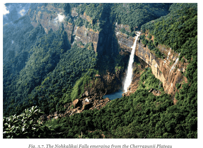
From which plateau and at what height does Nohkalikai Falls drop?
Quick recap
- A plateau is an elevated landform with a more or less flat surface, often with steep sides.
- The Tibetan Plateau is the world’s largest and highest plateau; its average altitude is 4,500 m.
- The Deccan Plateau is one of the oldest plateaus and formed through volcanic activity millions of years ago.
- Plateaus are often mineral-rich and important for mining.
- Rocky plateau soils are often less fertile, while lava plateaus often have rich black soil.
- Examples of plateau waterfalls include Victoria, Hundru, Jog and Nohkalikai Falls.
Plains
What Are Plains?
- Plains: Extensive areas of flat or gently undulating land, generally without large hills or deep valleys.
- Elevation: Plains are generally not more than 300 metres above sea level.
Floodplains and Fertile Soil
Life in the Plains
| Crop type | Examples |
|---|---|
| Food crops | Rice, wheat, maize, barley and millets |
| Fibre crops | Cotton, jute and hemp |
| Point | Rainfed agriculture | Irrigated agriculture |
|---|---|---|
| Water supply | Fields are watered mainly by rainfall. | Water is brought through canals or pumped from groundwater. |
| Change and impact | Traditional form of farming in the region. | Increased production, but irrigation has also contributed to groundwater depletion. |
Irrigation and Groundwater Depletion
- Irrigation supplies water to fields through canals or groundwater pumping.
- The growth of irrigation has increased agricultural production.
- Irrigation has also contributed to groundwater depletion, creating a challenge for future agriculture.
Other Features of Life in the Ganga Plains
- Challenges: High population and pollution also affect the Ganga plains.
- Cultural importance: Many communities regard river sources and confluences as sacred; festivals, ceremonies and rituals take place at such locations.
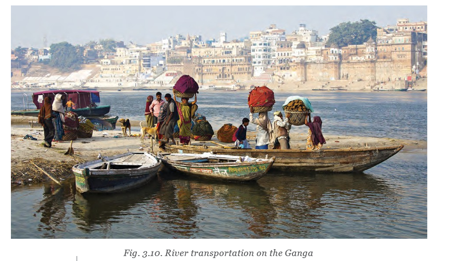
- Transport: The gentle slope of plains makes river navigation easier and supports economic activity.
- Past and present travel: Rivers were widely used for travel in earlier times; boats are still used on some stretches of the Ganga.
Confluence — The meeting point of two or more rivers.
Deserts: Another Landform
- Deserts: Large, dry expanses that receive very little precipitation and have distinctive plants and animals.
- Types: Deserts may be hot, like the Sahara and Thar, or cold, like the Gobi; people have adapted to their harsh conditions.
Landscapes in Ancient Tamil Sangam Poetry
| Tiṇai | Landscape | Main occupation |
|---|---|---|
| Kuriñji | Mountainous regions | Hunting and gathering |
| Mullai | Grasslands and forests | Cattle rearing |
| Marudam | Fertile agricultural plains | Farming |
| Neydal | Coastal regions | Fishing and seafaring |
| Pālai | Arid, desert-like regions | Journeying and fighting |
Landforms and Human Life
How do river sediments make floodplains suitable for agriculture?
How has irrigation affected farming in the Ganga plain?
- Sediments
- Rock particles, sand and silt carried and deposited by rivers.
- Rainfed agriculture
- Farming in which crops receive water mainly from rainfall.
- Irrigation
- Supplying water to fields through canals or groundwater.
- Confluence
- The meeting point of two or more rivers.
Quick recap
- Plains are broad, flat or gently undulating areas, generally no more than metres above sea level.
- River-deposited sediments make floodplain soils fertile; agriculture is a major occupation in plains.
- The Ganga plain supports a large population and farming, fishing and river transport.
- Irrigation increases crop production but has contributed to groundwater depletion; high population and pollution are other challenges.
- Deserts may be hot or cold and have unique flora and fauna; people have adapted to their harsh conditions.
- The five Tamil tiṇais connect different landscapes with occupations and culture.
Social Science — ALL CHAPTERS
1
LOCATING PLACES ON THE EARTH
2
Oceans and Continents
3
LANDFORMS AND LIFE
4
TIMELINE AND SOURCES OF HISTORY
5
INDIA, THAT IS BHARAT
6
THE BEGINNINGS OF INDIAN CIVILISATION
7
INDIA’S CULTURAL ROOTS
8
UNITY IN DIVERSITY, OR MANY IN THE ONE
9
FAMILY AND COMMUNITY
10
GRASSROOTS DEMOCRACY – PART 1 GOVERNANCE
11
GRASSROOTS DEMOCRACY – PART 2 LOCAL GOVERNMENT IN RURAL AREAS
12
GRASSROOTS DEMOCRACY – PART 3 LOCAL GOVERNMENT IN URBAN AREAS
13
THE VALUE OF WORK
14
ECONOMIC ACTIVITIES AROUND US