Class 6 . Social Science . Exploring Society India And Beyond . Locating Places on the Earth
Chapter 1: LOCATING PLACES ON THE EARTH
Ch 1
Social Science
Class 6
Why Social Science?
Social Science: Purpose and Scope
Social Science — The study of human societies and the world they live in, helping us understand the present and work towards a better future.
Why study it?
- Humanity’s challenges: The 21st century brings rapid technological change alongside wars, armed conflicts, social tensions and pressure on the natural environment.
- Shared questions: Social Science explores how societies can live peacefully, solve problems and protect Earth for people and other species.
- Complexity: Societies are diverse, so answers to social problems are rarely simple or fixed.
- Purpose: Understanding people and society helps us make sense of the world and prepare for a better future.
| Point | Social Science | Natural sciences |
|---|---|---|
| Main focus | Human society, which is diverse and complex | The natural world |
| Methods and results | Uses scientific methods where possible, but cannot always rely on fixed procedures and results | Often uses set procedures to reach consistent results |
Major subdisciplines
- Examples: Geography, history, political science, economics, sociology, anthropology, archaeology and psychology.
- Middle Stage: These subjects are introduced through broad themes rather than being studied as a formal list of separate disciplines.
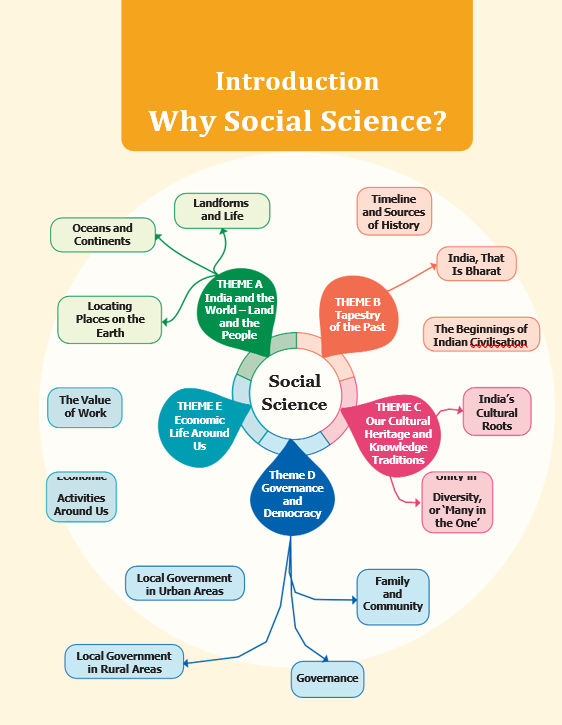
Five Broad Themes
| Theme | Main focus | Why it matters |
|---|---|---|
| A – India and the World: Land and the People | Earth’s main features and representing places on maps; the influence of oceans, mountains and rivers on civilisations. | Shows how geography shapes people, history and India’s distinctive identity. |
| B – Tapestry of the Past | India’s past and its connections to the present. | The past shapes identity and can help people learn from past mistakes. |
| C – Our Cultural Heritage and Knowledge Traditions | The characteristics, principles and historical expressions of Indian culture. | Helps students understand and value cultural foundations and consider their relevance today. |
| D – Governance and Democracy | India’s political system, government at different levels, citizen participation, rights and duties; also other systems and relations between countries. | Encourages responsible citizenship and informed participation in policies. |
| E – Economic Life Around Us | Essentials such as food, clothing, shelter and access to water; livelihoods for adults, education for young people, money, economic activities, and management of natural and human resources. | Introduces ideas needed to understand how economies work and how countries can develop harmoniously. |
Asking Questions and Connecting Subjects
- Good questions: Social Science begins by asking meaningful questions about people, places, society and their relationships.
- Multidisciplinarity: Combining ideas from different fields gives a richer understanding of real life, where many aspects are connected.
- Examples: A geography topic may include chess or ancient Tamil poetry; cultural heritage may discuss the sari; economics may include sevā or festivals.
- Overall direction: Social Science studies the past, makes sense of the present and helps people prepare for a better future.
How Social Science supports a better future
- Ask important questions about society and the world
- Understand people, places and the past
- Make sense of present issues
- Use that understanding to help shape a better future
- Subdiscipline
- A specialised branch within a broader subject.
- Multidisciplinarity
- Bringing knowledge from different subjects together to understand a topic.
- Governance
- The way a country or community is managed and decisions are made.
- Livelihood
- The work and resources people rely on to meet their needs.
Why is Social Science different from subjects such as physics or chemistry?
How does studying the past help us?
Quick recap
- Social Science studies human societies and helps us understand the world.
- It addresses complex challenges such as conflict, social tension and environmental stress.
- It uses scientific methods where possible, but society does not always allow fixed results.
- Its five Middle Stage themes cover geography, the past, culture, governance and economic life.
- Economic life includes basic essentials, livelihoods, education, and the management of resources.
- Social Science develops through meaningful questions and connections across subjects, using the past to understand the present and prepare for a better future.
Introduction & a Map and Its Components
Maps and Atlases
Atlas — An atlas is a book or collection of maps.
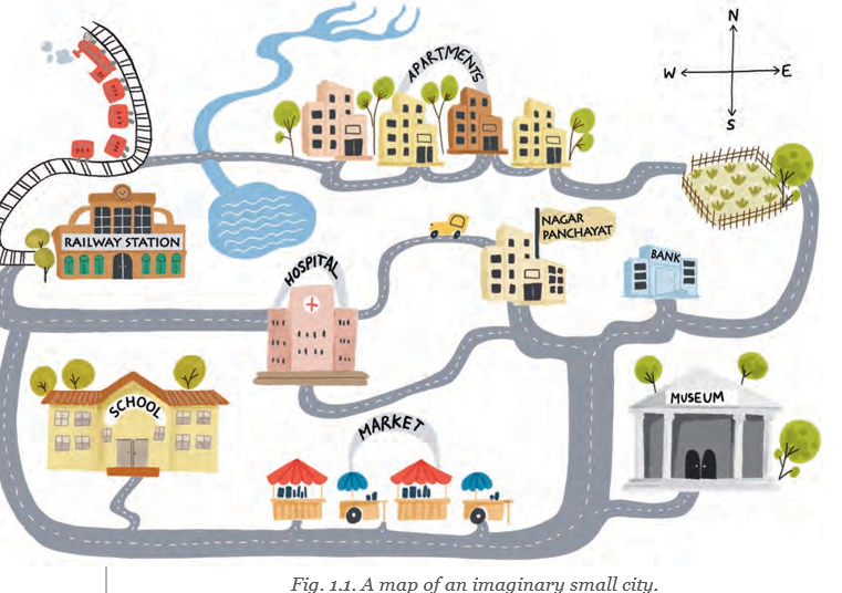
Types of Maps
- Physical maps: Show natural features such as mountains, oceans and rivers.
- Political maps: Show countries or states, boundaries, cities and capitals.
- Thematic maps: Present a specific kind of information.
Distance and Scale
Multiply map distance by the ground distance represented by each map unit to find ground distance .
Scale example
- Playground: A rectangle measuring 40 m by 30 m is drawn as 4 cm by 3 cm at a scale of .
- Diagonal: The drawn diagonal is 5 cm, so the real diagonal is 50 m.
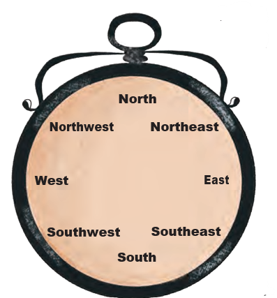
Direction
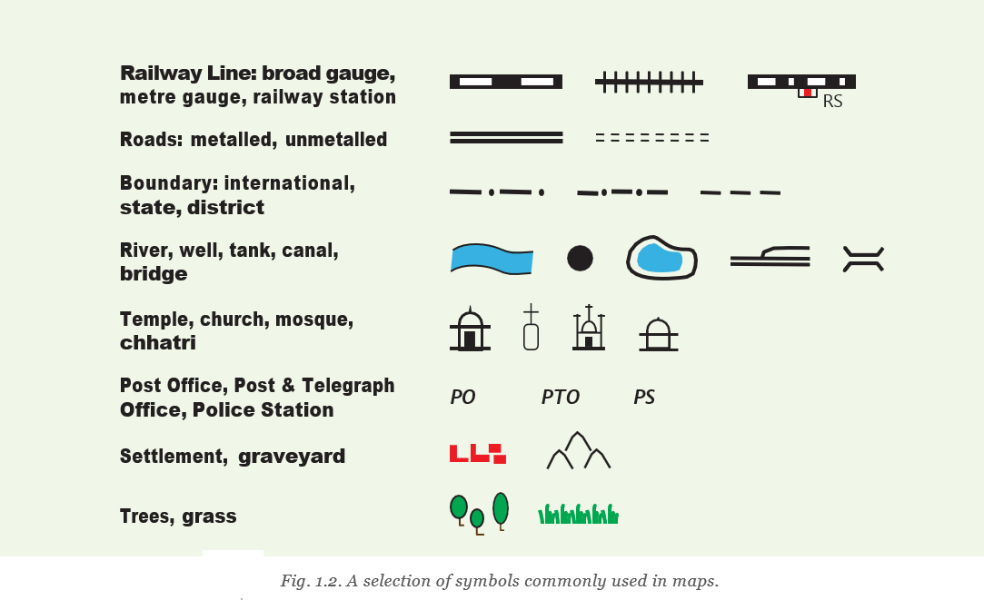
Symbols
- Map
- A top-view representation of an area.
- Atlas
- A book or collection of maps.
- Scale
- The relationship between map distance and ground distance.
- Cardinal directions
- The four main directions: north, east, south and west.
- Symbol
- A sign that represents a feature on a map.
What are the three main components of a map?
Differentiate between physical, political and thematic maps.
Quick recap
- A map represents an area from a top view; an atlas is a collection of maps.
- Physical, political and thematic maps show natural features, political details and specific themes respectively.
- Scale links map distance to ground distance, so actual distance depends on the scale.
- North, east, south and west are cardinal directions; NE, SE, SW and NW are intermediate directions.
- Symbols represent features such as roads, buildings, water and vegetation.
- The Survey of India has set symbols for maps of India.
Mapping the Earth
The Earth and the Globe
- Earth’s shape: The Earth is nearly spherical, slightly flattened at the poles.
- Globe: A sphere with a map drawn on it; it represents Earth’s geography more accurately than a flat map.
Understanding Coordinates
- Coordinates: A system using two values to identify a precise location.
- Examples: Rows and shop numbers in a market, or letters and numbers on a chessboard, help pinpoint a place or square.
Latitudes
Latitude and Climate
- Near the Equator, low latitude → generally hot or torrid climate.
- Moving away from the Equator, increasing latitude → generally more moderate or temperate climate.
- Near the North or South Pole, very high latitude → cold or frigid climate.
- Globe
- A spherical model bearing a map of the Earth or another space object.
- Coordinates
- References that specify the precise location of a place or square.
- Latitude
- Angular distance north or south of the Equator, measured in degrees.
- Equator
- The largest parallel of latitude, halfway between the poles and marked 0°.
- Parallels of latitude
- Imaginary east–west circles parallel to the Equator.
What are parallels of latitude?
How is latitude related to climate?
Quick recap
- The Earth is nearly spherical, so a globe represents its geography more accurately than a flat map.
- Coordinates use references to locate places precisely; chessboard squares are identified by a letter and a number.
- Latitude measures distance north or south of the Equator in degrees.
- The Equator is 0°; the North and South Poles are 90°N and 90°S.
- Parallels of latitude run east–west and become smaller towards the poles.
- Climate is generally torrid near the Equator, temperate farther away, and frigid near the poles.
Longitudes
Meridians of Longitude
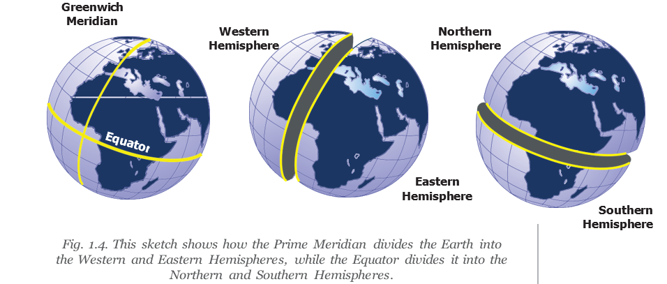
- Meridians: Imaginary half-circles that run from the North Pole to the South Pole.
- Prime Meridian: The meridian through Greenwich, London, was chosen as the international reference in 1884 and is marked 0° longitude.
- Longitude: Measured east or west from the Prime Meridian in degrees, up to 180°.
Longitude and Time
Why longitude relates to time
- Earth rotates on its axis.
- Different longitudes face the Sun at different times.
- Places at different longitudes therefore experience different times of day.
The Prime Meridian and Measuring Longitude
| Point | Latitude | Longitude |
|---|---|---|
| Reference line | Equator | Prime Meridian |
| Measured by travelling | From the Equator towards a pole | From the Prime Meridian along the Equator |
| Direction labels | North or South | East or West |
Do not write and as different longitudes: they refer to the same longitude, written simply as .
Examples of Longitude
- New York: approximately .
- Delhi: approximately .
- Tokyo: approximately .
Coordinates and the Globe Grid
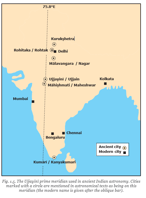
The Ujjayini Meridian
- Meridian
- A half-circle joining the North Pole and South Pole.
- Prime Meridian
- The reference meridian at longitude.
- Longitude
- A place’s east–west position measured in degrees from the Prime Meridian.
- Grid lines
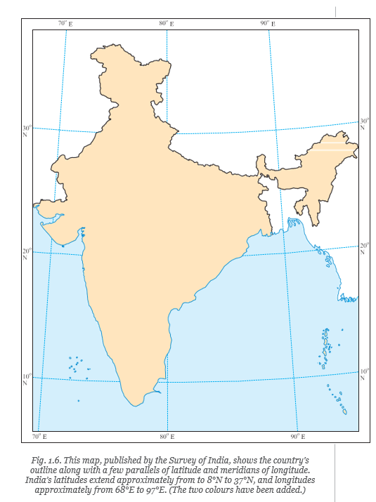
- The combined parallels of latitude and meridians of longitude on a globe.
- Madhya rekhā
- The ancient Indian prime meridian passing through Ujjayinī.
What is the Prime Meridian, and how is longitude measured?
How do latitude and longitude help locate a place?
Quick recap
- Meridians are half-circles running from pole to pole.
- The Greenwich Meridian is the international Prime Meridian at longitude, agreed upon in 1884.
- Longitude is measured east or west from the Prime Meridian, up to .
- and identify the same longitude.
- Latitude and longitude together locate places and form the globe’s grid.
- The ancient Indian madhya rekhā passed through Ujjayinī and was used in astronomical calculations.
Understanding Time Zones
Longitude and Local Time
Local time — The time at a place based on the Sun’s position there; it changes with longitude.
How longitude affects local time
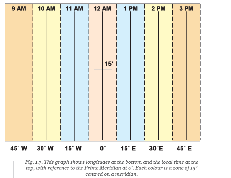
- Earth’s rotation: Earth spins from west to east, completing one full turn of in 24 hours.
- Time change: Earth rotates per hour, so each of longitude corresponds to a one-hour time difference.
- Eastward: Local time moves ahead by one hour for each east of the Prime Meridian.
- Westward: Local time moves back by one hour for each west of the Prime Meridian.
- Example: When it is noon at Greenwich, local time is 1 p.m. at and 11 a.m. at .
Porbandar and Tinsukia example
- Longitude difference: Tinsukia is east of Porbandar; using the approximate difference of , Tinsukia’s local time is about two hours ahead.
- Different daylight: The Sun’s apparent position and sunset time vary with longitude, so it can be dark in Assam while daylight remains in Gujarat.
Standard Time and Time Zones
Standard time — A common time adopted for a country or region, based on a selected meridian, instead of using many local times.
Local time vs standard time
- Local time: Varies from place to place according to longitude.
- Standard time: A shared time used across a country or region for convenience.
- India: Indian Standard Time (IST) is 5 hours 30 minutes, or hours, ahead of Greenwich Mean Time (GMT).
- Gujarat and Assam: Their local times differ because of longitude, but both use IST as the country’s standard time.
| Point | Local time | Standard time |
|---|---|---|
| Basis | Longitude and the Sun’s position at a place | A selected meridian for a country or region |
| Use | Can differ between places in one country | Provides a common time for the country or region |
| India example | Porbandar and Tinsukia have different local times | Both use IST |
Time zone — A region that follows a particular standard time, broadly based on zones of longitude.
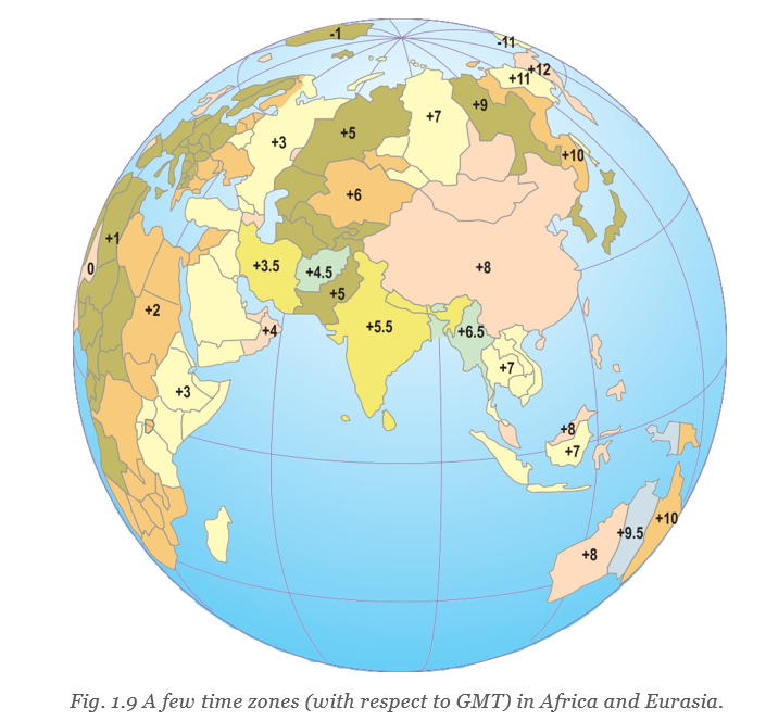
Time-zone boundaries
- Shape: Time zones broadly follow longitude bands, but their boundaries are often irregular rather than straight.
- Reason: Boundaries are adjusted to respect countries’ standard times and international borders.
- GMT offsets: A positive number means add that many hours to GMT; a negative number means subtract that many hours.
- Large countries: Some countries use several time zones; the USA has six and Russia has 11.
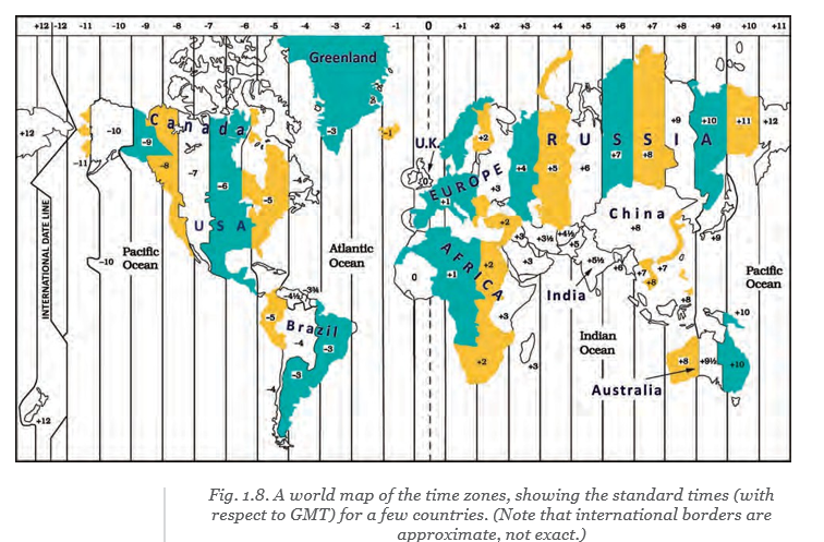
Multiple time zones
- Why needed: Countries that stretch across a large area may need several time zones.
- Russia: It has 11 time zones, so travelling across it from east to west requires 10 watch adjustments.
The International Date Line
International Date Line (IDL) — An imaginary line near longitude, opposite the Prime Meridian, where crossing changes the calendar date by one day.
Crossing the IDL
- Time zones: The and time zones meet near the IDL.
- Travelling eastward: Subtract one day from the date; for example, Monday becomes Sunday.
- Travelling westward: Add one day to the date; for example, Sunday becomes Monday.
- Irregular path: The IDL deviates from in places to avoid splitting countries into two different dates.
Maps and the Geographic Grid
Locating places
- Maps: Maps represent areas of the Earth; their main components are distance, direction and symbols.
- Geographic grid: Latitudes and longitudes form an imaginary grid that helps define the precise location of any place.
- Latitudes: Imaginary lines running east–west, parallel to the Equator.
- Longitudes: Imaginary lines running north–south from pole to pole; they also help determine local time and time zones.
- Longitude
- Imaginary lines running north to south that help locate places and determine local time.
- Local time
- Time at a place based on the Sun’s position there.
- Standard time
- A common time based on a selected meridian and used across a region.
- Greenwich Mean Time (GMT)
- The time at Greenwich used as a reference for time-zone offsets.
- International Date Line (IDL)
- A line near longitude where crossing changes the date by one day.
Why does local time change with longitude?
How does the date change when crossing the International Date Line?
Quick recap
- Earth rotates in 24 hours, or per hour.
- Local time moves ahead to the east and back to the west.
- Standard time gives a region a shared time based on a selected meridian.
- Time-zone boundaries often bend to respect international borders.
- Large countries such as Russia and the USA use multiple time zones.
- The IDL lies near longitude; crossing it east subtracts a day and crossing west adds a day.
- Latitudes run east–west and longitudes run north–south; together they form a grid that precisely locates places.
Social Science — ALL CHAPTERS
1
LOCATING PLACES ON THE EARTH
2
Oceans and Continents
3
LANDFORMS AND LIFE
4
TIMELINE AND SOURCES OF HISTORY
5
INDIA, THAT IS BHARAT
6
THE BEGINNINGS OF INDIAN CIVILISATION
7
INDIA’S CULTURAL ROOTS
8
UNITY IN DIVERSITY, OR MANY IN THE ONE
9
FAMILY AND COMMUNITY
10
GRASSROOTS DEMOCRACY – PART 1 GOVERNANCE
11
GRASSROOTS DEMOCRACY – PART 2 LOCAL GOVERNMENT IN RURAL AREAS
12
GRASSROOTS DEMOCRACY – PART 3 LOCAL GOVERNMENT IN URBAN AREAS
13
THE VALUE OF WORK
14
ECONOMIC ACTIVITIES AROUND US