Class 6 . Social Science . Exploring Society India And Beyond . The Beginnings of Indian Civilisation
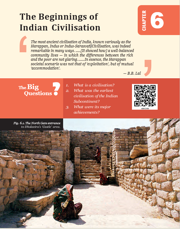
Chapter 6: THE BEGINNINGS OF INDIAN CIVILISATION
Ch 6
Social Science
Class 6
Introduction & What Is a Civilisation?
Metallurgy — The techniques and study involved in extracting, purifying and combining metals, and understanding their properties.
The First Civilisations
- Different beginnings: Civilisation developed at different times in different parts of the world.
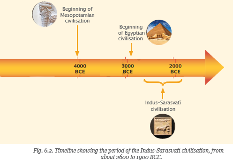
- Mesopotamia: The civilisation in the region of modern Iraq and Syria began about 6,000 years ago.
- Ancient Egypt: Its civilisation followed Mesopotamia a few centuries later.
- Importance: Ancient civilisations made major contributions and advances that helped shape human societies.
From Village to City
Tributary — A river or stream that flows into a larger river or lake; for example, the Yamuna flows into the Ganga.
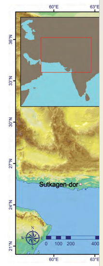
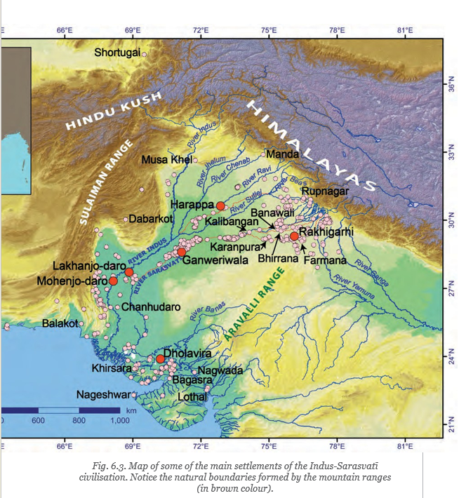
- Fertile plains: The Punjab (now divided between India and Pakistan) and Sindh (now in Pakistan) are watered by the Indus and its tributaries, making them favourable for agriculture.
- Sarasvati River: A river once flowed from the Himalayan foothills through Haryana, Punjab, parts of Rajasthan and Gujarat.
- Growth of settlements: From about 3500 BCE, villages in this region grew into towns; increasing trade and exchanges helped towns develop into cities around 2600 BCE.
- Names: Archaeologists use Indus, Harappan, Indus-Sarasvati and Sindhu-Sarasvati for this civilisation; its inhabitants are called Harappans.
- Significance: It is one of the world’s oldest civilisations. Its growth into cities is also called the First Urbanisation of India.
From Fertile Villages to Cities
- Indus, tributaries and Sarasvati water the region → fertile land supports agriculture
- Agriculture supports growing villages → villages develop into towns
- Trade and other exchanges increase → towns grow into cities around 2600 BCE
Why the Name “Harappan”?
- Harappa: The city of Harappa, in present-day Punjab, Pakistan, was the first site of this civilisation to be excavated.
- Excavation: Harappa was excavated in 1920–21; the civilisation’s inhabitants came to be called Harappans.
| Harappan city | Modern state or region |
|---|---|
| Dholavira | Gujarat |
| Harappa | Punjab, Pakistan |
| Kalibangan | Rajasthan |
| Mohenjo-daro | Sindh, Pakistan |
| Rakhigarhi | Haryana |
The Sarasvati River
- Indus and tributaries: Important cities such as Harappa and Mohenjo-daro grew along the Indus river system.
- Modern names: The Sarasvati is associated with the Ghaggar in India and the Hakra in Pakistan; together, the river is called the Ghaggar-Hakra.
- Present condition: The Ghaggar-Hakra is now seasonal and flows only during the rainy season.
- Ṛig Veda: This ancient collection of prayers first mentions Sarasvati, worshipped both as a goddess and as a river flowing “from the mountain to the sea.”
- Later accounts: Later texts describe the river drying up and eventually disappearing.
Key Dates and Periods
- About 6,000 years agoCivilisation began in Mesopotamia, in the region of modern Iraq and Syria.
- A few centuries laterAncient Egyptian civilisation followed.
- About 3500 BCEVillages in the Indus-Sarasvati region began growing into towns.
- Around 2600 BCEThe towns developed into cities, marking the First Urbanisation of India.
- 1920–21Harappa, the first site of this civilisation to be excavated, was excavated.
What features are used here to identify a civilisation?
Why are the people of the Indus-Sarasvati civilisation called Harappans?
Quick recap
- A civilisation is an advanced society with organised government, cities, crafts, trade, writing, cultural life and productive agriculture.
- Civilisations began at different times; Mesopotamia preceded ancient Egypt by a few centuries.
- The Indus-Sarasvati region’s fertile river plains supported agriculture and growing settlements.
- Villages developed into towns from about 3500 BCE; cities emerged around 2600 BCE in India’s First Urbanisation.
- The civilisation is also called Indus, Harappan, Indus-Sarasvati or Sindhu-Sarasvati; its people are called Harappans.
- The Sarasvati is associated with the seasonal Ghaggar-Hakra river and is mentioned in the Ṛig Veda.
Town-planning
Cities and the Extent of the Civilisation
Discovery
- 1924The identification of Harappa and Mohenjo-daro as cities of this civilisation goes back to this year.
| Site or group | Location / significance |
|---|---|
| Harappa and Mohenjo-daro | In present-day Pakistan; the first two cities of the civilisation to be discovered. |
| Dholavira | Gujarat. |
| Rakhigarhi | Haryana; a major city in the Sarasvatī basin. |
| Ganweriwala | Cholistan desert of Pakistan; a major city in the Sarasvatī basin. |
| Lothal | Gujarat; one of the smaller sites. |
| Farmana and Kalibangan | Smaller sites in the Sarasvatī basin, in Haryana and Rajasthan respectively. |
| Bhirrana and Banawali | Towns in Haryana, in the Sarasvatī basin. |
Why the Name ‘Indus Valley’ Is Outdated
- Early name: The civilisation was first called the Indus Valley civilisation because several early-known sites lay in the Indus plains.
- Wider extent: Later discoveries showed that its settlements spread far beyond the Indus region, including a dense cluster in the Sarasvatī basin.
- Today: Discoveries of sites continue; the name ‘Indus Valley civilisation’ does not describe its full extent.
Planned City Layout
City Plan and Buildings
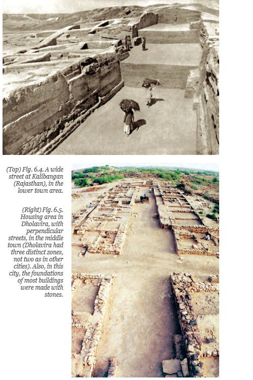
- Planned streets: Larger cities followed precise plans, with wide streets often aligned to the cardinal directions.
- Fortifications: Many cities seem to have been enclosed by massive protective walls.
- Two parts: The upper town was probably associated with the local elite; the lower town was where common people lived.
- Buildings: Large structures may have served collective purposes, such as storing goods for transport. Houses of different sizes lined streets and lanes.
- Construction: Small and large houses were generally built of bricks, with similar construction quality.
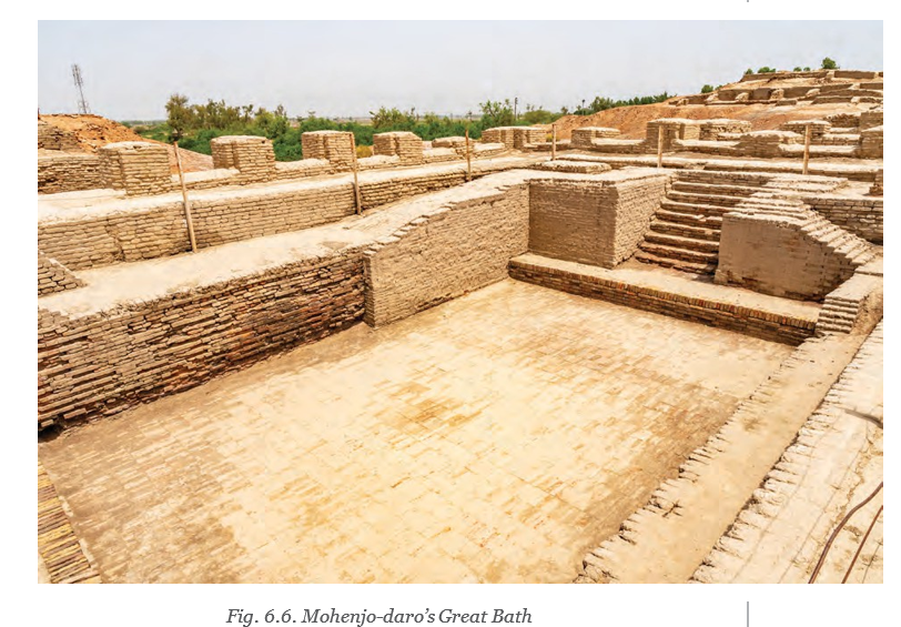
The Great Bath at Mohenjo-daro
Structure and Possible Uses
- Size and construction: The tank measured about metres. Carefully laid bricks were waterproofed with materials such as natural bitumen.
- Features: Small rooms surrounded the tank; one contained a well. A drain at one corner allowed it to be emptied and refilled with fresh water.
- Possible uses: It may have been a bath for the royal family or a tank for religious rituals; its exact purpose remains debated.
- Ruled-out idea: It is unlikely to have been a public bath for everyone, since most houses in Mohenjo-daro had their own bathrooms.
- Evidence limit: No inscription, written text or traveller’s account explains the structure, so its purpose cannot be confirmed.
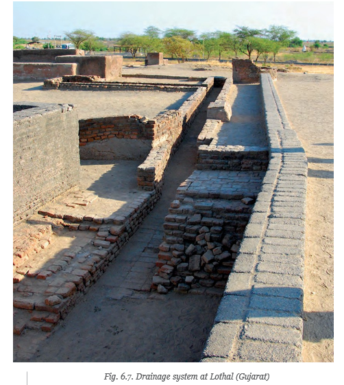
Water Management and Cleanliness
Household Drainage Network
- Separate bathing areas in homes
- → Connected to a wider drainage network
- → Drains generally ran below streets
- → Wastewater was carried away
| Place / feature | Water source or detail |
|---|---|
| Mohenjo-daro | People drew water from hundreds of brick-built wells. |
| Other regions | Water may have come from ponds, nearby streams or human-made reservoirs. |
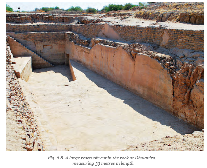
| Dholavira | At least six large reservoirs were built with stone or cut into rock; the largest was 73 metres long. |
Dholavira’s Reservoir System
- Construction: Reservoirs were built from stone or cut into the rock.
- Connection: Most were linked by underground drains.
- Purpose: The connected system supported efficient water harvesting, storage and distribution.
- Organisation: Building and maintaining such a network required coordinated labour and instructions, suggesting organised local administration; the exact arrangements are uncertain.
- Fortification
- A massive wall around a settlement or city, generally built for protection.
- Elite
- The higher social layers, such as rulers, officials, administrators and often priests.
- Reservoir
- A large natural or artificial place where water is stored.
- Upper town and lower town
- The two distinct parts found in many cities; the upper town was probably linked to the elite, and the lower town to common people.
What does the Great Bath’s construction tell us, and why is its exact purpose uncertain?
Quick recap
- The civilisation spread beyond the Indus region, making ‘Indus Valley civilisation’ an outdated name.
- Many cities had planned streets, fortifications and upper and lower sections.
- Houses of different sizes were generally brick-built and had similar construction quality.
- The Great Bath was waterproofed and carefully designed, but its use remains uncertain.
- Household bathing areas connected to covered street drains carried wastewater away.
- Wells and connected reservoirs supplied and managed water; Dholavira’s largest reservoir was 73 metres long.
What Did the Harappans Eat?
Food and Agriculture
Farming and food
- Rivers and settlements: Many Harappan settlements were near rivers, which provided water and enriched the soil for farming.
- Crops: Harappans grew barley, wheat, some millets, sometimes rice, pulses and a variety of vegetables.
- Cotton: They were the first people in Eurasia to grow cotton, which they used to make cloth.
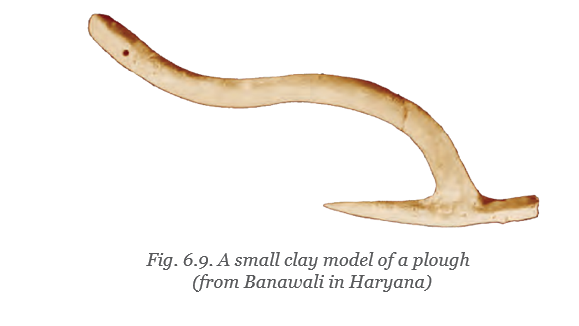
- Tools: They made farming tools, including the plough; some ploughs resemble tools still used by farmers.
- Rural support: Hundreds of small villages managed agricultural production. Cities depended on a regular supply of food from the countryside.
Pulses — Crops such as beans, peas and lentils.
Other sources of food
- Meat and fish: Harappans domesticated animals for meat and fished in rivers and the sea.
- Evidence: Excavations have uncovered large numbers of animal and fish bones.
- Cooking pots: Scientific examination found traces of dairy products, turmeric, ginger and banana, showing that the diet was varied.
A Brisk Trade
Trade goods and craftwork
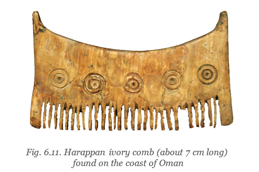
- Trade links: Harappans traded with settlements within their civilisation and with other cultures inside and outside India.
- Exports: They sent out ornaments, timber and some everyday objects; gold, cotton and food items may also have been exported.
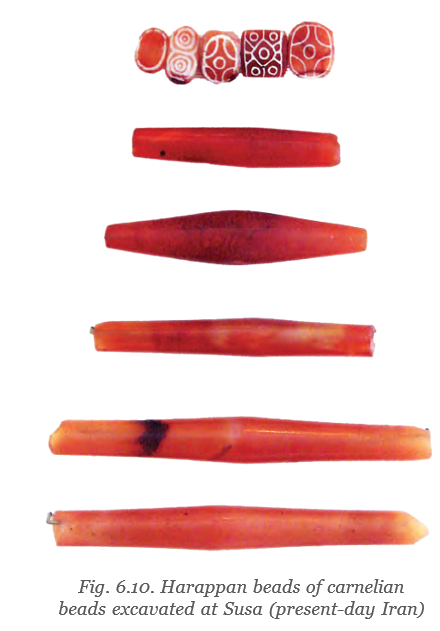
- Carnelian beads: These reddish semiprecious stones were especially popular and were found mainly in Gujarat. Craftspeople drilled and decorated them using specialised techniques.
- Shell bangles: Craftspeople shaped hard conch shells into bangles using skilled techniques.
Imports and metals
- Imports: The goods received in exchange are uncertain; copper was probably imported because it was not common in the Harappan region.
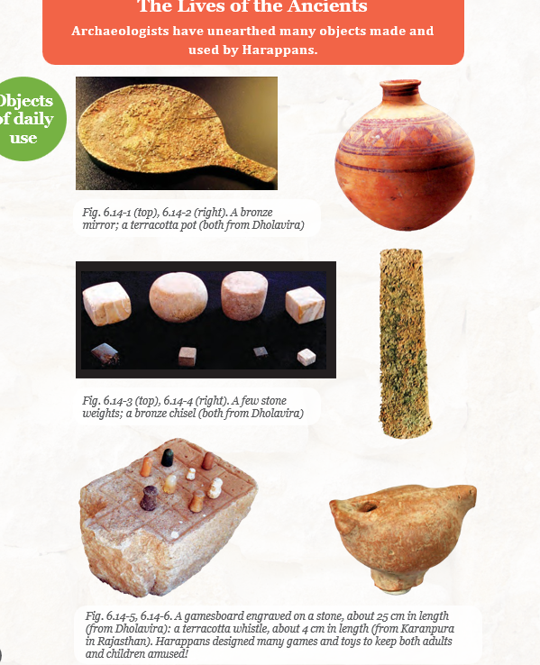
- Copper: Harappans were skilled at working this relatively soft metal.
- Bronze: Adding tin to copper makes bronze, a harder metal. Harappans used bronze for tools, pots and pans, and figurines.
Harappan trade routes
- Land routes and rivers linked settlements.
- Sea routes carried goods to more distant destinations.
- This was the earliest intensive maritime activity in India.
Lothal and maritime trade
- Coastal settlements: Several Harappan settlements were in the coastal regions of Gujarat and Sindh.
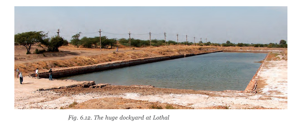
- Lothal: This Gujarat settlement had a large basin measuring m by m.
- Dockyard: The basin is thought to have been a dockyard—a place for receiving and sending boats carrying goods.
Seals and trade identification
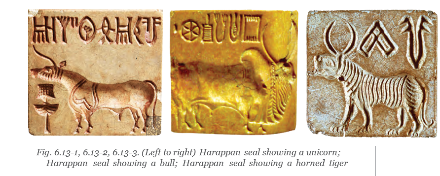
- Purpose: Thousands of small seals found at Harappan settlements seem to have helped traders identify goods and one another.
- Material and size: Seals were generally made of steatite, a soft stone hardened by heating, and were only a few centimetres long.
- Design: They commonly showed an animal with a few signs from a writing system above it.
- What remains unknown: The writing system and the symbolic meanings of the animals have not been understood; the seals are known to be connected with trade.
- Carnelian
- A reddish semiprecious stone used to make popular Harappan beads.
- Steatite
- A soft stone commonly used to make Harappan seals; heating hardened it.
- Dockyard
- A structure used to receive and send boats.
- Bronze
- A harder metal made by adding tin to copper.
What evidence shows that the Harappan diet was varied?
Describe two important features of Harappan trade.
Why is Lothal important in the study of Harappan trade?
Quick recap
- Harappans grew a variety of crops, including cereals, pulses, vegetables and cotton.
- Animal bones, fish bones and traces in cooking pots reveal a varied diet.
- Villages supplied agricultural produce that helped cities survive.
- Harappan trade involved local and distant partners, specialised crafts and several transport routes.
- Lothal’s basin is thought to have served as a dockyard.
- Seals were linked with trade, but their signs and animal symbols remain undeciphered.
The End or a New Beginning?
Decline of the Harappan Cities
Decline of the Harappan civilisation — From around 1900 BCE, Harappan cities were gradually abandoned and urban administration appears to have disappeared.
Changes in Settlement
- Cities were abandoned one by one; any inhabitants who remained adopted a rural lifestyle.
- Administration appears to have ceased, and Harappans spread across hundreds or thousands of small rural settlements.
- Rural living offered easier access to food and water; cities had depended on villages for these supplies.
Environmental Change and Decline
- From 2200 BCE onwardReduced rainfall brought a drier phase to much of the world.
- Around 1900 BCEHarappan cities began to fall apart and were abandoned.
Possible Causes of Decline
| Proposal | Evidence and assessment |
|---|---|
| Warfare or invasion | No traces of warfare or invasion have been found; evidence suggests the Harappans had no army or weapons of war and lived relatively peacefully. |
| Climatic change | Reduced rainfall made agriculture more difficult and may have lowered food supplies to cities. |
| Sarasvatī River drying | The river dried up in its central basin; cities there, including Kalibangan and Banawali, were abandoned. |
How Environmental Change Could Lead to City Abandonment
- Reduced rainfall → drier conditions
- Drier conditions → agriculture became more difficult
- Harder farming → food supplies to cities may have declined
- Environmental pressures and river drying → people left cities for rural settlements
What Continued After the Cities?
Cultural Continuity
- Survival: Although the cities disappeared, much of Harappan culture and technology continued.
- Legacy: Harappan traditions and technologies were passed on to the next phase of Indian civilisation.
- Lesson: Human well-being depends greatly on climate and the environment.
Key Features of the Harappan Civilisation
Achievements and Economy
- Importance: The Indus, Harappan or Sindhu-Sarasvatī civilisation is one of the oldest civilisations in the world.
- Cities: Harappans built planned cities with efficient water management.
- Economy: Diverse crafts, brisk trade and productive agriculture supported urban life.
- Crops: Productive farming supplied a variety of crops to the cities.
- Harappans
- The people of the Indus, Harappan or Sindhu-Sarasvatī civilisation.
- Central basin
- The middle region of the Sarasvatī River basin that dried up.
- Rural settlement
- A small settlement outside a city where people lived a rural lifestyle.
What are the two main factors linked to the decline of Harappan cities?
Why is warfare or invasion not a supported explanation for the decline?
Quick recap
- The Indus, Harappan or Sindhu-Sarasvatī civilisation was one of the world’s oldest, known for planned cities, water management, crafts, trade and productive agriculture.
- Harappan cities began to be abandoned around 1900 BCE, and people spread into small rural settlements.
- Rural life offered easier access to food and water, which cities had obtained from villages.
- Reduced rainfall from 2200 BCE onward made agriculture harder and may have reduced food supplies to cities.
- The drying of the Sarasvatī River’s central basin was linked to the abandonment of Kalibangan and Banawali.
- Warfare or invasion is not supported by the available evidence.
- Harappan culture and technology survived and were passed on to the next phase of Indian civilisation.
Social Science — ALL CHAPTERS
1
LOCATING PLACES ON THE EARTH
2
Oceans and Continents
3
LANDFORMS AND LIFE
4
TIMELINE AND SOURCES OF HISTORY
5
INDIA, THAT IS BHARAT
6
THE BEGINNINGS OF INDIAN CIVILISATION
7
INDIA’S CULTURAL ROOTS
8
UNITY IN DIVERSITY, OR MANY IN THE ONE
9
FAMILY AND COMMUNITY
10
GRASSROOTS DEMOCRACY – PART 1 GOVERNANCE
11
GRASSROOTS DEMOCRACY – PART 2 LOCAL GOVERNMENT IN RURAL AREAS
12
GRASSROOTS DEMOCRACY – PART 3 LOCAL GOVERNMENT IN URBAN AREAS
13
THE VALUE OF WORK
14
ECONOMIC ACTIVITIES AROUND US