Class 11 Humanities . Geography . Fundamental Of Physical Geography . Atmospheric Circulation and Weather Systems
Chapter 9: Atmospheric Circulation And Weather Systems
Ch 9
Geography
Class 11 Humanities
Atmospheric Pressure
Atmospheric Pressure and Wind
Atmospheric pressure — The weight of the air column above a unit area, from mean sea level to the top of the atmosphere.
Pressure and air movement
- Unit and sea-level value: Pressure is measured in millibars (mb); average sea-level pressure is 1,013.2 mb.
- Heating and cooling: Heated air expands; cooled air contracts. Uneven heating therefore creates pressure differences.
- Wind: Air moves horizontally from high-pressure areas towards low-pressure areas; this horizontal movement is wind.
- Vertical movement: Pressure conditions also influence whether air rises or sinks. Rising moist air cools, forms clouds and may produce precipitation.
- Role of wind: Winds redistribute heat and moisture across Earth, helping regulate the planet’s overall temperature.
- Instruments: Atmospheric pressure is measured using a mercury barometer or an aneroid barometer.
Vertical Variation of Pressure
- With height: Pressure decreases rapidly in the lower atmosphere because air becomes less dense higher above Earth’s surface.
- Approximate rate: Pressure falls by about 1 mb for every 10 m increase in elevation, but the rate is not constant.
- Vertical forces: The vertical pressure-gradient force is much stronger than the horizontal one, but gravity nearly balances it in the opposite direction; therefore, strong upward winds are not normally experienced.
| Elevation | Pressure (mb) | Temperature (°C) |
|---|---|---|
| Sea level | 1,013.25 | 15.2 |
| 1 km | 898.76 | 8.7 |
| 5 km | 540.48 | −17.3 |
| 10 km | 265.00 | −49.7 |
Horizontal Distribution of Pressure
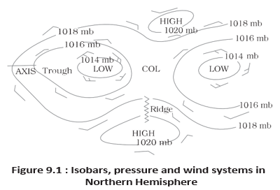
Isobars — Lines on a map joining places with equal atmospheric pressure.
- Why small differences matter: Even slight horizontal pressure differences affect wind direction and speed.
- Sea-level adjustment: Station pressure is reduced to sea level so that differences in altitude do not distort comparisons.
- Weather maps: Sea-level pressure patterns are shown using isobars.
- Low-pressure system: One or more isobars enclose the system, with the lowest pressure at its centre.
- High-pressure system: One or more isobars enclose the system, with the highest pressure at its centre.
World Distribution of Sea-Level Pressure
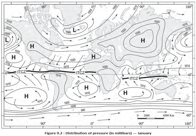
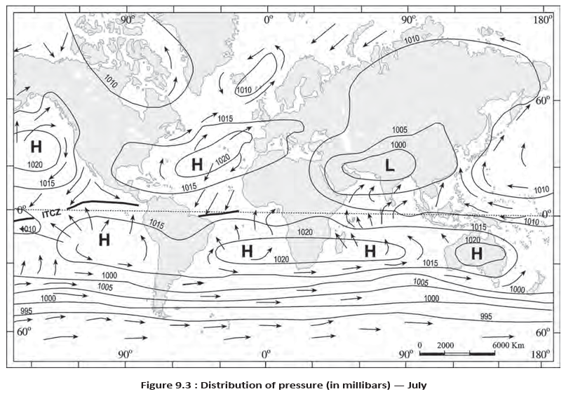
| Approximate latitude | Pressure belt | Pressure |
|---|---|---|
| Equator | Equatorial low | Low |
| 30° N and 30° S | Subtropical highs | High |
| 60° N and 60° S | Subpolar lows | Low |
| Near the poles | Polar highs | High |
- Seasonal movement: These pressure belts are not fixed; they shift with the apparent movement of the Sun.
- Northern Hemisphere: The belts move southward in winter and northward in summer.
- Atmospheric pressure
- Weight of the air column above a unit area.
- Isobar
- A line joining places of equal pressure.
- Equatorial low
- Low-pressure belt near the equator.
- Subtropical high
- High-pressure belt around 30° N and 30° S.
- Subpolar low
- Low-pressure belt around 60° N and 60° S.
- Polar high
- High-pressure area near the poles.
Why is station pressure reduced to sea level when comparing places?
Name the major global pressure belts in order from the equator towards the poles.
Quick recap
- Atmospheric pressure is the weight of the air column above a unit area; average sea-level pressure is about 1,013.2 mb.
- Pressure decreases with height, though the rate of decrease is not constant.
- Air moves from high pressure to low pressure, creating wind.
- Isobars join places of equal pressure; low and high systems have their lowest and highest pressure at the centre, respectively.
- Pressure belts extend from equatorial low to subtropical highs, subpolar lows and polar highs.
- Pressure belts shift with the apparent movement of the Sun; in the Northern Hemisphere they move south in winter and north in summer.
Forces Affecting the Velocity and Direction of Wind
Wind and the Forces Acting on It
- Wind: Air moves from high-pressure areas toward low-pressure areas.
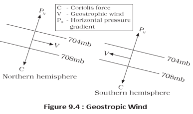
- Forces: Horizontal winds near Earth’s surface are influenced by pressure differences, surface friction and Earth’s rotation.
Pressure Gradient Force
Do not confuse the pressure gradient with the pressure gradient force: the gradient measures pressure change with distance, while the force acts perpendicular to isobars, from high toward low pressure.
Frictional Force
- Friction: Surface friction slows the wind, with the greatest effect near the ground.
- Extent: Its influence generally reaches about 1–3 km above the surface.
- Surface type: Friction is minimal over the sea compared with over land.
Coriolis Force
Pressure and Wind Circulation
| Pressure system | Pressure at centre | Northern Hemisphere | Southern Hemisphere |
|---|---|---|---|
| Cyclone | Low | Anticlockwise | Clockwise |
| Anticyclone | High | Clockwise | Anticlockwise |
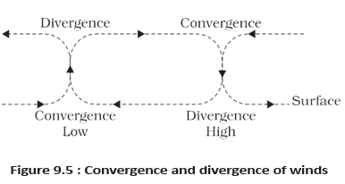
Surface Air Movement and Rising Air
- Low pressure: surface air converges → air rises.
- High pressure: air subsides from above → surface air diverges.
- Other lifting processes: eddies, convection currents, orographic uplift and uplift along fronts also raise air.
- Rising air is essential for cloud formation and precipitation.
What is geostrophic wind?
Why do tropical cyclones not form near the equator?
Quick recap
- Wind flows from high pressure toward low pressure; a stronger pressure gradient generally produces faster wind.
- Pressure gradient force acts perpendicular to isobars; friction slows wind and is strongest near the surface.
- The Coriolis force deflects winds right in the Northern Hemisphere and left in the Southern Hemisphere.
- Coriolis force increases with latitude and wind speed, is strongest at the poles, and is absent at the equator.
- With straight isobars and no friction, balanced pressure gradient and Coriolis forces produce geostrophic wind parallel to isobars.
- Cyclones rotate anticlockwise in the Northern Hemisphere and clockwise in the Southern; anticyclones rotate oppositely.
- Air converges and rises over lows, while it subsides and diverges at the surface around highs.
General Circulation Of The Atmosphere
General Circulation: Meaning and Controls
General circulation of the atmosphere — The global pattern of planetary winds and atmospheric movement is called the general circulation of the atmosphere.
- Controls: Latitudinal differences in atmospheric heating and the resulting pressure belts.
- Seasonal shift: Pressure belts migrate with the apparent movement of the Sun.
- Other controls: Distribution of continents and oceans, and Earth’s rotation.
- Climate link: Atmospheric circulation transfers heat and helps set ocean water in motion.
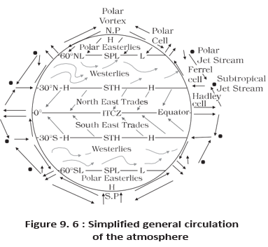
The Three Circulation Cells
Circulation cell — A circulation cell is a loop of air movement from the surface upward and back downward.
Inter Tropical Convergence Zone (ITCZ) — A low-pressure zone near the equator where tropical winds converge and heated air rises.
- ITCZ uplift: Strong insolation heats the air, causing convection and low pressure; winds from the tropics converge there.
- Upper-air flow: Rising air reaches the top of the troposphere, up to about , then moves towards the poles.
- Subtropical sinking: Air accumulates near north and south and sinks, partly because it cools; this helps form subtropical highs.
- Surface return: Air flows from subtropical highs towards the equator as easterlies, which converge again at the ITCZ.
- Heat transfer: The transfer of heat from lower to higher latitudes helps maintain general circulation.
| Cell | Main circulation | Surface winds | Key feature |
|---|---|---|---|
| Hadley cell | Air rises near the ITCZ, moves poleward aloft, and sinks near north and south. | Easterlies flow back towards the equator. | Tropical circulation; sinking air helps form subtropical highs. |
| Ferrel cell | Warm air from subtropical highs rises while cold air from the poles sinks in the middle latitudes. | Westerlies | Middle-latitude circulation. |
| Polar cell | Cold, dense air sinks near the poles and flows towards middle latitudes. | Polar easterlies | Polar circulation. |
Hadley Cell: Surface-to-Upper-Air Cycle
- Strong heating near the equator → air rises at the ITCZ.
- Air flows poleward in the upper troposphere → accumulates and sinks near north and south.
- Surface air moves back towards the equator as easterlies → the easterlies converge at the ITCZ.
Atmospheric Circulation and the Oceans
- Wind-driven currents: Large-scale atmospheric winds initiate large, slow-moving ocean currents.
- Ocean feedback: Oceans supply energy and water vapour to the atmosphere, influencing climate.
- Slow interaction: These exchanges take place slowly over large parts of the oceans.
El Niño, Southern Oscillation and ENSO
El Niño — El Niño is the appearance of warm water off Peru when warm central Pacific water drifts towards the South American coast and replaces the cool Peruvian current.
Southern Oscillation — The pressure changes associated with El Niño between the central Pacific and Australia are called the Southern Oscillation.
ENSO — ENSO is the combined phenomenon of El Niño and the Southern Oscillation.
Effects of Strong ENSO
- Strong ENSO → large-scale weather variations around the world.
- Arid west coast of South America → heavy rainfall.
- Australia and sometimes India → drought.
- China → floods.
- Forecasting: ENSO is monitored closely and used for long-range forecasting in many parts of the world.
- Hadley cell
- Tropical circulation between the ITCZ and subtropical highs.
- Ferrel cell
- Middle-latitude circulation associated with surface westerlies.
- Polar cell
- Circulation in which cold air sinks near the poles and flows towards middle latitudes.
- ENSO
- The combined El Niño and Southern Oscillation phenomenon.
How does the Hadley cell operate?
What is ENSO, and what are some effects of a strong ENSO?
Quick recap
- General circulation is controlled by heating differences, pressure belts and their migration, land–ocean distribution and Earth’s rotation.
- A circulation cell is a loop of air movement from the surface upward and back downward.
- Hadley, Ferrel and polar cells form the three-cell pattern of atmospheric circulation.
- The Hadley cell links rising air at the ITCZ with sinking air near north and south and surface easterlies.
- Planetary winds drive slow ocean currents, while oceans return energy and water vapour to the atmosphere.
- El Niño is warm water off Peru; the related pressure change is the Southern Oscillation.
- Strong ENSO can cause major weather disruptions and is monitored for long-range forecasting.
Winds
Seasonal Winds
- Seasonal shift: Wind circulation changes as regions of maximum heating, pressure and wind belts shift through the year.
- Monsoons: The strongest seasonal modification of wind circulation occurs in monsoon regions, especially Southeast Asia.
Local Winds
Local winds — Winds formed over limited areas due to differences in surface heating and cooling, often following daily or annual cycles.
Land and Sea Breezes
| Point | Sea breeze | Land breeze |
|---|---|---|
| Time | Day | Night |
| Heating and pressure | Land heats faster; rising air creates lower pressure over land, while the sea is relatively cooler and has higher pressure. | Land cools faster; pressure is relatively higher over land than over the warmer sea. |
| Wind direction | Sea to land | Land to sea |
Daily Breeze Cycle
- Day: land heats faster than sea.
- Warm air rises over land, creating lower pressure there.
- Higher pressure over the cooler sea drives air toward land: sea breeze.
- Night: land cools faster, reversing the pressure pattern.
- Air moves from land toward sea: land breeze.
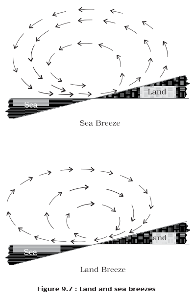
Mountain and Valley Winds
| Wind | Conditions and movement | Key feature |
|---|---|---|
| Valley breeze | Day: heated slopes make air rise upslope; air from the valley moves up the valley to replace it. | Upslope and up-valley flow |
| Mountain wind | Night: cooled slopes produce dense air that descends into the valley. | Downslope flow |
| Katabatic wind | Cool air drains from high plateaus and ice fields into valleys. | Cool, dense downslope flow |
| Leeward descending wind | Moisture in air crossing the mountain range condenses and precipitates. The dry air descends on the leeward slope and warms by adiabatic processes. | Dry, warm air may rapidly melt snow |
Air Masses
Air mass — A large body of air with little horizontal variation in temperature and moisture.
- Formation: Air remaining over a homogeneous surface for a long time takes on that area's temperature and moisture characteristics.
- Source region: The extensive, uniform surface over which an air mass forms, such as an ocean or plain.
- Temperature: Tropical air masses are warm; polar air masses are cold.
| Type | Source region | Temperature stated in the text |
|---|---|---|
| Maritime tropical (mT) | Warm tropical and subtropical oceans | Tropical air masses are warm |
| Continental tropical (cT) | Subtropical hot deserts | Tropical air masses are warm |
| Maritime polar (mP) | Relatively cold high-latitude oceans | Polar air masses are cold |
| Continental polar (cP) | Very cold, snow-covered high-latitude continents | Polar air masses are cold |
| Continental arctic (cA) | Permanently ice-covered continents in the Arctic and Antarctica | Not specified individually |
Fronts
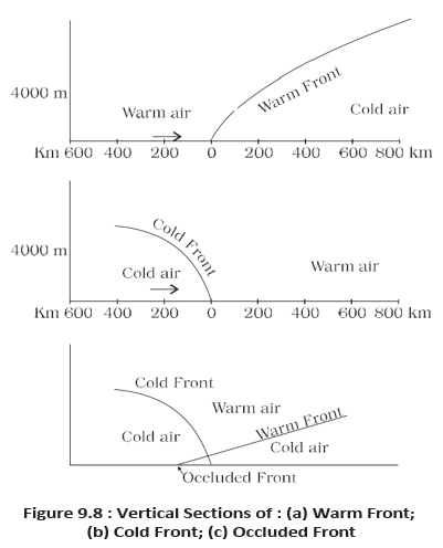
Front — The boundary zone where two different air masses meet.
- Frontogenesis
- The process by which fronts form.
- Cold front
- The contact zone formed when cold air advances toward warm air.
- Warm front
- The contact zone formed when warm air advances toward cold air.
- Stationary front
- A front that remains in place.
- Occluded front
- A front formed when an air mass is lifted completely above the land surface.
| Front type | How it forms |
|---|---|
| Cold | Cold air moves toward a warm air mass. |
| Warm | Warm air moves toward a cold air mass. |
| Stationary | The front remains stationary. |
| Occluded | An air mass is lifted completely above the land surface. |
Fronts and Weather
- Location: Fronts occur mainly in the middle latitudes.
- Boundary: They have steep temperature and pressure gradients.
- Weather effects: Fronts bring abrupt temperature changes; air rises near them, forming clouds and precipitation.
How do sea and land breezes form?
What is an air mass, and how are its types classified?
What are fronts, and what weather do they bring?
Quick recap
- Seasonal shifts in heating and pressure belts modify wind circulation; monsoons are the clearest example.
- Sea breezes blow sea-to-land by day; land breezes blow land-to-sea at night.
- Valley breezes rise by day, while mountain winds descend at night; katabatic winds drain cool air from high plateaus and ice fields into valleys.
- Air masses take on the temperature and moisture characteristics of their source regions and are classified as mT, cT, mP, cP or cA.
- Fronts form where air masses meet; the four types are cold, warm, stationary and occluded.
- Fronts occur mainly in middle latitudes and are associated with steep temperature and pressure gradients, rising air, clouds and precipitation.
Extra Tropical Cyclones
Extra-Tropical Cyclones
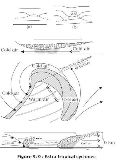
Extra-Tropical and Tropical Cyclones
- Circulation: Surface and upper-air wind circulation are closely linked in extra-tropical cyclones.
| Point | Extra-Tropical Cyclone | Tropical Cyclone |
|---|---|---|
| Fronts | Has a clear frontal system. | Does not have a clear frontal system. |
| Origin | Can originate over land or sea. | Originates over the sea; it weakens after reaching land. |
| Area affected | Usually affects a larger area. | Usually affects a smaller area. |
| Winds and damage | Wind velocity is lower and it is generally less destructive. | Wind velocity is higher and it is more destructive. |
| Direction of movement | Generally moves west to east. | Generally moves east to west. |
Tropical Cyclones
Landfall and Movement
- Landfall: The place where a tropical cyclone crosses the coast.
- After landfall: Its ocean moisture supply is cut off, so it weakens and eventually dissipates over land.
- Recurvature: Cyclones that cross N generally recurve and are more destructive.
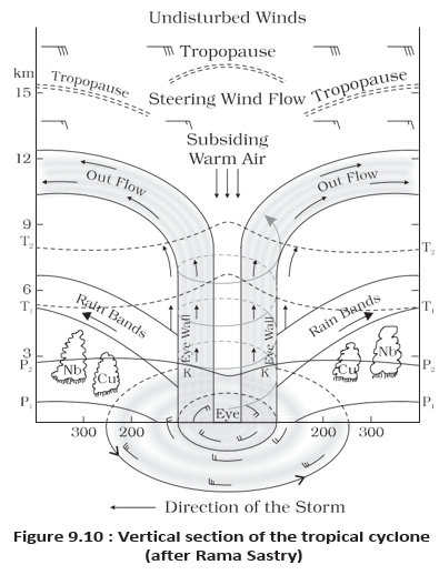
Structure of a Mature Tropical Cyclone
- Eye: The calm central region, where air subsides.
- Eyewall: Surrounds the eye; air spirals upward as high as the tropopause. It has the strongest winds—up to 250 km per hour—and torrential rain.
- Rain bands: Bands of cumulus and cumulonimbus clouds radiate outward from the eyewall.
- Size and movement: The circulating system is about 150–250 km in diameter; storms over the Bay of Bengal, Arabian Sea and Indian Ocean span about 600–1,200 km and move about 300–500 km per day.
- Coastal impact: Storm surges can inundate low-lying coastal areas.
Thunderstorms and Tornadoes
Storms and Atmospheric Energy
- Tornado distribution: Tornadoes generally occur in the middle latitudes.
- Energy change: These storms convert potential and heat energy into kinetic energy.
- Atmospheric adjustment: Storms express the atmosphere’s response to uneven energy distribution; after the storm, the atmosphere moves back toward a stable state.
- Polar front
- The boundary along which warm and cold air masses meet in middle and high latitudes.
- Occlusion
- The stage when the faster cold front overtakes the warm front and lifts the warm air from the surface.
- Eye
- The calm, central region of a mature tropical cyclone, with subsiding air.
- Landfall
- The place where a tropical cyclone crosses the coast.
- Storm surge
- A rise of sea water driven toward the coast by a cyclone, which can flood lowlands.
- Water spout
- A tornado occurring over the sea.
How does an extra-tropical cyclone develop and dissipate?
Name the main parts of a mature tropical cyclone and describe the eyewall.
What is a tornado, and what is it called when it occurs over the sea?
Quick recap
- Extra-tropical cyclones form along the polar front; occlusion occurs when the faster cold front overtakes the warm front.
- Compared with tropical cyclones, extra-tropical cyclones have clear fronts, affect larger areas and generally move west to east.
- Tropical cyclones need warm ocean water, Coriolis force, weak vertical wind-speed variation, a low-pressure disturbance and upper-air divergence.
- A mature tropical cyclone has a calm eye, a violent rainy eyewall and outward rain bands; landfall cuts off its moisture supply.
- Thunderstorms grow through intense convection; severe storms may produce tornadoes, called water spouts when over the sea.
Geography — ALL CHAPTERS
1
GEOGRAPHY AS A DISCIPLINE
2
THE ORIGIN AND EVOLUTION OF THE EARTH
3
INTERIOR OF THE EARTH
4
DISTRIBUTION OF OCEANS AND CONTINENTS
5
Geomorphic Processes
6
Landforms And Their Evolution
7
Composition And Structure Of Atmosphere
8
Solar Radiation, Heat Balance And Temperature
9
Atmospheric Circulation And Weather Systems
10
Water In The Atmosphere
11
World Climate And Climate Change
12
Water ( Oceans )
13
Movements Of Ocean Water
14
Biodiversity And Conservation
1
India - Location
2
Structure And Physiography
3
Drainage System
4
Climate
5
Natural Vegetation
6
Natural Hazards And Disasters