Class 11 Humanities . Geography . Fundamental Of Physical Geography . Water Oceans
Chapter 12: Water ( Oceans )
Ch 12
Geography
Class 11 Humanities
Hydrological Cycle & Relief Of The Ocean Floor
Water on Earth
- Importance: Water is essential for all life forms.
- Blue Planet: Earth has abundant surface water, which is rare in the solar system; this gives the planet its name.
Hydrological Cycle
Hydrological cycle — The continuous circulation and exchange of water among the oceans, atmosphere, land, subsurface and living organisms.
How the cycle works
- Forms: Water circulates in liquid, solid and gaseous phases.
- Movement: Water moves between oceans, land and atmosphere, and is continually reused.
- Importance: The cycle has operated for billions of years and supports all life on Earth.
- Distribution: Water is unevenly distributed; some places have abundant supplies while others have limited water.
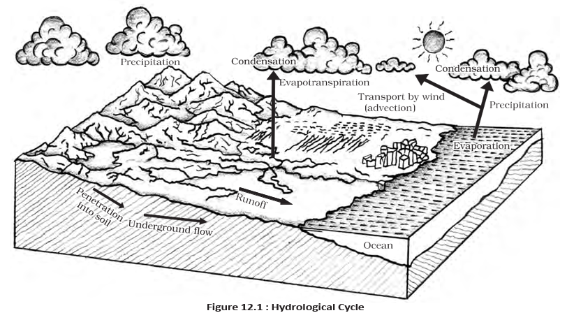
| Component or storage | Main processes |
|---|---|
| Water stored in oceans | Evaporation; evapotranspiration; sublimation |
| Water in the atmosphere | Condensation; precipitation |
| Water stored in ice and snow | Snowmelt runoff to streams |
| Surface runoff | Stream flow; freshwater storage; infiltration |
| Groundwater storage | Groundwater discharge; springs |
Water Distribution and Availability
- Ocean share: About 71% of the planet’s water is in the oceans.
- Freshwater stores: The remainder is held in glaciers and icecaps, groundwater, lakes, soil moisture, the atmosphere, streams and living organisms.
- Return to the atmosphere: Nearly 59% of the water that falls on land returns to the atmosphere through evaporation over oceans and other places.
- Other pathways: The rest runs off the surface, infiltrates into the ground or becomes part of glaciers.
- Water crisis: Renewable water on Earth is constant while demand is increasing, causing shortages that vary across places and over time.
- Additional pressure: River-water pollution further worsens the crisis.
Relief of the Ocean Floor
Ocean floor relief — The varied topography of the land beneath the oceans, shaped by tectonic, volcanic and depositional processes.
Ocean basins and topography
- Ocean basins: Oceans occupy the great depressions of Earth’s outer layer.
- Connected oceans: Oceans merge naturally, making their boundaries difficult to distinguish.
- Five oceans: The Pacific, Atlantic, Indian, Southern and Arctic oceans divide the oceanic part of Earth.
- Related waters: Seas, bays, gulfs and other inlets form parts of the oceans.
- Depth: A major portion of the ocean floor lies 3–6 km below sea level.
- Relief: The rugged ocean floor includes the world’s largest mountain ranges, deepest trenches and largest plains.
- Formation: Ocean-floor features are formed by tectonic, volcanic and depositional processes.
- Evaporation
- The change of liquid water into water vapour.
- Condensation
- The change of water vapour into liquid water.
- Runoff
- Water flowing over the land surface into streams and other water bodies.
- Infiltration
- Water entering and moving into the ground.
- Ocean floor relief
- The varied shapes and elevations of the seabed.
Quick recap
- Earth is called the Blue Planet because it has abundant surface water, a rare resource in the solar system.
- The hydrological cycle continuously circulates water among oceans, atmosphere, land, subsurface and organisms in liquid, solid and gaseous forms.
- The cycle includes processes such as evaporation, condensation, precipitation, runoff, infiltration and groundwater discharge.
- About 71% of Earth’s water is in the oceans; nearly 59% of water falling on land returns to the atmosphere.
- Constant renewable water supplies, rising demand and river pollution contribute to water crises that vary by place and time.
- The five oceans are the Pacific, Atlantic, Indian, Southern and Arctic; they merge naturally and are difficult to demarcate.
- Most of the ocean floor lies 3–6 km below sea level and has rugged mountains, trenches and plains formed by tectonic, volcanic and depositional processes.
Divisions of the Ocean Floors
Major Divisions of the Ocean Floor
The four major divisions
- Sequence: Continental shelf → continental slope → deep-sea plain → oceanic deeps or trenches.
- Additional relief: Ridges, hills, seamounts, guyots, trenches and submarine canyons also shape the ocean floor.
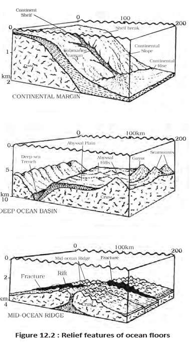
Continental Shelf
Continental shelf — The shallow, submerged extension of a continent, usually covered by shallow seas and gulfs.
- Gradient: The shallowest ocean-floor division, with an average slope of about or less; it ends at a steep shelf break.
- Width: Averages about , but varies widely. Shelves are narrow or nearly absent off Chile and western Sumatra.
- Largest shelf: The Siberian shelf in the Arctic Ocean reaches about in width.
- Depth: Varies from about to .
- Sediments and resources: Rivers, glaciers and wind bring sediments from land; waves and currents redistribute them. Long-term deposits can become sources of fossil fuels.
Continental Slope
Continental slope — The steep zone connecting the continental shelf to the ocean basins.
- Start: Begins where the shelf floor drops sharply; its boundary marks the end of the continent.
- Gradient and depth: The slope is about –; depths range from to .
- Relief: Canyons and trenches occur in this region.
Deep-Sea Plain
Deep-sea plain — A gently sloping, flat and smooth part of an ocean basin, generally at depths of –.
- Surface material: Usually covered with fine-grained sediments such as clay and silt.
- Character: These are the flattest and smoothest regions of the world.
Oceanic Deeps or Trenches
Oceanic deep or trench — A narrow, steep-sided basin forming one of the deepest parts of the ocean.
- Depth: Trenches lie about – below the surrounding ocean floor.
- Location and activity: They occur at the bases of continental slopes and along island arcs; many are associated with active volcanoes and strong earthquakes.
- Importance: Their association with earthquakes and volcanoes makes them important for studying plate movements.
- Known deeps: Of the explored, are in the Pacific, in the Atlantic and in the Indian Ocean.
Minor Relief Features
| Feature | Description | Example or key fact |
|---|---|---|
| Mid-oceanic ridge | Two mountain chains separated by a large depression. | Peaks may reach or rise above the sea. Iceland lies on the Mid-Atlantic Ridge. |
| Seamount | Pointed, volcanic mountain rising from the seafloor but not reaching the surface. | May be – tall. The Emperor seamount extends the Hawaiian Islands in the Pacific. |
| Submarine canyon | Deep valley that may cut across shelves and slopes, often extending from a large river mouth. | Some are comparable in size to the Grand Canyon; Hudson Canyon is a well-known example. |
| Guyot | Flat-topped seamount, showing evidence of gradual subsidence. | More than seamounts and guyots are estimated to occur in the Pacific alone. |
| Atoll | Low tropical island made of coral reefs surrounding a central depression. | The central lagoon may contain seawater or fresh, brackish or highly saline water. |
Temperature of Ocean Waters
Basic pattern
- Heating and cooling: Solar energy heats ocean water, but ocean water warms and cools more slowly than land.
- Overall pattern: Ocean temperature varies horizontally across regions and vertically with depth; it generally decreases toward the poles and downward.
Factors Affecting Ocean Temperature
| Factor | Effect on ocean temperature |
|---|---|
| Latitude | Surface temperature falls from equator to poles as incoming solar energy decreases poleward. |
| Land–water distribution | Northern Hemisphere oceans receive more heat because they are in contact with a larger land area than Southern Hemisphere oceans. |
| Prevailing winds | Offshore winds move warm surface water away from coasts, bringing cold water up from below (upwelling). Onshore winds pile warm water near coasts and raise temperatures. |
| Ocean currents | Warm currents raise temperatures in colder regions; cold currents lower temperatures in warmer regions. |
Examples of current effects
- Warm Gulf Stream → raises temperatures near eastern North America and western Europe.
- Cold Labrador Current → lowers temperatures near the northeastern coast of North America.
Enclosed seas
- Low latitudes: Enclosed seas are generally warmer than open seas.
- High latitudes: Enclosed seas are generally cooler than open seas.
Horizontal and Vertical Temperature Distribution
Thermocline — A boundary zone in which ocean temperature decreases rapidly with increasing depth.
Thermocline and deep water
- Position: The thermocline usually begins about – below the surface and extends several hundred metres downward.
- Deep ocean: About of total ocean-water volume lies below the thermocline, where temperatures approach .
- Temperature profile: The surface is warmest; temperature falls rapidly to about and then decreases more slowly.
- Heat transfer: The surface receives direct solar heat, which is carried to deeper water by convection.
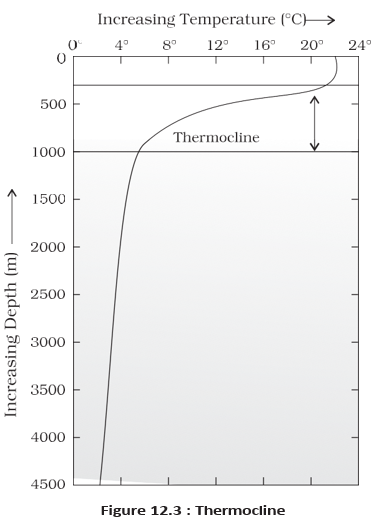
| Layer | Depth or thickness | Temperature and characteristics |
|---|---|---|
| Surface warm layer | About thick | About –. Present year-round in the tropics; develops in mid-latitudes mainly during summer. |
| Thermocline layer | About – thick | Temperature decreases rapidly as depth increases. |
| Deep cold layer | Extends to the deep-ocean floor | Very cold water; deep-ocean temperatures approach . |
| Middle and low latitudes | Arctic and Antarctic regions | |
|---|---|---|
| Vertical structure | Usually three layers: warm surface, thermocline and deep cold water. | Usually one cold-water layer from surface to ocean floor. |
| Reason | Warm surface water contrasts with colder deep water. | Surface temperatures are already close to , so temperature changes little with depth. |
Surface-temperature pattern
- Average: Global mean surface-water temperature is about and generally decreases toward the poles.
- Latitude gradient: The average decline is about per degree of latitude; values are about at , at and near the poles.
- Warmest zone: The highest surface temperature occurs slightly north of the equator, not exactly at the equator.
- Hemispheres: Average annual ocean temperatures are about in the Northern Hemisphere and in the Southern Hemisphere, largely reflecting unequal land–water distribution.
- Shelf break
- The steep drop marking the outer edge of the continental shelf.
- Upwelling
- The rise of cold water from below when surface water is driven away from a coast.
- Thermocline
- The ocean layer where temperature falls rapidly with depth.
- Guyot
- A flat-topped seamount formed through gradual subsidence.
Name the four major divisions of the ocean floor.
What is the thermocline, and where is most ocean water found in relation to it?
How do prevailing winds and ocean currents affect coastal ocean temperatures?
Quick recap
- The ocean floor is divided into continental shelf, continental slope, deep-sea plain and oceanic deeps.
- The shelf is shallow and sediment-covered; the slope descends to the ocean basin; plains are flat; trenches are narrow and very deep.
- Ridges, seamounts, submarine canyons, guyots and atolls are important minor relief features.
- Ocean temperature is influenced by latitude, land–water distribution, prevailing winds and ocean currents.
- The thermocline is the zone of rapid temperature decline; most ocean water lies below it.
- Surface waters are warmest; convection transfers heat downward, while temperatures generally decrease poleward and with depth.
Salinity Of Ocean Waters
Meaning and Measurement of Salinity
Salinity — The total amount of dissolved salts in seawater, measured as grams of salt per 1,000 g of seawater.
Usually expressed in parts per thousand (ppt or ‰). Salinity of is the upper limit used to distinguish brackish water.
| Water body | Location | Salinity |
|---|---|---|
| Lake Van | Turkey | |
| Dead Sea | ||
| Great Salt Lake |
Factors Affecting Ocean Salinity
| Factor | Effect on salinity |
|---|---|
| Evaporation | Removes water and generally raises surface salinity. |
| Precipitation | Adds fresh water and generally lowers surface salinity. |
| River water | Freshwater inflow lowers salinity, especially near coasts and estuaries. |
| Freezing and thawing | Ice formation and melting change salinity in polar regions. |
| Wind | Transfers water between areas, altering local salinity. |
| Ocean currents | Carry water with different salinities from one region to another. |
| Temperature and density | Salinity, temperature and density are linked; changes in temperature or density affect local salinity patterns. |
Horizontal Distribution of Salinity
General Pattern
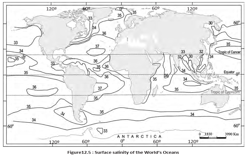
- Open oceans: Normal surface salinity is about –.
- Red Sea: Salinity reaches about in this landlocked sea.
- Estuaries and Arctic: Salinity can vary seasonally from to .
- Hot, dry regions: Strong evaporation can raise salinity to about .
| Region | Pattern | Main reason |
|---|---|---|
| Pacific Ocean | Pattern varies with its shape and large area. In the western Northern Hemisphere, salinity falls from about to ; south of about – S, it falls to about . | Meltwater from the Arctic lowers salinity in the north; the basin's shape and extent influence variation. |
| Atlantic Ocean | Average is about . Highest values occur around – latitude; a maximum of about occurs between N– N and W– W. Salinity decreases northward. | Regional evaporation, freshwater input and currents shape the pattern. |
| North Sea | Relatively high salinity despite its high latitude. | The North Atlantic Drift brings more saline water. |
| Baltic Sea | Low salinity. | Large quantities of river water enter the sea. |
| Mediterranean Sea | High salinity. | High evaporation. |
| Black Sea | Very low salinity. | Large freshwater inflow from rivers. |
| Indian Ocean | Average salinity is about . The Bay of Bengal is less saline, while the Arabian Sea is more saline. | The Bay of Bengal receives much river water; the Arabian Sea has high evaporation and little freshwater inflow. |
Vertical Distribution of Salinity
| Point | Surface water | Deep water |
|---|---|---|
| Salinity changes | Changes with evaporation, ice formation or melting, and freshwater input from rivers. | Relatively stable because water is not readily lost and salt is not added. |
| General pattern | Varies by location and conditions. | Lower-salinity water generally lies above denser, higher-salinity water; salinity usually increases with depth. |
Halocline — A distinct ocean layer in which salinity increases sharply with depth.
Salinity and Ocean Layering
- Higher salinity increases seawater density.
- Denser, high-salinity water sinks beneath lower-salinity water.
- The water layers become arranged by salinity, producing stratification.
- Salinity
- Total dissolved salt content of water.
- Brackish water
- Water with salinity at or below the stated upper limit of .
- Halocline
- Layer where salinity rises sharply with depth.
- Stratification
- Layering of ocean water by differences in salinity and density.
Why is the Arabian Sea more saline than the Bay of Bengal?
What is a halocline, and how does salinity affect seawater density?
Quick recap
- Salinity is dissolved salt content, commonly measured in grams per 1,000 g of seawater or in parts per thousand.
- Evaporation generally raises salinity; precipitation and river inflow generally lower it.
- Ocean salinity varies by region: the Red Sea is highly saline, while river-fed seas such as the Baltic and Black seas are less saline.
- The Atlantic averages about and the Indian Ocean about .
- Salinity usually increases with depth, with a sharp rise in the halocline.
- Higher-salinity water is denser and tends to sink, creating salinity-based stratification.
Geography — ALL CHAPTERS
1
GEOGRAPHY AS A DISCIPLINE
2
THE ORIGIN AND EVOLUTION OF THE EARTH
3
INTERIOR OF THE EARTH
4
DISTRIBUTION OF OCEANS AND CONTINENTS
5
Geomorphic Processes
6
Landforms And Their Evolution
7
Composition And Structure Of Atmosphere
8
Solar Radiation, Heat Balance And Temperature
9
Atmospheric Circulation And Weather Systems
10
Water In The Atmosphere
11
World Climate And Climate Change
12
Water ( Oceans )
13
Movements Of Ocean Water
14
Biodiversity And Conservation
1
India - Location
2
Structure And Physiography
3
Drainage System
4
Climate
5
Natural Vegetation
6
Natural Hazards And Disasters