Class 11 Humanities . Geography . India Physical Environment . Drainage System
Chapter 3: Drainage System
Ch 3
Geography
Class 11 Humanities
Drainage System
Drainage and River Flow
Important Drainage Patterns
- Drainage pattern: The arrangement of river channels reflects the geology, rock structure, relief, slope and flow of water in an area.
- Main patterns: Dendritic patterns resemble tree branches; radial rivers flow outward from a hill; trellis tributaries meet at right angles; centripetal rivers flow into a lake or depression.
Catchment Areas, Basins and Watersheds
Indian Drainage by Direction of Discharge
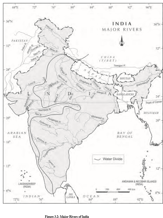
- Two drainage groups: Indian rivers drain either into the Arabian Sea or into the Bay of Bengal.
- Water divide: The Delhi Ridge, Aravalis and Sahyadris separate the two groups. About 77% of India’s drainage area flows to the Bay of Bengal and 23% to the Arabian Sea.
Indian Drainage by Catchment-Area Size
- Major basins: More than 20,000 sq. km of catchment area; India has 14, including the Ganga, Brahmaputra, Krishna, Narmada and Tapi.
- Medium basins: Catchment areas of 2,000–20,000 sq. km; these include 44 river basins, such as the Periyar and Meghna.
- Minor basins: Less than 2,000 sq. km of catchment area; many occur in regions of low rainfall.
Himalayan and Peninsular Drainage
- Drainage system
- The network of well-defined channels through which water flows.
- Catchment area
- The area from which a river collects water.
- Drainage basin
- The area drained by a river and its tributaries.
- Watershed
- The boundary separating drainage basins; the term may also refer to the small catchment of a rivulet or rill.
How do a drainage basin and a watershed differ?
Name the two Indian drainage divisions by direction of discharge and state their approximate shares.
Quick recap
- Drainage is water flowing through defined channels; the channel network is a drainage system.
- Drainage patterns include dendritic, radial, trellis and centripetal.
- Basin is the river-drained area; a watershed separates basins, and basins are usually larger.
- Discharge direction: about 77% of India’s drainage flows to the Bay of Bengal and 23% to the Arabian Sea.
- Basin-size classes: major, more than 20,000 sq. km; medium, 2,000–20,000 sq. km; minor, under 2,000 sq. km.
- Main origin-based classes are Himalayan and Peninsular drainage; the Narmada and Tapi are notable Arabian Sea-flowing rivers.
Drainage Systems Of India
Indian Drainage: Overview
Indian drainage system — The network of small and large rivers shaped by India’s three major physiographic units and the nature of precipitation.
The Himalayan Drainage
Main characteristics
- Major basins: The Indus, Ganga and Brahmaputra are the main Himalayan river systems.
- Water supply: Snowmelt and precipitation feed these rivers, making them perennial.
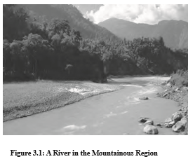
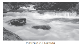
- Mountain course: Uplift and erosion create deep gorges; rivers also form V-shaped valleys, rapids and waterfalls.
- Plain course: Rivers form flat valleys, ox-bow lakes, flood plains, braided channels and deltas.
- Changing courses: Himalayan channels are tortuous; in the plains, meandering rivers can shift course frequently.
Why the Kosi shifts its course
- Large sediment loads come down from the Kosi’s upper reaches.
- Sediment is deposited across the plains.
- Deposition blocks the river channel.
- The Kosi shifts course, earning it the name “Sorrow of Bihar.”
Evolution of the Himalayan Drainage
Geological development
- Miocene period (about 5–24 million years ago)Geologists propose that the Shiwalik or Indo-Brahma was a mighty river running from Assam across the Himalaya to Punjab and Sind, ending in the Gulf of Sind near lower Punjab.
- Pleistocene periodUplift in the western Himalaya, including the Potwar Plateau, is thought to have helped divide the ancient drainage.
- Mid-Pleistocene periodDownthrusting around the Malda gap diverted the Ganga and Brahmaputra systems towards the Bay of Bengal.
| Evidence | Interpretation | |
|---|---|---|
| Ancient river | The Shiwalik has remarkable continuity, lacustrine origin and alluvial deposits of sands, silt, clay, boulders and conglomerates. | Geologists propose that the Shiwalik or Indo-Brahma was once a mighty river across the region. |
| Three drainage systems | The ancient river’s course is considered to have been disrupted by geological changes. | It is thought to have split into the Indus system in the west, the Ganga system centrally and the Brahmaputra system in the east. |
How the ancient drainage was divided
- Western system: The Indus and its five tributaries formed the western drainage.
- Central system: The Ganga and its Himalayan tributaries formed the central drainage.
- Eastern system: The Brahmaputra stretch in Assam and its Himalayan tributaries formed the eastern drainage.
- Water divide: Uplift of the Potwar Plateau (Delhi Ridge) is thought to have separated the Indus and Ganga drainage systems.
- Bay of Bengal outlet: Downthrusting of the Malda gap, between the Rajmahal Hills and Meghalaya Plateau, diverted the Ganga and Brahmaputra systems towards the Bay of Bengal.
The Indus River System
Indus (Sindhu) — The westernmost Himalayan river in India and one of the world’s largest river basins.
| Feature | Details |
|---|---|
| Basin area | 1,165,000 sq. km overall; 321,289 sq. km in India |
| River length | 2,880 km overall; 1,114 km in India |
| Source | Glacier near Bokhar Chu in Tibet, at 4,164 m in the Kailash range (31^\\circ 15' \\mathrm{N}, 81^\\circ 40' \\mathrm{E}) |
| Upper course | Known as Singi Khamban (“Lion’s mouth”) in Tibet; flows northwest between the Ladakh and Zaskar ranges |
| Route | Passes through Ladakh and Baltistan, cuts a gorge near Gilgit, and enters Pakistan near Chilas in Dardistan |
| Mouth | Flows south and enters the Arabian Sea east of Karachi |
| Indian course | Within India, the Indus flows through Jammu and Kashmir |
Indus tributaries
- Himalayan tributaries: Shyok, Gilgit, Zaskar, Hunza, Nubra, Shigar, Gasting and Dras join the Indus.
- Kabul River: Joins the Indus on its right bank near Attock.
- Other right-bank tributaries: Khurram, Tochi, Gomal, Viboa and Sangar rise in the Sulaiman ranges.
- Panjnad: The collective name for the five Punjab rivers—Satluj, Beas, Ravi, Chenab and Jhelum; it joins the Indus above Mithankot.
| River | Source and course |
|---|---|
| Jhelum | Rises at a spring in Verinag, at the foot of Pir Panjal; flows through Srinagar and Wular Lake, then enters Pakistan through a deep, narrow gorge. Joins the Chenab near Jhang. |
| Chenab | Formed by the Chandra and Bhaga streams, which meet at Tandi near Keylong in Himachal Pradesh. Also called Chandrabhaga; flows 1,180 km before entering Pakistan. |
| Ravi | Rises west of Rohtang Pass in the Kullu hills; flows through Chamba Valley and joins the Chenab near Sarai Sidhu in Pakistan. |
| Beas | Rises at Beas Kund near Rohtang Pass, at 4,000 m; flows through Kullu Valley and forms gorges at Kati and Largi in the Dhauladhar range. Joins the Satluj near Harike. |
| Satluj | Rises at Raksas Tal near Mansarovar in Tibet, at 4,555 m; called Langchen Khambab there. Flows almost parallel to the Indus for about 400 km before entering India; passes through Shipki La and emerges from a gorge at Rupar into the Punjab plains. |
Importance and river characteristics
- Jhelum: Flows through Wular Lake before entering Pakistan.
- Chenab: The largest tributary of the Indus.
- Beas: Its course includes gorges in the Dhauladhar range.
- Satluj: An antecedent river; it feeds the canal system of the Bhakra Nangal project.
- Perennial river
- A river that flows throughout the year; Himalayan rivers are sustained by snowmelt and precipitation.
- Panjnad
- The combined name for the Satluj, Beas, Ravi, Chenab and Jhelum rivers.
- Water divide
- A high area of land that separates the drainage of neighbouring river systems.
Why has the Kosi frequently changed its course?
How did the ancient Indo-Brahma drainage system develop into three major river systems?
Quick recap
- Himalayan rivers are perennial because they receive both snowmelt and precipitation.
- Mountain reaches have gorges, V-shaped valleys, rapids and waterfalls; plains have depositional features and meanders.
- Kosi shifts course when heavy sediment deposits obstruct its channel.
- Indo-Brahma hypothesis: An ancient river is thought to have divided into the Indus, Ganga and Brahmaputra drainage systems.
- Indus rises in Tibet, flows through Jammu and Kashmir in India, and drains into the Arabian Sea.
- Panjnad comprises the Satluj, Beas, Ravi, Chenab and Jhelum; the Satluj feeds canals of the Bhakra Nangal project.
The River Systems Of The Himalayan Drainage
The Ganga System
Ganga — India’s most important river by basin size and cultural significance; its river system is the country’s largest.
Ganga: source and course
- Source: The Bhagirathi rises from the Gangotri Glacier near Gaumukh (3,900 m), in Uttarkashi district, Uttarakhand.
- Upper course: The Bhagirathi cuts narrow gorges through the Central and Lesser Himalayas.
- Name change: At Devprayag, the Bhagirathi meets the Alaknanda; downstream, it is called the Ganga.
- Alaknanda: It rises in the Satopanth Glacier above Badrinath. The Dhauli and Vishnu Ganga meet at Joshimath (Vishnu Prayag).
- Alaknanda tributaries: The Pindar joins at Karna Prayag; the Mandakini (Kali Ganga) joins at Rudra Prayag.
- Plains and course: The Ganga enters the plains at Haridwar, then flows south, south-east and east.
- Distributaries: In its lower course, it splits into the Bhagirathi and Padma.
- Length and basin: It is 2,525 km long; its Indian basin covers about 8.6 lakh sq. km.
| State | Length |
|---|---|
| Uttarakhand | 110 km |
| Uttar Pradesh | 1,450 km |
| Bihar | 445 km |
| West Bengal | 520 km |
Namami Gange Programme
- Approval and aims: Approved by the Union Government as a flagship programme in June 2014; its objectives are pollution abatement, conservation and rejuvenation of the Ganga.
- Main pillars: Sewage treatment infrastructure, river-front development, river-surface cleaning and biodiversity.
- Other pillars: Afforestation, public awareness, industrial effluent monitoring and Ganga Gram.
Ganga basin and tributaries
- River types: The system includes perennial rivers originating in the Himalayas to the north and non-perennial rivers rising in the Peninsula to the south.
- Right bank: The Son is the Ganga’s major right-bank tributary.
- Important left-bank tributaries: Ramganga, Gomati, Ghaghara, Gandak, Kosi and Mahananda.
- Outflow: The Ganga finally enters the Bay of Bengal near Sagar Island.
Major Ganga Tributaries
Yamuna
- Source and meeting point: It rises in the Yamunotri Glacier on the western slopes of the Banderpunch range (6,316 m) and joins the Ganga at Prayag (Allahabad).
- Significance: It is the Ganga’s westernmost and longest tributary.
- Right-bank tributaries: Chambal, Sind, Betwa and Ken; these originate on the Peninsular Plateau.
- Left-bank tributaries: Hindan, Rind, Sengar and Varuna, among others.
- Irrigation: Much of its water feeds the Western and Eastern Yamuna canals and the Agra Canal.
Chambal
- Source and course: It rises near Mhow on the Malwa Plateau in Madhya Pradesh, flows north through a gorge upstream of Kota, then passes Bundi, Sawai Madhopur and Dholpur before joining the Yamuna.
- Dam: The Gandhi Sagar Dam is built in the gorge upstream of Kota.
- Landform: The Chambal is known for its badland topography, called the Chambal ravines.
Gandak and Ghaghara
- Gandak: Formed by the Kaligandak and Trishulganga, it rises in the Nepal Himalayas between Dhaulagiri and Mount Everest. It drains central Nepal, enters the Ganga plain in Champaran district, Bihar, and joins the Ganga at Sonpur near Patna.
- Ghaghara: It rises in the Mapchachungo glaciers; the Tila, Seti and Beri add their waters before it cuts a deep gorge at Shishapani.
- Ghaghara’s course: The Sarda (Kali or Kali Ganga) joins it in the plains; the Ghaghara then meets the Ganga at Chhapra.
Kosi and Ramganga
- Kosi: An antecedent river whose source lies north of Mount Everest in Tibet; its main stream, the Arun, rises there.
- Kosi tributaries: After crossing Nepal’s Central Himalayas, the Arun is joined by the Son Kosi from the west and Tamur Kosi from the east; together they form the Sapt Kosi.
- Ramganga: It rises in the Garhwal hills near Gairsain, turns south-west after crossing the Shiwalik, and enters the Uttar Pradesh plains near Najibabad.
- Ramganga’s course: It finally joins the Ganga near Kannauj.
Damodar and Sarda
- Damodar: It flows along the eastern margin of the Chotanagpur Plateau through a rift valley, then joins the Hugli; the Barakar is its main tributary.
- Damodar management: Once called the “sorrow of Bengal,” it has been controlled through the multipurpose Damodar Valley Corporation project.
- Sarda (Saryu): It rises in the Milam Glacier in the Nepal Himalayas, where it is called the Goriganga.
- Sarda’s names and course: Along the Indo-Nepal border it is called the Kali or Chauk; it joins the Ghaghara.
Mahananda and Son
- Mahananda: It rises in the Darjiling hills and joins the Ganga in West Bengal as its last important left-bank tributary.
- Son: A large south-bank tributary, it rises in the Amarkantak Plateau and forms waterfalls at the plateau’s edge before reaching Arrah, west of Patna, where it joins the Ganga.
The Brahmaputra System
Brahmaputra — One of the world’s largest rivers, rising in the Kailash range and flowing through Tibet, India and Bangladesh.
Brahmaputra: course and names
- Chemayungdung Glacier, Kailash range, near Lake Manasarovar
- Flows east for nearly 1,200 km across southern Tibet as the Tsangpo (“the purifier”); the Rango Tsangpo is its major right-bank tributary there.
- Cuts a deep gorge near Namcha Barwa (7,755 m) through the Central Himalayas; emerges from the foothills as the Siang or Dihang.
- Enters India west of Sadiya, Arunachal Pradesh; after receiving the Dibang (Sikang) and Lohit, it is known as the Brahmaputra.
- Flows through the Assam Valley for about 750 km, then enters Bangladesh near Dhubri.
- The Tista joins from the right bank in Bangladesh; the river is then called the Jamuna and merges with the Padma, which flows into the Bay of Bengal.
| Region / bank | Tributaries | Key detail |
|---|---|---|
| Tibet | Rango Tsangpo — right bank | Major right-bank tributary in Tibet. |
| India: left bank | Dibang (Sikang), Lohit; Burhi Dihing and Dhansari (South) | Dibang and Lohit join before the river is known as the Brahmaputra. |
| India: right bank | Subansiri, Kameng, Manas and Sankosh | The Subansiri rises in Tibet and is an antecedent river. |
| Bangladesh: right bank | Tista | After the Tista joins, the river is called the Jamuna. |
Why the Brahmaputra floods and shifts its channel
- Heavy rainfall across the catchment
- Large tributaries carry substantial water and sediment
- High sediment loads and river flow increase instability
- Frequent floods, channel shifting and bank erosion
- Tributary
- A river or stream that flows into a larger river.
- Distributary
- A branch that carries water away from a main river.
- Antecedent river
- A river that maintains its course across rising terrain by cutting through it.
- Rift valley
- A long, narrow depression formed by movement of the Earth’s crust.
- Badland topography
- An eroded landscape of gullies and ravines, as seen along the Chambal.
Quick recap
- The Ganga begins as the Bhagirathi and takes the name Ganga at Devprayag; it enters the plains at Haridwar.
- The Ganga basin spans about 8.6 lakh sq. km in India, and the river empties into the Bay of Bengal near Sagar Island.
- Namami Gange, approved in June 2014, aims to reduce pollution and conserve and rejuvenate the Ganga through eight programme pillars.
- The Son is a major right-bank tributary; the Ramganga, Gomati, Ghaghara, Gandak, Kosi and Mahananda are important left-bank tributaries.
- The Yamuna is the Ganga’s westernmost and longest tributary; its right-bank tributaries include the Chambal, Sind, Betwa and Ken.
- The Brahmaputra is called the Tsangpo in Tibet, Siang or Dihang as it enters India, and Jamuna in Bangladesh.
- Heavy rainfall and sediment-rich tributaries make the Brahmaputra prone to floods, channel shifting and bank erosion.
The Peninsular Drainage System
Characteristics of Peninsular Rivers
- Age and valleys: The Peninsular drainage is older than the Himalayan system; its rivers generally have broad, shallow, graded valleys.
- River courses: Most major rivers flow east to the Bay of Bengal, while the Western Ghats divide them from short streams flowing to the Arabian Sea. Peninsular rivers generally have fixed courses, few meanders and seasonal flow.
Evolution of the Drainage System
Effects of Rift-Valley Flow
- Narmada and Tapi: Flow through trough faults formed by the cracks in the Peninsular block.
- Deposits: Their river valleys lack the alluvial and deltaic deposits commonly found in other major rivers.
Major River Systems
- East-flowing systems: The Mahanadi, Godavari, Krishna and Kaveri are the major Peninsular rivers that drain into the Bay of Bengal.
- Other systems: The Narmada and Tapi flow west to the Arabian Sea, while the Luni is the largest river system west of the Aravalis in Rajasthan.
- Ganga tributaries: The Chambal, Sind, Betwa, Ken and Son rise in the northern Peninsula and are part of the Ganga river system.
Extent and Use of River Water
Major Problems in Using River Water
- Availability: Insufficient water in some places or seasons.
- Pollution: River water is contaminated by wastes and other human activities.
- Silt: River water carries a load of silt.
- Seasonality: Flow varies greatly between wet and dry seasons.
- Disputes: States may disagree over the sharing of river water.
- Channel narrowing: Settlements extending towards the thalweg—the deepest part of a channel—can shrink the river channel.
River Pollution
- Water divide
- A highland or ridge that separates the drainage basins of rivers.
- Rift valley
- A long trough formed by faulting; the Narmada and Tapi flow through such troughs.
- Ephemeral river
- A river system that flows only temporarily, rather than throughout the year.
- Estuary
- A tidal river mouth where river water meets the sea.
- Thalweg
- The deepest line or part of a river channel.
Why are the Narmada and Tapi different from most Peninsular rivers?
Why does the Kaveri carry water throughout the year with relatively little fluctuation?
Quick recap
- The Peninsular drainage system is older and more mature than the Himalayan system.
- Most major Peninsular rivers flow east; the Narmada and Tapi flow west through rift valleys.
- Subsidence, faulting and a northwest-to-southeast tilt shaped the drainage pattern.
- Godavari is the largest Peninsular river system; Krishna is the second-largest east-flowing one.
- River water is unevenly distributed by season and region, contributing to floods and droughts.
- Pollution, silt, seasonal flow, state disputes and shrinking channels are important river-water problems.
Geography — ALL CHAPTERS
1
GEOGRAPHY AS A DISCIPLINE
2
THE ORIGIN AND EVOLUTION OF THE EARTH
3
INTERIOR OF THE EARTH
4
DISTRIBUTION OF OCEANS AND CONTINENTS
5
Geomorphic Processes
6
Landforms And Their Evolution
7
Composition And Structure Of Atmosphere
8
Solar Radiation, Heat Balance And Temperature
9
Atmospheric Circulation And Weather Systems
10
Water In The Atmosphere
11
World Climate And Climate Change
12
Water ( Oceans )
13
Movements Of Ocean Water
14
Biodiversity And Conservation
1
India - Location
2
Structure And Physiography
3
Drainage System
4
Climate
5
Natural Vegetation
6
Natural Hazards And Disasters