Class 11 Humanities . Geography . Fundamental Of Physical Geography . Landforms and Their Evolution
Chapter 6: Landforms And Their Evolution
Ch 6
Geography
Class 11 Humanities
Introduction, Running Water & Erosional Landforms
Landforms, Landscapes and Evolution of Landforms
Landform — A small-to-medium-sized part or parcel of the Earth's surface.
Landscape — A large tract of the Earth's surface made up of several related landforms.
Landform Characteristics and Change
- Characteristics: Each landform has its own physical shape, size and material, resulting from particular geomorphic processes and agents.
- Timescale: Most geomorphic processes act slowly, so landforms often take a long time to develop; continued processes can change them slowly or rapidly.
- Changing conditions: Climate change and vertical or horizontal movements of landmasses may alter processes or their intensity.
| Aspect | Meaning |
|---|---|
| Surface transformation | A part of the Earth's surface changes from one landform into another. |
| Landform transformation | An already formed landform changes in shape, size or nature. |
Running Water as a Geomorphic Agent
- Geomorphic agents: Running water, groundwater, wind, glaciers and waves erode earth materials after weathering has acted on them; erosion and deposition both change the Earth's surface.
- Importance: In humid regions with heavy rainfall, running water is a major agent of land-surface degradation.
- Two forms of flow: Overland flow moves as a sheet across the land; linear flow moves through stream and river channels.
- Slope and erosion: Steep, youthful rivers erode vigorously, especially downward; as channels become gentler, their velocity falls and deposition becomes more active.
- Gentle slopes: Gentler gradients generally favour greater deposition. Downward cutting becomes less dominant, while lateral erosion of banks increases.
- Long-term result: Valley sides and divides are lowered, reducing hills and valleys, though complete flattening may leave resistant remnants.
From Overland Flow to a Peneplain
- Sheet flow erodes the land surface → narrow rills form.
- Rills enlarge, deepen and lengthen → gullies develop.
- Gullies deepen, widen and lengthen, then unite → a network of valleys forms.
- Early down-cutting removes irregularities such as waterfalls and cascades → later lateral erosion lowers valley sides and divides.
- Relief is reduced to a faintly undulating lowland with resistant remnants called monadnocks → a peneplain (almost plain) forms.
Peneplain — A nearly level surface formed by prolonged stream erosion, often with a few resistant monadnocks standing above it.
Monadnock — A low, resistant remnant that stands above the faint-relief surface of a peneplain.
| Stage | Streams and valleys | Floodplains, divides and other features |
|---|---|---|
| Youth | Few, poorly integrated streams; shallow V-shaped valleys; trunk streams have no floodplain or a very narrow one. | Broad, flat divides with marshes, swamps and lakes; meanders may form on uplands and later become entrenched; waterfalls and rapids may occur where hard rock is exposed. |
| Mature | Many, well-integrated streams; deep V-shaped valleys; trunk streams have wider floodplains and meanders confined within valleys. | Broad inter-stream areas, swamps and marshes disappear; divides become sharp; waterfalls and rapids disappear. |
| Old | Few smaller tributaries with gentle gradients; streams meander freely. | Vast floodplains with natural levees and oxbow lakes; broad, flat divides may have lakes, swamps and marshes; most of the landscape is at or slightly above sea level. |
Erosional Landforms
Valleys, Gorges and Canyons
- Valley development: Rills enlarge into gullies, which deepen, widen and lengthen to form valleys.
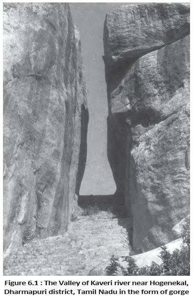
- Valley types: Depending on dimensions, shape and the rocks in which they form, valleys include V-shaped valleys, gorges and canyons.
| Point | Gorge | Canyon |
|---|---|---|
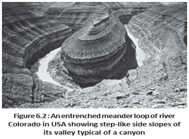
| Shape | Deep valley with very steep to nearly straight sides; top and bottom are almost equal in width. | Deep valley with steep, step-like sides; wider at the top than at the bottom. |
| Typical rock setting | Commonly forms in hard rocks. | Commonly forms in horizontally bedded sedimentary rocks. |
| Relationship | A distinct steep-sided valley type. | A variant of a gorge. |
Potholes and Plunge Pools
Pothole — A roughly circular depression eroded into the rocky bed of a hill stream.
Formation of Potholes and Plunge Pools
- Potholes: Flowing water rotates pebbles and boulders in a small depression; their abrasion enlarges and deepens it.
- Joining: A series of potholes may join, further deepening the stream valley.
- Plunge pools: Large, deep holes form at waterfall bases through the impact of water and the rotation of boulders.
Incised or Entrenched Meanders
Incised or entrenched meander — A very deep and wide meander cut into hard rock.
Meandering Courses
- Steep gradients: Erosion is normally concentrated on the stream bed; lateral erosion of valley sides is comparatively limited.
- Gentle gradients: Active lateral erosion helps streams develop sinuous or meandering courses, commonly across floodplains and delta plains.
- Entrenched forms: Very deep and wide meanders may be found cut into hard rocks.
River Terraces
River terrace — A surface marking an old valley-floor or floodplain level.
Formation and Identification
- Origin: Terraces are basically erosional features formed when a stream cuts vertically into its own depositional floodplain.
- Former levels: Several terraces at different heights indicate former river-bed levels.
- Paired terraces: Terraces at the same elevation on both sides of a river are called paired terraces.
| Type | Composition |
|---|---|
| Bedrock terrace | Bedrock surface without alluvial cover. |
| Alluvial terrace | Terrace consisting of stream deposits. |
- Landform
- A small-to-medium-sized part of the Earth's surface.
- Landscape
- A large tract made up of related landforms.
- Peneplain
- A nearly level surface produced by prolonged stream erosion.
- Monadnock
- A resistant remnant standing above a peneplain.
- Paired terraces
- River terraces at the same elevation on both sides of a river.
Quick recap
- Landforms are small-to-medium surface features; related landforms form larger landscapes.
- Evolution includes change of a surface into new landforms and later modification of existing landforms.
- Running water acts as sheet flow or channel flow; steep slopes favour vigorous erosion, while gentler slopes encourage deposition and lateral erosion.
- Peneplains are nearly level surfaces shaped by stream erosion and may retain resistant monadnocks.
- Youth, mature and old stages differ in stream integration, valley shape, floodplains, divides and river features.
- Erosional landforms include valleys, gorges, canyons, potholes, plunge pools, entrenched meanders and river terraces.
Depositional Landforms
Alluvial Fans
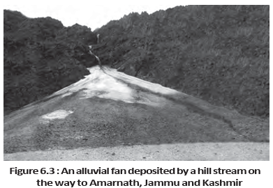
Alluvial fan — A broad, cone-shaped deposit formed where a stream leaves a steep mountain slope and spreads onto a gentler foot-slope plain.
- Formation: Coarse mountain-stream load becomes too heavy to carry over a gentler gradient, so it is deposited and spread out.
- Channels: Streams often shift across the fan, forming many channels called distributaries.
- Climate: Fans in humid regions are usually low and gently sloping; those in arid and semi-arid regions are typically higher and steeper.
Deltas
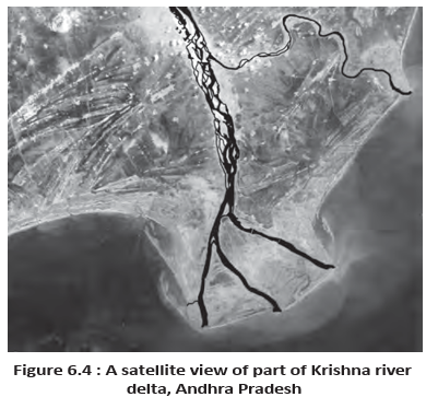
Delta — A low, cone-shaped deposit formed when a river’s load accumulates at its mouth rather than being carried far out to sea or along the coast.
- Sorting: Delta deposits are well sorted and clearly stratified; coarse material settles first, while finer silt and clay travel farther into the sea.
- Growth: As the delta builds outward, river distributaries lengthen and extend into the sea.
- Comparison: Deltas form at river mouths, while alluvial fans form where streams emerge from high ground onto gentler plains.
Floodplains, Natural Levees and Point Bars
Floodplain — A depositional area beside a river, built mainly from sediments laid down in the channel and across its banks during floods.
- Deposition: Coarser material is deposited first; slower water in gentle plain channels carries and deposits finer sand, silt and clay.
- Active floodplain: The river bed made of river deposits.
- Inactive floodplain: The area above the banks, containing channel deposits and flood deposits.
- Channel deposits: Lateral channel shifts can leave abandoned or cut-off courses, which gradually fill with relatively coarse material.
- Flood deposits: Water spilling over the banks lays down finer material, especially silt and clay.
- Delta plain: The floodplain area within a delta.
| Point | Natural levees | Point bars |
|---|---|---|
| Location | Along the banks of large rivers | Along meander banks; the lecture text places them on the concave side |
| Form and material | Low, linear, parallel ridges of coarse deposits; sometimes separated into mounds | Linear deposits of flowing water, with mixed sediment sizes and a fairly uniform profile and width |
| Other name | — | Meander bars |
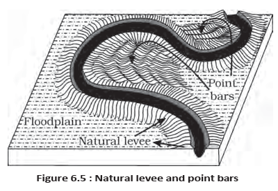
How do natural levees differ from point bars?
Meanders
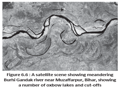
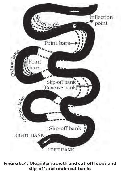
Meander — A loop-like river-channel pattern that commonly develops across large floodplains and delta plains; it is a channel pattern, not a landform.
- Conditions: Very gentle gradients encourage water to work laterally; unconsolidated alluvial banks and their irregularities help bends develop.
- Additional influence: The Coriolis force deflects flowing water, as it deflects wind.
- Growth: Small bank irregularities develop into curves; deposition on the inside and erosion along the outside deepen the bends.
- Bank features: The lecture describes the concave bank as a steep cut-off bank and the convex bank as having a long, gentle profile.
- Oxbow lakes: Deep meander loops may be cut off by erosion at their inflection points, leaving isolated curved water bodies.
Groundwater and Karst Topography
How groundwater works on rocks
- Percolation: Surface water enters rocks most readily when they are permeable, thinly bedded, and strongly jointed or cracked.
- Movement: Water moves downward, then flows horizontally through bedding planes, joints, cracks or the rock material.
- Landform effect: Physical removal of rock by groundwater is usually insignificant; chemical solution and precipitation are especially important in limestone and dolomite rich in calcium carbonate.
Karst topography — A landscape of characteristic erosional and depositional landforms produced by groundwater solution and deposition in limestone or dolomite regions.
Groundwater landform development
- Water percolates through permeable, jointed or cracked rock
- It moves downward and then horizontally through the rock
- Solution and precipitation act on limestone or dolomite
- Erosional and depositional karst landforms develop
- Rock setting: Karst features may form where limestone or dolomite occurs alone or in layers between other rock types.
- Name: The term comes from the characteristic limestone terrain of the Karst region in the Balkans, beside the Adriatic Sea.
- Distributary
- A channel branching away from a river, including across a fan or delta.
- Active floodplain
- The river bed made up of river deposits.
- Natural levee
- A low ridge of coarse sediment running beside a river bank.
- Point bar
- A linear deposit associated with a meander, also called a meander bar.
- Oxbow lake
- A curved water body left when a meander loop is cut off.
- Karst topography
- Limestone or dolomite terrain shaped by groundwater solution and deposition.
Quick recap
- Alluvial fans form where coarse stream load is deposited as water leaves steep slopes; shifting channels create distributaries.
- Deltas build outward at river mouths, with sorted and stratified deposits and lengthening distributaries.
- Floodplains include active river beds and inactive areas above banks, built from channel and flood deposits.
- Natural levees are coarse bank-parallel ridges; point bars are linear meander deposits.
- Meanders are channel patterns shaped by lateral water action; cut-off loops can leave oxbow lakes.
- Karst topography develops chiefly through groundwater solution and deposition in limestone and dolomite.
Erosional Landforms, Pools, Sinkholes, Lapies And Limestone Pavements
Pools, Sinkholes, Lapies and Limestone Pavements
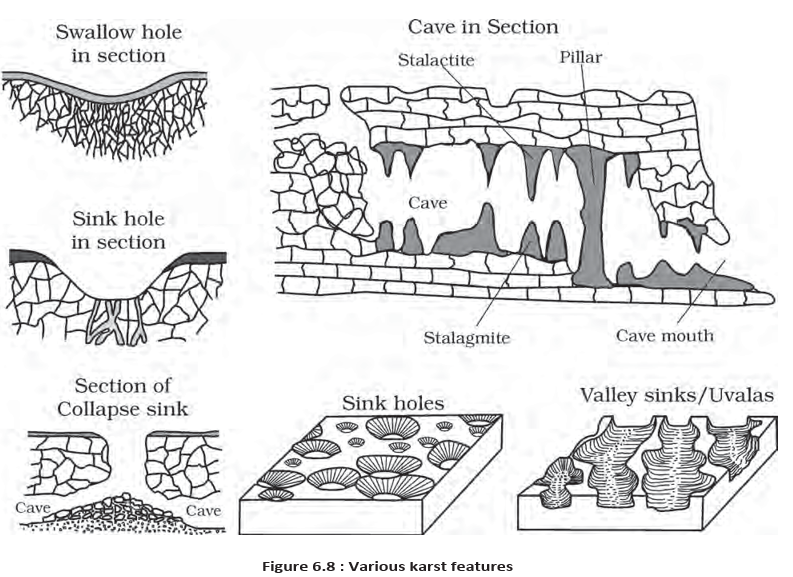
Swallow hole — A small or medium, round to sub-rounded shallow depression formed on limestone by solution.
Sinkhole — A generally circular opening at the top that becomes funnel-shaped below, formed in limestone or karst terrain.
Sinkholes
- Size: Sinkholes range from a few square metres to about a hectare in area, and from less than half a metre to over 30 metres deep.
- Solution sink: Forms directly through the dissolving action of water; this type is more common.
- Collapse sink: A solution sink may develop above an underground cave or void; collapse of its roof creates a large opening.
- Doline: A name sometimes used for a collapse sink.
- Hidden danger: Soil may cover a sinkhole, making it look like a shallow pool; the ground can give way under a person.
- Underground drainage: Runoff can descend through swallow holes and sinkholes, flow underground, then re-emerge downstream through a cave opening.
Development of Karst Surface Features
- Solution and collapse form sinkholes and dolines.
- Slumping along their margins or cave-roof collapse causes neighbouring depressions to join.
- Long, narrow to wide trenches called valley sinks or uvalas develop.
- Continued solution leaves an irregular surface of points, grooves and ridges called lapies.
- A lapie field may eventually turn into a somewhat smooth limestone pavement.
Lapies and Limestone Pavements
- Lapies: Ridges and grooves produced by differential solution, especially along parallel or sub-parallel joints in limestone.
- Limestone pavement: A somewhat smooth surface that may eventually develop from a lapie field.
Caves
Cave — A long gap or passage formed as water dissolves limestone along bedding planes.
Cave Formation and Features
- Favourable rocks: Caves are prominent where limestone or dolomite occurs in thick, massive beds, or between layers of rocks such as shale, sandstone and quartzite.
- Water movement: Water percolates through rock or cracks and joints, then travels horizontally along bedding planes.
- Dissolution: Limestone dissolves along these planes, producing gaps that range from narrow passages to wide caves.
- Cave systems: Different limestone beds and intervening rocks can produce a maze of caves at several elevations.
- Openings: Caves commonly discharge cave streams through an opening; a cave open at both ends is a tunnel.
Depositional Landforms in Limestone Caves
How Cave Deposits Form
- Dissolving agent: Calcium carbonate, the chief chemical in limestone, dissolves readily in carbonated water—rainwater containing absorbed carbon dioxide.
- Deposition: Dissolved calcium carbonate is deposited when water evaporates or loses carbon dioxide as it trickles over rough cave surfaces.
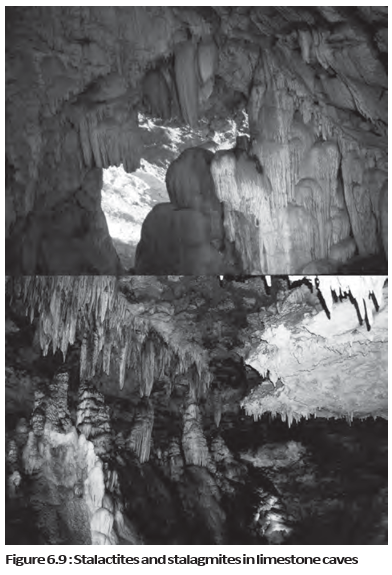
Stalactites, Stalagmites and Pillars
| Feature | Stalactites | Stalagmites |
|---|---|---|
| Position | Hang from the cave roof | Rise from the cave floor |
| Formation | Build downward as mineral-bearing water trickles | Form below dripping water, including water from a stalactite or its thin pipe |
| Typical shapes | Icicle-like; often broad at the base and tapering towards the free end | May form columns, discs, rounded bulges or miniature crater-like depressions |
Pillars
- Formation: A stalactite and stalagmite may eventually meet and fuse, forming a column or pillar.
Glaciers
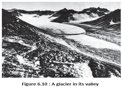
Glacier — A mass of ice moving over land, either as a broad sheet or as a flow down a mountain valley.
| Type | Form and location |
|---|---|
| Continental glacier | A vast sheet of ice spread over land. |
| Piedmont glacier | A vast sheet of ice spread over plains at the foot of mountains. |
| Mountain or valley glacier | A linear flow moving down mountain slopes through broad, trough-like valleys. |
Glacier Movement and Himalayan Examples
- Movement: Glaciers move slowly under gravity—commonly a few centimetres to a few metres per day, though the rate can be less or more.
- Himalayan glaciers: Glaciers flow down slopes and valleys in the higher reaches of Uttarakhand, Himachal Pradesh and Jammu and Kashmir.
- River sources: Meltwater from the snout (Gaumukh) of the Gangotri Glacier feeds the Bhagirathi; the Alkapuri Glacier feeds the Alakananda.
- Confluence: The Alakananda and Bhagirathi join near Deoprayag to form the Ganga.
Glacial Erosion
Erosional Action
- Force: The great weight of moving ice creates intense friction against the land.
- Plucking and abrasion: Glaciers detach material, often large angular blocks and fragments, then drag it along valley floors and sides, wearing and damaging rock.
- Erosive power: Glaciers can erode even unweathered rock and reduce high mountains to low hills and plains.
Long-Term Effects of Glacial Erosion
- Moving glaciers remove debris and lower divides.
- Continued erosion reduces the land slope.
- When the slope becomes sufficiently gentle, glaciers stop moving.
- The landscape may be left as low hills, vast outwash plains and other depositional features.
- Doline
- A term sometimes used for a collapse sink.
- Uvala
- A long trench formed when sinkholes or dolines join.
- Lapies
- Limestone ridges and grooves shaped by differential solution.
- Tunnel
- A cave with openings at both ends.
- Snout
- The lower end of a glacier; Gaumukh is the snout of the Gangotri Glacier.
How do sinkholes develop into uvalas and lapies?
How are stalactites, stalagmites and pillars formed?
What causes glacier erosion, and what landscape can it leave behind?
Quick recap
- Swallow holes and sinkholes form through solution; some sinkholes also result from cave-roof collapse.
- Joined sinkholes form uvalas; continued solution shapes lapies, and a lapie field may eventually become a limestone pavement.
- Water dissolves limestone along bedding planes to form caves; caves open at both ends are tunnels.
- Evaporation or carbon dioxide loss deposits calcium carbonate, forming stalactites, stalagmites and pillars.
- Glaciers move slowly under gravity and occur as broad ice sheets or mountain-valley flows.
- Glacial weight, plucking and abrasion erode rock, lower divides and can leave low hills and outwash plains.
Cirque / Horns And Serrated Ridges
Erosional Landforms: Cirques
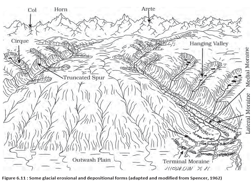
Cirque — A deep, wide basin or trough cut by ice, commonly found at the head of a glacial valley.
- Occurrence: Cirques are the most common landforms in glaciated mountains and are often found at the heads of glacial valleys.
- Shape and formation: Accumulated ice cuts deep, long, wide basins with steep concave-to-vertical head and side walls as it moves down mountain tops.
- Tarn lake: A lake remaining in a cirque after its glacier disappears is called a cirque lake or tarn.
- Stepped cirques: Two or more cirques may occur one below another in a descending sequence.
Horns and Serrated Ridges
Horn — A high, sharp, steep-sided peak formed when three or more radiating glaciers erode headward until their cirques meet.
- Serrated ridge: Progressive erosion narrows the divides between cirque side walls or headwalls into sharp-crested, zigzag ridges, also called arêtes.
- Examples: Matterhorn in the Alps and Everest in the Himalayas are horns formed by headward erosion of radiating cirques.
Glacial Valleys and Troughs
- Glacial valley: A broad, U-shaped trough with a wide, relatively smooth floor and steep sides.
- Valley features: Floors may contain debris or moraines, swampy areas, and lakes gouged from rock or formed by debris.
- Hanging valleys: Smaller valleys may lie above the main valley on one or both sides; their projecting spurs are often truncated into triangular facets.
- Fjord (fiord): A very deep glacial trough filled with seawater, forming a shoreline feature in high latitudes.
| Point | Glacial valley | River valley |
|---|---|---|
| Main agent | Moving glacier | Running river |
| Form described in this lecture | Broad, U-shaped trough with a wide floor and steep sides | No specific shape or floor description given |
Depositional Landforms
| Point | Glacial till | Outwash deposits |
|---|---|---|
| How deposited | Dropped directly by melting glacier | Carried and deposited by meltwater streams |
| Sorting and layers | Unassorted mixture of coarse and fine debris | Roughly stratified and assorted |
| Fragment shape | Mostly angular to sub-angular | Edges are somewhat rounded |
- Glacio-fluvial deposits: Meltwater streams at the bottom, sides, or lower ends of glaciers carry smaller debris and deposit it as outwash.
Moraines
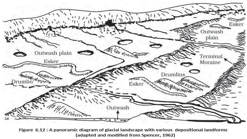
Moraine — A long ridge or spread of debris deposited by a glacier, chiefly made of glacial till.
| Type | Location / form | Key feature |
|---|---|---|
| Terminal | At the glacier's toe or end | Long ridge of deposited debris |
| Lateral | Along the sides, parallel to the glacial valley | May join a terminal moraine to form a horseshoe-shaped ridge; several may occur on each side |
| Ground | Spread over the valley floor | Irregular till sheet left by rapidly retreating valley glaciers; thickness and surface relief vary |
| Medial | Centre of the valley, between lateral moraines | Often imperfectly formed and may be hard to distinguish from ground moraine |
- Formation note: Glacio-fluvial waters can push material towards glacier sides, contributing partly or fully to lateral moraines.
Eskers
Esker — A sinuous ridge of stream-deposited material left beneath a glacier after its ice melts.
- Summer meltwater flows over the ice, seeps along its margins, or moves through holes in it.
- Water gathers beneath the glacier and flows in a channel, with ice forming the stream banks.
- Key distinction: The subglacial stream flows over the ground, not in a valley cut into the ground.
- Boulders, blocks, and some smaller debris settle in the ice channel; when the ice melts, the deposits remain as a sinuous ridge.
Outwash Plains
Outwash plain — A broad, flat area of glacio-fluvial deposits formed at the foot of glacial mountains or beyond continental ice-sheet limits.
- Deposits: Meltwater lays down gravel, silt, sand, and clay as broad, flat alluvial fans that may merge into an outwash plain.
| Point | River alluvial plain | Glacial outwash plain |
|---|---|---|
| Depositing agent | River water | Glacial meltwater |
| Formation described here | A plain formed by river-deposited alluvium | Broad, flat alluvial fans of glacio-fluvial deposits that may merge |
Drumlins
Drumlin — A smooth, oval, ridge-like hill composed mainly of glacial till, sometimes with gravel and sand.
- Size and alignment: Drumlins may reach about 1 km in length and 30 m in height; their long axes run parallel to ice movement.
- Stoss and tail: The glacier-facing stoss end is blunter and steeper; the tail is more tapered.
- Formation and use: Debris is dumped beneath heavily loaded ice through fissures; moving ice blunts the stoss end, so drumlins indicate ice-flow direction.
| Point | Till | Alluvium |
|---|---|---|
| Depositing agent | Glacial ice | Running water |
| Key description | Unassorted coarse and fine debris; fragments are mostly angular to sub-angular | Material deposited by running water |
Waves, Currents and Coastal Processes
- Coastal change: Coastal processes are highly dynamic and destructive; waves are the main agents of change, and a coast may experience erosion in one season and deposition in another.
- Breaking waves: Water strikes the shore forcefully and churns sea-floor sediments; repeated impact strongly reshapes coasts.
- High-energy waves: Storm waves and tsunamis can cause more extensive changes in a short time than ordinary breaking waves.
- Changing force: The force of breaking waves varies as the wave environment changes.
Coastal Types and Their Setting
- Controls: Coastal landforms depend on the configuration of the land and sea floor and on whether the coast is advancing seaward or retreating landward.
- Assumption: The classification of emerging and submerging coasts here assumes that sea level is constant.
- Emerging coast: The coast advances seaward; it is associated with low, smooth, gently sloping sedimentary coasts.
- Submerging coast: The coast retreats landward; it is associated with high, rocky coasts.
| Point | Emerging coast | Submerging coast |
|---|---|---|
| Relative change | Coast advances seaward | Coast retreats landward |
| Typical form | Low, smooth, gently sloping sedimentary coast | High, rocky coast |
Quick recap
- Cirques are common glacial-mountain basins; lakes left in them are tarns.
- Headward erosion by radiating cirques forms horns; erosion between cirques produces sharp arêtes.
- Glacial valleys are broad, U-shaped troughs; deeply flooded glacial troughs are fjords.
- Till is unsorted, angular debris dropped by ice, while meltwater sorts and stratifies outwash.
- Moraines, eskers, outwash plains, and drumlins are important glacial depositional landforms.
- Waves reshape coasts; coastal landforms also depend on coastal configuration and emergence or submergence, assuming constant sea level.
High Rocky Coasts
High rocky coast — A steep, irregular coast where erosion dominates and valleys may be flooded by the sea.
Coastal change
- Appearance: Coastlines are highly indented; flooded glacial valleys form fjords, and hillsides drop steeply into the water.
- Dominant process: Powerful waves erode the cliffs; depositional landforms are initially scarce.
- Cliff retreat: Wave pounding removes cliff material, leaving a wave-cut platform in front of the retreating cliff.
- Smoothing: Waves gradually reduce irregularities; eroded material breaks into rounded fragments and accumulates offshore.
- Later deposition: Additional offshore sediment can form a wave-built terrace in front of a wave-cut terrace.
- Beach and bar formation: Eroded sediment feeds longshore currents, which deposit beaches and offshore bars parallel to the coast.
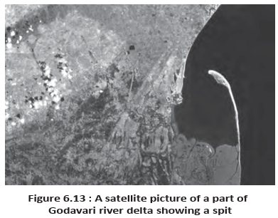
- Lagoon to plain: A bar exposed above water is a barrier bar; if it connects to a bay headland it forms a spit. Bars or spits may enclose a lagoon, which can fill with land-derived sediment and become a coastal plain.
Low Sedimentary Coasts
Low sedimentary coast — A gently sloping, generally smooth coast where deposition dominates because sediment is readily supplied.
Coastal features and development
- Appearance: Rivers extend the land through coastal plains and deltas; lagoons and tidal creeks interrupt the smooth coastline.
- Relief: The land slopes gently into the sea; marshes and swamps may be common.
- Depositional sequence: Waves churn and move bottom sediment, building bars, barrier bars, spits and lagoons; lagoons may become swamps and then coastal plains.
- Sediment supply: The continued existence of these features depends on a steady sediment supply. Large rivers build deltas by bringing abundant sediment.
- Extreme waves: Storm and tsunami waves can drastically alter coasts, regardless of sediment supply.
| Point | High rocky coast | Low sedimentary coast |
|---|---|---|
| Slope and shape | Steep, irregular and indented | Gently sloping and generally smooth |
| Dominant process | Erosion; cliffs retreat | Deposition; sediment builds the coast |
| Common features | Cliffs, wave-cut platforms and rocky shores | Beaches, bars, spits, lagoons, marshes and deltas |
| River influence | Valleys may be drowned by the sea | Rivers extend the coast by building plains and deltas |
| India | West coast: high, rocky and retreating; erosional forms dominate | East coast: low and sedimentary; depositional forms dominate |
Coastal Erosional Landforms
| Landform | Formation and features |
|---|---|
| Sea cliff | A steep coastal face, commonly several metres to 30 m or higher, cut and set back by wave erosion. |
| Wave-cut terrace | A flat or gently sloping platform with cliff debris at its foot; it is called a terrace when above the average height reached by waves. |
| Sea cave | Wave impact and rock debris enlarge hollows at a cliff base into caves; cave-roof collapse helps the cliff retreat inland. |
| Sea stack | An isolated resistant rock remnant left offshore when a retreating cliff or hill is worn back. |
Long-term coastal erosion
- Waves undercut cliffs and enlarge caves
- Cave roofs collapse; cliffs retreat inland
- Resistant rock remains as sea stacks
- Continued erosion lowers coastal relief; deposits may cover the resulting narrow plain and help form a wide beach
Coastal Depositional Landforms
| Feature | Definition and key points |
|---|---|
| Beach | A depositional shoreline made mainly of sand brought by rivers and streams or produced by wave erosion. Beaches are temporary and may change greatly between seasons. |
| Shingle beach | A beach made of small pebbles and sometimes cobbles rather than mainly sand. |
| Coastal sand dune | Sand lifted and winnowed from the beach by wind, then deposited behind it; long ridges parallel to the coast are common on low sedimentary coasts. |
| Feature | Definition and development |
|---|---|
| Offshore bar | A ridge of sand and shingle formed offshore, approximately parallel to the coast; bars may form across a river mouth or bay entrance. |
| Barrier bar | An offshore bar exposed above water through further addition of sand. |
| Spit | A barrier attached to one end of a bay or extending from a headland or hill. |
| Lagoon | A bay partly or fully enclosed as bars and spits extend across its mouth; it can gradually fill with sediment from land or beach. |
| Coastal plain | A broad plain that may develop as a lagoon fills with sediment. |
Coastal protection
- Natural buffers: Offshore bars absorb much of the force of storms and tsunamis; barriers, beaches, dunes and mangroves provide further protection.
- Sediment budget: Disturbing sediment supply or removing mangroves can erode these protective features, exposing coastal settlements to waves.
Wind Action in Deserts
Wind processes and desert erosion
- Desert winds: Dry, bare floors heat rapidly; rising hot air creates turbulence, eddies, whirlwinds, updrafts and downdrafts. Obstacles also generate turbulence, and storm winds can be destructive.
- Deflation: Wind lifts and removes dust and fine particles from rock or soil surfaces.
- Abrasion: Wind-driven sand and silt scrape and wear land surfaces during transport.
- Impact: Blown sand strikes rock with force, much like sand-blasting.
- Weathering and runoff: Drastic daily temperature changes expose desert rocks to mechanical and chemical weathering. Torrential, though infrequent, rain removes the debris, especially where vegetation is sparse.
- Other agents: Desert landforms also result from mass wasting and sheet floods; wind carries fine material, while sheet floods or sheet wash accomplish much general mass erosion.
- Stream channels: Desert channels are broad, smooth and indistinct, flowing briefly after rain.
Desert Erosional Landforms
| Landform | Definition and formation |
|---|---|
| Pediment | A gently inclined rocky floor near a mountain foot, with or without a thin debris cover; formed by lateral stream erosion and sheet flooding. |
| Parallel retreat | Backwasting in which a steep wash slope and free face retreat backwards while maintaining their general form. |
| Inselberg | An isolated remnant of a mountain left as surrounding slopes retreat. |
| Pediplain | A low, nearly featureless plain formed as pediments extend backward and reduce high relief. |
Pediment development
- Erosion begins along steep land margins or incision sides
- Streams and sheet floods cut gently sloping pediments
- Wash slopes and free faces retreat by backwasting
- Pediments widen at the expense of mountain fronts; isolated inselbergs may remain
- Relief is reduced to broad pediplains
Playa — A shallow, temporary lake in a desert basin where water gathers briefly before evaporation; salts commonly accumulate there.
Playas and salt flats
- Basin plain: Drainage flows towards the centre of enclosed basins; sediment from the margins builds a nearly level central plain.
- Water and salts: Temporary shallow lakes form when water is sufficient; evaporation leaves salt deposits.
- Alkali flat: A playa plain covered by salts is called an alkali flat.
| Landform | Formation and appearance |
|---|---|
| Deflation hollow | A shallow depression formed when persistent wind removes weathered material or bare soil. |
| Blowout and cave | Wind abrasion and impact create shallow pits or blowouts in rock; some deepen and widen into caves. |
| Mushroom rock | A resistant remnant with a narrow stalk and broad, rounded cap, shaped by wind erosion. |
| Table rock | A resistant rock remnant with a broad, table-like top. |
| Pedestal rock | A resistant rock remnant standing in a pedestal-like form. |
Desert Depositional Landforms
Wind deposition and sorting
- Wind as a sorting agent: Grains move by rolling, saltation or suspension according to wind velocity; transport sorts them by size.
- Deposition: As wind slows, grains settle according to their size and the wind speed needed to keep them moving.
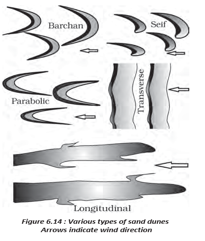
- Dune formation: Dunes can develop wherever there is a good sand supply, steady wind direction and obstacles to initiate accumulation.
| Type | Conditions | Shape or key feature |
|---|---|---|
| Barchan | Constant, moderate wind and a fairly uniform surface | Crescent-shaped; wings point downwind, away from the wind. |
| Parabolic | Sandy surfaces partly covered with vegetation | A reverse barchan; wind direction is the same. |
| Seif | A shift in wind conditions | Like a barchan but with one wing, which may grow long and high. |
| Longitudinal | Poor sand supply and constant wind direction | Long ridges of considerable length but low height. |
| Transverse | Constant wind; sand source elongated at right angles to the wind | Ridges perpendicular to wind direction; may be very long and low. |
Dune change
- Coalescence: When sand is abundant, individual dunes may merge and lose their distinct shapes.
- Movement: Most desert dunes shift over time; some, especially near human settlements, become stabilised.
- Fjord
- A sea-flooded glacial valley along a highly indented coast.
- Spit
- A depositional ridge attached to one end of a bay or a headland.
- Pediment
- A gently sloping rocky floor at the foot of a mountain in a desert.
- Pediplain
- A broad, low-relief plain formed by the expansion of pediments.
- Playa
- A temporary shallow lake in a desert basin, often with salt deposits.
- Deflation
- The lifting and removal of fine surface particles by wind.
How do high rocky coasts differ from low sedimentary coasts?
Name the main erosional landforms formed by wind and sheet floods in deserts.
What conditions form barchan, parabolic, seif, longitudinal and transverse dunes?
Quick recap
- High rocky coasts are steep, irregular and erosional; cliffs retreat and may leave platforms, caves and stacks.
- Low sedimentary coasts are gentle and depositional; bars and spits can enclose lagoons that fill into coastal plains.
- India: The west coast is mainly high and rocky; the east coast is mainly low and sedimentary.
- Desert erosion: Wind causes deflation, abrasion and impact; weathering supplies debris that sheet floods and sheet wash can remove.
- Pediplains and playas: Pediments expand into pediplains through slope retreat; playas are temporary basin lakes where salts may accumulate, not erosional landforms.
- Wind deposition sorts grains and builds dune types whose shapes depend on wind, sand supply and vegetation.
Geography — ALL CHAPTERS
1
GEOGRAPHY AS A DISCIPLINE
2
THE ORIGIN AND EVOLUTION OF THE EARTH
3
INTERIOR OF THE EARTH
4
DISTRIBUTION OF OCEANS AND CONTINENTS
5
Geomorphic Processes
6
Landforms And Their Evolution
7
Composition And Structure Of Atmosphere
8
Solar Radiation, Heat Balance And Temperature
9
Atmospheric Circulation And Weather Systems
10
Water In The Atmosphere
11
World Climate And Climate Change
12
Water ( Oceans )
13
Movements Of Ocean Water
14
Biodiversity And Conservation
1
India - Location
2
Structure And Physiography
3
Drainage System
4
Climate
5
Natural Vegetation
6
Natural Hazards And Disasters