Class 11 Humanities . Geography . Fundamental Of Physical Geography . Solar Radiation Heat Balance and Temperature
Chapter 8: Solar Radiation, Heat Balance And Temperature
Ch 8
Geography
Class 11 Humanities
Solar Radiation, Variability Of Insolation At The Surface Of The Earth
Atmosphere and Heat Transfer
- Energy balance: Earth receives energy from the Sun and radiates it back to space, maintaining its overall temperature.
- Heat transfer: Unequal heating creates atmospheric pressure differences and winds that transfer heat between regions.
Solar Radiation
| Position | Date | Distance from Sun | Meaning |
|---|---|---|---|
| Aphelion | 4 July | Earth is farthest from the Sun. | |
| Perihelion | 3 January | Earth is nearest to the Sun. |
Annual Variation in Solar Output
- Difference: Earth receives slightly more insolation at perihelion than at aphelion because it is closer to the Sun.
- Limited effect: Land–sea distribution and atmospheric circulation mask much of this small variation, so it has little effect on daily weather.
Variability of Insolation at Earth's Surface
Main Controls
- Variation: The amount and intensity of insolation change during the day, between seasons and over the course of a year.
- Main controls: Earth's rotation, the angle of the Sun's rays and the length of daylight.
- Other controls: Atmospheric transparency and land aspect (the orientation of a place's surface) also affect insolation, but have less influence.
- Axial tilt: Earth's axis is inclined at to the plane of its orbit; this strongly affects insolation at different latitudes.
| Point | More vertical rays | More slanting rays |
|---|---|---|
| Typical location | Lower latitudes | Higher latitudes |
| Area covered | Smaller area; energy is concentrated | Larger area; energy is spread out |
| Atmospheric path | Shorter path | Longer path, causing more absorption, scattering and diffusion |
| Energy per unit area | Greater | Lower |
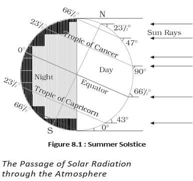
Passage of Solar Radiation through the Atmosphere
How Solar Radiation Interacts with the Atmosphere
- The atmosphere is largely transparent to incoming short-wave solar radiation.
- Water vapour, ozone and other gases in the troposphere absorb much of the near-infrared radiation.
- Tiny suspended particles scatter visible light both back to space and towards Earth's surface.
- Scattering produces the blue colour of the sky and the red colour of sunrise and sunset.
Spatial Distribution of Insolation
Global Patterns
- Latitudinal range: Surface insolation is about in the tropics and about at the poles.
- Maximum: Subtropical deserts receive the most insolation because cloudiness is least there.
- Equator and tropics: The Equator receives comparatively less insolation than the tropics.
- Land and sea: At the same latitude, continents generally receive more insolation than oceans.
- Seasonal contrast: Middle and higher latitudes receive less radiation in winter than in summer.
Heating and Cooling of the Atmosphere
| Process | How heat is transferred | Importance / example |
|---|---|---|
| Conduction | Direct contact transfers heat from a warmer body to a cooler one. | Heats the lower atmosphere; continues until temperatures equalise or contact ends. |
| Convection | Heated air rises vertically as currents and transfers heat upward. | Vertical heating is confined to the troposphere. |
| Advection | Air movement transfers heat horizontally. | Relatively more important than vertical movement; the summer loo in northern India is an example. |
Relative Importance
- Surface heating: Earth absorbs insolation and transfers heat to the air near the ground.
- Advection: In middle latitudes, much of the daily weather variation is caused by horizontal air movement.
Terrestrial Radiation
Terrestrial radiation — Long-wave energy emitted by Earth after its surface absorbs short-wave solar radiation.
Earth–Atmosphere Heat Balance
- Earth's surface absorbs incoming short-wave insolation and warms.
- The warmed surface emits long-wave terrestrial radiation, heating the atmosphere from below.
- Carbon dioxide and other greenhouse gases absorb much of this long-wave radiation.
- The atmosphere radiates and transfers heat onwards; ultimately, energy received from the Sun is returned to space, maintaining Earth's overall heat balance.
- Insolation
- Incoming solar radiation received by Earth.
- Aphelion
- Earth's farthest position from the Sun in its orbit.
- Perihelion
- Earth's nearest position to the Sun in its orbit.
- Conduction
- Heat transfer between bodies in direct contact.
- Convection
- Vertical transfer of heat by moving air.
- Advection
- Horizontal transfer of heat by moving air.
Why do higher latitudes generally receive less insolation per unit area?
Distinguish conduction, convection and advection.
How does terrestrial radiation heat the atmosphere?
Quick recap
- The atmosphere is Earth's envelope of gases; air in motion is wind, and winds help transfer heat between regions.
- Insolation is incoming short-wave solar radiation; Earth receives slightly more at perihelion than at aphelion.
- Earth's rotation, axial tilt, ray angle, daylight length and other factors cause daily, seasonal and latitudinal variations in insolation.
- Slanting rays spread energy over a larger area and travel through more atmosphere.
- Subtropical deserts receive maximum insolation; the poles receive much less.
- Conduction heats air near the ground, convection transfers heat vertically and advection transfers it horizontally.
- Earth emits long-wave terrestrial radiation, which greenhouse gases absorb; energy is ultimately returned to space.
Heat Budget of the Planet Earth
Earth’s Heat Budget
Heat budget (heat balance) — The balance in which Earth’s absorbed incoming solar energy equals the energy it returns to space, so Earth as a whole neither accumulates nor loses heat.
Global Energy Flow
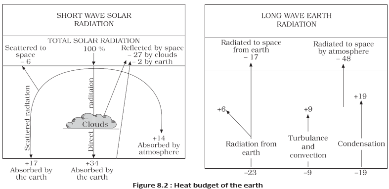
- Incoming insolation: Take the solar energy reaching the top of the atmosphere as 100 units.
- Atmospheric passage: Some energy is reflected, scattered and absorbed; the remaining energy reaches Earth’s surface.
- Reflection: About 35 units return to space before reaching the surface: 27 from cloud tops, 2 from snow- and ice-covered areas, and the remaining 6 as other reflected energy.
- Absorption: The remaining 65 units are absorbed: 14 by the atmosphere and 51 by Earth’s surface.
Albedo — The amount of incoming radiation reflected back to space by Earth and its atmosphere.
| Energy flow | Units | Details |
|---|---|---|
| Reflected to space | 35 | 27 from cloud tops, 2 from snow- and ice-covered areas, and 6 other reflected units. |
| Absorbed from insolation | 65 | 14 by the atmosphere and 51 by Earth’s surface. |
| Surface terrestrial radiation | 51 | 17 radiated directly to space; 34 absorbed by the atmosphere. |
| Atmospheric absorption of surface energy | 34 | 6 absorbed directly, 9 transferred through convection and turbulence, and 19 through latent heat of condensation. |
| Total atmospheric absorption | 48 | 14 from insolation plus 34 from terrestrial radiation. |
| Total radiation returned to space | 65 | 17 from Earth’s surface plus 48 radiated by the atmosphere. |
Why Earth’s Temperature Remains Balanced
- Atmospheric radiation: The atmosphere radiates the 48 units it absorbs back into space.
- Global balance: Radiation returning to space is units, equal to the 65 units absorbed from the Sun.
- Result: This balance explains why Earth does not continually warm up or cool down despite large heat transfers.
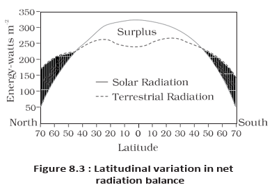
Variation in the Net Heat Budget at Earth’s Surface
Latitudinal Variation
- Uneven balance: Different regions receive and lose different amounts of radiation, creating areas of net surplus and net deficit.
- Surplus zone: Net radiation is in surplus between and .
- Deficit zones: Regions near the poles have a net radiation deficit.
- Redistribution: Excess heat moves poleward from the tropics, preventing continued tropical heating and permanent freezing at high latitudes.
Latitudinal Heat Redistribution
- Surplus net radiation in the tropics
- Excess heat is redistributed poleward
- Tropics avoid continual heat accumulation and high latitudes avoid permanent freezing
- Insolation
- Incoming solar radiation received by Earth.
- Terrestrial radiation
- Radiation emitted by Earth’s surface after absorbing solar energy.
- Albedo
- Incoming radiation reflected back to space.
- Net radiation balance
- The balance between radiation received and radiation lost in a region.
Quick recap
- Earth’s long-term heat balance depends on absorbed incoming solar energy equalling outgoing radiation.
- Of 100 incoming units, 35 are reflected and 65 are absorbed; energy passing through the atmosphere may also be scattered.
- Earth’s surface radiates 51 units: 17 escape directly to space and 34 are absorbed by the atmosphere.
- The atmosphere absorbs 48 units in total and radiates 48 units to space; combined outgoing radiation is 65 units.
- Net radiation is in surplus between and and in deficit near the poles.
- Poleward heat redistribution helps prevent tropical overheating and permanent freezing at high latitudes.
Temperature
Temperature — Temperature measures how hot or cold a substance or place is; heat represents the movement of its particles.
How Earth’s Surface and Atmosphere Warm
- Heating: Interaction of insolation with the atmosphere and Earth’s surface produces heat, which is measured as temperature.
Factors Controlling Temperature Distribution
| Factor | Effect on temperature |
|---|---|
| Latitude | Insolation varies with latitude, so temperature varies accordingly. |
| Altitude | Air is heated indirectly from Earth’s surface; temperature generally falls with increasing height. |
| Distance from the sea | The sea heats and cools slowly, moderating temperatures in nearby places; land heats and cools quickly. |
| Air masses and ocean currents | Warm air masses and currents raise temperatures; cold air masses and currents lower them. |
| Local aspects | Local conditions also influence the temperature of a place. |
Normal lapse rate — The normal lapse rate is the decrease in temperature with increasing altitude; its average rate is per .
Land, Sea and Air Circulation
- Land and sea: Land heats and cools faster than the sea, so temperature variation is greater over land than over water.
- Sea influence: Sea and land breezes moderate temperatures in coastal places.
- Air masses: Places under warm air masses have higher temperatures; those under cold air masses have lower temperatures.
- Ocean currents: Warm currents raise temperatures along coasts, while cold currents lower them.
Global Distribution of Temperature
Isotherms — Isotherms are lines joining places with equal temperature; they are used to show temperature distribution on maps.
General Pattern
- Latitude: Isotherms generally run parallel to latitudes, showing the strong influence of latitude on temperature.
- Hemispheres: Isotherm deviations are greater in January than in July, especially in the Northern Hemisphere, where land area is larger and land and ocean-current effects are stronger.
January Temperature Distribution
January Patterns and Values
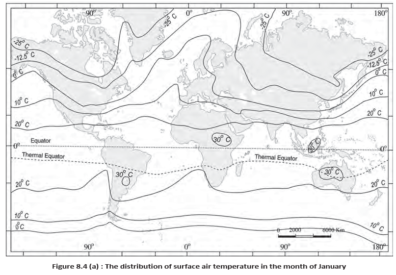
- Isotherm bends: In the Northern Hemisphere, January isotherms bend north over oceans and south over continents.
- North Atlantic: The warm Gulf Stream and North Atlantic Drift bend isotherms northward; colder continental interiors make them bend southward over Europe.
- Siberian plain: Along , the mean January temperature is about at both and .
- January temperatures: Mean monthly temperatures are above over equatorial oceans and above in the tropics.
- Continental interiors: Middle latitudes record about –; the Eurasian interior ranges from about to .
- Southern Hemisphere: Isotherms are more nearly parallel to latitudes, and temperatures change more gradually because ocean influence is stronger.
- Southern isotherms: The , and isotherms lie near , and , respectively.
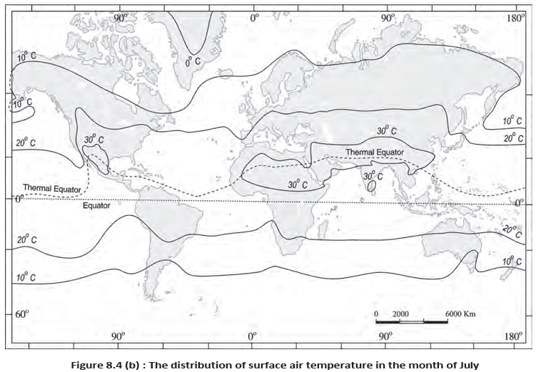
July Temperature Distribution
July Patterns and Values
- Isotherms: They generally run parallel to latitudes in July.
- Warm regions: Equatorial oceans are above ; subtropical continental Asia along exceeds .
- Middle latitudes: The isotherm runs near and .
Annual Range of Temperature
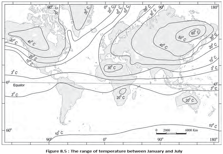
January–July Range
- Greatest range: More than occurs in north-eastern Eurasia, mainly due to continentality—the strong seasonal contrast of large land interiors.
- Smallest range: About occurs between and .
Inversion of Temperature
Inversion of temperature — Temperature inversion occurs when the normal pattern is reversed and temperature increases with height instead of decreasing.
Surface Inversion
- Ideal conditions: Long winter nights, clear skies and still air favour inversion.
- Formation: The ground loses heat by radiation overnight; by early morning it can be colder than the air above.
- Polar regions: Temperature inversion is normal throughout the year.
- Effects: Stable lower air traps smoke and dust beneath the inversion layer, spreading them horizontally; dense morning fog is common, especially in winter.
- Duration: Surface inversion often lasts only a few hours, until the Sun warms the ground.
Air drainage — Air drainage is the downslope flow of dense, cold air under gravity, where it collects in valley bottoms and hollows beneath warmer air.
Air Drainage and Frost Protection
- Cause: Cold air formed on hillsides at night is denser and flows downhill under gravity.
- Result: Cold air gathers in pockets and valley bottoms, with warmer air above—an inversion pattern.
- Benefit: Air drainage can protect plants from frost damage.
Radiation and Specific Heat
- Planck’s law
- The hotter a body is, the more energy it radiates and the shorter the wavelength of its radiation.
- Specific heat
- The energy required to raise the temperature of gram of a substance by .
Why do January isotherms bend north over the North Atlantic and south over Europe?
What conditions favour surface temperature inversion, and what are its effects?
Quick recap
- Temperature controls: Latitude, altitude, distance from the sea, air masses, ocean currents and local aspects shape temperature.
- Lapse rate: Temperature generally falls with height at about per .
- Isotherms: These join places of equal temperature and generally follow latitudes, with stronger January deviations in the Northern Hemisphere.
- Seasonal range: North-eastern Eurasia has a range above ; the equatorial belt has a very small range.
- Inversion: The usual decrease of temperature with height reverses; surface cooling and downslope cold-air drainage can cause it.
- Radiation and heat: Planck’s law links higher temperature with greater energy emission and shorter wavelengths; specific heat is energy per gram per degree Celsius.
Geography — ALL CHAPTERS
1
GEOGRAPHY AS A DISCIPLINE
2
THE ORIGIN AND EVOLUTION OF THE EARTH
3
INTERIOR OF THE EARTH
4
DISTRIBUTION OF OCEANS AND CONTINENTS
5
Geomorphic Processes
6
Landforms And Their Evolution
7
Composition And Structure Of Atmosphere
8
Solar Radiation, Heat Balance And Temperature
9
Atmospheric Circulation And Weather Systems
10
Water In The Atmosphere
11
World Climate And Climate Change
12
Water ( Oceans )
13
Movements Of Ocean Water
14
Biodiversity And Conservation
1
India - Location
2
Structure And Physiography
3
Drainage System
4
Climate
5
Natural Vegetation
6
Natural Hazards And Disasters