Class 11 Humanities . Geography . India Physical Environment . Natural Hazards and Disasters
Chapter 6: Natural Hazards And Disasters
Ch 6
Geography
Class 11 Humanities
Introduction
Environmental Change
Forms of Change
- Environmental change: A continuous process shaping the physical and socio-cultural environment; its magnitude, intensity and scale vary.
- Speed: Change may be gradual, such as the evolution of landforms and organisms, or sudden, such as volcanic eruptions, tsunamis and earthquakes.
- Area: Some changes are local and brief, such as hailstorms, tornadoes and dust storms; others have global dimensions, such as global warming and ozone-layer depletion.
| Perspective | How change is viewed | Examples |
|---|---|---|
| Nature | Value-neutral: neither good nor bad in itself | Changes in seasons |
| Humans | Value-loaded: judged as desirable or undesirable | Fruit ripening is desirable; earthquakes, floods and wars are undesirable |
Disasters as Undesirable Change
- Disasters: These are changes commonly feared because they can cause serious harm to people, property and society.
- Examples: Tsunamis and the severe earthquake in Kashmir on both sides of the Line of Control caused major loss of life and property.
What Is a Disaster?
Disaster — An undesirable occurrence, largely beyond human control, that strikes quickly with little or no warning and causes or threatens serious disruption to life and property, including many deaths or injuries, requiring efforts beyond normal emergency services.
Human Contributions to Disasters
- Earlier view: Disasters were often treated as consequences of natural forces, with humans seen as helpless victims.
- Direct human causes: Bhopal Gas tragedy, Chernobyl nuclear disaster, wars, release of CFCs, increased greenhouse gases and noise, air, water or soil pollution.
- Indirect human influence: Deforestation, unscientific land use and construction in fragile areas can intensify landslides and floods.
- Trend and response: Human-made disasters have increased in number and magnitude. Some can be prevented, though prevention efforts have had limited success.
| Point | Natural disasters | Human-made disasters |
|---|---|---|
| Cause | Natural processes or conditions | Direct human actions or activities that intensify hazards |
| Scope for prevention | Often difficult to prevent; emphasis is on mitigation and management | Some can be prevented and their effects reduced |
| Examples | Earthquakes, floods and cyclones | Industrial disasters, wars and pollution |
Steps Towards Disaster Management
- Natural disasters: Since prevention is often limited, mitigation and management are the main approaches.
- Initiatives: The National Institute of Disaster Management in India, the Earth Summit at Rio de Janeiro (1993) and the World Conference on Disaster Management at Yokohama (May 1994) were steps towards addressing disasters.
Natural Hazards and Natural Disasters
Natural hazard — An element or condition in the natural environment with the potential to harm people, property, or both.
Forms and Examples of Natural Hazards
- Duration: Hazards may be swift or permanent aspects of environmental settings.
- Examples: Ocean currents, steep slopes and unstable structural features in the Himalayas can pose hazards.
- Climate: Extreme climatic conditions in deserts or glaciated areas may also threaten people and property.
Natural disaster — A relatively sudden event causing large-scale, widespread loss of life and property and disruption to social systems and life, over which people have little or no control.
When Does a Hazard Become a Disaster?
- Threshold: An event is classed as a disaster when the magnitude of destruction and damage is very high.
- Distinction: A hazard is a potential source of harm; a disaster is the severe, widespread damage that results.
| Point | Natural hazard | Natural disaster |
|---|---|---|
| Meaning | Potential source of harm in the environment | Event causing severe, widespread harm |
| Impact | May threaten people or property; damage is not inevitable | Causes major loss of life, property and social disruption |
| Key distinction | Potential risk | The scale of destruction makes it a disaster |
Disasters: Unique Experiences and Changing Trends
- Uniqueness: No two disasters are identical; each depends on local socio-environmental conditions, social responses and how groups cope.
- Trends: The magnitude, intensity, frequency and damage caused by natural disasters have increased over the years.
- Concern: There is growing global concern about reducing loss of human life and property; patterns of natural disasters have also changed.
Changing Human Vulnerability
Changing Perceptions and Exposure
- Earlier perception: Hazards and disasters were viewed as closely associated; areas prone to hazards were considered more vulnerable to disasters.
- Earlier practice: People avoided disturbing delicate ecosystem balances and avoided intensifying activities in hazard-prone areas, helping limit damage.
- Technological change: Greater technological power has expanded human intervention in nature.
- Current trend: People increasingly intensify activities in disaster-prone areas, raising their vulnerability.
How Development Can Increase Vulnerability
- Technological capacity and high land values encourage development in exposed locations.
- Floodplains are settled, while coastal cities and port-towns expand close to the shore.
- More people, property and infrastructure are placed in hazard-prone areas.
- Exposure to floods, cyclones, hurricanes and tsunamis increases potential losses.
Examples of Exposed Settlements
- Floodplains: Settlement and development on river floodplains increase exposure to floods.
- Coasts: Mumbai and Chennai have large coastal settlements; development near the shore increases exposure to cyclones, hurricanes and tsunamis.
International Cooperation
Why Cooperation Is Needed
- Global repercussions: Damage from natural disasters can exceed the means and capabilities of an individual nation-state.
- Shared response: Concerted efforts at national and international levels are needed to reduce disaster losses.
Key Steps in Disaster Cooperation
- 1989The issue of disaster impacts was raised at the United Nations General Assembly.
- 1993The Earth Summit was held at Rio de Janeiro, Brazil.
- May 1994The World Conference on Disaster Management was held at Yokohama, Japan; its outcome was called the Yokohama Strategy and Plan of Action for a Safer World.
- Natural hazard
- A natural environmental element or condition with potential to cause harm.
- Natural disaster
- A sudden event causing very extensive damage, loss of life and social disruption.
- Vulnerability
- The likelihood of suffering harm when exposed to a hazard.
- Mitigation
- Measures that lessen the impacts of disasters.
Distinguish between a natural hazard and a natural disaster.
Give examples of direct and indirect human contributions to disasters.
Why has human vulnerability to natural disasters increased?
Quick recap
- Environmental change can be gradual or sudden, local or global; people judge it as desirable or undesirable.
- A disaster strikes quickly with little or no warning and causes or threatens serious disruption and widespread harm.
- Natural hazards are potential threats; very high destruction and damage distinguish a natural disaster.
- Hazards may be swift or permanent environmental features, such as ocean currents, steep slopes or extreme climates.
- Human actions can directly cause disasters or indirectly intensify hazards such as floods and landslides.
- Development in floodplains and coastal zones increases exposure; mitigation and management are crucial for natural disasters.
- International action led to the Yokohama Strategy and Plan of Action for a Safer World in May 1994.
Classification Of Natural Disasters
Classifying Natural Disasters
Natural disaster classification — Grouping natural disasters helps identify them and respond promptly and scientifically; they are broadly classified into four categories.
Why classification and awareness matter
- Purpose: Identification and classification support prompt, efficient disaster response and mitigation.
- Impact in India: The country experiences many types of natural disasters and loses lives and property each year.
Natural Disasters and Hazards in India
Factors that increase India’s vulnerability
- Vast geographical area and diverse physical environments
- Environmental diversity and cultural plurality
- A prolonged colonial past and continuing forms of social discrimination
- A large population
- Together, these factors increase India’s vulnerability to natural disasters.
Earthquakes
Earthquake — An earthquake is a sudden release of energy in the Earth’s crust; earthquakes are among the most unpredictable and highly destructive natural disasters.
| Point | Tectonic earthquakes | Other earthquakes |
|---|---|---|
| Cause | Sudden energy release during tectonic activity in the Earth’s crust | May be associated with volcanic eruptions, rock falls, landslides, subsidence, or the impounding of dams and reservoirs |
| Impact | Often highly destructive and affect a large area | Usually have a more limited area of influence and scale of damage |
How plate movement causes Himalayan earthquakes
- The Indian plate moves north and north-east at about cm per year.
- Its movement is obstructed by the Eurasian plate, and the plates become locked.
- Energy accumulates and stress builds up.
- The lock breaks, releasing energy suddenly.
- Earthquakes occur along the Himalayan arch.
Earthquake-prone regions and examples
- Himalayan and north-eastern region: Jammu and Kashmir, Ladakh, Himachal Pradesh, Uttarakhand, Sikkim, Darjeeling subdivision of West Bengal, and all seven north-eastern states are vulnerable.
- Central-western India: Gujarat and Maharashtra have also experienced severe earthquakes.
- Peninsular India: Earth scientists proposed possible fault-line activity and energy build-up near the Bhima (Krishna) river around Latur and Osmanabad, Maharashtra.
Examples of severe earthquakes in India
- 1819Gujarat experienced a severe earthquake.
- 1956Gujarat experienced a severe earthquake.
- 1967Maharashtra experienced a severe earthquake.
- 1993Maharashtra experienced a severe earthquake.
- 2001Gujarat experienced a severe earthquake.
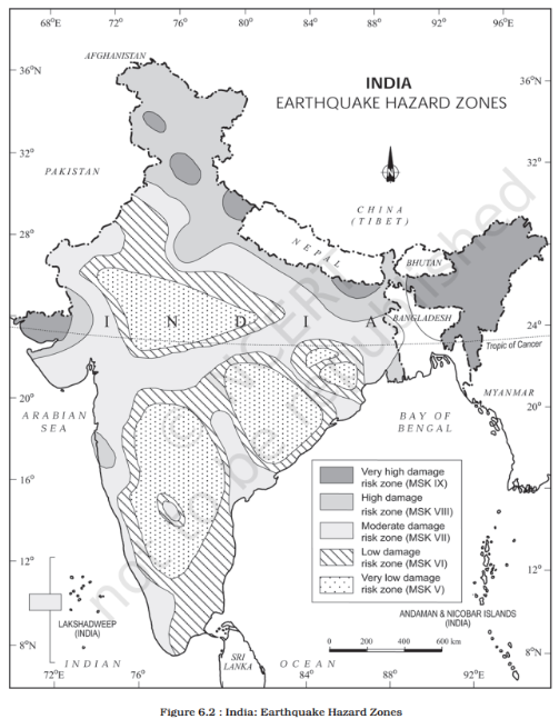
Earthquake Damage-Risk Zones
Basis and levels of zoning
- Assessment: The National Geophysical Laboratory, Geological Survey of India, Department of Meteorology, and National Institute of Disaster Management analysed more than earthquakes to classify India.
- Five zones: Very high, high, moderate, low, and very low damage risk.
- Risk pattern: The first two zones include some of India’s most devastating earthquake-affected areas.
| Risk zone | Areas described in the text |
|---|---|
| Very high | North-eastern states; areas north of Darbhanga and Araria along the Indo-Nepal border in Bihar; Uttarakhand; western Himachal Pradesh around Dharamshala; Kashmir Valley; Kuchchh (Gujarat) |
| High | Remaining parts of Jammu and Kashmir, Ladakh and Himachal Pradesh; northern Punjab; eastern Haryana; Delhi; western Uttar Pradesh; northern Bihar |
| Moderate to very low | Remaining parts of the country; many areas considered safer lie on the stable Deccan Plateau landmass |
Yokohama Strategy and Disaster Reduction
International disaster-reduction initiative
- May 23–27, 1994The World Conference on Natural Disaster Reduction met in Yokohama and adopted the Yokohama Strategy and Plan of Action for a Safer World.
- 1990–2000The decade was declared the International Decade for Natural Disaster Reduction (IDNDR).
Yokohama Strategy: key principles
- Rising losses: The conference recognised increasing human and economic losses and growing social vulnerability to disasters.
- Unequal impact: Poor and disadvantaged groups, especially in developing countries with limited capacity to cope, are affected most.
- National responsibility: Each country is sovereignly responsible for protecting its citizens from natural disasters.
- Priority: Give particular attention to developing countries, especially least-developed, land-locked, and small-island developing states.
- National preparedness: Strengthen national capacities, legislation, prevention, mitigation, and preparedness; involve NGOs and local communities.
- Cooperation: Strengthen sub-regional, regional, and international cooperation through capacity-building, technology and information sharing, and resource mobilisation.
- Tectonic earthquake
- An earthquake caused by sudden energy release during tectonic activity in the Earth’s crust.
- Damage-risk zone
- An area classified according to its relative risk of earthquake damage.
- Mitigation
- Measures taken to reduce disaster effects and losses.
- IDNDR
- International Decade for Natural Disaster Reduction, declared for 1990–2000.
How does movement of the Indian plate contribute to Himalayan earthquakes?
Name the five earthquake damage-risk zones used to classify India.
State the main priorities of the Yokohama Strategy.
Quick recap
- Natural disasters are broadly grouped into four categories; classification supports prompt identification and mitigation.
- India’s vast area, environmental and cultural diversity, social conditions, and large population contribute to disaster vulnerability.
- Earthquakes are highly unpredictable; tectonic earthquakes are often especially destructive and affect wide areas.
- Obstruction between the Indian and Eurasian plates builds stress that can be released as Himalayan earthquakes.
- India’s earthquake damage-risk zones range from very high to very low; many relatively safer areas lie on the stable Deccan Plateau.
- The Yokohama Strategy emphasised national responsibility, support for vulnerable countries, preparedness, and international cooperation.
Socio-Environmental Consequences of Earthquakes & Tsunami
Socio-Environmental Consequences of Earthquakes
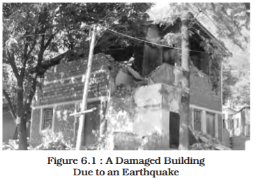
Earthquake calamity — An earthquake becomes a calamity when it strikes a densely populated area, causing widespread loss and disruption.
Social and economic effects
- Damage: Settlements, infrastructure, transport and communication networks, industries and other development activities may be damaged or destroyed.
- Displacement: People can lose homes and the material and socio-cultural gains built over generations.
- Economic strain: Homelessness adds pressure and stress, especially on the weak economies of developing countries.
| On the ground | On man-made structures | On water |
|---|---|---|
| Fissures | Cracking | Waves |
| Settlements | Sliding and overturning | Hydro-dynamic effects |
| Landslides | Buckling | Tsunamis |
| Liquefaction | Collapse | Possible chain effects |
| Earth-pressure collapse | Possible chain effects | |
| Chain effects |
Environmental consequences
- Surface seismic waves create fissures in the upper crust.
- Water and other volatile materials gush through fissures and inundate nearby areas.
- Earthquakes trigger landslides, which can block rivers and channels and form reservoirs.
- Rivers may change course, causing floods and other hazards.
Earthquake Hazard Mitigation
Earthquake mitigation — Because earthquakes cannot be prevented, preparedness and mitigation aim to reduce their effects before they occur.
Key preparedness measures
- Monitor and warn: Establish seismological centres for regular monitoring and rapid information sharing in vulnerable areas; GPS can help track tectonic-plate movement.
- Assess risk: Prepare vulnerability maps, share risk information and educate people about ways to reduce disaster impacts.
- Plan settlements: Adapt house types and building designs; discourage high-rise buildings, large industries and major urban centres in vulnerable areas.
- Build safely: Require earthquake-resistant designs and use light materials for major construction in vulnerable areas.
Tsunamis
Tsunami — A tsunami (harbour wave or seismic sea wave) is a series of high ocean waves caused by sudden displacement of seawater, commonly due to an earthquake or volcanic eruption that shifts the sea floor.
Formation and wave behaviour
- Wave series: The initial sea-floor disturbance creates a wave, followed by afterwaves that oscillate between crests and troughs as the water level is restored.
- In deep ocean: Tsunamis have very long wavelengths and limited wave heights; a ship may rise and fall only slightly over several minutes, so the waves can be difficult to detect.
- Near the coast: In shallow water, wavelength decreases while the period remains unchanged, increasing wave height; waves may reach 15 m or more.
- Shallow-water waves: Tsunamis are also called shallow-water waves because their destructive height grows as they approach shallow coastal waters.
Distribution and impacts
- Common region: Tsunamis are frequent around the Pacific Ring of Fire, including Alaska, Japan, the Philippines and Southeast Asian islands; they can also affect Indonesia, Malaysia, Myanmar, Sri Lanka and India.
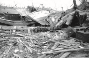
- Coastal destruction: On reaching land, turbulent water releases enormous energy, damaging port cities, towns, buildings, other structures and settlements.
- High human losses: Densely populated coasts are also centres of intense human activity, so tsunamis can cause exceptionally high loss of life and property.
Tsunami mitigation
- Tsunami impacts are difficult to mitigate because damage and losses can occur on a very large scale.
- No single state or government can manage the destruction alone.
- International cooperation and warning systems are therefore essential for dealing with tsunami risk.
Tsunami response
- 26 December 2004A major tsunami killed more than 300,000 people; India volunteered to join the International Tsunami Warning System afterward.
- Seismological centre
- A centre that monitors earthquakes and helps rapidly disseminate information.
- Afterwaves
- Waves that follow the initial tsunami disturbance as the water oscillates between crests and troughs.
- Vulnerability map
- A map identifying areas at risk so preparedness and mitigation can be planned.
Why can tsunamis be difficult to detect in the deep ocean but highly destructive near the coast?
List four measures that reduce earthquake risk.
Quick recap
- Earthquakes cause ground, structural and water-related effects, as well as major social and economic disruption.
- Fissures, landslides and river-course changes can lead to inundation, reservoirs and floods.
- Earthquakes cannot be prevented, so monitoring, risk awareness, safe planning and earthquake-resistant construction are vital.
- Tsunamis are waves caused by sudden displacement of seawater, commonly from earthquakes or volcanic eruptions.
- Tsunamis are relatively low and hard to detect in deep water but grow much taller near shallow coasts.
- Tsunami mitigation requires international cooperation and warning systems; the 2004 disaster killed more than 300,000 people.
Tropical Cyclone & Floods
Tropical Cyclones
| Condition | Why it matters |
|---|---|
| Continuous supply of warm, moist air | Provides moisture and latent heat. |
| Strong Coriolis force | Helps prevent the central low pressure from filling; its absence near the equator prevents formation between and latitude. |
| Tropospheric instability | Creates local disturbances around which a cyclone can develop. |
| Absence of strong vertical wind shear | Allows vertical transport of latent heat to continue. |
Cyclone Distribution in India
Seasonal Shift in Cyclone Origins
- JulyThe origin area shifts to around , west of , near the Sundarban Delta.
- October–NovemberBay of Bengal cyclones commonly develop between and , west of .
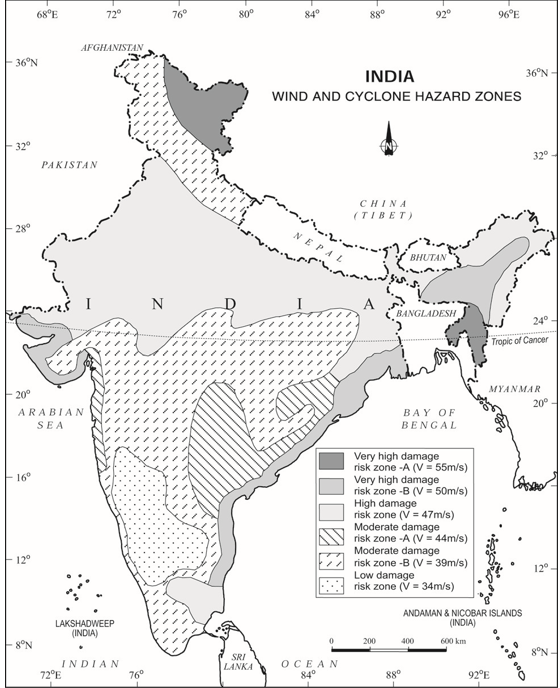
Wind and Cyclone Hazard Zones
| Risk class | Wind speed |
|---|---|
| Very high damage risk — A | |
| Very high damage risk — B | |
| High damage risk | |
| Moderate damage risk — A | |
| Moderate damage risk — B | |
| Low damage risk |
Consequences of Tropical Cyclones
- Coastal impact: Cyclones bring strong winds, heavy rain and storm surges, inundating settlements and agricultural fields.
- Damage: They destroy crops and human-made structures; their force generally decreases as they move inland.
Floods: Meaning and Causes
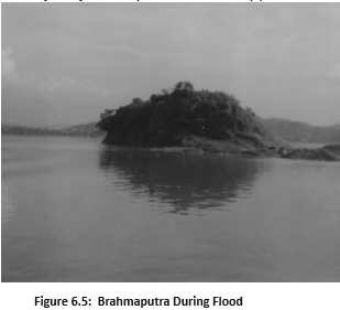
- Flood: Flooding occurs when water rises in river channels and spills over onto land and settlements.
- Causes: It may result from prolonged heavy rainfall, snow and ice melt, storm surges, reduced infiltration, or rivers exceeding their carrying capacity.
Flood Risk in India
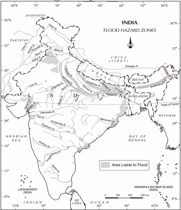
Flood Consequences and Control
- Latent heat
- Heat released when water vapour condenses; it supplies energy to tropical cyclones.
- Coriolis force
- A force associated with Earth's rotation that helps a cyclone maintain its circulation.
- Floodplain
- Low-lying land beside a river that may be inundated when the river overflows.
- Storm surge
- An abnormal rise in coastal sea level driven by a cyclone.
What conditions support the formation of a tropical cyclone?
Explain how a cyclone can cause coastal flooding.
State major human causes of increased flood severity and measures to reduce flood risk.
Quick recap
- Tropical cyclones form over warm tropical seas and draw energy from latent heat released during condensation.
- Warm, moist air, Coriolis force, tropospheric instability and the absence of strong vertical wind shear favour cyclone development.
- Indian cyclones originate over the Bay of Bengal and Arabian Sea; coastal regions, especially near Odisha and West Bengal, face higher wind and cyclone risk.
- Cyclones weaken inland; strong winds and pressure gradients can drive storm surges that inundate coasts.
- Flooding occurs when water exceeds the capacity of channels or inland water bodies; both natural and human factors contribute.
- Floods cause severe losses but can deposit fertile silt; control includes embankments, dams, afforestation and reducing human exposure.
Droughts
Meaning and Nature of Drought
- Drought: A prolonged shortage of available water caused by inadequate precipitation, excessive evaporation or overuse of stored and groundwater resources.
- Nature: Drought can affect people, agriculture and ecosystems, and its impacts may persist beyond the period of low rainfall.
Types of Drought
| Type | Main feature | Result / note |
|---|---|---|
| Meteorological | Prolonged inadequate rainfall, unevenly distributed across time and space. | A rainfall deficiency. |
| Agricultural (soil-moisture) | Soil moisture falls below the level needed to support crops. | May cause crop failure. Areas with over 30% of gross cropped area under irrigation are excluded from the drought-prone category. |
| Hydrological | Water in aquifers, lakes, reservoirs and other storages falls below the amount precipitation can replenish. | A shortage in stored water. |
| Ecological | Water shortage reduces the productivity of a natural ecosystem. | Ecological distress causes damage to the ecosystem. |
Drought-Prone Areas in India
National Extent and Causes
- Dependence on monsoon: Indian agriculture relies heavily on monsoon rainfall; droughts and floods are recurring features of India’s climate.
- Annual impact estimate: Nearly 19% of India’s geographical area and 12% of its population suffer from drought each year.
- Drought-prone estimate: About 30% of the country’s area is identified as drought-prone, affecting around 50 million people.
- Uneven monsoon: Large variations and unpredictability in monsoon behaviour mean floods may affect one region while drought affects another, or the same region in different seasons.
| Severity | Main regions |
|---|---|
| Extreme | Most of Rajasthan, especially west of the Aravalli Hills; the Marusthali region; and Kachchh in Gujarat. Jaisalmer and Barmer receive less than 90 mm of average annual rainfall. |
| Severe | Parts of eastern Rajasthan; most of Madhya Pradesh; eastern Maharashtra; interior Andhra Pradesh and the Karnataka Plateau; northern interior Tamil Nadu; southern Jharkhand; and interior Odisha. |
| Moderate | Northern Rajasthan; Haryana; southern Uttar Pradesh; the remaining parts of Gujarat; Maharashtra except Konkan; Jharkhand; the Coimbatore Plateau of Tamil Nadu; and interior Karnataka. |
| Free or less prone | The remaining parts of India. |
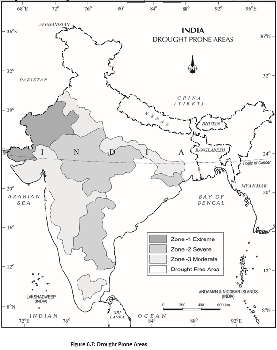
Consequences of Drought
- Akal
- Scarcity of food grains.
- Trinkal
- Scarcity of fodder.
- Jalkal
- Shortage of water.
- Trikal
- Scarcity of food grains, fodder and water together.
Drought’s Cascading Effects
- Water shortage and inadequate rainfall → crop failure and scarcity of food grains and fodder.
- Water and food shortages → death of cattle and other animals, and migration of people and livestock.
- Scarcity of safe water → use of contaminated water → waterborne diseases such as gastro-enteritis, cholera and hepatitis.
Planning and Mitigation
- Immediate relief: Provide safe drinking water, medicines, and water and fodder for cattle; move people and livestock to safer places when needed.
- Water-resource planning: Identify groundwater potential in aquifers and transfer river water from surplus to deficit areas.
- Long-term infrastructure: Consider interlinking rivers and constructing reservoirs and dams.
- Technology: Remote sensing and satellite imagery can help identify river basins for interlinking and assess groundwater potential.
- Drought-resistant crops: Share knowledge and train farmers to grow crops that can withstand drought.
- Rainwater harvesting: Harvesting rainwater can reduce the effects of drought.
Distinguish between the four types of drought.
Name key measures for drought relief and long-term mitigation.
Quick recap
- Drought is an extended water shortage linked to inadequate precipitation, excessive evaporation or overuse of stored water.
- The four types are meteorological, agricultural, hydrological and ecological drought.
- Nearly 19% of India’s area and 12% of its population are affected annually; about 30% of the area is drought-prone, affecting around 50 million people.
- Drought severity ranges from extreme in western Rajasthan and Kachchh to moderate across several other regions.
- Consequences include crop and fodder failure, water scarcity, animal deaths, migration and waterborne disease.
- Relief addresses immediate needs; mitigation includes water planning, drought-resistant crops and rainwater harvesting.
Landslides & Disaster Management
Landslides
Landslide — The rapid sliding of a large mass of bedrock down a slope.
Controls and monitoring
- Local controls: Geology, slope, geomorphic processes, land use, vegetation cover and human activities influence landslides.
- Monitoring: Highly localised controls make information-gathering and monitoring difficult and costly.
- Scale and impact: Direct effects are often localised, but landslides can severely affect the natural environment and national economy.
Landslide Vulnerability Zones
| Zone | Main conditions and areas |
|---|---|
| Very high vulnerability | Young, unstable Himalayan and Andaman and Nicobar mountain areas; steep, high-rainfall slopes of the Western Ghats and Nilgiris; north-eastern regions; earthquake-prone areas; and places with intensive construction, such as roads and dams. |
| High vulnerability | Areas with conditions similar to the very high zone, but with a different combination, intensity or frequency of controlling factors. Includes all Himalayan states and north-eastern states, except the plains of Assam. |
| Moderate to low vulnerability | Drier areas such as Ladakh and Spiti; stable but undulating Aravalli areas; rain-shadow areas of the Western and Eastern Ghats; and the Deccan Plateau. Occasional landslides still occur. |
| Mining- and subsidence-related landslides | Common in Jharkhand, Odisha, Chhattisgarh, Madhya Pradesh, Maharashtra, Andhra Pradesh, Karnataka, Tamil Nadu, Goa and Kerala. |
| Other areas | Generally safer areas include Rajasthan, Haryana, Uttar Pradesh, Bihar, West Bengal except Darjeeling, Assam except Karbi Anglong, and coastal regions of the southern states. |
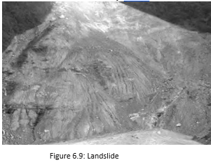
Consequences of Landslides
How landslides create wider impacts
- Rockfalls block roads, railway lines and river channels.
- Transport and spatial interaction become difficult, risky and costly.
- River-course diversions can trigger floods, causing loss of life and property.
- Disrupted movement and infrastructure hinder development in affected areas.
Landslide Mitigation
Area-specific measures
- Control development: Restrict construction and development, especially roads and dams, and limit large settlements in high-vulnerability zones.
- Manage land use: Limit agriculture to valleys and areas with moderate slopes.
- Stabilise slopes and water flow: Promote large-scale afforestation and build bunds to reduce water flow.
- Use suitable farming: Encourage terrace farming in north-eastern hill states where shifting cultivation (jhum) is practised.
Disaster Management
| Point | Cyclones | Earthquakes, tsunamis and volcanic eruptions |
|---|---|---|
| Predictability | More predictable in time and place. | Contrasted with cyclones as less predictable events. |
| Monitoring | Techniques can monitor intensity, direction and magnitude, allowing some management of the hazard. | Seismological centres monitor earthquakes; tsunami warning systems help alert coastal areas, though these hazards are difficult to predict. |
| Risk reduction | Shelters, embankments, dykes, reservoirs and afforestation to reduce wind speed can help minimise damage. | Earthquake-resistant construction and preparedness, tsunami warning systems and evacuation, and volcanic hazard monitoring and exclusion zones help reduce risk. |
Cyclone vulnerability
- Coastal exposure: Repeated losses of life and property in India, Bangladesh and Myanmar are linked largely to the high vulnerability of coastal populations.
- Preparedness: Cyclone shelters, embankments, dykes, reservoirs and afforestation can help minimise damage.
Disaster Management Bill, 2005
Disaster (as defined in the Bill) — A catastrophe, mishap, calamity or grave occurrence arising from natural or human causes, accident or negligence, which causes substantial loss of life or human suffering, or damage to or destruction of the environment, and is beyond the coping capacity of the affected community.
Key policy milestone
- 2005The Disaster Management Bill defined disaster; its introduction was identified as a positive step taken by the Government of India.
Stages of Disaster Mitigation and Management
| Stage | Main actions |
|---|---|
| Pre-disaster | Generate disaster information; prepare vulnerability maps; raise public awareness; plan, prepare and take preventive measures in vulnerable areas. |
| During disaster | Carry out rescue and relief urgently: evacuate people, set up shelters and relief camps, and supply water, food, clothing and medical aid. |
| Post-disaster | Rehabilitate and support recovery of victims; build capacity to cope with future disasters. |
Disasters and India's preparedness
- Hazards and disasters: Disasters may be natural or result from human activities; not every hazard becomes a disaster.
- Mitigation and preparedness: Since disasters—especially natural disasters—are difficult to eliminate, mitigation and preparedness are the next best options.
- Exposure: About two-thirds of India's geographical area and a similar proportion of its population are vulnerable to disasters.
- Government measures: The Disaster Management Bill, 2005, and establishment of the National Institute of Disaster Management are positive steps.
- Vulnerability zone
- An area classified by its likelihood of landslides, based on local controlling factors.
- Mitigation
- Measures that reduce the impacts of a hazard.
- Preparedness
- Planning and readiness to respond effectively when a disaster occurs.
- Rehabilitation
- Post-disaster support to help affected people recover.
Why are landslides difficult to monitor and predict?
State the three stages of disaster management and one key action in each.
Quick recap
- Landslides are rapid movements of bedrock controlled largely by local factors.
- India's landslide vulnerability ranges from very high to generally safer areas.
- Landslides can block transport routes, divert rivers and disrupt development.
- Mitigation includes regulating development, afforestation, bunds and terrace farming.
- Cyclones are comparatively predictable and can be managed partly through monitoring and protective measures.
- Disaster management involves preparation before, rescue and relief during, and recovery after a disaster.
- Disasters can be hard to eliminate, so mitigation and preparedness are essential.
Geography — ALL CHAPTERS
1
GEOGRAPHY AS A DISCIPLINE
2
THE ORIGIN AND EVOLUTION OF THE EARTH
3
INTERIOR OF THE EARTH
4
DISTRIBUTION OF OCEANS AND CONTINENTS
5
Geomorphic Processes
6
Landforms And Their Evolution
7
Composition And Structure Of Atmosphere
8
Solar Radiation, Heat Balance And Temperature
9
Atmospheric Circulation And Weather Systems
10
Water In The Atmosphere
11
World Climate And Climate Change
12
Water ( Oceans )
13
Movements Of Ocean Water
14
Biodiversity And Conservation
1
India - Location
2
Structure And Physiography
3
Drainage System
4
Climate
5
Natural Vegetation
6
Natural Hazards And Disasters