Class 11 Humanities . Geography . India Physical Environment . India Location
Chapter 1: India - Location
Ch 1
Geography
Class 11 Humanities
India - Location
India’s Extent and Territorial Limit
Geographical extent
- Mainland span: India extends from Kashmir in the north to Kanniyakumari in the south, and from Arunachal Pradesh in the east to Gujarat in the west.
- Southern boundary: India extends to in the Bay of Bengal.
- Territorial waters: India’s territorial limit extends nautical miles from the coast, about km.
- Distance units: One nautical mile is about km; one statute mile is about km.
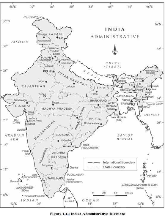
Effects of India’s Latitudinal and Longitudinal Extent
| Dimension | Extent / distance | Key implication |
|---|---|---|
| Latitudinal | Roughly ; north to south distance is km. | The south lies in the tropics; the north lies in the sub-tropical or warm temperate zone. |
| Longitudinal | Roughly ; east to west distance is km. | The eastern and western parts have a solar-time difference of nearly two hours. |
Why the ground distances differ
- Latitudes: The distance between two latitudes remains the same everywhere.
- Longitudes: The distance between two longitudes decreases towards the poles.
- Result: India’s north–south ground distance is greater than its east–west distance, although both angular extents are roughly .
- Regional variation: India’s latitudinal location contributes to major differences in landforms, climate, soils and natural vegetation.
Longitude and time in India
- India spans nearly of longitude.
- The Sun rises about two hours earlier in the north-eastern states than in Jaisalmer.
- Different places would otherwise have different local solar times.
- A single standard time is used so clocks across the country show the same time.
Indian Standard Time
Indian Standard Time (IST) — The common time used throughout India, based on the country’s standard meridian.
Standard meridian and time
- Standard meridian: Countries commonly select a standard meridian at a multiple of longitude.
- India’s meridian: is India’s standard meridian.
- IST and Greenwich: IST is hours minutes ahead of Greenwich Mean Time (GMT).
- Purpose: The standard meridian gives the whole country one uniform time despite differences in local solar time.
- Multiple time zones: Some countries with a vast east-to-west extent use more than one standard meridian; the USA has seven time zones.
India’s Area and Global Rank
- Area: India covers million sq. km, or of the world’s land surface.
- Rank: India is the world’s seventh-largest country by area.
- Territorial waters
- Sea area extending up to nautical miles from a country’s coast.
- Standard meridian
- The selected longitude used to set a country’s standard time.
- Indian Standard Time (IST)
- India’s uniform standard time, based on .
Why is India’s north–south distance greater than its east–west distance, although both angular extents are roughly ?
Why does India use as its standard meridian?
Quick recap
- India’s mainland spans Kashmir to Kanniyakumari and Gujarat to Arunachal Pradesh.
- India’s territorial waters extend nautical miles from its coast.
- India’s latitudinal and longitudinal extents are each roughly , but their ground distances differ.
- India’s location contributes to variations in landforms, climate, soils and natural vegetation.
- is India’s standard meridian; IST is hours minutes ahead of GMT.
- India covers million sq. km, about of world land area, and ranks seventh in size.
Size
India’s Size and Physical Diversity
Physical diversity — India’s large size supports a wide variety of landforms, rivers, forests and landscapes.
Indian subcontinent — A distinct geographic region of South Asia, bounded by major mountain ranges to the north and the Indian Ocean to the south.
Coastline and Maritime Location
Peninsular India and the Coast
- Mainland coastline: km.
- Total geographical coastline: km, including the mainland and the Andaman and Nicobar and Lakshadweep island groups.
- Island locations: Andaman and Nicobar lie in the Bay of Bengal; Lakshadweep lies in the Arabian Sea.
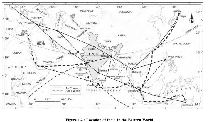
- Importance: India’s peninsular location and coastline provide links to neighbouring regions through sea and air routes.
- Resources: India’s varied physical features support the occurrence of diverse resources.
India and Its Neighbours
Location and Neighbouring Countries
- Location: India lies in the south-central part of Asia, bordering the Indian Ocean.
- Ocean arms: The Bay of Bengal lies to the east and the Arabian Sea to the west of Peninsular India.
- Land neighbours named in the lecture: Pakistan, Nepal, Bhutan and Bangladesh.
- Island neighbours: Sri Lanka and Maldives lie in the Indian Ocean.
- Sri Lanka: It is separated from India by the Gulf of Mannar and Palk Strait.
| Feature | Gulf | Strait |
|---|---|---|
| Meaning | A part of a sea or ocean that extends into the land. | A narrow water passage connecting larger water bodies and separating land areas. |
| Example near India | Gulf of Mannar | Palk Strait |
- Indian subcontinent
- A distinct South Asian geographic region bounded by mountain ranges and the Indian Ocean.
- Marusthali
- The vast sandy expanse in western India.
- Gulf
- A part of a sea or ocean extending into the land.
- Strait
- A narrow water passage connecting larger water bodies and separating land.
How does India’s size and location contribute to its significance?
Name India’s island neighbours and state how Sri Lanka is separated from India.
How do modern routes help India interact with neighbouring regions despite physical barriers?
Quick recap
- India’s large size supports varied landforms, rivers, forests and resources.
- Mountain ranges and the Indian Ocean define the boundaries of the Indian subcontinent.
- Mountain passes such as Khyber, Bolan, Shipkila, Nathula and Bomdila offered routes through the ranges.
- India has a 6,100 km mainland coastline and a 7,517 km total geographical coastline including island groups.
- India’s maritime location connects it with neighbouring regions through sea and air routes.
- Sri Lanka and Maldives are island neighbours; Sri Lanka is separated from India by the Gulf of Mannar and Palk Strait.
Geography — ALL CHAPTERS
1
GEOGRAPHY AS A DISCIPLINE
2
THE ORIGIN AND EVOLUTION OF THE EARTH
3
INTERIOR OF THE EARTH
4
DISTRIBUTION OF OCEANS AND CONTINENTS
5
Geomorphic Processes
6
Landforms And Their Evolution
7
Composition And Structure Of Atmosphere
8
Solar Radiation, Heat Balance And Temperature
9
Atmospheric Circulation And Weather Systems
10
Water In The Atmosphere
11
World Climate And Climate Change
12
Water ( Oceans )
13
Movements Of Ocean Water
14
Biodiversity And Conservation
1
India - Location
2
Structure And Physiography
3
Drainage System
4
Climate
5
Natural Vegetation
6
Natural Hazards And Disasters