Class 11 Humanities . Geography . Fundamental Of Physical Geography . Interior of the Earth
Chapter 3: INTERIOR OF THE EARTH
Ch 3
Geography
Class 11 Humanities
Sources of Information About the Interior
Why Study Earth's Interior?
- Limited access: Earth’s interior cannot be reached directly for observation or sampling; most knowledge comes from estimates and inferences.
- Earth’s radius: It is about 6,378 km.
- Landscape connection: Endogenic and exogenic processes shape the land surface; ignoring endogenic forces leaves our understanding of a region incomplete.
- Human relevance: Physiography affects human life, while interior processes help explain events such as earthquakes and tsunami generation.
- Layering: Earth-forming materials are arranged in layers from the crust to the core.
Direct Sources
Direct sources — Material obtained directly from Earth, such as rocks from the surface, mines, drilling, and volcanic eruptions.
- Surface and mine rocks: These are the most accessible solid materials. South African gold mines reach about 3–4 km; greater depths are difficult to explore because of intense heat.
- Deep drilling: The Deep Ocean Drilling Project and Integrated Ocean Drilling Project investigate deeper crustal conditions and collect material for analysis.
- Kola drilling: The deepest drill at Kola in the Arctic region had reached about 12 km, providing samples and information from depth.
- Volcanic material: Erupted magma can be analysed in laboratories, but its exact source depth is difficult to determine.
Indirect Sources
Indirect sources — Measurements and evidence used to infer the materials and conditions inside Earth without collecting them directly.
- Temperature, pressure, and density: Mining evidence shows that all three increase with depth. Their rates of change help scientists estimate conditions at different depths.
- Meteorites: Their material and structure are similar to those of Earth because they formed from the same or similar materials. They provide clues, though their analysed material is not from Earth’s interior.
- Gravity: The force of gravity, , varies across Earth. It is greater near the poles and lower at the equator because the equator is farther from Earth’s centre.
- Gravity anomalies: Differences between measured and expected gravity values can reveal uneven mass distribution in Earth’s crust; other factors can also affect readings.
- Magnetic surveys: These indicate the distribution of magnetic materials in the crust.
- Seismic activity: Seismic evidence is one of the most important sources of information about Earth’s interior.
| Point | Direct sources | Indirect sources |
|---|---|---|
| Evidence | Material collected from Earth, such as rocks and magma | Measurements or clues used to infer interior conditions |
| Examples | Mining, deep drilling, volcanic eruptions | Temperature, pressure and density trends; meteorites; gravity; magnetic surveys; seismic activity |
| Main limitation | Samples reach only shallow depths; magma’s source depth is uncertain | Interior properties must be inferred from indirect evidence |
Using Gravity to Infer Crustal Mass Distribution
- Uneven distribution of material inside Earth
- → Local differences in mass
- → Gravity readings differ from expected values
- → Gravity anomalies help identify crustal mass distribution
- Magma
- Molten material from within Earth that can reach the surface during a volcanic eruption.
- Gravity anomaly
- A difference between measured and expected gravity values at a location.
- Deep Ocean Drilling Project
- A project that drills into the ocean floor to investigate deeper crustal conditions.
- Integrated Ocean Drilling Project
- A project that collects deep-ocean drilling material to study Earth’s crust.
Why are most sources of information about Earth’s interior indirect?
What information do gravity anomalies provide?
Quick recap
- Earth’s interior is inaccessible, so most knowledge about it comes from indirect evidence.
- Surface rocks, mining, deep drilling, and volcanic magma are direct sources.
- South African gold mines reach about 3–4 km; Kola drilling reached about 12 km.
- Temperature, pressure, and density increase with depth.
- Meteorites, gravity, magnetic surveys, and seismic activity provide indirect clues.
- Gravity anomalies help reveal uneven mass distribution in the crust; seismic activity is a particularly important source.
Earthquake
Earthquake — A natural shaking of the Earth caused by the sudden release of energy, which produces waves travelling in all directions.
Why the Earth Shakes
Fault — A sharp break in crustal rocks along which rock blocks tend to move in opposite directions.
How an Earthquake Begins
- Rocks along a fault are pressed together; friction can lock them in place.
- Stress builds as the rocks continue trying to move.
- When stress overcomes friction, the deformed blocks suddenly slide past each other.
- The movement releases energy as waves that travel in all directions.
| Term | Meaning |
|---|---|
| Focus (hypocentre) | The point inside the Earth where earthquake energy is released. |
| Epicentre | The point on the surface directly above the focus; it is nearest to the focus and experiences the waves first. |
Earthquake Waves
Wave Basics
- Lithosphere: Natural earthquakes occur in the lithosphere, extending to about km below Earth's surface.
- Seismograph: An instrument that records earthquake waves arriving at the surface.
- Body waves: Begin at the focus and travel through Earth's interior in all directions.
- Surface waves: Form when body waves interact with surface rocks; they travel along the surface and are generally the most destructive.
- Wave speed: Waves travel faster through denser materials; their speed changes as they pass through materials of different densities.
- Wave paths: Waves may reflect or refract when they meet materials of different densities, changing their direction.
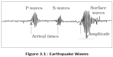
| Wave type | Movement and travel | Arrival and effects |
|---|---|---|
| Primary waves (-waves) | Body waves; similar to sound waves and travel through gases, liquids and solids. Vibrate parallel to the direction of travel. | Fastest waves; arrive first. Compress and stretch material, creating density differences. |
| Secondary waves (-waves) | Body waves; travel only through solids. Vibrate perpendicular to the direction of travel in a vertical plane. | Arrive after -waves and create troughs and crests. |
| Surface waves | Travel along Earth's surface and vibrate perpendicular to their direction of propagation. | Arrive last; cause rock displacement and are the most damaging, often leading to structural collapse. |
Reflection and Refraction
- Reflection: A wave rebounds when it meets a boundary.
- Refraction: A wave changes direction as it passes through materials with different densities.
- Evidence: Seismograph records help reveal changes in wave direction and travel through Earth's interior.
Shadow Zones
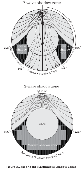
Shadow zone — An area where earthquake waves from a particular quake are not recorded by seismographs.
| Wave | Observed pattern relative to the epicentre | Shadow zone |
|---|---|---|
| -waves | Recorded within and again beyond . | A band between and from the epicentre. |
| -waves | Recorded within ; not recorded beyond that distance. | The entire region beyond , covering a little over of Earth's surface. |
Types of Earthquakes
| Type | Cause or setting |
|---|---|
| Tectonic | Rocks slide along a fault plane; this is the most common type. |
| Volcanic | A special class of tectonic earthquake, confined to areas of active volcanoes. |
| Collapse | Underground mine roofs collapse, causing minor tremors in areas of intense mining. |
| Explosion | Ground shaking caused by explosions of chemical or nuclear devices. |
| Reservoir-induced | Earthquakes occurring in areas of large reservoirs. |
Measuring Earthquakes
| Point | Magnitude | Intensity |
|---|---|---|
| Scale | Richter scale; expressed from to . | Mercalli scale, named after Italian seismologist Mercalli; ranges from to . |
| Measures | Energy released during the earthquake. | Visible damage caused by the earthquake. |
Effects of Earthquakes
Immediate Hazards
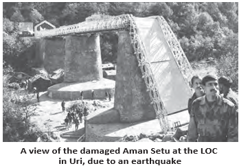
- Landform-related effects: Ground shaking, differential ground settlement, landslides and mudslides, soil liquefaction, ground lurching, and avalanches.
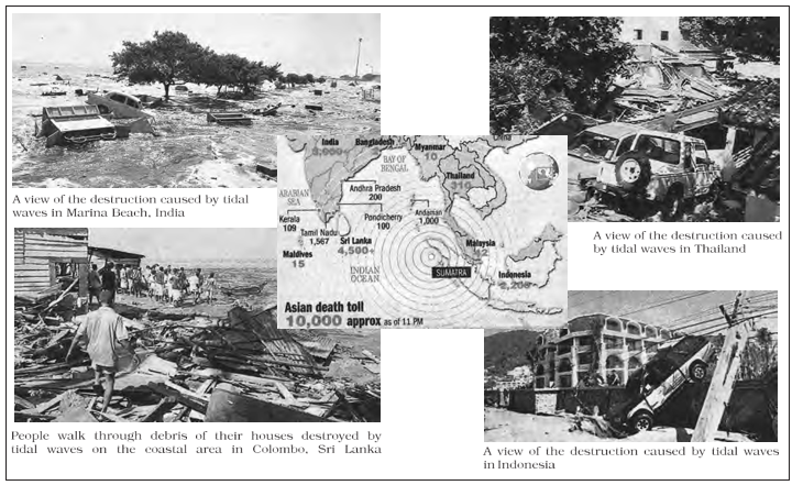
- Other immediate hazards: Ground displacement, floods from dam or levee failure, fires, structural collapse, falling objects, and tsunamis.
- Tsunami condition: A tsunami may occur if the epicentre is beneath ocean waters and the earthquake magnitude is sufficiently high.
- Tsunami: Waves generated by earthquake tremors; a tsunami is not itself an earthquake.
- Impact: Shaking lasts only seconds, but earthquakes above magnitude can have devastating effects on people and property.
Frequency of Earthquake Occurrences
- High-magnitude quakes: Magnitude earthquakes are rare, occurring about once every – years.
- Tiny tremors: Occur almost every minute.
- Risk: Strong tremors can cause severe loss of life and property, but major shocks do not affect all parts of the world equally.
How do the focus and epicentre differ?
Why are -waves important for understanding Earth's interior?
What is the difference between magnitude and intensity?
Quick recap
- Earthquakes result from sudden energy release, commonly when rocks slip along a fault.
- The focus is underground; the epicentre lies directly above it on the surface.
- -waves arrive first and travel through solids, liquids and gases; -waves travel only through solids.
- Wave speed increases in denser material; surface waves arrive last, travel along the surface and are highly destructive.
- Wave shadow zones and the absence of -waves provide evidence about Earth's interior.
- Earthquakes include tectonic, volcanic, collapse, explosion and reservoir-induced types; Richter magnitude measures energy, while Mercalli intensity describes visible damage.
- Earthquake hazards include ground and structural damage, fires, floods, landslides and, under suitable conditions, tsunamis.
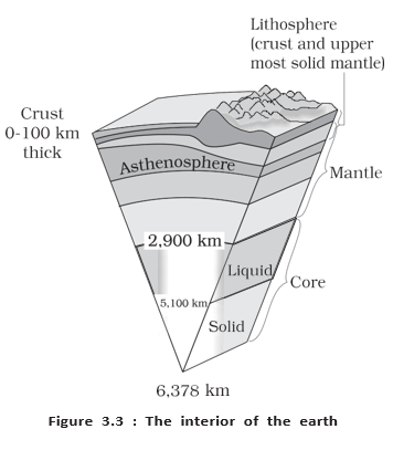
Structure of the Earth
Layers of the Earth
| Layer or zone | Extent and thickness | State and key features |
|---|---|---|
| Crust | Outermost layer; oceanic crust averages about 5 km and continental crust about 30 km | Solid and brittle; continental crust reaches about 70 km beneath the Himalayas |
| Mantle | Extends from the Moho discontinuity to a depth of about 2,900 km | Includes the asthenosphere and lower mantle |
| Asthenosphere | Weak upper part of the mantle, extending to about 400 km | Main source of magma that can rise to the surface |
| Lithosphere | Crust plus the uppermost mantle; about 10–200 km thick | The solid outer layer |
| Lower mantle | Extends below the asthenosphere | Solid state |
| Core | Begins at the core–mantle boundary, about 2,900 km deep | Outer core is liquid; inner core is solid; mainly nickel and iron |
Mantle and Core: Key Points
- Moho discontinuity: Marks the boundary between the crust and the mantle.
- Mantle: The layer below the crust is denser than the crust.
- Core evidence: Earthquake-wave velocities helped reveal the existence of Earth’s core.
- Nife: The core is sometimes called the nife layer because it consists mainly of nickel and iron.
Volcanoes and Volcanic Materials
Volcano — A volcano is a place where gases, ash and/or molten rock escape to the ground.
Volcanic Materials
- Active volcano: One that is erupting or has released materials in the recent past.
- Magma: Molten rock material in the upper mantle.
- Lava: Magma that moves towards the crust or reaches Earth’s surface.
- Eruptive materials: Lava flows, pyroclastic debris, volcanic bombs, ash, dust and gases.
- Gases: May include nitrogen and sulphur compounds, with smaller amounts of chlorine, hydrogen and argon.
| Point | Magma | Lava |
|---|---|---|
| Meaning | Molten rock below Earth’s surface, in the upper mantle | Magma moving towards or reaching Earth’s surface |
Major Types of Volcanoes
- Classification: Volcanoes are classified by the nature of their eruptions and the landforms they produce.
| Type | Eruption and landform | Example or key feature |
|---|---|---|
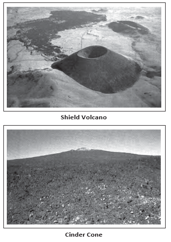
| Shield volcano | Mainly fluid basalt lava spreads widely, forming broad, gentle slopes; generally low-explosivity, but water entering the vent can make eruptions explosive | Among the largest volcanoes on Earth, apart from flood basalt flows; Hawaiian volcanoes are famous examples |
| Cinder cone | A lava fountain throws material around the top of a vent, building a cone | Can develop during shield-volcano activity |
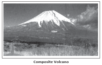
| Composite volcano | Cooler, more viscous lava, pyroclastic material and ash build layers near the vent; eruptions are often explosive | Layered volcanic mounts |
| Caldera | A highly explosive eruption may cause the volcano to collapse inwards, forming a depression | Indicates a huge magma chamber close to the surface |
| Flood basalt province | Highly fluid lava spreads over vast areas in repeated flows; some flows exceed 50 m thick and extend hundreds of kilometres | Deccan Traps cover much of the Maharashtra plateau today; they once covered a larger area |
| Mid-ocean ridge volcano | Frequent eruptions occur along the central part of oceanic ridges | The ridge system extends for more than 70,000 km through all ocean basins |
- Moho discontinuity
- Boundary between the crust and the mantle.
- Asthenosphere
- Weak upper part of the mantle and a major source of magma.
- Lithosphere
- The crust together with the uppermost mantle.
- Pyroclastic debris
- Fragmented volcanic material ejected during eruptions.
Differentiate between magma and lava.
Why are shield volcanoes generally not steep?
What is a caldera?
Quick recap
- Crust: The brittle outer layer is thinner beneath oceans than continents; it averages about 5 km under oceans and 30 km under continents.
- Mantle: Extends from the Moho discontinuity to about 2,900 km; its asthenosphere reaches about 400 km and the lower mantle is solid.
- Lithosphere and core: The lithosphere is the crust plus uppermost mantle; the outer core is liquid and the inner core is solid, mainly nickel and iron.
- Volcanic materials: Magma is molten rock below the surface; it is called lava as it moves towards or reaches the surface.
- Shield volcanoes: Fluid basalt forms gentle slopes; shield volcanoes are among Earth’s largest, apart from flood basalt flows.
- Other volcano types: Composite volcanoes, calderas, flood basalt provinces and mid-ocean ridge volcanoes differ in eruption style and landform.
Volcanic Landforms
Intrusive Forms
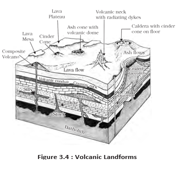
Major Intrusive Forms
| Point | Sheet | Sill |
|---|---|---|
| Orientation | Near-horizontal | Near-horizontal |
| Thickness | Thinner intrusive deposit | Thicker intrusive deposit |
- Denudation
- Processes that wear away and remove overlying material, exposing deeper rocks.
- Magma chamber
- An underground reservoir of magma; its cooled portion may form a batholith.
- Feeder
- A conduit through which magma rises towards the surface.
How do batholiths and lacoliths differ?
What are dykes, and where are they significant in India?
Quick recap
- Magma cooling at the surface forms volcanic rocks; cooling within the crust forms plutonic rocks and intrusive forms.
- Batholiths are large, deep granitic bodies; denudation can expose them.
- Lacoliths are dome-shaped, while lapoliths are saucer-shaped intrusions.
- Phacoliths are wavy intrusions associated with synclines and anticlines.
- Sheets and sills are near-horizontal intrusions; sheets are thinner than sills.
- Dykes fill cracks, are common in western Maharashtra and fed eruptions that formed the Deccan Traps.
Geography — ALL CHAPTERS
1
GEOGRAPHY AS A DISCIPLINE
2
THE ORIGIN AND EVOLUTION OF THE EARTH
3
INTERIOR OF THE EARTH
4
DISTRIBUTION OF OCEANS AND CONTINENTS
5
Geomorphic Processes
6
Landforms And Their Evolution
7
Composition And Structure Of Atmosphere
8
Solar Radiation, Heat Balance And Temperature
9
Atmospheric Circulation And Weather Systems
10
Water In The Atmosphere
11
World Climate And Climate Change
12
Water ( Oceans )
13
Movements Of Ocean Water
14
Biodiversity And Conservation
1
India - Location
2
Structure And Physiography
3
Drainage System
4
Climate
5
Natural Vegetation
6
Natural Hazards And Disasters