Class 11 Humanities . Geography . Fundamental Of Physical Geography . Distribution of Oceans and Continents
Chapter 4: DISTRIBUTION OF OCEANS AND CONTINENTS
Ch 4
Geography
Class 11 Humanities
Introduction & Continental Drift
Changing Positions of Continents and Oceans
The changing Earth
- Present distribution: Continents cover about 29% of Earth’s surface; the rest is covered by oceans.
- Change over time: Continents and oceans have not always occupied their present positions, and their positions will continue to change.
Continental Drift
Continental drift theory — Alfred Wegener’s theory that continents were once joined and later drifted apart.
The theory
- Wegener’s proposal: In 1912, German meteorologist Alfred Wegener presented a comprehensive theory about the distribution of continents and oceans.
- Pangaea: All continents once formed one supercontinent, meaning “all earth.”
- Panthalassa: A vast ocean surrounded Pangaea; its name means “all water.”
- Break-up: Around 200 million years ago, Pangaea split into Laurasia in the north and Gondwanaland in the south; these later divided into today’s continents.
Key dates and periods
- Around 200 million years agoPangaea began to split into Laurasia and Gondwanaland.
- 1596Dutch map maker Abraham Ortelius first proposed that some continents may once have been joined.
- 1912Alfred Wegener presented the continental drift theory.
- 1964Bullard presented a computer-based best-fit map of the Atlantic margins.
Early ideas
- Coastline resemblance: Similar Atlantic coastlines prompted the idea that the Americas, Europe and Africa may once have been connected.
- Antonio Pellegrini: Drew a map showing three continents joined together.
Evidence Supporting Continental Drift
| Evidence | Observation | Significance |
|---|---|---|
| Jig-saw fit of continents | The facing coastlines of Africa and South America match remarkably well. Bullard’s 1964 computer-based fit used the 1,000-fathom line rather than modern shorelines. | The close fit supports the idea that the continents were once joined. |
| Rocks of the same age | Ancient rocks about 2,000 million years old on Brazil’s coast match rocks in western Africa. The earliest marine deposits along both coastlines are Jurassic in age. | The matching rocks support former connection; the marine deposits suggest the ocean did not exist before that time. |
| Tillite | Tillite is sedimentary rock formed from glacial deposits. Gondwana sediments in India have counterparts in Africa, the Falkland Islands, Madagascar, Antarctica and Australia. | The thick basal tillite indicates prolonged glaciation; similar sediments point to shared histories, past climates and continental drift. |
| Placer deposits | Gold placer deposits occur on the Ghana coast, but their source rock is absent there. Gold-bearing veins occur in Brazil. | The gold was likely carried from the Brazil plateau when Brazil and Ghana lay side by side. |
| Fossils | Lemurs occur in India, Madagascar and Africa. Mesosaurus fossils occur in South Africa’s Southern Cape province and Brazil’s Iraver formations, now about 4,800 km apart. | Matching land and freshwater species across ocean barriers are difficult to explain unless the landmasses were once connected. |
Clues from fossils and glacial deposits
- Lemuria: The distribution of lemurs led some scholars to propose a former landmass linking India, Madagascar and Africa.
- Mesosaurus: This small reptile lived in shallow brackish water; its fossils on both sides of the Atlantic support a past land connection.
Forces Proposed for Continental Drift
| Force | Cause | Wegener’s idea |
|---|---|---|
| Pole-fleeing force | Earth’s rotation, which produces an equatorial bulge because Earth is not a perfect sphere. | Could help move continents away from the poles. |
| Tidal force | The gravitational attraction of the Moon and the Sun, which produces ocean tides. | Could act on continents over millions of years. |
Scientific assessment
- Limitation: Wegener thought the forces could become effective over millions of years, but most scholars considered them far too weak to cause continental drift.
- Pangaea
- The supercontinent that once contained all continents.
- Panthalassa
- The mega-ocean surrounding Pangaea.
- Laurasia
- The northern continental mass formed when Pangaea split.
- Gondwanaland
- The southern continental mass formed when Pangaea split.
- Tillite
- Sedimentary rock formed from glacial deposits.
What were Pangaea and Panthalassa?
State three types of evidence for continental drift.
Which forces did Wegener suggest caused continental drift, and what was the main criticism?
Quick recap
- Continents cover about 29% of Earth’s surface, and their positions change over time.
- Wegener proposed that Pangaea, surrounded by Panthalassa, split into northern Laurasia and southern Gondwanaland.
- Evidence includes coastline fit, matching rocks, Gondwana tillite, placer deposits and fossil distributions.
- Wegener suggested pole-fleeing and tidal forces, but scholars considered them too weak.
- The present separation of matching fossils and geological features supports former continental connections.
Post-drift Studies
New Evidence After Continental Drift
Key Developments
- 1930sArthur Holmes discussed mantle convection currents as a possible force behind continental movement.
- Post–World War II periodOcean-floor expeditions and research provided detailed information about ocean relief.
- 1961Hess proposed the sea-floor spreading hypothesis.
Convection Current Theory
- Convection currents: Holmes proposed that thermal differences in the mantle, generated by radioactive elements, set up currents throughout the mantle.
- Significance: This theory offered a possible explanation for the force driving continental movement.
Mapping the Ocean Floor
- Ocean-floor relief: Mapping showed that the ocean floor is not a flat plain; it includes submerged mountain ranges and deep trenches.
- Oceanic crust: Mid-ocean ridges are active volcanic zones, and rocks on either side of their crests show similar ages and composition.
Major Divisions of the Ocean Floor
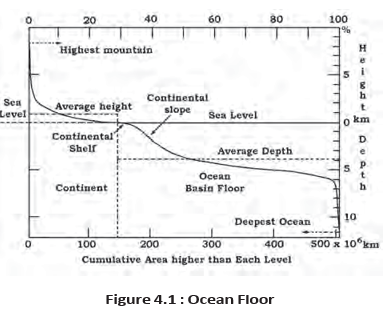
Continental Margins, Abyssal Plains and Ridges
- Continental margins: These are transition zones between continental shores and deep-sea basins.
- Abyssal plains: Extensive plains where sediments carried beyond continental margins are deposited.
- Mid-ocean ridges: Submerged mountain chains with central rifts marked by intense volcanic activity.
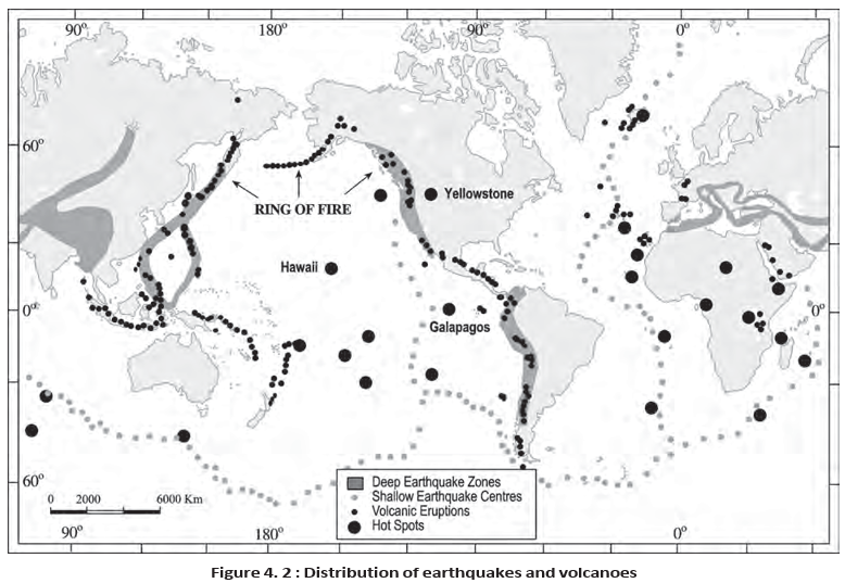
Distribution of Earthquakes and Volcanoes
Sea-Floor Spreading
- Basic idea: Sea-floor spreading is the continuous formation and outward movement of oceanic crust from mid-ocean ridges.
- Crustal recycling: New lava pushes older oceanic crust away from ridges; the crust eventually sinks at deep-ocean trenches and is consumed.
Evidence for Sea-Floor Spreading
How the Ocean Floor Spreads and Is Recycled
- Volcanic eruptions at ridge crests bring lava to the surface.
- Lava enters ruptures in the oceanic crust and forms new crust.
- New crust pushes older oceanic crust away from the ridge on both sides.
- The moving crust sinks at deep-oceanic trenches and is consumed.
- Continental margin
- Transition between continental shores and deep-sea basins.
- Abyssal plain
- Extensive plain between continental margins and mid-oceanic ridges where sediments accumulate.
- Mid-oceanic ridge
- Submerged mountain chain with an intensely volcanic central rift.
- Sea-floor spreading
- Formation of new oceanic crust at ridges, its outward movement and consumption at trenches.
What evidence supports sea-floor spreading?
Quick recap
- Holmes proposed that radioactive heating generates mantle convection currents that could help move continents.
- The ocean floor has three major divisions: continental margins, deep-sea basins and mid-oceanic ridges.
- Abyssal plains collect sediments carried beyond continental margins.
- Earthquakes and volcanoes concentrate along ridges, the Alpine-Himalayan belt and the Pacific Ring of Fire; the map also shows hotspots.
- Hess’s 1961 hypothesis describes new crust forming at ridges, moving outward and sinking at trenches.
- Oceanic rocks and sediments are no older than 200 million years, much younger than some continental rocks.
Plate Tectonics
Development of Plate Tectonics
- 1967McKenzie and Parker, and independently Morgan, brought together existing ideas to propose plate tectonics; interest had revived after the concept of sea-floor spreading.
Tectonic Plates and Their Distribution
Tectonic plate — A massive, irregular slab of solid lithosphere that moves horizontally over the asthenosphere as a rigid unit.
Plate Structure and Movement
- Lithosphere: Includes the crust and the upper mantle; its thickness is about 5–100 km beneath oceans and about 200 km beneath continents.
- Composition: A plate generally contains both continental and oceanic lithosphere.
- Naming: A plate is called continental or oceanic according to which type of lithosphere occupies the larger part; the Eurasian Plate is largely continental, while the Pacific Plate is largely oceanic.
- Boundaries: Major plates are commonly bordered by young fold mountains, ridges, trenches and/or faults.
| Plate | Extent or distinguishing detail |
|---|---|
| Antarctic Plate | Antarctica and the surrounding oceanic area |
| North American Plate | Includes the western Atlantic floor; separated from the South American Plate along the Caribbean islands |
| South American Plate | Includes the western Atlantic floor; separated from the North American Plate along the Caribbean islands |
| Pacific Plate | A largely oceanic plate |
| India–Australia–New Zealand Plate | Includes the Indian, Australian and New Zealand regions |
| African Plate | Includes the eastern Atlantic floor |
| Eurasian Plate | Includes adjacent oceanic areas; largely continental |
| Plate | Location |
|---|---|
| Cocos Plate | Between Central America and the Pacific Plate |
| Nazca Plate | Between South America and the Pacific Plate |
| Arabian Plate | Mostly under the Saudi Arabian landmass |
| Philippine Plate | Between the Asiatic and Pacific plates |
| Caroline Plate | Between the Philippine and Indian plates, north of New Guinea |
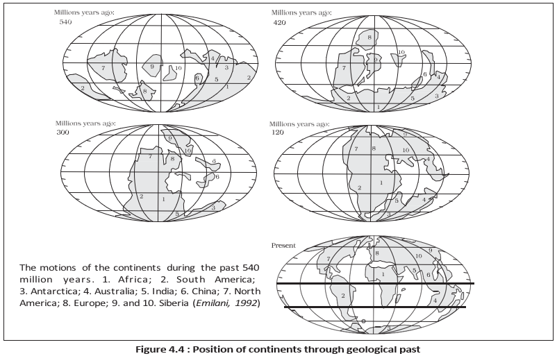
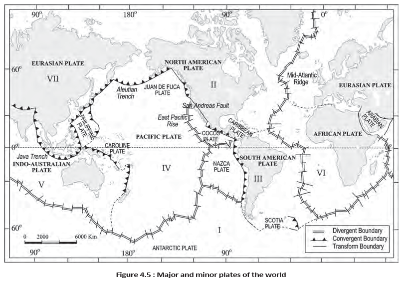
Plate Movement and Continental Positions
Continents Move as Parts of Plates
- What moves: Plates move across the globe; continents are carried as parts of plates rather than moving independently.
- Continuing movement: All plates have moved in the geological past and are expected to keep moving.
- Pangaea: Wegener proposed that continents once formed the supercontinent Pangaea. Later discoveries indicate that Pangaea formed when continental masses on different plates converged.
- Reconstructing the past: Scientists use palaeomagnetic data to determine the former positions of present-day continental landmasses.
- India: The past position of the Indian subcontinent, especially Peninsular India, has been traced using rocks analysed from the Nagpur area.
Types of Plate Boundaries
| Boundary type | Plate movement | Effect on crust | Key term or example |
|---|---|---|---|
| Divergent | Plates pull apart | New crust is generated | Spreading site; the Mid-Atlantic Ridge separates the American plates from the Eurasian and African plates |
| Convergent | Plates move towards one another; one may sink beneath another | Crust is destroyed at the subduction zone | Convergence may occur between oceanic–continental, oceanic–oceanic or continental–continental plates |
| Transform | Plates slide horizontally past one another | Crust is neither produced nor destroyed | Transform faults commonly lie perpendicular to mid-oceanic ridges |
Transform Boundary Details
- Uneven ridge activity: Eruptions do not occur along an entire ridge crest at the same time, contributing to differential movement of plate portions away from Earth's axis.
- Rotation: Earth's rotation also affects the movement of separated plate blocks.
- Lithosphere
- The crust and upper mantle, divided into tectonic plates.
- Asthenosphere
- The layer over which lithospheric plates move horizontally.
- Spreading site
- A divergent boundary where plates move apart and new crust forms.
- Subduction zone
- A convergent boundary where one plate sinks beneath another.
- Transform fault
- A fault along which plates slide horizontally past one another.
How do the three types of plate boundaries differ in their effect on crust?
What evidence is used to trace the former positions of continents and the Indian subcontinent?
Quick recap
- Plate tectonics was proposed in 1967 by McKenzie and Parker, and independently by Morgan.
- Plates are rigid lithospheric slabs that move over the asthenosphere; continents move as parts of plates.
- Earth has seven major plates and several minor plates, including Cocos, Nazca, Arabian, Philippine and Caroline.
- Palaeomagnetic data help reconstruct past continental positions; Nagpur rocks help trace India's past position.
- Divergent boundaries generate crust, convergent boundaries destroy it, and transform boundaries conserve it.
Rates of Plate Movement & Movement Of The Indian Plate
Rates of Plate Movement
- Measurement: Strips of normal and reversed magnetic polarity parallel to mid-ocean ridges help determine plate movement rates.
- Variation: Rates differ widely, from less than 2.5 cm per year at the Arctic Ridge to more than 15 cm per year at the East Pacific Rise near Easter Island.
Force for Plate Movement
Convective Flow
- Heat inside Earth warms mantle material.
- Hot, softened material rises toward the surface and spreads beneath the plates.
- It cools, becomes denser, and sinks into deeper mantle layers.
- The cycle repeats, helping move the plates.
Movement of the Indian Plate
Indian Plate: Movement and Major Events
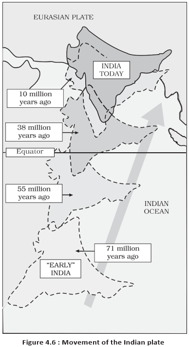
- About 225 million years agoIndia was a large island off the Australian coast, separated from Asia by the Tethys Sea.
- About 200 million years agoIndia began moving north as Pangaea broke apart.
- About 140 million years agoThe Indian subcontinent lay near 50°S; the Tethys Sea separated it from the Eurasian plate, while the Tibetan block was closer to the Asiatic landmass.
- About 71 million years ago to the presentThe Indian plate continued its northward movement towards the Eurasian plate.
- Around 60 million years agoLava outpouring began, forming the Deccan Traps; this continued for a long period while India was still near the equator.
- About 40–50 million years agoIndia collided with Asia, causing rapid uplift of the Himalayas.
- From about 40 million years ago to the presentHimalayan formation continued; scientists believe the process is ongoing and the mountains are still rising.
Indian Plate Collision and Himalayan Uplift
- The Indian plate moved north towards the Eurasian plate.
- The plates collided about 40–50 million years ago.
- The collision caused rapid uplift and formation of the Himalayas.
- The process continues, and the Himalayas are still rising.
- Convection cell
- A repeated circular flow of mantle material: rising, spreading, cooling, and sinking.
- Tethys Sea
- The sea that separated India from the Asian continent before the Indian plate's northward movement brought the plates together.
- Deccan Traps
- A vast lava formation produced by prolonged lava outpouring around 60 million years ago.
Quick recap
- Magnetic strips parallel to mid-oceanic ridges help estimate plate movement rates.
- The Arctic Ridge is slowest (<2.5 cm/yr); the East Pacific Rise is fastest (>15 cm/yr).
- Mantle convection, powered by radioactive decay and residual heat, drives plate movement.
- The Indian plate includes Peninsular India and Australian continental portions and has convergent and spreading boundaries.
- India began moving north about 200 million years ago and collided with Asia about 40–50 million years ago.
- The Deccan Traps formed from lava outpouring around 60 million years ago; Himalayan uplift continues today.
Geography — ALL CHAPTERS
1
GEOGRAPHY AS A DISCIPLINE
2
THE ORIGIN AND EVOLUTION OF THE EARTH
3
INTERIOR OF THE EARTH
4
DISTRIBUTION OF OCEANS AND CONTINENTS
5
Geomorphic Processes
6
Landforms And Their Evolution
7
Composition And Structure Of Atmosphere
8
Solar Radiation, Heat Balance And Temperature
9
Atmospheric Circulation And Weather Systems
10
Water In The Atmosphere
11
World Climate And Climate Change
12
Water ( Oceans )
13
Movements Of Ocean Water
14
Biodiversity And Conservation
1
India - Location
2
Structure And Physiography
3
Drainage System
4
Climate
5
Natural Vegetation
6
Natural Hazards And Disasters