Class 11 Humanities . Geography . Fundamental Of Physical Geography . Movements of Ocean Water
Chapter 13: Movements Of Ocean Water
Ch 13
Geography
Class 11 Humanities
Introduction & Waves
Ocean-Water Movements
What drives ocean-water movement?
- Ocean water is dynamic: Temperature, salinity and density, along with forces from the Sun, Moon and winds, influence its movement.
- Horizontal movement: Includes ocean currents and waves.
- Vertical movement: Includes tides—the rise and fall of ocean water—as well as upwelling of cold subsurface water and sinking of surface water.
| Point | Ocean currents | Waves |
|---|---|---|
| Movement | A continuous flow of a large amount of water in a definite direction. | Wave trains move across the surface; water particles mainly move in small circles. |
| What travels onward? | Water moves from one place to another. | Energy travels across the ocean; the water itself does not travel forward with the wave. |
Vertical Movement: Tides
- Tides: The Sun’s and Moon’s attraction raises and lowers ocean water; this rise and fall occurs twice a day.
- Other vertical movements: Cold water may rise from below the surface, while surface water may sink.
Waves
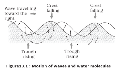
Wave — A wave is energy moving across the ocean surface; water particles mainly move in small circular paths as it passes.
How Waves Form and Move
- Wind supplies energy: Most waves form when wind drives against the water; stronger winds can build small ripples into breaking waves with white caps.
- Wave motion: Wind pushes water forward while gravity pulls the crests down. Falling water lifts the former troughs, shifting the wave onward.
- Water-particle motion: Particles move up and forward as a wave approaches, then down and back as it passes.
- Breeze: A breeze of two knots or less over calm water can produce small ripples.
- Deep water: Surface-wave motion seldom affects the stagnant water at the deep ocean bottom.
Wave Growth, Travel and Breaking
- Growth: Waves can grow larger as they travel and absorb energy from the wind; the largest waves are found in the open oceans.
- Maximum height: Depends on wind strength, how long the wind blows, and the distance over which it blows in one direction.
- Travel distance: Waves may travel thousands of kilometres before breaking and dissolving as surf at the shore.
- Approaching shore: A wave slows because of friction between moving water and the sea floor.
- Breaking condition: A wave breaks when water depth becomes less than half its wavelength.
| Wave appearance | Likely origin |
|---|---|
| Steep waves | Fairly young waves, probably formed by local wind. |
| Slow and steady waves | Waves that have travelled from far away, possibly from another hemisphere. |
Characteristics of Waves
| Characteristic | Meaning |
|---|---|
| Crest | The highest point of a wave. |
| Trough | The lowest point of a wave. |
| Wave height | The vertical distance from the bottom of a trough to the top of a crest. |
| Wave amplitude | One-half of the wave height. |
| Wave period | The time between successive crests or troughs passing a fixed point. |
| Wavelength | The horizontal distance between two successive crests. |
| Wave speed | The rate at which a wave moves through water; measured in knots. |
| Wave frequency | The number of waves passing a given point in one second. |
How does wave motion differ from the movement of ocean water in a current?
Quick recap
- Ocean-water movement is horizontal (currents and waves) or vertical (tides, upwelling and sinking).
- Currents carry water; waves mainly carry energy while particles move in small circles.
- Wind generates waves; wave height depends on wind strength, duration and the distance it blows in one direction.
- The largest waves occur in open oceans; waves slow near shore through sea-floor friction and break when depth is less than half their wavelength.
- Crests and troughs are the highest and lowest points; amplitude is half the wave height.
- Period, wavelength, speed and frequency describe wave timing, spacing and movement.
Tides
Tides and Surges
Surge — A rise or fall of water caused by meteorological effects such as winds and changes in atmospheric pressure; unlike tides, surges are irregular.
Causes and Formation of Tidal Bulges
How tidal bulges form
- Main cause: The Moon’s gravitational pull is the strongest influence; the Sun’s pull also contributes, but to a lesser extent.
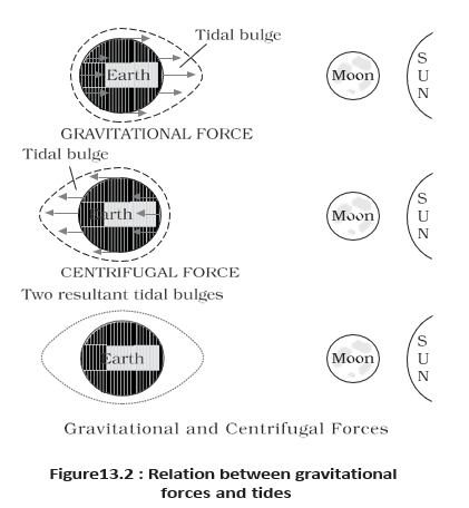
- Centrifugal force: Acts in opposition to gravity and, together with lunar attraction, produces two tidal bulges on opposite sides of Earth.
- Near side: The Moon’s attraction exceeds the centrifugal force, creating a net force towards the Moon and a bulge in that direction.
- Far side: The Moon’s attraction is weaker because this side is farther away; centrifugal force dominates, producing a bulge away from the Moon.
- Tide-generating force: The difference between the Moon’s gravitational attraction and centrifugal force. Horizontal tide-generating forces are more important than vertical forces in forming the bulges.
Factors Affecting Tidal Height and Currents
Local effects
- Continental shelves: Tidal bulges have greater height over wide continental shelves.
- Mid-oceanic islands: Tidal bulges become lower when they encounter these islands.
- Coastline shape: Bays and estuaries can magnify tides; funnel-shaped bays can greatly change their magnitude.
- Tidal currents: Tides channelled between islands or into bays and estuaries form tidal currents.
Bay of Fundy: Highest Tides
- Location: The world’s highest tides occur in the Bay of Fundy, Nova Scotia, Canada.
- Tidal range: The tidal bulge reaches about –.
- Rapid rise: With two high and two low tides in roughly hours, the incoming tide takes about six hours. A steep coastal cliff makes it especially important to watch the tide.
Using a rise of over about six hours gives a rough rate of per hour.
Types of Tides by Frequency
| Type | Pattern in a day | Key feature |
|---|---|---|
| Semi-diurnal | Two high tides and two low tides | Most common pattern; successive high tides and successive low tides are approximately equal in height. |
| Diurnal | One high tide and one low tide | Successive high and low tides are approximately equal in height. |
| Mixed | Tides differ in height | Common on the west coast of North America and many Pacific islands. |
Tides by Sun–Moon–Earth Position
| Type | Positions and forces | Result and timing |
|---|---|---|
| Spring tide | Sun, Moon and Earth lie in a straight line; their effects reinforce each other. | Higher-than-usual tides; occur twice a month, at the full Moon and new Moon. |
| Neap tide | Sun and Moon are at right angles to Earth; their effects tend to counteract each other. | Smaller tidal range; usually about seven days after a spring tide. The Moon’s attraction is more than twice the Sun’s, but the Sun’s opposing pull reduces the effect. |
| Position | Meaning | Effect on tidal range |
|---|---|---|
| Perigee | Moon is closest to Earth, once a month. | Unusually high and low tides; range is greater than normal. |
| Apogee | Moon is farthest from Earth, about two weeks after perigee. | The Moon’s gravitational force is weaker; tidal range is below average. |
| Perihelion | Earth is closest to the Sun, around 3 January each year. | Tidal ranges are greater, with unusually high and low tides. |
| Aphelion | Earth is farthest from the Sun, around 4 July each year. | Tidal ranges are below average. |
Ebb and Flow
| Point | Ebb | Flow (flood) |
|---|---|---|
| Water level | Falls from high tide towards low tide. | Rises from low tide towards high tide. |
| Meaning | The interval during which the tide is falling. | The interval during which the tide is rising. |
What causes the two tidal bulges on Earth?
Distinguish between spring tides and neap tides.
What is the difference between ebb and flow?
Quick recap
- Tides are periodic sea-level changes mainly caused by the Moon’s and Sun’s gravitational attraction; surges are irregular and meteorological.
- Gravitational and centrifugal forces create two tidal bulges; horizontal tide-generating forces are especially important.
- Wide shelves and funnel-shaped bays can increase tidal height, while mid-oceanic islands can reduce it.
- Semi-diurnal, diurnal and mixed tides differ in the number and relative heights of daily tides.
- Spring tides occur at full and new Moon; neap tides occur when the Sun and Moon are at right angles.
- Perigee and perihelion increase tidal ranges; apogee and aphelion reduce them. Ebb falls; flow or flood rises.
Importance Of Tides And Ocean Currents
Importance of Tides
Tides — Tides are predictable changes in sea level caused by the positions of Earth, the Moon and the Sun.
Uses of Tides
- Planning: Advance prediction helps navigators and fishermen plan their activities.
- Navigation: Tidal flows and heights help ships enter harbours, especially river and estuary harbours where shallow bars can obstruct entry.
- Estuaries: Tides help remove sediment and flush polluted water from river estuaries.
- Electricity: Tidal power is used in Canada, France, Russia and China.
- India: A 3 MW tidal power project at Durgaduani in the Sundarbans of West Bengal is under way.
Ocean Currents: Meaning and Causes
Ocean current — A regular volume of ocean water moving along a definite path and in a definite direction.
Forces Influencing Currents
- Force groups: Primary forces initiate water movement; secondary forces influence currents as they flow.
- Solar heating: Water expands when heated. Near the equator, the ocean surface is about 8 cm higher than in middle latitudes, creating a slight slope down which water tends to flow.
- Wind: Wind pushes surface water; friction between wind and water affects the water's movement.
- Gravity: Gravity pulls piled-up water down and creates variations in the water-level gradient.
- Coriolis force: It deflects moving water to the right in the Northern Hemisphere and to the left in the Southern Hemisphere.
Gyres and Density-Driven Movement
- Large accumulations of ocean water form → water flows around them in large circular currents called gyres.
- High salinity or low temperature increases water density → denser water sinks while relatively lighter water rises.
- Cold polar water sinks and slowly moves towards the equator → warm surface water flows from the equator towards the poles to replace it.
Characteristics of Ocean Currents
| Feature | Meaning / characteristic |
|---|---|
| Drift | The speed of a current, measured in knots. |
| Strength | A faster current is stronger; currents are usually strongest near the surface and weaken with depth. |
| Surface speed | Currents may exceed 5 knots near the surface. |
| Deep speed | Deep currents are generally slower than 0.5 knots. |
| Typical speed | Most currents have speeds of 5 knots or less. |
Types of Ocean Currents
| Type | Extent / share | Movement |
|---|---|---|
| Surface currents | Upper 400 m; about 10% of ocean water | Flow mainly in the upper ocean. |
| Deep-water currents | About 90% of ocean water | Move through ocean basins due to density and gravity; water sinks at cold, high latitudes. |
| Type | What it carries | Common coastal location |
|---|---|---|
| Cold currents | Cold water into warmer areas | Usually west coasts in low and middle latitudes in both hemispheres; also east coasts in higher latitudes of the Northern Hemisphere. |
| Warm currents | Warm water into colder areas | Usually east coasts in low and middle latitudes in both hemispheres; also west coasts in higher latitudes of the Northern Hemisphere. |
Major Ocean Currents and Circulation
Circulation Patterns
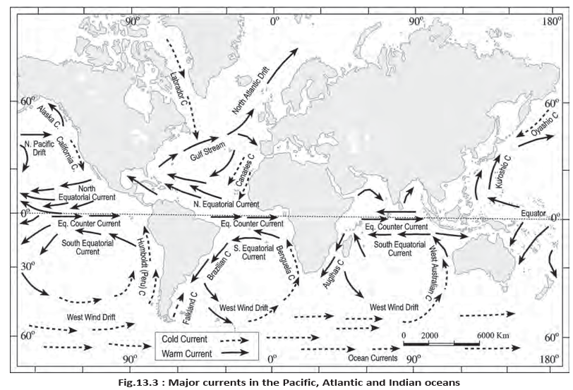
- Main influences: Prevailing wind stresses and the Coriolis force strongly influence major ocean currents.
- Atmospheric link: Ocean circulation broadly follows atmospheric circulation; middle-latitude circulation is mainly anticyclonic, more pronounced in the Southern Hemisphere than in the Northern Hemisphere.
- Higher latitudes: Winds and ocean circulation are mostly cyclonic.
- Monsoons: In areas with pronounced monsoon flow, monsoon winds influence current movement.
- Deflection: Warm currents from low latitudes tend to move right in the Northern Hemisphere and left in the Southern Hemisphere due to the Coriolis force.
Ocean Currents Redistribute Heat
- Cold waters from the Arctic and Antarctic circles move towards warmer tropical and equatorial regions.
- Warm waters from lower latitudes move polewards.
- Ocean circulation transfers heat between latitude belts, similarly to the general circulation of the atmosphere.
Effects of Ocean Currents
| Location / process | Current effect | Result |
|---|---|---|
| West coasts in tropical and subtropical latitudes, except near the equator | Cool waters border the coasts. | Relatively low average temperatures, narrow daily and annual temperature ranges, fog, and generally arid conditions. |
| West coasts in middle and higher latitudes | Warm waters border the coasts. | Marine climate with cool summers, relatively mild winters and a narrow annual temperature range. |
| East coasts in tropical and subtropical latitudes | Warm currents flow parallel to the coasts. | Warm and rainy climates; these areas lie on the western margins of subtropical anticyclones. |
| Zones where warm and cold currents mix | Mixing replenishes oxygen and favours plankton growth. | Plankton feed fish, so these zones contain some of the world's best fishing grounds. |
- Gyre
- A large circular current formed by water flowing around an accumulation.
- Drift
- The speed of a current, measured in knots.
- Plankton
- Organisms that form the primary food source for fish.
How do tides help navigation and harbour use?
How do ocean currents redistribute heat?
Why are warm–cold current mixing zones productive fishing grounds?
Quick recap
- Tides are predictable and support navigation, estuary cleaning and electricity generation.
- Solar heating, wind, gravity and the Coriolis force are primary influences on currents.
- Gyres are large circular currents; dense, cold or salty water tends to sink.
- Surface currents occupy the upper 400 m and about 10% of ocean water; deep currents account for about 90%.
- Ocean circulation broadly follows atmospheric circulation; middle-latitude anticyclonic circulation is stronger in the Southern Hemisphere.
- Currents redistribute heat and influence coastal climates; mixing zones support plankton, fish and productive fisheries.
Geography — ALL CHAPTERS
1
GEOGRAPHY AS A DISCIPLINE
2
THE ORIGIN AND EVOLUTION OF THE EARTH
3
INTERIOR OF THE EARTH
4
DISTRIBUTION OF OCEANS AND CONTINENTS
5
Geomorphic Processes
6
Landforms And Their Evolution
7
Composition And Structure Of Atmosphere
8
Solar Radiation, Heat Balance And Temperature
9
Atmospheric Circulation And Weather Systems
10
Water In The Atmosphere
11
World Climate And Climate Change
12
Water ( Oceans )
13
Movements Of Ocean Water
14
Biodiversity And Conservation
1
India - Location
2
Structure And Physiography
3
Drainage System
4
Climate
5
Natural Vegetation
6
Natural Hazards And Disasters