Class 11 Humanities . Geography . India Physical Environment . Climate
Chapter 4: Climate
Ch 4
Geography
Class 11 Humanities
Unity And Diversity In The Monsoon Climate
Weather, Climate and the Monsoon
- Weather: The momentary state of the atmosphere; it can change quickly.
- Climate: The average weather conditions of a place over a long period.
- Monsoon: A climate associated with the seasonal reversal of wind direction; India has a hot monsoonal climate.
Unity and Regional Diversity
- Despite strong regional differences, India's climate remains monsoonal in rhythm and character.
Factors Determining India's Climate
- Climate controls: India’s climate is shaped by its location, physical features and relationship with surrounding land and seas.
- Regional effects: These controls influence temperature, pressure, winds and the distribution of rainfall across the country.
Inter-Tropical Convergence Zone and Monsoon Winds
Seasonal Shift of the ITCZ
- In summer, the ITCZ shifts north to the Gangetic Plain → a monsoon trough and thermal low develop over northern and northwestern India.
- Southern Hemisphere trade winds cross the equator → the Coriolis force turns them into southwesterly winds → southwest monsoon.
- In winter, the ITCZ moves south → winds reverse direction → northeast monsoon.
- Equable climate
- A climate with relatively small temperature contrasts, often due to the sea's moderating influence.
- Thermal low
- A low-pressure area formed when strong heating warms the air above a region.
- Windward side
- The side of a mountain facing incoming winds; it often receives more rainfall.
- Leeward side
- The sheltered side away from incoming winds; it is often drier.
- Monsoon trough
- The northward-shifted ITCZ that lies near the Gangetic Plain in July.
Quick recap
- Weather is short-term; climate is the long-term average of weather conditions.
- The monsoon climate is unified by seasonal wind reversal but varies greatly from region to region.
- India's temperature and rainfall differ with latitude, relief, altitude, distance from the sea, land–water heating and the Himalayas.
- Coasts are generally more temperature-moderated than inland regions; altitude and relief also shape local climate.
- The northward summer shift of the ITCZ helps form the southwest monsoon; its winter shift southward is linked to the northeast monsoon.
The Nature Of Indian Monsoon
Understanding the Indian Monsoon
Why the monsoon is studied
- Complex system: The monsoon has been observed for centuries, but its exact nature and causes remain difficult to explain.
- Global perspective: Studying rainfall causes across South Asia and the wider global system has improved understanding.
- Key features: The onset and breaks in monsoon rainfall are important aspects of its behaviour.
Onset of the Monsoon
Southwest monsoon — The seasonal winds that cross the Equator from the southeast and reach the Indian subcontinent from the southwest.
Traditional explanation of monsoon onset
- In April and May, the sun heats the northern landmass intensely while the Indian Ocean warms more slowly.
- The heated land develops intense low pressure over the northwestern subcontinent; pressure remains relatively high over the southern Indian Ocean.
- The low-pressure area draws southeast trade winds across the Equator, where they are deflected towards India as southwest monsoon winds.
- The movement of these winds is associated with the northward shift of the Inter-Tropical Convergence Zone (ITCZ).
- The winds cross the Equator between longitudes and .
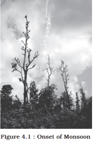
Jet streams and onset
- Westerly jet: Its withdrawal from above the north Indian plain, south of the Himalayas, is linked to the northward shift of the ITCZ.
- Easterly jet: It sets in along after the westerly jet withdraws.
- Monsoon burst: The easterly jet stream is considered responsible for the burst of the monsoon in India.
Usual advance of the southwest monsoon
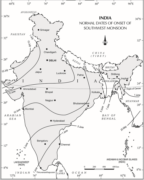
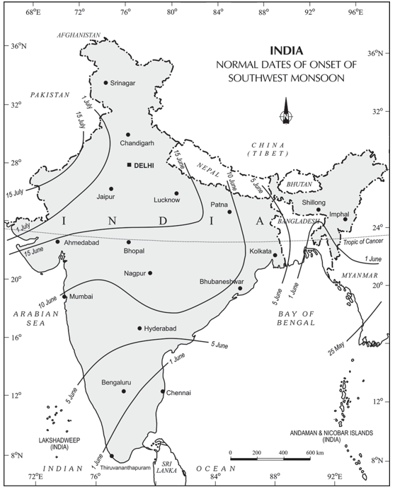
- 1 JuneThe monsoon normally sets in over the Kerala coast.
- 10–13 JuneIt reaches Mumbai and Kolkata.
- Mid-JulyIt usually covers the entire subcontinent.
Break in the Monsoon
Break in the monsoon — A dry spell of one or more weeks during the southwest monsoon, after rain has occurred for a few days.
| Region | Cause of dry spell |
|---|---|
| Northern India | Rain may fail when rain-bearing storms occur infrequently along the monsoon trough or ITCZ. |
| West coast | Dry spells are associated with days when winds blow parallel to the coast. |
The Rhythm of Seasons
Four recognised seasons
- Annual cycle: India's climate is described through a recurring cycle of seasons.
- Seasons: Cold weather; hot weather; southwest monsoon; and retreating monsoon.
The Cold Weather Season
Temperature and regional contrasts
- Northern India: The cold season generally begins by mid-November; December and January are the coldest months in the northern plains.
- Cold conditions: Mean daily temperatures stay below over much of northern India. Nights can fall below freezing in Punjab and Rajasthan.
- Continental effect: Punjab, Haryana and Rajasthan are far from the sea's moderating influence, so they experience a continental climate.
- Himalayan effect: Snowfall in nearby ranges contributes to cold-wave conditions.
- Late-winter cold waves: Around February, winds from the Caspian Sea and Turkmenistan can bring frost and fog to northwestern India.
- Peninsular India: It has no clearly defined cold season; coastal temperatures vary little because of the sea and proximity to the Equator.
- Example: Thiruvananthapuram's mean maximum temperature is about in January and in June; Western Ghats hill temperatures remain comparatively low.
Understanding the Monsoon
Observation and forecasting
- Data sources: Monsoon mechanisms are studied using observations from land, oceans and the upper atmosphere.
- Southern Oscillation indicator: The pressure difference between Tahiti, in the eastern Pacific, and Port Darwin, in northern Australia, is one measure used to assess monsoon-related conditions.
- Locations: Tahiti is near ; Port Darwin is near .
- Forecasting: The India Meteorological Department (IMD) uses 16 indicators to forecast likely monsoon behaviour.
Pressure and Winds in the Cold Season
Pressure pattern and wind direction
- Solar position: Around 22 December, the Sun is vertical over the Tropic of Capricorn in the Southern Hemisphere.
- Pressure pattern: A weak high-pressure area forms over the northern plains, while pressure is slightly lower in southern India.
- Isobars: The mb isobar crosses northwestern India and the mb isobar crosses the far south.
- Outward winds: A weak pressure gradient drives light winds, around km/h, from the northwestern high-pressure zone towards lower pressure over the Indian Ocean.
- Wind direction: Winds are westerly or northwesterly down the Ganga Valley, northerly in the Ganga–Brahmaputra delta, and northeasterly over the Bay of Bengal.
Western disturbances in winter
- Shallow cyclonic depressions originate over the eastern Mediterranean Sea.
- They travel east across West Asia, Iran, Afghanistan and Pakistan.
- They reach northwestern India, gaining moisture from the Caspian Sea to the north and the Persian Gulf to the south.
Winter Rainfall
Why winter monsoon winds bring little rain
- General pattern: Winter winds blow from land towards the sea, carry little humidity and are associated with anticyclonic circulation over land; therefore, most of India receives little or no winter rain.
- Northwest rain: Weak temperate cyclones from the Mediterranean bring rain to Punjab, Haryana, Delhi and western Uttar Pradesh.
- Importance: This small amount of rain benefits rabi crops. Snowfall in the lower Himalayas helps sustain Himalayan river flow during summer.
- Rainfall gradient: In the plains, winter precipitation decreases from west to east; in the mountains, it decreases from north to south.
- Examples: Average winter rainfall is about mm in Delhi, mm in Punjab and mm in Bihar.
| Area or season | Rainfall pattern |
|---|---|
| Central India and northern parts of the southern Peninsula | Occasional winter rainfall. |
| Arunachal Pradesh and Assam | About mm of rain during the winter months. |
| Northeast monsoon, October–November | Crosses the Bay of Bengal, picks up moisture and brings torrential rain to the Tamil Nadu coast, southern Andhra Pradesh, southeast Karnataka and southeast Kerala. |
El Niño and the Indian Monsoon
El Niño — A recurring ocean–atmosphere event, usually appearing every three to seven years, involving unusually warm water off Peru in the eastern Pacific.
Development and effects
- Current change: El Niño is an extension of the warm equatorial current; it temporarily replaces the cold Peruvian (Humboldt) Current.
- Coastal warming: The event can raise water temperature off Peru by about .
- Weather impacts: It distorts equatorial atmospheric circulation and causes irregularities in seawater evaporation; it can bring droughts, floods and other weather extremes worldwide.
- Marine impact: Reduced plankton can lead to fewer fish in the sea.
- Name: “El Niño” means “Child Christ”; the current appears around Christmas in December, which is summer in Peru.
El Niño and monsoon forecasting
- 1990–91A strong El Niño event occurred, and the southwest monsoon onset was delayed by five to twelve days across most of India.
What is a break in the monsoon, and what causes it in northern India?
Why does northwestern India receive winter rainfall, and why is it useful?
What is El Niño, and how can it affect the Indian monsoon?
Quick recap
- The southwest monsoon is linked to differential land–sea heating, the northward shift of the ITCZ and changes in jet streams.
- It normally reaches Kerala around 1 June, Mumbai and Kolkata around 10–13 June, and covers India by mid-July.
- Monsoon breaks are dry spells; their causes differ between northern India and the west coast.
- India has four recognised seasons; winter is coldest in the northern plains but less distinct in peninsular coastal areas.
- Winter winds are generally dry, but western disturbances and the northeast monsoon bring rainfall to particular regions.
- El Niño recurs every three to seven years and can influence extreme weather and the timing of the Indian monsoon.
The Hot Weather Season
Temperature Patterns
Seasonal temperatures
- Northward solar movement: As the sun appears to move towards the Tropic of Cancer in March, temperatures begin rising in northern India; April, May and June are summer months there.
- North India: Most areas record . The heat belt shifts north as summer advances.
- Highest temperatures: The Deccan Plateau reaches about in March; Gujarat and Madhya Pradesh record in April; north-western India may reach about in May.
- South India: The peninsula and surrounding oceans moderate heat; temperatures generally remain . Western Ghats hill temperatures stay below because of altitude.
- Coastal pattern: Isotherms run broadly parallel to the coast; temperatures increase from the coast towards the interior rather than decreasing from north to south.
- Summer nights: Mean daily minimum temperatures remain high and rarely fall below .
| Point | North India | South India |
|---|---|---|
| Heat | Intense; north-west may reach about in May. | Milder because of the peninsula’s ocean-moderating influence. |
| Typical temperatures | Most areas: . | Generally ; Western Ghats hills below . |
Pressure, Winds and Local Weather
Formation of the Monsoon Trough
- Strong summer heating raises temperatures and lowers air pressure over northern India.
- The ITCZ shifts northward, reaching a position centred near in July.
- An elongated low-pressure monsoon trough extends from the Thar Desert in the north-west to Patna and the Chotanagpur Plateau in the east-south-east.
- The trough attracts surface winds towards it and helps shape the monsoon circulation.
Surface winds and pre-monsoon weather
- Wind directions: Winds are south-westerly along the west coast and the coasts of West Bengal and Bangladesh; they are easterly or south-easterly over north Bengal and Bihar.
- Origin of monsoon currents: These south-westerly monsoon winds are displaced equatorial easterlies. By mid-June, their arrival signals a shift towards rainy-season weather.
- Loo: Hot, dry, oppressive winds blow in the afternoons across the northern plains, from Punjab to Bihar; they may continue until midnight.
- Dust storms: Common on May evenings in Punjab, Haryana, eastern Rajasthan and Uttar Pradesh. They can bring light rain and a cool breeze, briefly relieving the heat.
- Local intense storms: When moist air meets dry air near the trough, violent winds, torrential rain and sometimes hailstorms may occur.
| Phenomenon | Where and when | Key feature or effect |
|---|---|---|
| Mango showers | Kerala and coastal Karnataka, near the end of summer | Pre-monsoon showers that help mangoes ripen early. |
| Blossom showers | Kerala and nearby areas | Rain that helps coffee flowers blossom. |
| Nor’westers | Evening thunderstorms in Bengal and Assam | Called Kalbaisakhi in Bengal and Bardoisila in Assam; useful for tea, jute and rice cultivation. |
| Loo | Northern plains, from Punjab to Bihar | Hot, dry and oppressive winds, especially in the afternoon. |
Onset of the Southwest Monsoon
How the Southwest Monsoon Develops
- Rapid heating over the north-western plains in May intensifies low-pressure conditions.
- By early June, the low pressure is strong enough to attract Southern Hemisphere south-east trade winds from the Indian Ocean.
- The winds cross the equator, pass over warm equatorial currents and gather abundant moisture.
- After crossing the equator, they turn south-westerly and are known as the southwest monsoon.
Burst of the monsoon — The sudden onset of moisture-laden monsoon winds, often accompanied by violent thunder and lightning, is called the burst of the monsoon.
Onset and temperature change
- First effect: The first monsoon rain substantially lowers temperatures.
- Coastal onset: The monsoon may burst over Kerala, Karnataka, Goa and Maharashtra in the first week of June.
- Interior onset: It may reach inland parts of the country only in the first week of July.
- Temperature fall: Day temperatures typically decline by between mid-June and mid-July.
- Two branches: Relief and local pressure patterns split the monsoon into the Arabian Sea branch and the Bay of Bengal branch.
Seasonal Timing
- MarchTemperatures rise in northern India; the Deccan Plateau may record about .
- AprilGujarat and Madhya Pradesh may record .
- MayThe heat belt shifts north; north-western India may reach about , and low pressure intensifies.
- Early JuneThe southwest monsoon may burst over the western coastal states and begins to be drawn towards the north-western low pressure.
- Mid-June to mid-JulyDay temperatures fall by as monsoon conditions develop.
- First week of JulyThe monsoon may reach interior parts of India; the ITCZ is centred near in July.
Arabian Sea Branch
| Path | Route and rainfall | Outcome |
|---|---|---|
| Western Ghats path | Winds rise over the Western Ghats from about ; the windward Sahyadris and Western Coastal Plain receive about of rain. | Descending winds warm and lose humidity, creating a rain-shadow area with little rainfall east of the Ghats. |
| Narmada–Tapi path | Winds strike the coast north of Mumbai, then travel along the Narmada and Tapi valleys across central India. | The Chotanagpur Plateau receives about from this branch; the winds then enter the Ganga plains and meet the Bay of Bengal branch. |
| Saurashtra–Kachchh path | Winds strike the Saurashtra Peninsula and Kachchh, then pass over west Rajasthan and along the Aravalis. | They bring scanty rainfall; in Punjab and Haryana this branch joins the Bay of Bengal branch. |
Rainfall in the Western Himalayas
- Arabian Sea branch travels through the Narmada–Tapi route or across Saurashtra and Kachchh.
- The branches join the Bay of Bengal branch over the Ganga plains or Punjab and Haryana.
- The combined winds are reinforced and bring rain to the western Himalayas.
- ITCZ
- The zone of convergence that shifts northward in summer and is associated with the monsoon trough.
- Monsoon trough
- An elongated low-pressure zone extending from the Thar Desert towards Patna and the Chotanagpur Plateau.
- Loo
- Hot, dry and oppressive winds that blow over the northern plains in the hot season.
- Rain-shadow area
- An area of low rainfall on the leeward side of a mountain range, such as east of the Western Ghats.
Why is the hot weather season milder in south India than in north India?
What causes heavy rain on the western slopes of the Western Ghats and low rainfall east of them?
Quick recap
- Summer heat advances northward, while the peninsula and oceans make south India milder.
- The northward-shifting ITCZ forms a low-pressure trough that attracts surface winds.
- Loo, dust storms and local thunderstorms are characteristic hot-season weather phenomena.
- The southwest monsoon forms when moisture-bearing south-east trade winds cross the equator and turn south-westerly.
- The monsoon bursts first in coastal areas and later reaches the interior, lowering day temperatures.
- The Arabian Sea branch splits into three paths, producing heavy windward rainfall, rain-shadow conditions and rainfall farther north.
Monsoon Winds of the Bay of Bengal
Bay of Bengal Branch of the Monsoon
- Route: The Bay of Bengal branch strikes Myanmar and southeast Bangladesh; the Arakan Hills deflect much of it towards India.
- Branches: It enters West Bengal and Bangladesh from the south and southeast, then splits—one branch moves west along the Ganga plains, the other up the Brahmaputra valley.
- Meghalaya rainfall: A sub-branch strikes the Garo and Khasi hills; Mawsynram on the Khasi Hills receives the world’s highest average annual rainfall.
- Tamil Nadu coast: It remains relatively dry because it lies parallel to the Bay of Bengal branch and in the rain shadow of the Arabian Sea branch.
Geography — ALL CHAPTERS
1
GEOGRAPHY AS A DISCIPLINE
2
THE ORIGIN AND EVOLUTION OF THE EARTH
3
INTERIOR OF THE EARTH
4
DISTRIBUTION OF OCEANS AND CONTINENTS
5
Geomorphic Processes
6
Landforms And Their Evolution
7
Composition And Structure Of Atmosphere
8
Solar Radiation, Heat Balance And Temperature
9
Atmospheric Circulation And Weather Systems
10
Water In The Atmosphere
11
World Climate And Climate Change
12
Water ( Oceans )
13
Movements Of Ocean Water
14
Biodiversity And Conservation
1
India - Location
2
Structure And Physiography
3
Drainage System
4
Climate
5
Natural Vegetation
6
Natural Hazards And Disasters