Class 7 . Social Science . Exploring Society India and Beyond Part I . Climates of India
Chapter 3: Climates of India
Ch 3
Social Science
Class 7
Weather, Seasons and the Climate
Weather, Climate and Seasons
Climate — The long-term pattern of weather experienced by an area or region over several decades or more.
How Seasons Connect Weather and Climate
- Seasons: As Earth revolves around the Sun, seasons recur each year and each lasts for a few months.
- Seasonal weather: Weather differs with the season—for example, summers may be hot and dry, while the monsoon is humid and rainy.
- Climate link: A region’s recurring pattern of seasons is closely connected with its climate.
- Common seasons: Most regions have spring, summer, autumn and winter; India also has a rainy season, or monsoon.
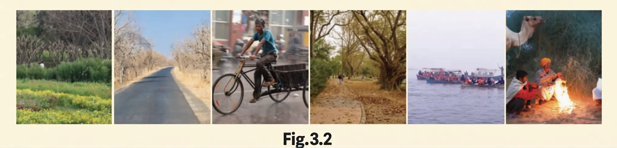
| Ritu | Season |
|---|---|
| Vasanta | Spring |
| Grishma | Summer |
| Varsha | Rainy season |
| Sharad | Autumn |
| Hemanta | Pre-winter |
| Shishir | Winter |
Seasonal Life and Traditions
- Culture: Seasonal rituals and festivals include Vasanta Panchami and Sharad Purnima.
- People: Crops, food and clothing change with the seasons.
- Plants: Depending on the region, trees may bloom in spring or shed leaves and change colour as autumn approaches.
- Animals: Some animals develop thicker fur during cold winter months.
Recent Climate Changes
- Climate usually remains stable over long periods.
- Scientists have recorded climate changes around the world in recent decades.
- Studies indicate that many of these changes have been caused by human actions.
Types of Climates in India
| Climate type and region | Main conditions | Key detail |
|---|---|---|
| Alpine — Himalayas in the north | Cold, snowy winters and cool summers | Found in the high northern mountains |
| Temperate — lower Himalayas and many hilly areas | Moderately cold winters and summers that are not too hot | Many hill stations offer relief from the heat of the plains |
| Subtropical — northern plains | Very hot summers and cold winters | Most of India’s wheat is grown here |
| Arid — Thar Desert in the west | Extremely hot days, cool nights and very little rainfall | People have developed ways to collect and save water |
| Semi-arid — central Deccan Plateau | Hot summers, mild winters and moderate rainy-season rainfall | Rainfall occurs during the rainy season |
| Tropical — eastern India and southern peninsula | Mild winters and distinct wet and dry periods | Wet and dry periods are controlled by monsoon winds |
Latitude and Climate Terms
- Tropics: The terms tropical and subtropical are related to two special parallels of latitude called the tropics.
- Ritu
- A traditional Indian season.
- Monsoon
- India’s rainy season, occurring during a particular period of the year.
- Arid
- Very dry, with very little rainfall.
- Semi-arid
- A climate with limited rainfall, such as the central Deccan Plateau’s moderate rainy-season rainfall.
- Temperate
- A climate with moderately cold winters and summers that are not too hot.
- Tropics
- Two special parallels of latitude related to the terms tropical and subtropical.
How are weather, seasons and climate related?
Name the six traditional Indian seasons.
Describe the climates of the northern plains and the Thar Desert.
Quick recap
- Weather describes short-term conditions; climate is a region’s weather pattern over several decades or more.
- Seasons recur annually, and seasonal weather is connected to climate.
- India has the monsoon rainy season as well as the common four seasons.
- Traditional Indian calendars recognise six ritus, linked with festivals and seasonal ways of life.
- Plants, animals and human activities respond to seasonal changes.
- India has alpine, temperate, subtropical, arid, semi-arid and tropical climate regions.
- Tropical and subtropical are terms related to the two special parallels of latitude called the tropics; many recent climate changes are attributed to human actions.
Factors Determining the Climate Part-1
Climate factors
- Factors that shape climate can operate globally, regionally or locally.
Latitude
Latitude — The distance of a place north or south of the Equator, increasing towards either pole.
How latitude affects temperature
- Low latitudes: Places near the Equator are generally warmer; the Sun’s rays strike nearly perpendicular to the surface, concentrating energy over a smaller area.
- High latitudes: Near the poles, the rays arrive obliquely and spread their energy over a larger area.
- Atmospheric path: Oblique rays pass through more of the atmosphere, losing more energy before reaching the surface.
- Result: Polar regions receive less heat than the Equatorial region, so temperatures generally fall as latitude increases.
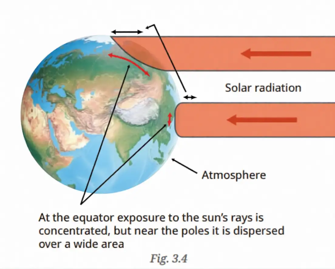
| Point | Equatorial region | Polar region |
|---|---|---|
| Latitude | Low | High |
| Sun’s rays | Nearly perpendicular; energy concentrated | Oblique; energy spread over a wider area |
| Heat received | More | Less |
| General climate | Warmer | Colder |
Examples in India
- Kanniyakumari and the Nicobar Islands: Close to the Equator, so they remain warm or hot for much of the year.
- Srinagar: Farther north, so it is much cooler.
Altitude
Altitude — The height of a place above sea level; temperature generally decreases as altitude increases.
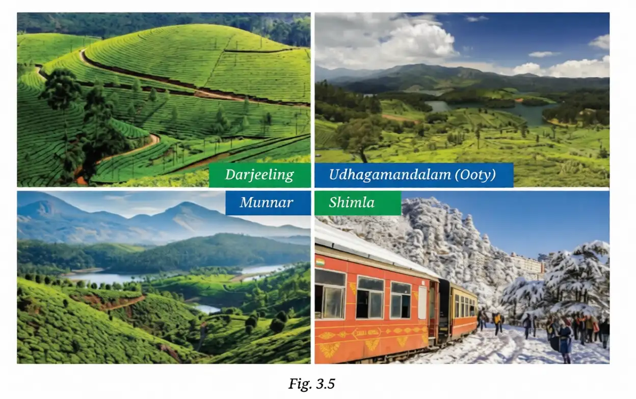
Why higher places are cooler
- Air pressure and density: Both decrease with altitude; the less dense air is cooler.
- Heating from Earth’s surface: The Sun heats the surface, and air farther from it is less heated.
- High mountains: Many Himalayan peaks stay below water’s freezing point and remain covered in snow.
| Region | Hill stations |
|---|---|
| South India | Munnar, Theni, Udhagamandalam (Ooty), Madikeri |
| Other parts of India | Mahabaleshwar, Mount Abu, Shimla, Nainital, Darjeeling, Tawang, Shillong |
| Point | Ooty | Coimbatore |
|---|---|---|
| Latitude | Almost the same | Almost the same |
| Summer temperature range | – | – |
| Main reason for difference | Higher altitude makes it cooler | Lower altitude makes it warmer |
Why is Ooty cooler than Coimbatore even though both are at almost the same latitude?
Quick recap
- Latitude increases away from the Equator; places near the Equator are generally warmer than places near the poles.
- Perpendicular solar rays concentrate energy, while oblique rays spread it over a wider area and pass through more atmosphere.
- In India, Kanniyakumari and the Nicobar Islands are warm or hot, while northern Srinagar is cooler.
- Temperature generally decreases as altitude increases because air pressure and density fall and the air is farther from the heated surface.
- Ooty is cooler than Coimbatore mainly because it is at a higher altitude, despite their similar latitude.
Factors Determining the Climate Part-2
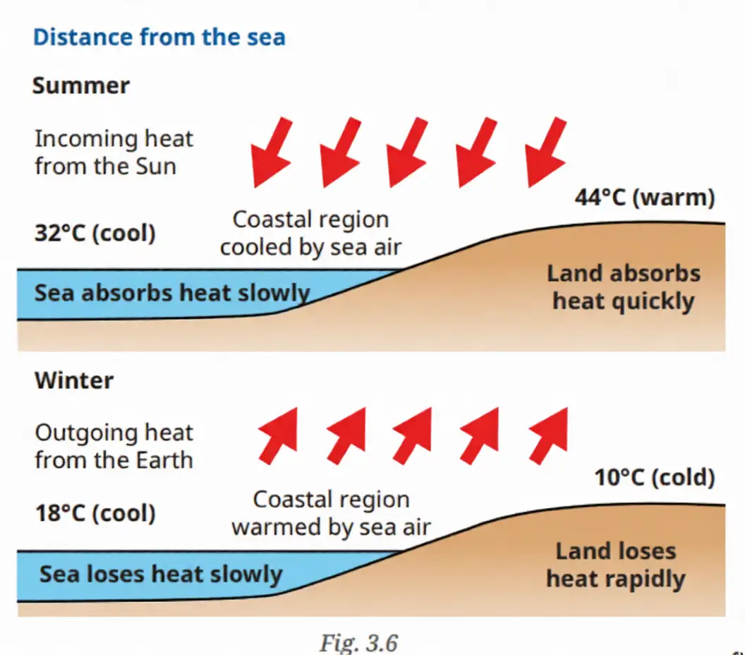
Proximity to the Sea
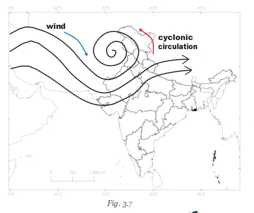
Winds
Topography
- Topography: The physical surface features of an area, such as mountains, hills, valleys, slopes and coasts.
- Influence on climate: Landforms can block or expose regions to winds; the Himalayas and Karakoram protect India from some cold Central Asian winds, while the open Thar Desert is exposed to hot, dry winds.
Climate and Microclimates
Microclimate — A microclimate is the climate of a small area that differs from the climate of the surrounding region.
Examples and Effects
- Local conditions: A microclimate has its own pattern of temperature, humidity and precipitation.
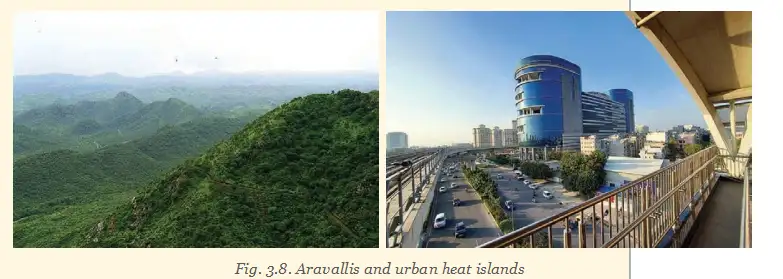
- Examples: Enclosed valleys, some forests and urban heat islands can have microclimates.
- Urban heat island: Cities with many buildings and concrete surfaces but little vegetation trap heat and may be warmer than nearby areas.
- Effects: Microclimates can influence local plants and animals, the crops grown, and human health and well-being.
- Temperature range
- The difference between a place’s maximum and minimum temperatures.
- Topography
- The physical surface features of an area.
- Microclimate
- The distinct climate of a small area within a larger region.
- Urban heat island
- A built-up city area that is warmer than surrounding areas because heat is trapped and vegetation is limited.
Why does Mumbai have a smaller temperature range than Nagpur?
What is a microclimate? Give two examples.
Quick recap
- The sea moderates coastal temperatures; inland areas tend to have more extreme summers and winters.
- Hot, dry winds can cause heat waves; cold winds can cause cold waves; moist sea winds may bring rain.
- Topography can shelter regions from winds or leave them exposed.
- Climate describes temperature, precipitation and wind patterns over three decades or more.
- Microclimates are local climate differences found in places such as valleys, forests and cities.
- Urban heat islands are often warmer because built surfaces trap heat and vegetation is scarce.
The Monsoons
Monsoon — Seasonal winds over a large area of the Indian Ocean and surrounding regions, including Australia, Africa and South Asia; the word comes from the Arabic mausim, meaning “season”.
Why the monsoon matters
- Importance: Monsoon rains fill rivers, soak the soil and support crop growth and life.
- Common use: “Monsoon” often refers to the seasonal rains brought by the winds.
How Monsoon Winds Form
The seasonal mechanism
- Key principle: Land heats up and cools down faster than the ocean, creating seasonal differences in temperature and air pressure.
- Wind movement: Air flows from high-pressure areas towards low-pressure areas.
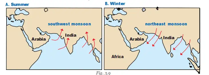
- Summer: Asian land heats strongly, creating low pressure; cooler ocean air flows towards the land.
- Rainfall: Ocean winds carry moisture, which condenses over land and falls as heavy rain.
- Winter: Land cools faster and becomes relatively high pressure while the warmer ocean is lower pressure; winds reverse and flow towards the ocean, bringing dry conditions to much of Asia.
Monsoons in India
Seasonal pattern in India
- Early JuneSouthwest monsoon rains typically reach the southern tip of India.
- Following weeks, by mid-JulyThe rains advance northward and cover the entire subcontinent.
- As winter approachesWinds reverse direction and the winter or northeast monsoon sets in.
Summer or southwest monsoon
- Direction: The winds come from the southwest and bring moist air from the ocean.
- Uneven advance: The rains do not spread smoothly or evenly across India.
- Western Ghats: Their western slopes receive much rainfall because the mountains act as a natural barrier.
- Deccan Plateau: East of the Western Ghats, it receives less rain, often with interruptions.
| Feature | Southwest monsoon | Northeast monsoon |
|---|---|---|
| Season | Summer | Winter |
| Wind direction | From the southwest, ocean to land | From the land towards the ocean; called northeast monsoon in India |
| Moisture and effect | Moist winds bring heavy rain | Mostly dry winds bring cold weather to south India; after crossing the Bay of Bengal, some winds collect moisture and bring rain to parts of east and south India |
Rainfall and Traditional Knowledge
Rainfall facts and local signs
- Mawsynram: In Meghalaya, it receives the world’s highest average annual rainfall—about 11,000 mm, or 11 m.
- Konkan coast: Fishermen may predict the monsoon’s onset when fish that normally stay underwater appear at the surface.
- Southern India: In some areas, people say the monsoon arrives within 50 days after the Golden Shower tree (*Cassia fistula*) blossoms.
- Crow nests: Some communities believe high nests indicate less rainfall, while low nests suggest heavy rainfall.
- Heritage: Traditional weather knowledge comes from careful local observation and experience, and is worth preserving.
- Southwest monsoon
- Summer winds from the southwest that bring moist air and rain to India.
- Northeast monsoon
- Winter winds that are mostly dry but bring rain to parts of east and south India after crossing the Bay of Bengal.
- Traditional weather knowledge
- Local weather predictions based on observations and experience passed through communities.
How does seasonal heating of land and ocean create monsoon winds?
Why do the Western Ghats receive more rain than the Deccan Plateau?
Quick recap
- Monsoon means seasonal winds over a broad region of the Indian Ocean and surrounding areas; commonly, it also means the rains they bring.
- Seasonal pressure differences form because land heats and cools faster than the ocean.
- The southwest monsoon brings summer rain, reaching southern India in early June and covering the subcontinent by mid-July.
- The Western Ghats receive much rain on their western slopes, while the Deccan Plateau receives less.
- The northeast monsoon is mostly dry, but moisture picked up from the Bay of Bengal brings rain to parts of east and south India.
- Mawsynram in Meghalaya receives about 11,000 mm of average annual rainfall.
Climate and Our Lives Part-1
Climate, Culture and the Economy
How climate shapes life
- Culture: Seasonal and agricultural cycles influence local festivals, dances and rituals across India.
- Economy: Climate affects agriculture and many industries, which often need predictable weather and available water.
- Monsoon failure: Poor monsoon rainfall can harm agriculture, raise food prices and put pressure on livelihoods.
Effects of monsoon failure
- Poor monsoon rainfall
- Agriculture suffers and water becomes harder to find; women may need to walk long distances for it
- Agricultural labourers may migrate to cities
- Grains, vegetables and fruits become costlier, contributing to inflation

Climates and Disasters
Climate-related disasters
- Examples: Cyclones, floods and landslides can occur under extreme weather conditions.
- Effects: Disasters can cause loss of life, disrupt agriculture, damage infrastructure and disturb local economies.
Cyclones
Cyclone — A powerful rotating storm that can form when an intense low-pressure system over the sea draws in moist air at high wind speeds.
Cyclones in India
- Where: Cyclones affect the Indian coastline every year, especially the eastern coast.
- Damage: Severe cyclones can cause deaths among people and animals, damage property and infrastructure, uproot trees and erode soil.
- Monitoring: The India Meteorological Department (IMD) tracks cyclones and shares information about their formation, development and landfall.
Disaster response
- National Disaster Response Force (NDRF): A specially trained force that responds to natural and human-made disasters.
- Role: NDRF teams help with rescue and evacuation during cyclones, landslides and floods; its battalions are located at 12 places in India.
How a cyclone forms
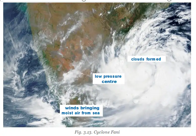
- Pressure over the sea becomes lower than in surrounding areas, forming a low-pressure system.
- Air from surrounding areas moves towards the low-pressure area.
- Moist air from the sea moves in, bringing moisture and rain.
- If the low pressure becomes intense and winds are fast, a cyclone may develop.
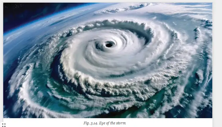
- Moist winds form clouds that spiral inwards; the cloudless centre is the cyclone’s eye.
Eye of a cyclone — The cloudless centre of a cyclone, around which the moist winds and cloud bands rotate inwards.
Cloud — A mass of water droplets, ice crystals or both, suspended in the atmosphere.
- Monsoon failure
- Poor rainfall during the monsoon season.
- Low-pressure system
- An area where air pressure is lower than in surrounding areas, drawing air towards it.
- Landfall
- The place where a cyclone reaches the coast.
- Inflation
- A rise in the prices of goods, including food.
How can monsoon failure affect people and the economy?
How does a cyclone form, and what is its eye?
Quick recap
- Climate influences local festivals and agricultural traditions.
- Monsoon failure can damage farming, increase water hardship, prompt migration and raise food prices.
- Cyclones, floods and landslides can harm people, infrastructure, agriculture and local economies.
- The IMD tracks cyclones and provides information about their development and landfall.
- An intense low-pressure system over the sea, moist incoming air and high wind speeds can produce a cyclone.
- The cyclone’s cloudless centre is its eye; clouds consist of suspended water droplets, ice crystals or both.
- The NDRF responds to disasters and supports rescue and evacuation.
Climate and Our Lives Part-2
Floods
Flood — A flood occurs when water overflows onto land that is normally dry.
- Heavy rain: Run-off may exceed the amount of water the land can absorb.
- Overflowing water bodies: Rivers or lakes may collect too much water, overflow or breach their banks.
- Season: Floods occur frequently during the monsoon.
- Vulnerable states: Uttar Pradesh, Bihar, Kerala, Andhra Pradesh and Assam are particularly flood-prone.
| Flood type | How it occurs | Key effect |
|---|---|---|
| Rainfall and river floods | Heavy rain creates excess run-off, or rivers and lakes overflow or breach their banks. | Water spreads over normally dry land. |
| Glacial-lake floods | A glacial lake’s rock-and-ice barrier gives way under pressure. | A sudden, potentially devastating glacial burst. |
| Urban floods | Heavy rain overwhelms drainage; construction may block waterways, while concrete and asphalt prevent water absorption. | Water accumulates in built-up areas. |
Glacial burst — A glacial burst occurs when water breaks through the rock-and-ice barrier holding a glacial lake.
Uttarakhand Glacial Burst
- 2013Continuous heavy rain over several days triggered a glacial burst in Uttarakhand. Landslides followed; areas around Kedarnath temple, villages, roads and bridges were devastated. About 6,000 people, many of them pilgrims, died.
Causes of Urban Flooding
- Heavy rainfall
- Overburdened drainage, blocked waterways or construction encroaching on waterways
- Concrete and asphalt prevent water from soaking into the ground
- Water accumulates and floods city areas
Landslides
Landslide — A landslide is the sudden collapse or movement of rock, soil or debris down a slope.
- Natural triggers: Heavy rain, earthquakes and volcanic activity can trigger landslides; they often occur during the monsoon.
- Common regions: Himachal Pradesh, Uttarakhand, Sikkim, Arunachal Pradesh, the Western Ghats and other hilly areas.
- Human activities: Deforestation, infrastructure built without approved methods and excessive construction can increase landslide risk.
- Water flow: Buildings and other construction may block the natural flow of water, further raising the risk.
Forest Fires
Forest fire — A forest fire is an uncontrolled fire that spreads rapidly across vegetation.
- Natural conditions: Dry weather, drought and high winds can fuel fires.
- Human cause: Carelessness is another frequent cause.
- Common areas: Uttarakhand, Himachal Pradesh, Madhya Pradesh, Chhattisgarh and the Western Ghats have extensive forest or grassland areas.
- Impacts: Fires destroy forests, harm wildlife, degrade ecosystems, worsen air quality and displace local communities.
- Consequences: Damage affects both the environment and the economy.
- Run-off
- Water that flows over land when it cannot soak into the ground.
- Glacial lake
- A lake in a glacial region whose water is held back by a barrier of rock and ice.
- Glacial burst
- A sudden release of water when a glacial lake’s barrier breaks.
- Landslide
- The sudden collapse or movement of rock, soil or debris down a slope.
- Forest fire
- An uncontrolled fire that spreads rapidly through vegetation.
What causes urban flooding?
How can human activities increase landslide risk?
Quick recap
- Floods occur when excess water spreads onto normally dry land and are common during the monsoon.
- Glacial lakes can burst when rapid melting or heavy rain builds pressure behind their rock-and-ice barriers.
- Urban drainage problems, blocked waterways and non-absorbent surfaces can worsen flooding.
- Landslides are triggered by heavy rain, earthquakes or volcanic activity; human land use can raise the risk.
- Forest fires spread through vegetation, aided by dry conditions, drought, high winds or human carelessness.
- Floods, landslides and forest fires can severely harm people, property, ecosystems and economic life.
Climate Change
Meaning and Causes of Climate Change
- Meaning: Climate change is a significant, long-term shift in climate, including changes in temperature, precipitation and weather events.
- Natural causes: Natural processes have driven climate change over millions of years.
- Human causes: Since the 19th century, fossil-fuel burning, deforestation, harmful industrial practices and excessive consumption have been major causes.
- Global warming: Human activities release extra greenhouse gases, which trap more heat and disrupt established climate patterns.
Before we move on
Weather, Seasons and Climate
| Point | Weather | Seasons | Climate |
|---|---|---|---|
| Time pattern | Short-term conditions | Patterns that recur yearly | Long-term patterns over decades |
What Shapes India's Climate?
Climate factors and regional diversity
- Geography: India's mountains, deserts and plateaus contribute to its diverse climate.
- Main factors: Latitude, altitude, distance from the sea, winds and topography influence climate.
Why Climate Matters
Monsoons and livelihoods
- Monsoon rainfall → affects crop cycles
- Crop cycles → influence agriculture and livelihoods
Climate and daily life
- Culture: Climate is connected with traditions and festivals.
- Economy: Agriculture and other economic activities are influenced by climate.
Climate risks and change
- Understanding climate → helps people prepare for hazards such as floods and cyclones.
- Climate change → more extreme weather or temperature → serious effects on nature and human life.
Quick recap
- Weather is short-term; seasons recur yearly; climate describes patterns over decades.
- India's varied landforms contribute to its diverse climate.
- Latitude, altitude, distance from the sea, winds and topography affect climate.
- Monsoons influence crops, agriculture and livelihoods.
- Climate is linked to culture, festivals and economic activity.
- Climate knowledge supports preparation for floods and cyclones.
- Climate change can intensify weather and temperature extremes, harming people and nature.
Social Science — ALL CHAPTERS
1
Geographical Diversity of India
2
Understanding the Weather
3
Climates of India
4
New Beginnings Cities and States
5
The Rise of Empires
6
The Age of Reorganisation
7
The Gupta Era: An Age of Tireless Creativity
8
How the Land Becomes Sacred
9
From the Rulers to the Ruled: Types of Governments
10
The Constitution of India - An Introduction
11
From Barter to Money
12
Understanding Markets
1
The Story of Indian Farming
2
India and Her Neighbours
3
Empires and Kingdoms: 6th to 10th Centuries
4
Turning Tides: 11th and 12th Centuries
5
India, a Home to Many
6
The State, the Government, and You
7
Infrastructure: Engine of India’s Development
8
Banks and the Magic of Finance